Tectonic and stratigraphic evolution of the Isle of Skye
| From: Bell, B.R. and Harris, J.W. An excursion guide to the geology of the Isle of Skye : Geological Society of Glasgow, 1986. © 1986 B.R. Bell & J.W. Harris. All rights reserved. October 2022 note: A new edition of the guide is now available. |

Chapter 10 Tectonic and stratigraphic evolution
(A) Introduction
The distribution of the geological units which crop out on Skye has been influenced by numerous tectonic events. First, all rocks of Cambro-Ordovician age, or older (see Chapter 2), have been affected, to some extent, by movements of the Moine and associated thrusts (see Section (10B), below). There is then a gap of over 200 m.y. in the geological record before the strata of the two Mesozoic sedimentary basins are encountered (see Section (10C), below). In addition, the Camasunary Fault, of Jurassic to Cretaceous age, influences pre-Tertiary outcrop patterns and probably was active during the evolution of these sedimentary basins (see Section (10D), below). Subsequently, the Lower Tertiary volcanic activity disrupted rocks of all ages and the extent of the lava field of north Skye appears to have been restricted by the shallow depression of the Sea of the Hebrides Basin (see Section (10C), below).
(B) The Moine Thrust Zone
Details of the geometry and distribution of the Moine group of thrusts and thrust sheets occurring on Skye have been published by Peach et al. (1910) and Cheeney and Matthews (1965). The thrust planes dip at a shallow angle to the east and are post- Cambro-Ordovician in age. The dominant transportation direction was to the west.
The oldest rocks involved in these tectonic events are Lewisian Gneisses (see Section (2A) of Chapter 2). Extensive erosion of these Archaean–Middle Proterozoic basement gneisses took place prior to the deposition of the Upper Proterozoic Torridonian and Moine sediments (see Sections (2B) and (2C) of Chapter 2). A further period of erosion followed before the deposition of Cambro-Ordovician strata (see Section (2D) of Chapter 2). Subsequently, all of these units were involved in the thrusting events.
Some outcrops of Torridonian and Cambro-Ordovician sedimentary rocks are, however, still in situ. These occur at Ord, on the west side of the Sleat Peninsula, and in Strath Suardal. The overlying Kishorn Thrust Sheet consists of Torridonian strata (Applecross Group, see Section (2B) of Chapter 2) and is separated from the Cambro-Ordovician sequence, below, by the Kishorn Thrust Plane (Table 1). Above the Kishorn Thrust Sheet are the Tarskavaig and Moine Thrust Sheets, composed, predominantly, of Moine Schists and Lewisian Gneiss, respectively (Table 1).
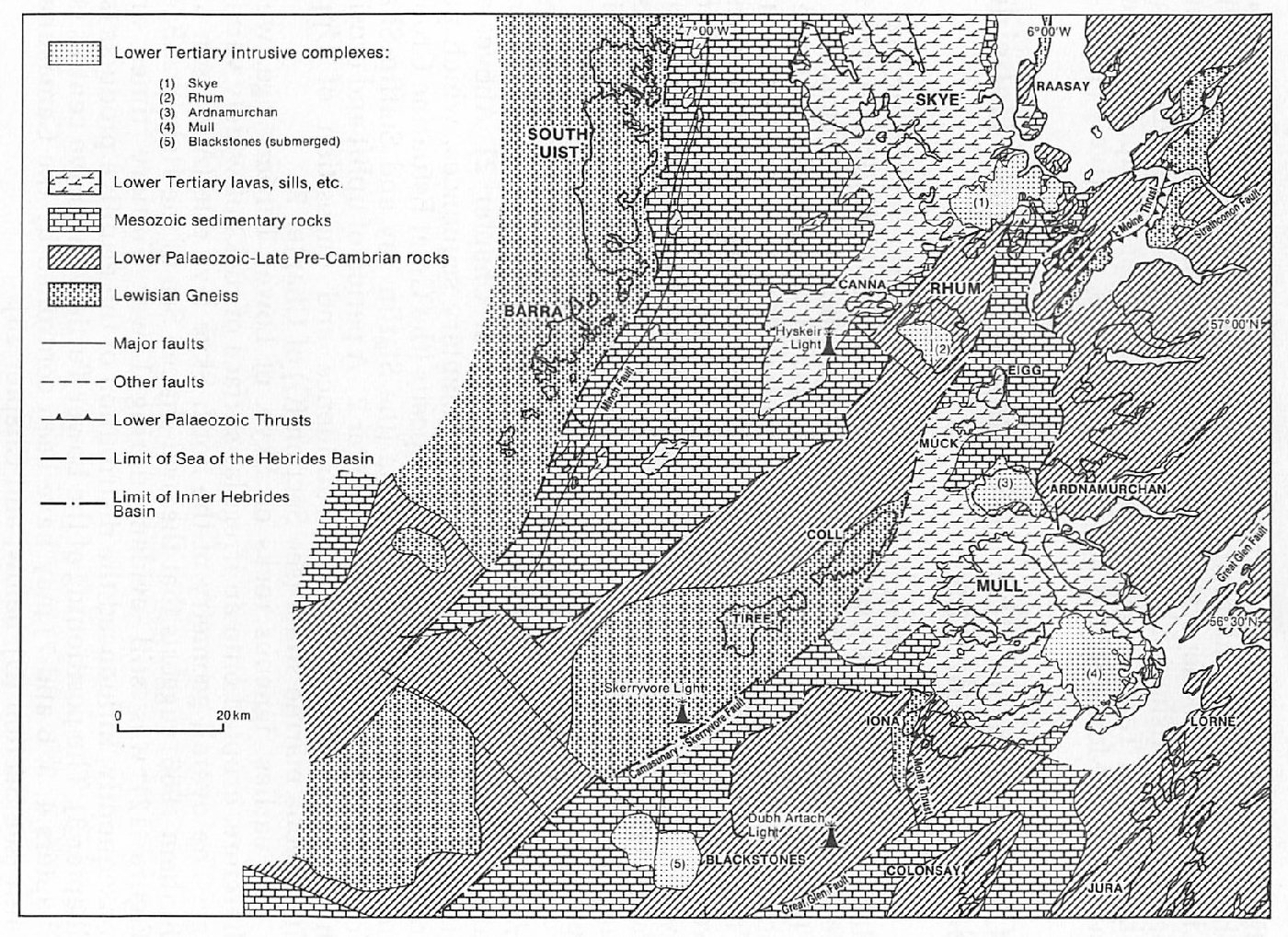
(C) The Sea of the Hebrides and Inner Hebrides Sedimentary Basins
Detailed sedimentological studies (for example, see the review by Hallam 1983) indicate that two distinct basins of deposition (Figure 12) developed within the Inner Hebrides region during Mesozoic times: (1) The Sea of the Hebrides Basin, represented by the Jurassic sequence of north Skye; and, (2) The Inner Hebrides Basin, represented by the Triassic and Jurassic sequence of central Skye. Separating the two basins was a horst-like structure, the SE side of which may be represented now by the Camasunary Fault (see Section (10D), below). In addition, the Minch Fault marks approximately the NW limit of the Sea of the Hebrides Basin and, like the Camasunary Fault, was most probably active during sedimentation (Steel 1977).
The oldest rocks attributable to either of these basins are coarse-grained, non-marine Triassic strata which were deposited in alluvial fans and on floodplains (see Section (2E) of Chapter 2). Above, are distinctly marine Lower Jurassic sedimentary sequences, which pass gradually upwards into estuarine deposits (the Great Estuarine Group), and thence back into marine strata (the Staffin .'lay and Staffin Shale Formations) (see Section (2F) of Chapter 2. A period of uplift and erosion then ensued before further subsidence and deposition of Upper Cretaceous marine strata (see Section (2G) of Chapter 2).
The earliest igneous rocks on Skye, of Lower Tertiary age, were, therefore, erupted onto an irregular surface of rocks of widely varying age. The overall geometry of the north Skye lava pile (Anderson and Dunham 1966) suggests that the oval-shaped Sea of the Hebrides Basin (Figure 12) was still evident during Lower Tertiary times and, consequently, influenced the distribution of the eruptive products (see Chapter 3). The positioning of the Lower Tertiary intrusive centres (see Chapters 4, 5, 6 and 7) may have been controlled by the Camasunary Fault (see Section (10D), below, and Chapter 13).
(D) The Camasunary Fault
The Camasunary Fault may be traced from Camasunary Bay, at the northern end of the Strathaird Peninsula, via a distinct spring-line, NE up the valley of the Abhainn nan Leac. The fault then disappears under Lower Tertiary intrusive and extrusive rocks in Coire Uaigneich, although its position may be inferred indirectly by the distribution of clast-types within the agglomerates and breccias on Belig (see Section (6B) of Chapter 6).
One of the most significant features of this fault is that it brings Torridonian and Middle to Upper Jurassic strata into juxtaposition, with an easterly downthrow of at least 600m. Upper Cretaceous strata and Lower Tertiary lavas, with no obvious displacement, are recorded from both sides of the fault, indicating that its main period(s) of movement was most likely pre-Upper Cretaceous.
There appears to be a close link between the Camasunary Fault and the Mesozoic sedimentary basins to the NW and SE (see Section (10C), above). Steel et al. (1975) and Steel (1977) consider that during the development of these basins, the Minch and Camasunary Faults (and other associated faults?) acted as submarine scarp slopes and controlled the distribution patterns of the sediment infills. The Torridonian strata which crop out in Camasunary Bay and further to the north (on the south side of Loch Sligachan) may have, at that time, been part of an emergent landmass.
References
Appendix 1: Glossary of petrological names and terms
Appendix 2: Glossary of fossil names
Appendix 3: Glossary of place names and grid references
| At all times follow: The Scottish Access Codeand Code of conduct for geological field work |