Hydrogeology of Democratic Republic of the Congo: Difference between revisions
No edit summary |
|||
| Line 136: | Line 136: | ||
==Hydrogeology== | ==Hydrogeology== | ||
This section provides a summary of the hydrogeology of the main aquifers in the Democratic Republic of the Congo. More information is available in the report [https://www.bgs.ac.uk/africagroundwateratlas/fulldetails.cfm?id=AGLA060006 UN (1989) (see References section, below). | This section provides a summary of the hydrogeology of the main aquifers in the Democratic Republic of the Congo. More information is available in the report [https://www.bgs.ac.uk/africagroundwateratlas/fulldetails.cfm?id=AGLA060006 UN (1989)] (see References section, below). | ||
The hydrogeology map shows a simplified version of the type and productivity of the main aquifers at a national scale (see [[Aquifer properties| the Aquifer properties resource page]] for more details). | The hydrogeology map shows a simplified version of the type and productivity of the main aquifers at a national scale (see [[Aquifer properties| the Aquifer properties resource page]] for more details). | ||
| Line 183: | Line 183: | ||
|| | || | ||
|} | |} | ||
==Groundwater Status== | ==Groundwater Status== | ||
Revision as of 09:04, 23 September 2015
Africa Groundwater Atlas >> Hydrogeology by country >> Hydrogeology of the Democratic Republic of the Congo
Most of the textual information on this page was taken from the chapter on the Democratic Republic of the Congo (then Zaire) in the report ‘Groundwater in Eastern, Central and Southern Africa’ (UN 1989). This information is outdated. If you have more recent information on the hydrogeology of the Democratic Republic of the Congo, please get in touch.
Compilers
Dr Kirsty Upton and Brighid Ó Dochartaigh, British Geological Survey, UK
Geographical Setting
The central part of the country is a large basin ranging in altitude from 350 to 700 m above sea level, with broad steep-sided valleys. To the east of this basin is a mountain ridge from 2300 to 3800 m above sea level that marks the edge of the East African Rift. To the south are the high Kasai and Shaba plateaus, from 1000 to 2000m above sea level. To the west are the Mayumbe hills, around 750 m in elevation, with narrow cols and valleys. To the north the basin is bounded by the watershed of the Oubangui river. The coastal area in the west, on the Atlantic Ocean, contains largely low land and sandy beaches, or cliffs.

General
| Estimated Population in 2013* | 67,513,677 |
| Rural Population (% of total) (2013)* | 58.5% |
| Total Surface Area* | 2,267,050 sq km |
| Agricultural Land (% of total area) (2012)* | 11.5% |
| Capital City | Kinshasa |
| Region | Central Africa |
| Border Countries | Republic of the Congo, Central African Republic, South Sudan, Uganda, Rwanda, Burundi, Tanzania, Zambia, Angola |
| Annual Freshwater Withdrawal (2013)* | 683.6 Million cubic metres |
| Annual Freshwater Withdrawal for Agriculture (2013)* | 10.5% |
| Annual Freshwater Withdrawal for Domestic Use (2013)* | 68% |
| Annual Freshwater Withdrawal for Industry (2013)* | 21.5% |
| Rural Population with Access to Improved Water Source (2012)* | 29% |
| Urban Population with Access to Improved Water Source (2012)* | 79.1% |
* Source: World Bank
Climate
The Democratic Republic of the Congo lies on the equator. Average temperatures across much of the country are around 25 degrees C, except in the eastern mountains where average temperatures are around 20 degrees C. There is much cloud cover over much of the year, with the maximum sunshine in the dry season.
Average annual rainfall for the whole country is over 1,200 mm, rising to more than 2,000 mm in the central basin, and falling to a minimum of around 850 mm at the western coast. There is a single rainy season, from September to June in the south and from February to November in the north; and a single dry season, in june and July in the south and December and January in the north.
-
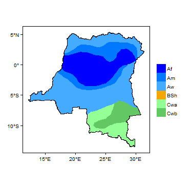
Koppen Geiger Climate Zones
-
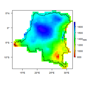
Average Annual Precipitation
-

Average Temperature


For further detail on the climate datasets used see the climate resources section.
Surface water
|
The Congo river - the largest river basin in Africa - drains all surface water in the country. It has many large tributaries, many of which have been dammed for hydroelectric power production. |
 |
Soil
 |
Land cover
 |
Geology
This section provides a summary of the geology of the Democratic Republic of the Congo. More information is available in the report UN (1989). (see References section, below).
The geology map shows a simplified version of the geology at a national scale (see the Geology resources page for more details).

Summary
The older Precambrian basement in the country is variously metamorphised and deformed. Overlying this are unmetamorphosed, largely undeformed sedimentary rocks: in the coastal zone, these are largely marine formations of Cretaceous and Tertiary age; and in the central basin they form a series of Upper Carboniferous to Cenozoic age. Overlying all of these rocks are Recent Quaternary weathered and/or unconsolidated sediments, such as valley alluvium and lateritic gravels.
| Key Formations | Period | Lithology | |
| Unconsolidated sedimentary | |||
|---|---|---|---|
| Alluvium and lacustrine deposits, lateritic gravels, and other unconsolidated deposits | Quaternary (Recent/Holocene) | Fine to coarse sands and gravels; clays and sandy clays. | |
| Sedimentary | |||
| Soft sandstones and argillaceous rocks | Cretaceous to Tertiary | ||
| Upper Carboniferous to Cretaceous | |||
| Basement | |||
| Crystalline, metamorphosed, basement rocks | Precambrian | Includes granitic and other igneous-metamorphic rocks, and metalimestones and dolomitic limestones (sometimes karstic). | |
Hydrogeology
This section provides a summary of the hydrogeology of the main aquifers in the Democratic Republic of the Congo. More information is available in the report UN (1989) (see References section, below).
The hydrogeology map shows a simplified version of the type and productivity of the main aquifers at a national scale (see the Aquifer properties resource page for more details).


Unconsolidated
| Named Aquifers | General Description |
| Alluvial sands; lateritic gravels |
Sedimentary - Intergranular Flow
| Named Aquifers | General Description |
Sedimentary - Intergranular & Fracture Flow
| Named Aquifers | General Description |
Sedimentary - Fracture Flow
| Named Aquifers | General Description |
| Metamorphosed limestones and dolomitic limestones |
Basement
| Named Aquifers | General Description |
Groundwater Status
Groundwater quantity
Groundwater quality
Groundwater use and management
Groundwater use
Groundwater management
Groundwater monitoring
Transboundary aquifers
For further information about transboundary aquifers, please see the Transboundary aquifers resources page
References
The following references provide more information on the geology and hydrogeology of the Democratic Republic of the Congo.
These, and others, can be accessed through the Africa Groundwater Literature Archive
United Nations. 1989. Groundwater in Eastern, Central and Southern Africa: Zaire. United Nations Department of Technical Cooperation for Development, Natural Resources/Water Series No.19, ST/TCD/6.
Return to the index pages
Africa Groundwater Atlas >> Hydrogeology by country >> Hydrogeology of the Democratic Republic of the Congo