Hydrogeology of Guinea: Difference between revisions
No edit summary |
No edit summary |
||
| Line 19: | Line 19: | ||
==Geographical Setting== | ==Geographical Setting== | ||
[[File:Guinea_Political.png | right | frame | Guinea | [[File:Guinea_Political.png | right | frame | Guinea. For more information on the datasets used to develop the map see the [[Geography | geography resource page]]]] | ||
===General=== | ===General=== | ||
| Line 67: | Line 67: | ||
[[File:Guinea_pre_Monthly.png| 255x124px| Average monthly precipitation for Guinea showing minimum and maximum (light blue), 25th and 75th percentile (blue), and median (dark blue) rainfall]] [[File:Guinea_tmp_Monthly.png| 255x124px| Average monthly temperature for Guinea showing minimum and maximum (orange), 25th and 75th percentile (red), and median (black) temperature]] [[File:Guinea_pre_Qts.png | 255x124px | Quarterly precipitation over the period 1950-2012]] [[File:Guinea_pre_Mts.png|255x124px | Monthly precipitation (blue) over the period 2000-2012 compared with the long term monthly average (red)]] | [[File:Guinea_pre_Monthly.png| 255x124px| Average monthly precipitation for Guinea showing minimum and maximum (light blue), 25th and 75th percentile (blue), and median (dark blue) rainfall]] [[File:Guinea_tmp_Monthly.png| 255x124px| Average monthly temperature for Guinea showing minimum and maximum (orange), 25th and 75th percentile (red), and median (black) temperature]] [[File:Guinea_pre_Qts.png | 255x124px | Quarterly precipitation over the period 1950-2012]] [[File:Guinea_pre_Mts.png|255x124px | Monthly precipitation (blue) over the period 2000-2012 compared with the long term monthly average (red)]] | ||
For | For more information on the datasets used to develop these maps and graphs see the [[Climate | climate resource page]]. | ||
===Surface water=== | ===Surface water=== | ||
| Line 76: | Line 76: | ||
| [[File:Guinea_Hydrology.png | frame | Major surface water features of Guinea | | [[File:Guinea_Hydrology.png | frame | Major surface water features of Guinea. For more information on the datasets used to develop the map see the [[Surface water | surface water resource page]]]] | ||
|} | |} | ||
| Line 82: | Line 82: | ||
{| | {| | ||
|- | |- | ||
| [[File:Guinea_soil.png | frame | Soil Map of Guinea | | [[File:Guinea_soil.png | frame | Soil Map of Guinea. For more information on the map see the [[Soil | soil resource page]]]] | ||
| | | | ||
| Line 92: | Line 92: | ||
| | | | ||
| [[File:Guinea_LandCover.png | frame | Land Cover Map of Guinea | | [[File:Guinea_LandCover.png | frame | Land Cover Map of Guinea. For more information on the map see the [[Land cover | land cover resource page]]]] | ||
|} | |} | ||
| Line 107: | Line 107: | ||
| [[File:Guinea_Geology.png | | | [[File:Guinea_Geology.png | center | thumb| 500px | Geology of Guinea at 1:5 million scale. For more information on how the map was developed see the [[Geology | geology resource page]]]] | ||
|} | |} | ||
==Hydrogeology== | ==Hydrogeology== | ||
The hydrogeology map below shows a simplified version of the type and productivity of the main aquifers at a national scale (see the [[Hydrogeology Map | | The hydrogeology map below shows a simplified version of the type and productivity of the main aquifers at a national scale (see the [[Hydrogeology Map | hydrogeology map]] resource page for more details). | ||
More information on the hydrogeology of Guinea is available in the report [https://www.bgs.ac.uk/africagroundwateratlas/fulldetails.cfm?id=AGLA060038 United Nations (1988)] (see References section, below). | More information on the hydrogeology of Guinea is available in the report [https://www.bgs.ac.uk/africagroundwateratlas/fulldetails.cfm?id=AGLA060038 United Nations (1988)] (see References section, below). | ||
[[File:Guinea_Hydrogeology.png]] [[File: Hydrogeology_Key.png | 500x195px]] | [[File:Guinea_Hydrogeology.png | center | thumb| 500px | Hydrogeology of Guinea at 1:5million scale. For more information on how the map was developed see the [[Hydrogeology Map | hydrogeology map]] resource page]] | ||
[[File: Hydrogeology_Key.png |center| 500x195px]] | |||
==Groundwater management== | ==Groundwater management== | ||
Revision as of 16:12, 6 April 2016
Africa Groundwater Atlas >> Hydrogeology by country >> Hydrogeology of Guinea
This page has limited information and needs to be updated. If you have more information on the hydrogeology of Guinea, please get in touch!
Compilers
Dr Kirsty Upton and Brighid Ó Dochartaigh, British Geological Survey, UK
Please cite this page as: Upton & Ó Dochartaigh, 2016.
Bibliographic reference: Upton, K. & Ó Dochartaigh, B.É. 2016. Africa Groundwater Atlas: Hydrogeology of Guinea. British Geological Survey. Accessed [date you accessed the information]. https://earthwise.bgs.ac.uk/index.php/Hydrogeology_of_Guinea
Terms and conditions
The Africa Groundwater Atlas is hosted by the British Geological Survey (BGS) and includes information from third party sources. Your use of information provided by this website is at your own risk. If reproducing diagrams that include third party information, please cite both the Africa Groundwater Atlas and the third party sources. Please see the Terms and Conditions for more information.
Geographical Setting

General
| Estimated Population in 2013* | 11,745,000 |
| Rural Population (% of total) (2013)* | 63.8% |
| Total Surface Area* | 245,720 sq km |
| Agricultural Land (% of total area) (2012)* | 58.6% |
| Capital City | Conakry |
| Region | Western Africa |
| Border Countries | Guinea-Bissau, Senegal, Mali, Cote d'Ivoire, Liberia, Sierra Leone |
| Annual Freshwater Withdrawal (2013)* | 553.3 Million cubic metres |
| Annual Freshwater Withdrawal for Agriculture (2013)* | 52.9% |
| Annual Freshwater Withdrawal for Domestic Use (2013)* | 37.7% |
| Annual Freshwater Withdrawal for Industry (2013)* | 9.4% |
| Rural Population with Access to Improved Water Source (2012)* | 65% |
| Urban Population with Access to Improved Water Source (2012)* | 92.2% |
* Source: World Bank
Climate
-

Koppen Geiger Climate Zones
-
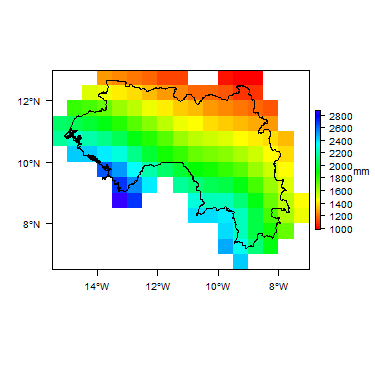
Average Annual Precipitation
-
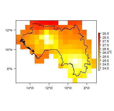
Average Temperature


For more information on the datasets used to develop these maps and graphs see the climate resource page.
Surface water
|
|
 |
Soil
 |
Land cover
 |
Geology
The geology map shows a simplified version of the geology at a national scale. More information is available in the report UN (1988) (see References section, below).
|
|
 |
Hydrogeology
The hydrogeology map below shows a simplified version of the type and productivity of the main aquifers at a national scale (see the hydrogeology map resource page for more details).
More information on the hydrogeology of Guinea is available in the report United Nations (1988) (see References section, below).


Groundwater management
The country has recently adopted programmes for improving water services: the National Drinking Water Supply and Sanitation Programme (NDWSSP) and the National Strategy for Development of Public Water Services in Rural and Semi-Urban Areas (SNDSPE). These programmes aim to address the current situation where local authorities have low capacity to implement their responsibility for water service projects in rural and semi-urban areas; and water services are largely being developed in a fragmented project-based way (African Development Bank Group 2013).
There is a central database with information on more than 16,000 water points - mainly boreholes - based on data from different projects that were supervised by the national water authority, but the data are not all well organised. It does, however, include more than 1000 borehole geological logs that are easy to access.
Transboundary aquifers
For further information about transboundary aquifers, please see the Transboundary aquifers resources page.
References
References with more information on the geology and hydrogeology of Guinea can be accessed through the Africa Groundwater Literature Archive.
African Development Bank Group. 2013. Institutional support for the national water point management service (SNAPE), Republic of Guinea. OWAS Department, December 2013.
United Nations. 1988. Groundwater in North and West Africa: Guinea. United Nations Department of Technical Cooperation for Development and Economic Commission for Africa, Natural Resources/Water Series No. 18.
Return to the index pages
Africa Groundwater Atlas >> Hydrogeology by country >> Hydrogeology of Guinea