Hydrogeology of Kenya
Africa Groundwater Atlas >> Hydrogeology by country >> Hydrogeology of Kenya
Authors
Maxwell Barasa, Rural Focus Ltd, Kenya
Emily Crane, Kirsty Upton, Brighid Ó Dochartaigh, British Geological Survey, UK
Geographical Setting

General
| Estimated Population in 2013* | 44353691 |
| Rural Population (% of total)* | 75.2% |
| Total Surface Area* | 569140 sq km |
| Agricultural Land (% of total area)* | 48.2% |
| Capital City | Nairobi |
| Region | Eastern Africa |
| Border Countries | Somalia, Ethiopia, South Sudan, Uganda, Tanzania |
| Annual Freshwater Withdrawal (2013)* | 2735 Million cubic metres |
| Annual Freshwater Withdrawal for Agriculture* | 79.16% |
| Annual Freshwater Withdrawal for Domestic Use* | 17.18% |
| Annual Freshwater Withdrawal for Industry* | 3.66% |
| Rural Population with Access to Improved Water Source* | 55.1% |
| Urban Population with Access to Improved Water Source* | 82.3% |
* Source: World Bank
Climate
-
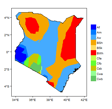
Koppen Geiger Climate Zones
-

Average Annual Precipitation
-

Average Temperature


Rainfall time-series and graphs of monthly average rainfall and temperature for each individual climate zone can be found on the Kenya Climate Page.


For further detail on the climate datasets used see the climate resources section.
Surface water
| Kenya's surface water features are dominated by the Rift Valley, which runs from north to south and bisects the plateaus region. Rivers drain to lakes on the floor of the Rift Valley. West of the Rift Valley, surface water flows towards Lake Victoria and into the Nile Basin; east of the Rift Valley, surface water flows southeast to the Indian Ocean.
The country has five large systems of drainage basins, with many small lakes in the intervening areas. These large basins are in turn subdivided into 52 main basins and sub-basins (United Nations 1989). |
 |
Soil

|
Land cover
 |
Geology
This section provides a summary of the geology of Kenya. More detail can be found in the references listed at the bottom of this page. Many of these references can be accessed through the Africa Groundwater Literature Archive.
The geology map on this page shows a simplified version of the geology at a national scale (see the Geology resources page for more details). The map is available to download as a shapefile (.shp) for use in GIS packages.

| Key Formations | Period | Lithology | Structure |
| Sedimentary - largely unconsolidated | |||
|---|---|---|---|
| Quaternary | Soils, alluvial beach sands, evaporates, fossil coral reefs and sandstones at the coast: alluvial and lacustrine sediments of the Rift Valley. | ||
| Tertiary | Coastal sediments, terrestrial and lacustrine sediments, including early Tertiary formations that do not crop out at the ground surface. Late Miocene and Pliocene volcanic rocks also occur (see below). | ||
| Igneous – largely volcanic | |||
| Name of formation1 | Tertiary-Quaternary | Late Miocene and Pliocene volcanic rocks within the Tertiary sequence. | |
| Sedimentary – Cretaceous-Tertiary | |||
| Name of formation1 | Cretaceous-Tertiary | Limestones and argillaceous limestones | |
| Sedimentary – Mesozoic-Palaeozoic | |||
| Duruma series; | Mesozoic-Palaeozoic | Palaeozoic and Mesozoic formations in Kenya are found near the coast and in the northeast.
The earliest of these rocks are Permo-Carboniferous, which are mostly sandstones and shales that form the Duruma series. This is equivalent to the Karroo system in southern Africa. Local formations are Taru; Maji-ya-Chumvi; Mariakani and the Mazeras. They extend for about 100 km from Taru to Mazeras, west of Mombasa. Mesozoic rocks occur in two separate areas, in the northeast of Kenya and along the coastal belt. The sratigraphy and fossils in the two areas are very distinct and it is likely that the sedimentary basins in the two areas were connected. Revision mapping in the area has come up with interesting lithological units that have revised lithological names. |
The rocks of the Duruma series between Taru and Mazeras dip very gently towards the ocean and are heavily faulted in places. |
| Precambrian | |||
| Bukoban system and Mozambique Belt | Proterozoic | The Kisii series of the Bukoban system comprises metamorphosed volcanic rocks with metasedimentary rocks.
The Mozambique belt is a structural unit within which a wide variety of metasedimentary and meta-igneous rocks are found, with a broad concordance of structural style and metamorphic history. The degree of deformation is intense in most of the rocks, and they are of high metamorphic grade. They were referred to in earlier literature as basement system rocks, due to the high degree of metamorphism and deformation. Recent work on the Mozambique Belt has shown that rocks can be sub-divided into groups of contrasting lithology, structure and composition of igneous rocks content. Rock types include quartzites, biotite/hornblende gneisses, schist, granitoid gneisses, amphibolites and migmatites, and there are intrusions of syntectonic granites. These groups are being studied in greater detail in order to come up with proper chronostratigraphic terminology. Within the Mozambique Belt, basic igneous complexes range in size from bosses to small dykes. They occur both east and west of the Rift Valley. Some of the older basic intrusions have undergone deformation and metamorphism to give orthoamphibolites and charnockitic gneisses. Basic and granitic intrusions are known in the Mozambique Belt. The majority of Mozambique rocks have been placed in upper Precambrian (Proterozoic). |
The most characteristic feature of the Mozambique Belt is its structural trend, which is more or less north-south across the entire belt. Variations of the northerly trend are minor and when observed can be explained and are localised. |
| Kavirondian and Nyanzian | Archaean | The Nyanzian and Kavirondian systems forming the Nyanza Craton are the oldest rocks in the country, with ages over 2,500 million years.
The Nyanzian system is mainly composed of lavas and pyroclastics with minor sediments (including shales and cherts) and banded ironstones. The Kavirondian, which rests uncomfortably on the Nyanzian, consists of grits, sandstones, mudstones, greywackes and conglomerates. Numerous granitic bosses and batholiths have intruded the Nyanzian and Kavirondian. There are more Kavirondian intrusions, but pre-Kavirondian intrusions are also widespread, and the two systems are discernible. |
Both the Nyanzian and Kavirondian systems are isoclinally folded about axes that have an east-westerly trend. Kavirondian, is only slightly younger than Nyanzian but folding in the two systems has similar orientation. |
Hydrogeology
This section provides a summary of the hydrogeology of the main aquifers in Kenya. More information is available in the references listed at the bottom of this page. Many of these references can be accessed through the Africa Groundwater Literature Archive.
The hydrogeology map on this page shows a simplified version of the type and productivity of the main aquifers at a national scale (see the Aquifer properties resource page for more details). The map is available to download as a shapefile (.shp) for use in GIS packages.


Unconsolidated
| Named Aquifers | General Description | Water quantity issues | Water quality issues | Recharge |
| Lotikipi and Lodwar aquifers | Alluvial sands and sediments. |
Igneous – mainly volcanic
| Named Aquifers | General Description | Water quantity issues | Water quality issues | Recharge |
| Volcanic | ”Volcanic rocks cover about 26 percent of the country. The petrology/lithology of these rocks includes phonolites, trachytes, tuffs and basalts. The thickness of these rocks varies from a few meters to several hundred metres and thereby implies that groundwater may occur at great depths. The successive lava flows are reflective of the old land surfaces. This means that in a borehole, more than five aquifer layers may be struck. Aquifers in these formations are often confined. The yields, depth to aquifers and static water level are also expected to vary significantly. Water in these rocks is of low total dissolved solids and high bicarbonate.” (Pavelic et al. 2012)
Boreholes in the volcanic rocks of Kenya can be drilled at depths up to 125 m (United Nations 1989). United Nations (1989) estimated that 9% of boreholes in volcanic rocks were abandoned on completion, due to poor yield or unsuitable water chemistry. They state an average yield of 7.6 m3/h for volcanic rocks (United Nations 1989). |
The volcanic deposits of the East African Rift System are rich in fluoride which leads to high groundwater fluoride concentrations. For example, concentrations over 10 mg/L were found in the Nairobi area (Coetsiers et al. 2008) | ||
| Nairobi Aquifer | The Nairobi Aquifer is in the Nairobi area. It comprises layered volcanics interbedded with old land surface and intervolcanic sediments. Boreholes are typically drilled to 250 - 400 m depth. | Overabstraction causing lowered water levels. | Generally good quality. | Recharge from Ngong Hills. |
| Kabatini aquifer | The Kabatini aquifer occurs within the volcanic rocks of the Nakuru area. Boreholes are typically drilled to about 150 m depth. | Elevated fluoride concentrations. | ||
| Gongoni and Baricho aquifers |
References:
Coetsiers, M., Kilonzo, F. & Walraevens, K. 2008. Hydrochemistry and source of high fluoride in groundwater of the Nairobi area, Kenya, Hydrological Sciences Journal, 53:6, 1230-1240, DOI: 10.1623/ hysj.53.6.1230
Consolidated Sedimentary - Intergranular Flow
| Named Aquifers | General Description | Water quantity issues | Water quality issues | Recharge |
| Name of aquifer | General Description of aquifer | Water quantity issues | Water quality issues | Recharge |
| Tiwi Aquifer | The Tiwi Aquifer occurs in the Kwale area. High yields can be obtained from the Mazeras sandstone and Pleistocene sands. Boreholes are typically 40 – 80 m deep. | Typically good quality. | ||
| Gongoni/Msambweni Aquifer | The Gongoni/Msambweni Aquifer occurs in the Kwale area. High yields can be obtained from the Mazeras sandstone and Pleistocene sands. Boreholes are typically 40 – 100 m deep. | Generally good quality, apart from high iron concentrations. | ||
| Baricho Aquifer | The Baricho Aquifer occurs in the Malindi area. The best yields are obtained from sand deposits. Boreholes are typically drilled to 25 – 60 m depth. | Generally good quality, sometimes elevated total dissolved solids (TDS) | ||
| Merti Aquifer | The Merti Aquifer occurs in Wajir County and comprises sandstone. “The Merti aquifer is defined by permeable water-bearing layers in the Merti Formation… The Merti Formation within the Anza Rift consists of rotated and faulted sediments and/or (near-)horizontal post-rift formations. The Anza Rift is bound by major faults.” (Oord et al. 2014)
“Generally, groundwater in the Merti aquifer is confined and is found at rather uniform depths between 110 and 180 m below ground level (m bgl). Successful boreholes tap the more permeable zone of the Merti Formation commonly between 105 m to 150 m bgl (GIBB, 2004). The actual thickness of the Merti Aquifer is unknown, because generally boreholes do not fully penetrate the aquifer.” (Oord et al. 2014). |
“Occurrence of saline water has been observed in the outer fringes of the Merti aquifer and is also believed to underlie the fresh water layer. … Water quality in the Dadaab refugee camps has deteriorated over time, mainly due to increasing salinity, and also in Habaswein evidence exists of some salinization as a result of long term abstraction (Mumma et al., 2011)” (Oord et al. 2014). |
|
References:
Oord, A., Collenteur, R. and Tolk, L. 2014. Hydrogeological Assessment of the Merti Aquifer, Kenya. Technical report no 1 of ARIGA. Assessing Risks of Investment in Groundwater Development in Sub-Saharan Africa. https://www.worldagroforestry.org/sites/default/files/TR1%20ARIGA-%20Hydrological%20Assessment%20of%20the%20Merti%20Aquifer%20Kenya.pdf
GIBB Africa Ltd., 2004. UNICEF Kenya Country Office - Study of the Merti Aquifer - Technical Report ISsue 2.0.
Mumma, A., Lane, M., Kairu, E., Tuinhof, A. and Hirji, R., 2011. Kenya: Groundwater Governance Case Study.
Consolidated Sedimentary - Intergranular & Fracture Flow
| Named Aquifers | General Description | Water quantity issues | Water quality issues | Recharge |
| Name of aquifer | General Description of aquifer | Water quantity issues | Water quality issues | Recharge |
Basement
| Named Aquifers | General Description | Water quantity issues | Water quality issues | Recharge |
| Name of aquifer | General Description of aquifer
|
Water quantity issues | Water quality issues | Recharge |
Groundwater Status
Groundwater quantity
The groundwater potential of Kenya is estimated to be 619 million m3 (Pavelic et al. 2012). The total present [as of 2012] groundwater abstraction rate in Kenya is estimated at 7.21 million m3/y. Total safe abstraction rate in Kenya is estimated to be 193 million m3/y (Ministry of Water Development. 1992) (Pavelic et al. 2012).
Groundwater quality
Most aquifers have groundwater quality issues. Some aquifers, mostly with recharge from fresh water rivers, are excellent groundwater sources e.g.: the Lodwar Aquifer recharged by the River Turkwel, the Merti Aquifer recharged by the River Ewaso, the Gongoni Aquifer recharged by the Mkurumudzi River and the Baricho Aquifer recharged by the River Galena.
The Nairobi aquifer has high fluoride concentrations which mostly exceed WHO standards, especially towards the Embakasi area.
The Lotikipi Aquifer is very saline with EC25 values exceeding 8000 µS/cm.
Surface water-groundwater interaction
Various contamination problems are arising due to the hydraulic continuity between surface water and shallow groundwater systems in Kenya, e.g.:
- Poor sewerage and drainage systems are major contributors to groundwater contamination, this is an increasing problem in Nairobi and its environs.
- Open cast mining of building blocks and stones pose a threat to groundwater as a result of contaminated water infiltrating into the ground.
- The Kiserian dam has suffered contamination problems due to inadequate sewage systems in nearby towns; this contaminated water may find its way into groundwater. Equally, groundwater may be becoming directly contaminated as a result of reliance on pit latrines and soakaway pits.
- River pollution by industrial wastes and sewage pose a great risk for groundwater protection.
Groundwater use and management
Groundwater use
Summary of groundwater use
Water supply systems in several towns are reliant on groundwater sources, e.g.: Mombasa and Malindi depends on Baricho well field, Kwale depends on Tiwi well field, Wajir town depends on Merti aquifer.
Mining activity, e.g. the Gongoni well field for Base Titanium mining company.
The Daadab refugee camp depends on groundwater abstracted from the Merti Aquifer.
Groundwater management
Summary of groundwater management
Transboundary aquifers
Kenya shares several transboundary aquifers with neighbouring countries, defined by IWMI (2014) as:
- AFS31 Coastal sedimentary basin 1 (Kenya/Tanzania) - Quaternary and consolidated sedimentary rocks
- AFS32 Kilimanjero aquifer (Kenya/Tanzania) - Volcanic alluvium
- AFNE1 Rift aquifer (Kenya/Tanzania/Uganda) - Volcanic
- AFNE2 Merti aquifer (Kenya/Somalia) - Semi-consolidated sedimentary
- AFNE3 Mount Elgon (Kenya/Uganda) - Volcanic
- AFNE4 Dawa (Ethiopia/Kenya/Somalia) - Volcanic rocks, alluvials and Precambrian basement
- AFNE5 Juba aquifer (Ethiopia/Kenya/Somalia) - Aquifers in Precambrian and intrusive rocks
- AFNE7 Sudd basin (Ethiopia/Kenya/South Sudan/Sudan) - Precambrian and volcanic rocks with patches of alluvials/sedimentary
Source: IWMI. 2014. Transboundary Aquifer Mapping and Management in Africa. https://www.iwmi.cgiar.org/Publications/Other/PDF/transboundary_aquifer_mapping_and_management_in_africa.pdf
For further information about transboundary aquifers, please see the Transboundary aquifers resources page
Groundwater monitoring
References
The following references provide more information on the geology and hydrogeology of Kenya.
These, and others, can be accessed through the Africa Groundwater Literature Archive
Geology: key references
Hydrogeology: key references
Ministry of Water Development. 1992. The Study on the National Water Master Plan. Prepared with the assistance of Japan International Cooperation Agency (JICA)
Pavelic, P.; Giordano, M.; Keraita, B.; Ramesh, V.; Rao, T.. 2012 Groundwater availability and use in Sub-Saharan Africa: a review of 15 countries.. International Water Management Institute.
United Nations. 1989. Groundwater in Eastern, Central and Southern Africa: Kenya. United Nations Department of Technical Cooperation for Development.
Other sources of data and information
- The Ministry of Mining – sells geological maps and geological reports carried out by the Geological Survey of Kenya: https://www.mining.go.ke/
- The Water Resources Management Authority licences their hydrogeological data (borehole logs, aquifer units and yields): https://www.wrma.or.ke/
- The National Oil Corporation of Kenya (NOCK) licences their seismic data, seismic lines and oil well logs: https://nationaloil.co.ke/site/3.php?id=1
- Samsam Water Foundation has a website with hydrogeological information: https://www.samsamwater.com/about.php
- University of Nairobi offers a platform on its website on student research topics which provides useful geological information: https://geology.uonbi.ac.ke/uon_student_projects
- International Livestock research institute (ILRI) has digitized and shapefiles of Kenya Geology, soils and landcover: https://data.ilri.org/geoportal/catalog/main/home.page
Return to the index pages
Africa Groundwater Atlas >> Hydrogeology by country >> Hydrogeology of Kenya