Hydrogeology of Malawi: Difference between revisions
No edit summary |
No edit summary |
||
| Line 119: | Line 119: | ||
!colspan="4"|Unconsolidated | !colspan="4"|Unconsolidated | ||
|- | |- | ||
| | |Alluvial and lacustrine deposits | ||
||Quaternary | ||Quaternary | ||
||Clays, silts, sands and occasionally gravels, deposited in the floor of the rift valley, and along the lakes in the major valley floors (UN 1989). The lithology of the deposits is highly variable. They occur particularly in several basins along the rift valley shore, including at Karonga and Salima-Nkhotajota lakeshores and the in upper and lower Shire Valley (Chavula 2012). They vary in thickness along Lake Malawi, tending to increase closer to the lake shore to a maximum of 60 m. In the centre of the Shire Valley, alluvium is 40 to 80 m thick, and reaches 150 m thick in the lower Shire Valley (UN 1989). | ||Clays, silts, sands and occasionally gravels, deposited in the floor of the rift valley, and along the lakes in the major valley floors (UN 1989). The lithology of the deposits is highly variable. They occur particularly in several basins along the rift valley shore, including at Karonga and Salima-Nkhotajota lakeshores and the in upper and lower Shire Valley (Chavula 2012). They vary in thickness along Lake Malawi, tending to increase closer to the lake shore to a maximum of 60 m. In the centre of the Shire Valley, alluvium is 40 to 80 m thick, and reaches 150 m thick in the lower Shire Valley (UN 1989). | ||
| Line 189: | Line 189: | ||
The aquifer tends to be unconfined. Groundwater can be in hydraulic continuity with adjacent rivers or lakes. Water table depth is typically between 5 m and 10 m below the ground surface (Chavula 2012). | The aquifer tends to be unconfined. Groundwater can be in hydraulic continuity with adjacent rivers or lakes. Water table depth is typically between 5 m and 10 m below the ground surface (Chavula 2012). | ||
Studies show that the average borehole yield from alluvial aquifers in Malawi is 15 l/s (litres/second); hydraulic conductivity ranges from 1 to 10 m/d; transmissivity ranges from 50 to 300 m²/day; and storage coefficient ranges from 1 x 10⁻² to 5 x 10⁻², and average borehole depth is 60 m (Chavula 2012). | |||
|| | || | ||
||Groundwater in alluvial aquifers is typically more mineralised than in basement aquifers, in some cases with salinity levels that are too high for potable water, such as in the lower Shire Valley and the eastern part of the Bwanje Valley (Chavula 2012). Chloride concentrations of up to 4000 mg/l and sodium concentrations up to 3600 mg/l have been recorded (Bath 1980). Salinity appears to be linked to the dissolution of evaporate minerals and/or evaporative concentration (BGS 2004). High fluoride concentrations of 2 to 20 mg/l have been found in some parts of the alluvial aquifers (Bath 1980). High iron concentrations of up to 80 mg/l and more are common (BGS 2004). | ||Groundwater in alluvial aquifers is typically more mineralised than in basement aquifers, in some cases with salinity levels that are too high for potable water, such as in the lower Shire Valley and the eastern part of the Bwanje Valley (Chavula 2012). Chloride concentrations of up to 4000 mg/l and sodium concentrations up to 3600 mg/l have been recorded (Bath 1980). Salinity appears to be linked to the dissolution of evaporate minerals and/or evaporative concentration (BGS 2004). High fluoride concentrations of 2 to 20 mg/l have been found in some parts of the alluvial aquifers (Bath 1980). High iron concentrations of up to 80 mg/l and more are common (BGS 2004). | ||
Revision as of 16:26, 1 July 2015
Africa Groundwater Atlas >> Hydrogeology by country >> Hydrogeology of Malawi
Authors
Author 1, Affiliation
Author 2, Affiliation
Geographical Setting

General
Malawi includes four main physiographic zones: highlands or uplands; plateau areas; the rift valley escarpment; and the rift valley floor/plains.
The uplands cover a relatively small area but reach 2000 m to 3000 m in elevation. The plateau areas cover much of the country, and are gently undulating surfaces from 750 m to 1300 m in altitude. They are cut into by wide valleys, or 'dambos', with grassy, swampy bases, which largely drain towards the rift valley floor. The rift valley escarpment consists of parallel faults with the land stepping down to the rift valley floor. The rift valley floor and plains extend along the shores of Lake Malawi and the upper Shire Valley; they have low relief and range from 100 m to 600 m in altitude.
| Estimated Population in 2013* | 16,400,000 |
| Rural Population (% of total) (2013)* | 84% |
| Total Surface Area* | 94,280 sq km |
| Agricultural Land (% of total area) (2012)* | 60.8% |
| Capital City | Lilongwe |
| Region | Eastern Africa |
| Border Countries | Tanzania, Mozambique, Zambia |
| Annual Freshwater Withdrawal (2013)* | 1,357 Million cubic metres |
| Annual Freshwater Withdrawal for Agriculture (2013)* | 85.9% |
| Annual Freshwater Withdrawal for Domestic Use (2013)* | 10.6% |
| Annual Freshwater Withdrawal for Industry (2013)* | 3.5% |
| Rural Population with Access to Improved Water Source (2012)* | 83.2% |
| Urban Population with Access to Improved Water Source (2012)* | 94.6% |
* Source: World Bank
Climate
Malawi has two main seasons: a wet season from November to April and a dry season from May to October. Rainfall is influenced by topography, with the highest rainfall in upland areas and on slopes explosed to the prevailing northeasterly wet season winds. Annual rainfall exceeds 800 mm over most of the country. Lake Malawi and the upper Shire Valley receive relatively low rainfall. There are large interannual variations in rainfall.
-
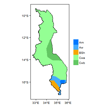
Koppen Geiger Climate Zones
-

Average Annual Precipitation
-
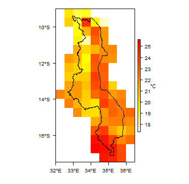
Average Temperature


Rainfall time-series and graphs of monthly average rainfall and temperature for each individual climate zone can be found on the Malawi Climate Page.


For further detail on the climate datasets used see the climate resources section.
Surface water
Lake Malawi is the largest water body in Malawi, and is the dominant control on the surface water drainage network in the country. The main rivers flowing into the lake are the Linthipe, Bua, Dwanga and Rukuru. These flow from wide 'dambos' that drain the plateau areas, which have steep valley sides tht shallow as they reach the rift valley.
Lake Malawi is drained entirely by the Shire River, which is a tributary of the Zambezi River. The upper Shire Valley has a wide alluvial plain, changing to a narrower valley with gorges and rapids in the lower part.
Lake Chilwa forms an internal drainage basin, mainly draining the northern uplands. Rivers flowing into the Chilwa basin tend to be ephemeral in their lower courses, losing water to permeable valley alluvial deposits.
 |
Soil
Soil compositions tend to be closely related to the underlying geology. Sandy soils occur on many granitic areas of the basement complex, and at the edges of alluvial plains. Latosols, including ferrosols, are common. Many soils are lateritic, typically 1 to 3 m thick (Smith-Carington and Chilton 1983), and sometimes 5 to 20 m thick (BGS 2004). Other soils include lithosols on steep slopes of the uplands and rift valley escarpment; hydromorphic (water logged) soils, including vertisols, in dambos; and calcimorphic soils on alluvial plains (Smith-Carington and Chilton 1983).
 |
Land cover
 |
Geology
This section provides a summary of the geology of Malawi. More detail can be found in the references listed at the bottom of this page. Many of these references can be accessed through the Africa Groundwater Literature Archive. The geology map on this page shows a simplified version of the geology at a national scale (see the Geology resources page for more details). The map is available to download as a shapefile (.shp) for use in GIS packages.

Summary
Most of the country is underlain by Precambrian to Lower Palaeozoic crystalline basement rocks. These are unconformably overlain in places, particularly in the north and south, by more recent sedimentary rocks or volcanic rocks. There is extensive Quaternary alluvium in valley bottoms and the rift floor plain.
The main structural feature is the rift valley, which was formed by a subsidence fault during the Upper Mesozoic and Cenozoic, and is still active. Lake Malawi and the Shire Valley lie on the floor of the rift valley (UN 1989).
| Key Formations | Period | Lithology | Structure |
| Unconsolidated | |||
|---|---|---|---|
| Alluvial and lacustrine deposits | Quaternary | Clays, silts, sands and occasionally gravels, deposited in the floor of the rift valley, and along the lakes in the major valley floors (UN 1989). The lithology of the deposits is highly variable. They occur particularly in several basins along the rift valley shore, including at Karonga and Salima-Nkhotajota lakeshores and the in upper and lower Shire Valley (Chavula 2012). They vary in thickness along Lake Malawi, tending to increase closer to the lake shore to a maximum of 60 m. In the centre of the Shire Valley, alluvium is 40 to 80 m thick, and reaches 150 m thick in the lower Shire Valley (UN 1989). | The alluvial deposits are faulted, caused by ongoing subsidence of the rift valley. |
| Cretaceous to Quaternary sedimentary rocks | |||
| Sungwa, Chiwondo, Chitembe, Dinosauric and Lupata | Cretaceous to Quaternary | These sedimentary rocks are found in small, narrow, elongated basins in the north of the country, running parallel to the shores of Lake Malawi. They include loosely consolidated sandstones and unconsolidated sands, sandy marls, clays and conglomerates, but are dominanted by aeolian desert sandstones, with abundant evaporite deposits in a limestone matrix (UN 1989). | |
| Igneous | |||
| Intrusive plutonic rocks | Jurassic | These occur in the Chilwa region in the south, and comprise granitic and syenitic plutonic rocks. | |
| Stormberg volcanic rocks | Jurassic | A series of basaltic lava flows, interbedded with layers of sandstone and tuff (UN 1989). | |
| Karoo | |||
| Karoo sedimentary series | Permian-Triassic | Karoo sedimentary rocks crop out in the north of Malawi, in north-south trending basins, and also to the southwest of the Shire Valley. They lie unconformably on crystalline basement. The base of the sedimentary sequence comprises conglomerates, sandstones, argillaceous rocks and coal seams; at the top of the sequence are arkosic sandstones, marls and more argillaceous rocks. The rocks are largely well cemented by calcite. They can be over 3500 m thick (UN 1989). | |
| Basement Complex | |||
| Crystalline Basement | Precambrian to Lower Palaezoic | Dominantly gneiss and granulite; also some metamorphic schists, quartzites and marbles (UN 1989). The Mafinga and Mchinjin groups in the north and east comprise mainly unmetamorphosed sandstones and conglomgerates. Across the whole basement complex are outcrops of intrusive igneous rocks, such as the Nyika and Dzanalyama granites, syenites, and pegmatite and dolerite dykes (UN 1989). | |
Hydrogeology
This section provides a summary of the hydrogeology of the main aquifers in Malawi. More information is available in the references listed at the bottom of this page. Many of these references can be accessed through the Africa Groundwater Literature Archive. The hydrogeology map on this page shows a simplified version of the type and productivity of the main aquifers at a national scale (see the Aquifer properties resource page for more details). The map is available to download as a shapefile (.shp) for use in GIS packages.


Summary
The two most important aquifer systems in Malawi are (Chavula 2012):
- unconsolidated alluvium in the major valleys and lake shore plains, which forms a high yielding aquifer in many areas; and
- crystalline basement rocks, which cover much of the country, and form a low yielding aquifer.
Unconsolidated
| Named Aquifers | General Description | Water quantity issues | Water quality issues | Recharge |
| Alluvial and lacustrine deposits | Alluvial and lacustrine deposits can form highly productive aquifers where they are better sorted and dominated by coarse grained sediment - sand and, sometimes, gravel - and where they are thick enough.
The aquifer tends to be unconfined. Groundwater can be in hydraulic continuity with adjacent rivers or lakes. Water table depth is typically between 5 m and 10 m below the ground surface (Chavula 2012). Studies show that the average borehole yield from alluvial aquifers in Malawi is 15 l/s (litres/second); hydraulic conductivity ranges from 1 to 10 m/d; transmissivity ranges from 50 to 300 m²/day; and storage coefficient ranges from 1 x 10⁻² to 5 x 10⁻², and average borehole depth is 60 m (Chavula 2012). |
Groundwater in alluvial aquifers is typically more mineralised than in basement aquifers, in some cases with salinity levels that are too high for potable water, such as in the lower Shire Valley and the eastern part of the Bwanje Valley (Chavula 2012). Chloride concentrations of up to 4000 mg/l and sodium concentrations up to 3600 mg/l have been recorded (Bath 1980). Salinity appears to be linked to the dissolution of evaporate minerals and/or evaporative concentration (BGS 2004). High fluoride concentrations of 2 to 20 mg/l have been found in some parts of the alluvial aquifers (Bath 1980). High iron concentrations of up to 80 mg/l and more are common (BGS 2004). | Recharge occurs from direct rainfall infiltration and, where the aquifers are in hydraulic contact with rivers or lake water, by losses from surface water. Studies estimate recharge to the eastern side of the lower Shire Valley alluvial aquifer at more than 200 mm/year (Chavula 2012). |
Sedimentary - Intergranular Flow
| Named Aquifers | General Description | Water quantity issues | Water quality issues | Recharge |
| Cretaceous to Quaternary sedimentary rocks |
Igneous Volcanic
| Named Aquifers | General Description | Water quantity issues | Water quality issues | Recharge |
| Stormberg volcanic rocks | The most porous and permeable parts are in the zones of contact between lava flows |
Sedimentary - Fracture Flow
| Named Aquifers | General Description | Water quantity issues | Water quality issues | Recharge |
| Karoo sedimentary sequence | The rocks of the Karoo are generally well-cemented with low porosity and intergranular permeability. Groundwater storage and flow occurs largely in fractures in the rocks. Groundwater levels are typically 20 m to 30 m below ground surface (UN 1989). |
Basement
| Named Aquifers | General Description | Water quantity issues | Water quality issues | Recharge |
| The basement complex rocks have virtually no primary (intergranular) permeability, but can form an aquifer where they have been sufficiently weathered in-situ, to form a layer of unconsolidated saprolitic weathered material. This weathered zone is best developed in the plateau areas, where it is often 15 m to 30 m thick, and locally even thicker (Chavula 2012). The best development of weathered saprolite tends to be associated with fractures, often along fracture zones.
The aquifer tends to be unconfined. The depth to water table is typically between 15 m and 25 m below the ground surface (Chavula 2012). Studies have shown the average borehole yield is 1 to 2 l/s; hydraulic conductivity ranges from 0.5 to 1.5 m/d; transmissivity ranges from 5 to 35 m²/day; and storage coefficient ranges from 1 x 10⁻² to 5 x 10⁻². Boreholes tend to be 45 to 50 m deep (Chavula 2012). |
Groundwater is typically of good quality, with slightly acidic to neutral pH (~6.4 to 7.0). Total dissolved solids (TDS) are generally less than 1000 mg/l, and typically around 350 mg/l (Chavula 2012), but occasionally elevated salinity is seen, sometimes linked to high sulphate concentrations, possibly linked to the dissolution of evaporate minerals (BGS 2004). Fluoride concentrations are typically relatively low, less than 1 mg/l (BGS 2004). |
Groundwater Status
Groundwater quantity
Groundwater quality
The quality of groundwater in Malawi is highly dependent on aquifer lithology, and is highly variable spatially. Nationally, groundwater is generally suitable for drinking water (Chavula 2012). Groundwater in alluvial aquifers is genearlly more mineralised than that in basement aquifers, and a number of boreholes in alluvial aquifers have been abandoned due to high salinity (Chavula 2012). Chemical parameters that are elevated in different areas include fluoride, sulphate, iron, chloride and nitrate. Fluoride concentrations of more than 1.5 mg/l are common in groundwater in alluvial aquifers in the Salima/Nkhotakota and Karonga lakeshore areas (Chavula 2012).
Generally, groundwater from boreholes is of better microbiological quality than groundwater from dug wells, which tend to be more vulnerable to contamination (Chavula 2012).
An overview of in groundwater quality is given in Bath 1980, BGS 2004, and Water Department/UNDP (1986).
Groundwater use and management
Groundwater use
Groundwater is widely used across Malawi. Data showed there were about 30,000 water boreholes and 8,000 protected hand dug wells in 2012 (Chavula 2012). Drought and poor water quality have meant more people are turning from hand dug wells to drilled boreholes. The use of motorised pumps is widespread, particularly by farmers. There is extensive use of groundwater for irrigation by smallholder farmers (Chavula 2012).
Groundwater management
Groundwater monitoring
Transboundary aquifers
For further information about transboundary aquifers, please see the Transboundary aquifers resources page
References
The following references provide more information on the geology and hydrogeology of Malawi. These, and others, can be accessed through the Africa Groundwater Literature Archive.
Geology: key references
Hydrogeology: key references
Bath AH. 1980. Hydrochemistry in groundwater development: report on an advisory visit to Malawi. British Geological Survey Report WD/OS/80/20.
BGS. 2004. Groundwater Quality: Malawi. British Geological Survey/WaterAid. https://www.wateraid.org/~/media/Publications/groundwater-quality-information-malawi.pdf
Chavula GMS. 2012. Malawi, in Groundwater Availability and Use in Sub-Saharan Africa: a review of fifteen countries. Pavelic P et al. (Eds). International Water Management Institute, Sri Lanka.
Smith-Carington AK and Chilton PJ. 1983. Groundwater resources of Malawi. Department of Lands, Valuation and Water; Republic of Malawi, Lilongwe.
UN. 1989. Malawi: Ground water in Eastern, Central and Southern Africa. Natural Resources/Water Series No. 19, ST/TCD/6. United Nations Department of Technical Cooperation for Development.
Water Department/UNDP. 1986. National Water Resources Master Plan, Malawi Government.
Return to the index pages
Africa Groundwater Atlas >> Hydrogeology by country >> Hydrogeology of Malawi