Hydrogeology of Malawi: Difference between revisions
No edit summary |
No edit summary |
||
| Line 13: | Line 13: | ||
==Terms and conditions== | ==Terms and conditions== | ||
The Africa Groundwater Atlas is hosted by the British Geological Survey (BGS) and includes information from third party sources. Your use of information provided by this website is at your own risk. If reproducing diagrams that include third party information, please cite both the Africa Groundwater Atlas and the third party sources. Please see the [[Africa Groundwater Atlas Terms | The Africa Groundwater Atlas is hosted by the British Geological Survey (BGS) and includes information from third party sources. Your use of information provided by this website is at your own risk. If reproducing diagrams that include third party information, please cite both the Africa Groundwater Atlas and the third party sources. Please see the [[Africa Groundwater Atlas Terms of Use | Terms of use]] for more information. | ||
==Geographical Setting== | ==Geographical Setting== | ||
| Line 352: | Line 352: | ||
<!-- PLEASE DO NOT DELETE BELOW THIS LINE --> | <!-- PLEASE DO NOT DELETE BELOW THIS LINE --> | ||
[[Category:Hydrogeology by country|m]] | [[Category:Hydrogeology by country|m]] | ||
[[Category:Africa Groundwater Atlas]] | |||
Revision as of 11:18, 5 May 2016
Africa Groundwater Atlas >> Hydrogeology by country >> Hydrogeology of Malawi
Contributers
Dr Kirsty Upton, Brighid Ó Dochartaigh, British Geological Survey, UK
Brighton Chungwa, PhD Student, Cranfield University, UK/Malawi.
Please cite this page as: Upton, Ó Dochartaigh & Chungwa, 2016.
Bibliographic reference: Upton, K., Ó Dochartaigh, B.É. & Chungwa, B. 2016. Africa Groundwater Atlas: Hydrogeology of Malawi. British Geological Survey. Accessed [date you accessed the information]. https://earthwise.bgs.ac.uk/index.php/Hydrogeology_of_Malawi
Terms and conditions
The Africa Groundwater Atlas is hosted by the British Geological Survey (BGS) and includes information from third party sources. Your use of information provided by this website is at your own risk. If reproducing diagrams that include third party information, please cite both the Africa Groundwater Atlas and the third party sources. Please see the Terms of use for more information.
Geographical Setting

General
Malawi includes four main physiographic zones: highlands or uplands; plateau areas; the rift valley escarpment; and the rift valley floor/plains.
The uplands cover a relatively small area but reach 2000 m to 3000 m in elevation. The plateau areas cover much of the country, and are gently undulating surfaces from 750 m to 1300 m in altitude. They are cut into by wide valleys, or 'dambos', with grassy, swampy bases, which largely drain towards the rift valley floor. The rift valley escarpment consists of parallel faults with the land stepping down to the rift valley floor. The rift valley floor and plains extend along the shores of Lake Malawi and the upper Shire Valley; they have low relief and range from 100 m to 600 m in altitude.
| Estimated Population in 2013* | 16,400,000 |
| Rural Population (% of total) (2013)* | 84% |
| Total Surface Area* | 94,280 sq km |
| Agricultural Land (% of total area) (2012)* | 60.8% |
| Capital City | Lilongwe |
| Region | Eastern Africa |
| Border Countries | Tanzania, Mozambique, Zambia |
| Annual Freshwater Withdrawal (2013)* | 1,357 Million cubic metres |
| Annual Freshwater Withdrawal for Agriculture (2013)* | 85.9% |
| Annual Freshwater Withdrawal for Domestic Use (2013)* | 10.6% |
| Annual Freshwater Withdrawal for Industry (2013)* | 3.5% |
| Rural Population with Access to Improved Water Source (2012)* | 83.2% |
| Urban Population with Access to Improved Water Source (2012)* | 94.6% |
* Source: World Bank
Climate
Malawi has two main seasons: a wet season from November to April and a dry season from May to October. Rainfall is influenced by topography, with the highest rainfall in upland areas and on slopes explosed to the prevailing northeasterly wet season winds. Annual rainfall exceeds 800 mm over most of the country. Lake Malawi and the upper Shire Valley receive relatively low rainfall. There are large interannual variations in rainfall.
These maps and graphs were developed from the CRU TS 3.21 dataset produced by the Climatic Research Unit at the University of East Anglia, UK. For more information see the climate resource page.
-
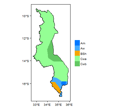
Koppen Geiger Climate Zones
-

Average Annual Precipitation
-
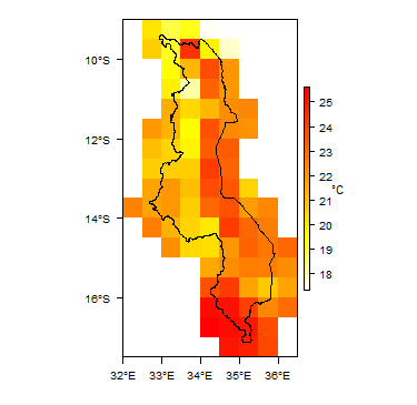
Average Temperature


Rainfall time-series and graphs of monthly average rainfall and temperature for each individual climate zone can be found on the Malawi Climate Page.


Surface water
Lake Malawi is the largest water body in Malawi, and is the dominant control on the surface water drainage network in the country. The main rivers flowing into the lake are the Linthipe, Bua, Dwangwa and Rukuru. These flow from wide 'dambos' that drain the plateau areas, which have steep valley sides that become less steep as they reach the rift valley.
Lake Malawi is drained entirely by the Shire River, which is a tributary of the Zambezi River. The upper Shire Valley has a wide alluvial plain, changing to a narrower valley with gorges and rapids in the lower part.
Lake Chilwa forms an internal drainage basin, mainly draining the northern uplands. Rivers flowing into the Chilwa basin tend to be ephemeral in their lower courses, losing water to permeable valley alluvial deposits.
 |
Soil
Soil compositions tend to be closely related to the underlying geology. Sandy soils occur on many granitic areas of the basement complex, and at the edges of alluvial plains. Latosols, including ferrosols, are common. Many soils are lateritic, typically 1 to 3 m thick (Smith-Carington and Chilton 1983), and sometimes 5 to 20 m thick (BGS 2004). Other soils include lithosols on steep slopes of the uplands and rift valley escarpment; hydromorphic (water logged) soils, including vertisols, in dambos; and calcimorphic soils on alluvial plains (Smith-Carington and Chilton 1983).
 |
Land cover

GeologyThis section provides a summary of the geology of Malawi. More detail can be found in the references listed at the bottom of this page. Many of these references can be accessed through the Africa Groundwater Literature Archive. The geology map on this page shows a simplified version of the geology at a national scale (see the Geology resource page for more details).  SummaryMost of the country is underlain by Precambrian to Lower Palaeozoic crystalline basement rocks. These are unconformably overlain in places, particularly in the north and south, by more recent sedimentary rocks or volcanic rocks. There is extensive Quaternary alluvium in valley bottoms and the rift floor plain. The main structural feature is the rift valley, which was formed by a subsidence fault during the Upper Mesozoic and Cenozoic, and is still active. Lake Malawi and the Shire Valley lie on the floor of the rift valley (UN 1989).
HydrogeologyThis section provides a summary of the hydrogeology of the main aquifers in Malawi. More information is available in the references listed at the bottom of this page. Many of these references can be accessed through the Africa Groundwater Literature Archive.
 SummaryThe two most important aquifer systems in Malawi are (Chavula 2012):
There are only small occurences of other rock types, and although these may be important locally, little is known of their hydrogeological properties.
Unconsolidated
Sedimentary - Intergranular Flow
Igneous Volcanic
Igneous Intrusive
Sedimentary - Fracture Flow
Basement
Groundwater StatusThe quality of groundwater in Malawi is highly dependent on aquifer lithology, and is highly variable spatially. Nationally, groundwater is generally suitable for drinking water (Chavula 2012). Groundwater in alluvial aquifers is genearlly more mineralised than that in basement aquifers, and a number of boreholes in alluvial aquifers have been abandoned due to high salinity (Chavula 2012). Chemical parameters that are elevated in different areas include fluoride, sulphate, iron, chloride and nitrate. Fluoride concentrations of more than 1.5 mg/l are common in groundwater in alluvial aquifers in the Salima/Nkhotakota and Karonga lakeshore areas (Chavula 2012). Generally, groundwater from boreholes is of better microbiological quality than groundwater from dug wells, which tend to be more vulnerable to contamination (Chavula 2012). An overview of in groundwater quality is given in Bath 1980, BGS 2004, and Water Department/UNDP (1986). Groundwater use and managementGroundwater useGroundwater is widely used across Malawi for both domestic and agricultural purposes. There were about 30,000 water boreholes and 8,000 protected hand dug wells in 2012 (Chavula 2012). Drought and poor water quality have meant more people are turning from hand dug wells to drilled boreholes. Estimates show that 65% of the population depends on groundwater for domestic supply: in rural areas, this rises to 82%, while in urban areas is it closer to 20%, although a number of towns or districts within towns get most of their water supply from groundwater (Chavula 2012). Groundwater is increasingly used for irrigation by smallholder farmers, often from hand dug wells, and increasingly using treadle pumps, particularly in dambo areas. There is also a large scale irrigation scheme in the Salima district, where groundwater from an alluvial aquifer is extensively used for horticultural crops and agro processing. Some farmers use groundwater for livestock watering (Chavula 2012). Boreholes fitted with hand pumps are standard for rural groundwater supplies. The use of motorised pumps is widespread, particularly by farmers; and treadle pumps are becoming more widely used.
Groundwater managementThe Water Resources Act of 1969 was replaced by the Water Resources Act of 2013. Part of the new Act was to establish the National Water Resources Authority. The Ministry of Irrigation and Water Development has responsibility for management of groundwater resources, among other water resources. Within the Ministry, the Departments of Water Resources and Water Supply are responsible for groundwater development policy. The Department of Water Resources currently has three sections: the Groundwater Division, Surface Water Division, and Water Quality board. Formerly, the Water Resources Board formed a fourth section within the Ministry, but under the Water Resources Act of 2013 this has now been replaced by the National Water Resources Authority (NWRA), an autonomous government sponsored body. The NWRA will eventually take over the roles of the former Water Resources Board, including (but not limited to) the following: - developing principles, guidelines and procedures for the allocation of water resources; - monitoring, and from time to time reassessing, the National Water Policy and the National Water Resources Master Plan; - managing water use permits; - regulating and protecting water quality from adverse impacts; - managing and protecting water catchments; - gathering and maintaining information on water resources and from time to time publishing forecasts, projections and information on water resources; - assisting the Minister in the coordination of hydrological and hydrogeological investigations; - coordinating the preparation and implementation of a water action plan.
The practical development of groundwater resources is currently dominantly carried out by NGOs, the donor community and the private sector, in collaboration with the Ministry of Irrigation and Water Development (Chavula 2012).
Groundwater monitoringGroundwater level monitoring is being carried out across a network of approximately 30 boreholes across the country, assisted by the use of automatic water level monitors. Some groundwater quality monitoring is also taking place. The monitoring network is currently being upgraded as part of a World Bank funded project on national hydrogeological and water quality mapping. Transboundary aquifersFor further information about transboundary aquifers, please see the Transboundary aquifers resources page
ReferencesThe following references provide more information on the geology and hydrogeology of Malawi. These, and others, can be accessed through the Africa Groundwater Literature Archive.
Geology: key referencesSmith-Carington AK and Chilton PJ. 1983. Groundwater resources of Malawi. Department of Lands, Valuation and Water; Republic of Malawi, Lilongwe. Hydrogeology: key referencesBath AH. 1980. Hydrochemistry in groundwater development: report on an advisory visit to Malawi. British Geological Survey Report WD/OS/80/20. BGS. 2004. Groundwater Quality: Malawi. British Geological Survey/WaterAid. https://www.wateraid.org/~/media/Publications/groundwater-quality-information-malawi.pdf Chavula GMS. 2012. Malawi, in Groundwater Availability and Use in Sub-Saharan Africa: a review of fifteen countries. Pavelic P et al. (Eds). International Water Management Institute, Sri Lanka. Smith-Carington AK and Chilton PJ. 1983. Groundwater resources of Malawi. Department of Lands, Valuation and Water; Republic of Malawi, Lilongwe. UN. 1989. Malawi: Ground water in Eastern, Central and Southern Africa. Natural Resources/Water Series No. 19, ST/TCD/6. United Nations Department of Technical Cooperation for Development. Water Department/UNDP. 1986. National Water Resources Master Plan. Malawi Government. NOTE this was replaced by an updated version, compiled by JICA, 2014. Return to the index pagesAfrica Groundwater Atlas >> Hydrogeology by country >> Hydrogeology of Malawi |
|||||||||||||||||||||||||||||||||||||||||||||||||||||||||||||||||||||||||||||||||||||||||||||||||||||||||||||