Hydrogeology of Somalia
Africa Groundwater Atlas >> Hydrogeology by country >> Hydrogeology of Somalia
Authors
Author 1, Affiliation
Author 2, Affiliation
Geographical Setting

General
| Estimated Population in 2013* | 10,495,583 |
| Rural Population (% of total) (2013)* | 61.4% |
| Total Surface Area* | 627,340 sq km |
| Agricultural Land (% of total area) (2012)* | 70.3% |
| Capital City | XXX |
| Region | XXX |
| Border Countries | XXX |
| Annual Freshwater Withdrawal (2013)* | 3,298 Million cubic metres |
| Annual Freshwater Withdrawal for Agriculture (2013)* | 99.48% |
| Annual Freshwater Withdrawal for Domestic Use (2013)* | 0.45% |
| Annual Freshwater Withdrawal for Industry (2013)* | 0.06% |
* Source: World Bank
Climate
-

Koppen Geiger Climate Zones
-
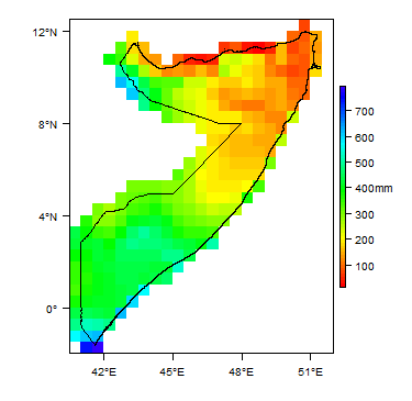
Average Annual Precipitation
-

Average Temperature


Rainfall time-series and graphs of monthly average rainfall and temperature for each individual climate zone can be found on the Somalia Climate Page.


For further detail on the climate datasets used see the climate resources section.
Surface water
|
|
 |
Soil
| Most of the soils in Somalia have low nutrient and moisture availability, including calcisols, gypisols, arenosols and solonchak and solonetz type soils that cover much of the country.
 |
Land cover
 |
Geology
This section provides a summary of the geology of Somalia. More detail can be found in the references listed at the bottom of this page. Many of these references can be accessed through the Africa Groundwater Literature Archive.
The geology map on this page shows a simplified version of the geology at a national scale (see the Geology resources page for more details). The map is available to download as a shapefile (.shp) for use in GIS packages. A more detailed geological map at 1:1,500,000 is also published (see Geology: key references, below).
| Key Formations | Period | Lithology | Structure |
| Geological Environment 1 | |||
|---|---|---|---|
| Name of formation1 | Time period | Description | Structure |
| Geological Environment 2 | |||
| Geological Environment 3 | |||
Hydrogeology
This section provides a summary of the hydrogeology of the main aquifers in Somalia. More information is available in the references listed at the bottom of this page. Many of these references can be accessed through the Africa Groundwater Literature Archive. The hydrogeology map on this page shows a simplified version of the type and productivity of the main aquifers at a national scale (see the Aquifer properties resource page for more details). The map is available to download as a shapefile (.shp) for use in GIS packages.
File:Somalia Hydrogeology.png

Unconsolidated
| Named Aquifers | General Description | Water quantity issues | Water quality issues | Recharge |
Sedimentary - Intergranular Flow
| Named Aquifers | General Description | Water quantity issues | Water quality issues | Recharge |
Sedimentary - Intergranular & Fracture Flow
| Named Aquifers | General Description | Water quantity issues | Water quality issues | Recharge |
Sedimentary - Fracture Flow
| Named Aquifers | General Description | Water quantity issues | Water quality issues | Recharge |
Basement
| Named Aquifers | General Description | Water quantity issues | Water quality issues | Recharge |
Groundwater Status
Groundwater quantity
Groundwater quality
Groundwater use and management
Groundwater use
Groundwater management
Groundwater monitoring
Transboundary aquifers
For further information about transboundary aquifers, please see the Transboundary aquifers resources page
References
The following references provide more information on the geology and hydrogeology of Somalia. These, and others, can be accessed through the Africa Groundwater Literature Archive
Geology: key references
Abbate E, Sagri M & Sassi FP (with the collaboration of Aden IH, Arush MA, Yusuf OS). 1994. The geological map of Somalia 1:1,500,000. University of Florence, SELCA, Florence
Hydrogeology: key references
Faillace C, Faillace ER. 1986. Water quality data book of Somalia. Hydrogeology and water quality of northern Somalia, Vol. 1, Text. GTZ & WDA, Rosdorf
FAO/SWALIM. 2011. Water sources inventory for northern Somalia, Technical Report No. W-12, January 2009, Nairobi
FAO-SWALIM (Balint Z, Stevanovic Z, Gadain H et al.). 2012. Hydrogeological Survey and Assessment of Selected Areas in Somaliland and Puntland. Technical Report No. W-20, FAO-SWALIM (GCP/SOM/049/EC) Project, Nairobi, Kenya. https://www.faoswalim.org/content/w-20-hydrogeological-survey-and-assessment-selected-areas-somaliland-and-puntland-report-no
GKW. 1977. Water resource development project in Somalia. New water supply system in Burco, Hydrogeological Report, Mannheim
Humphreys H & Sons. 1960. Hargeysa water supply investigation. Westminster and Nairobi.
Macfadyen WA. 1951. Water supply and geology of parts of British Somaliland. Hargeysa
Petrucci B. 2007. Rehabilitation and improvement of Hargeysa urban water supply system. Hydrogeological Monitoring. Final report, January 2007, Water & Land, Hargeysa
Popov AP, Kidwai AL and Karrani SA. 1973: Mineral and ground water survey (Phase II), ground water in the Somali Democratic Republic. Vol. III - Technical Report, UNDP, New York
SHAAC Co. 2006. 13 sites, Hydrogeological site investigation report, UNDP, New York SOGREAH, 1982/83: North-West region agricultural development project. Technical Report 16, Hydrogeology, Grenoble
UNICEF. 1983-1986. Rural water supply and sanitation programme in the Northern Regions", Internal Reports, Hargeysa
Water Supply Survey Team of the People's Republic of China. 1983. Survey report on the possibility of the second water source of Hargeysa City of Somali Democratic Republic, Beijing
Wilson G. 1958. Ground water geology in Somalia, Mogadishu
Return to the index pages
Africa Groundwater Atlas >> Hydrogeology by country >> Hydrogeology of Somalia