Hydrogeology of Somalia: Difference between revisions
No edit summary |
No edit summary |
||
| Line 159: | Line 159: | ||
|- | |- | ||
|Alluvium | |Alluvium | ||
||Pleistocene to Recent | ||Pleistocene to Holocene/Recent | ||
|| | ||Older Pleistocene alluvial terrace sediments and Holocene/Recent alluvium, including sandy clay with lenses of sand and fine gravel to coarse gravels and boulders. | ||
|| | |||
In some areas fine sands, forming dunes, occur; as do red soils; and calcretes. | |||
||Thickness ranges from several metres to a few tens of metres | |||
|- | |- | ||
|Volcanic basaltic rocks | |Volcanic basaltic rocks | ||
||Pleistocene | ||Pleistocene | ||
|| | ||These basaltic lavas were deposited in different periods. They followed existing topographical depressions and uneven basin floors. Several lava flows have tuff intercalations in some places. | ||
|| | form a cover | ||
||Thickness ranges from a few metres to over 50 m | |||
|- | |- | ||
| Line 174: | Line 177: | ||
|Daban Series; Hafun Series and Iskushuban Formation | |Daban Series; Hafun Series and Iskushuban Formation | ||
||Tertiary (Oligocene to Miocene) | ||Tertiary (Oligocene to Miocene) | ||
||Thick extensive series of sedimentary rocks | ||Thick, extensive, complex series of sedimentary rocks: sandstone, conglomerate, gypsum and siltstone. | ||
||500 m to over 2000 m thick | |||
|| | |||
|- | |- | ||
|Auradu Formation; Taleex Formation; Karkar Formation | |Auradu Formation; Taleex Formation; Karkar Formation | ||
||Tertiary (Eocene) | ||Tertiary (Eocene) | ||
||Limestone and evaporitic rocks | ||Limestone and evaporitic rocks. The Auradu Formation is limestone; the Taleex Formation has evaporitic rocks - gypsum and anhydrite; and the Karkar Formation is limestones. The limestones can be karstic. | ||
Auradu Formation | ||Average thicknesses of the formations are: Karkar - 300 m; Taalex - 250 m; and Auradu - 200-400 m | ||
Taleex Formation - | |||
Karkar Formation | |||
|| | |||
|- | |- | ||
!colspan="4"| Mesozoic sedimentary | !colspan="4"| Mesozoic sedimentary | ||
| Line 192: | Line 190: | ||
| | | | ||
||Cretaceous | ||Cretaceous | ||
||Nubian sandstones and limestones | ||Nubian sandstones and thin limestones | ||
|| | ||From 100 m to over 1000 m thick | ||
|- | |- | ||
| | |Hamanlei Formation | ||
||Jurassic | ||Jurassic | ||
|| | ||Marine limestones, shales and sandstones. Limestones are karstic. | ||
|| | ||Thickness varies, mainly due to lateral facies change, from 220 m (at Gowan) to 1000 m (at Bixinduule, between Sheekh and Berbera) | ||
|- | |||
!colspan="4"| Precambrian Basement Complex | !colspan="4"| Precambrian Basement Complex | ||
|- | |- | ||
| | | | ||
||Precambrian | ||Precambrian | ||
||Metamorphic and | ||Metamorphic schists, orthogneisses, quartzites and paragneisses, intruded by granites, diorites and gabbros. | ||
||Thousands of metres thick | |||
|| | |||
|} | |} | ||
Revision as of 09:27, 9 July 2015
Africa Groundwater Atlas >> Hydrogeology by country >> Hydrogeology of Somalia
Authors
Hussein Gadain, Food and Agriculture Organisation of the United Nations, Kenya
Zoran Stevanovic, University of Belgrade, Serbia
Kirsty Upton and Brighid Ó Dochartaigh, British Geological Survey, UK
Geographical Setting

General
| Estimated Population in 2013* | 10,495,583 |
| Rural Population (% of total) (2013)* | 61.4% |
| Total Surface Area* | 627,340 sq km |
| Agricultural Land (% of total area) (2012)* | 70.3% |
| Capital City | Mogadishu |
| Region | Eastern Africa |
| Border Countries | Ethiopia, Djibouti, Kenya |
| Annual Freshwater Withdrawal (2013)* | 3,298 Million cubic metres |
| Annual Freshwater Withdrawal for Agriculture (2013)* | 99.48% |
| Annual Freshwater Withdrawal for Domestic Use (2013)* | 0.45% |
| Annual Freshwater Withdrawal for Industry (2013)* | 0.06% |
* Source: World Bank
Climate
Much of the north and centre of Somalia have an arid climate; and much of the rest of the north and south of the country are semi arid. Only small areas in the south have a humid climate. Annual rainfall in the north and northeast is less than 100 mm, rising to 200 mm to 300 mm in the central plateaus, and between 500 mm and 600 mm in the northwest and southwest.
The little seasonal variation in climate is largely related to changes in wind patterns. There is a main monsoonal wet season in April and May, and a smaller wet season in October and November.
-

Koppen Geiger Climate Zones
-
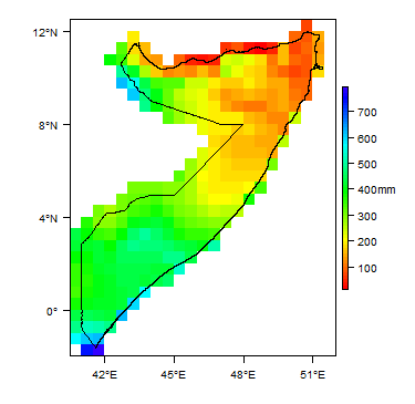
Average Annual Precipitation
-

Average Temperature


Rainfall time-series and graphs of monthly average rainfall and temperature for each individual climate zone can be found on the Somalia Climate Page.


For further detail on the climate datasets used see the climate resources section.
Surface water
| Somalia has two permanent rivers, the Jubba and the Shabele, both of which begin in the Ethiopian Highlands and flow southwards.
|
 |
Soil
| Most of the soils in Somalia have low nutrient and moisture availability, including calcisols, gypsisols, arenosols and solonchak and solonetz type soils that cover much of the country.
The adjacent map shows data from the Soil Map of Africa, available from the European Soil Portal; other soil data are available from the FAO Soils Portal
|
 |
Land cover
| The far north of Somalia is desert or semi-desert, with semi-arid land showing sparse vegetation through much of the north and centre, and grassland and sparse forest throughout much of the south.
|
 |
Geology
This section provides a summary of the geology of Somalia. More detail can be found in the references listed at the bottom of this page. Many of these references can be accessed through the Africa Groundwater Literature Archive.
The geology map on this page shows a simplified version of the geology at a national scale (see the Geology resources page for more details). The map is available to download as a shapefile (.shp) for use in GIS packages. A more detailed geological map at 1:1,500,000 is also published (see Geology: key references, below).
| Key Formations | Period | Lithology | Structure |
| Quaternary | |||
|---|---|---|---|
| Alluvium | Pleistocene to Holocene/Recent | Older Pleistocene alluvial terrace sediments and Holocene/Recent alluvium, including sandy clay with lenses of sand and fine gravel to coarse gravels and boulders.
In some areas fine sands, forming dunes, occur; as do red soils; and calcretes. |
Thickness ranges from several metres to a few tens of metres |
| Volcanic basaltic rocks | Pleistocene | These basaltic lavas were deposited in different periods. They followed existing topographical depressions and uneven basin floors. Several lava flows have tuff intercalations in some places.
form a cover |
Thickness ranges from a few metres to over 50 m |
| Tertiary sedimentary | |||
| Daban Series; Hafun Series and Iskushuban Formation | Tertiary (Oligocene to Miocene) | Thick, extensive, complex series of sedimentary rocks: sandstone, conglomerate, gypsum and siltstone. | 500 m to over 2000 m thick |
| Auradu Formation; Taleex Formation; Karkar Formation | Tertiary (Eocene) | Limestone and evaporitic rocks. The Auradu Formation is limestone; the Taleex Formation has evaporitic rocks - gypsum and anhydrite; and the Karkar Formation is limestones. The limestones can be karstic. | Average thicknesses of the formations are: Karkar - 300 m; Taalex - 250 m; and Auradu - 200-400 m |
| Mesozoic sedimentary | |||
| Cretaceous | Nubian sandstones and thin limestones | From 100 m to over 1000 m thick | |
| Hamanlei Formation | Jurassic | Marine limestones, shales and sandstones. Limestones are karstic. | Thickness varies, mainly due to lateral facies change, from 220 m (at Gowan) to 1000 m (at Bixinduule, between Sheekh and Berbera) |
| Precambrian Basement Complex | |||
| Precambrian | Metamorphic schists, orthogneisses, quartzites and paragneisses, intruded by granites, diorites and gabbros. | Thousands of metres thick | |
Hydrogeology
This section provides a summary of the hydrogeology of the main aquifers in Somalia. More information is available in the references listed at the bottom of this page. Many of these references can be accessed through the Africa Groundwater Literature Archive. The hydrogeology map on this page shows a simplified version of the type and productivity of the main aquifers at a national scale (see the Aquifer properties resource page for more details). The map is available to download as a shapefile (.shp) for use in GIS packages.
File:Somalia Hydrogeology.png

Unconsolidated
| Named Aquifers | General Description | Water quantity issues | Water quality issues | Recharge |
Sedimentary - Intergranular Flow
| Named Aquifers | General Description | Water quantity issues | Water quality issues | Recharge |
Sedimentary - Intergranular & Fracture Flow
| Named Aquifers | General Description | Water quantity issues | Water quality issues | Recharge |
Sedimentary - Fracture Flow
| Named Aquifers | General Description | Water quantity issues | Water quality issues | Recharge |
Basement
| Named Aquifers | General Description | Water quantity issues | Water quality issues | Recharge |
Groundwater Status
Groundwater quantity
Groundwater quality
Groundwater use and management
Groundwater use
Groundwater management
Groundwater monitoring
Transboundary aquifers
For further information about transboundary aquifers, please see the Transboundary aquifers resources page
References
The following references provide more information on the geology and hydrogeology of Somalia. These, and others, can be accessed through the Africa Groundwater Literature Archive
Geology: key references
Abbate E, Sagri M & Sassi FP (with the collaboration of Aden IH, Arush MA, Yusuf OS). 1994. The geological map of Somalia 1:1,500,000. University of Florence, SELCA, Florence
Hydrogeology: key references
Faillace C, Faillace ER. 1986. Water quality data book of Somalia. Hydrogeology and water quality of northern Somalia, Vol. 1, Text. GTZ & WDA, Rosdorf
FAO/SWALIM. 2011. Water sources inventory for northern Somalia, Technical Report No. W-12, January 2009, Nairobi
FAO-SWALIM (Balint Z, Stevanovic Z, Gadain H et al.). 2012. Hydrogeological Survey and Assessment of Selected Areas in Somaliland and Puntland. Technical Report No. W-20, FAO-SWALIM (GCP/SOM/049/EC) Project, Nairobi, Kenya. https://www.faoswalim.org/content/w-20-hydrogeological-survey-and-assessment-selected-areas-somaliland-and-puntland-report-no
GKW. 1977. Water resource development project in Somalia. New water supply system in Burco, Hydrogeological Report, Mannheim
Humphreys H & Sons. 1960. Hargeysa water supply investigation. Westminster and Nairobi.
Macfadyen WA. 1951. Water supply and geology of parts of British Somaliland. Hargeysa
Petrucci B. 2007. Rehabilitation and improvement of Hargeysa urban water supply system. Hydrogeological Monitoring. Final report, January 2007, Water & Land, Hargeysa
Popov AP, Kidwai AL and Karrani SA. 1973: Mineral and ground water survey (Phase II), ground water in the Somali Democratic Republic. Vol. III - Technical Report, UNDP, New York
SHAAC Co. 2006. 13 sites, Hydrogeological site investigation report, UNDP, New York SOGREAH, 1982/83: North-West region agricultural development project. Technical Report 16, Hydrogeology, Grenoble
UNICEF. 1983-1986. Rural water supply and sanitation programme in the Northern Regions", Internal Reports, Hargeysa
Water Supply Survey Team of the People's Republic of China. 1983. Survey report on the possibility of the second water source of Hargeysa City of Somali Democratic Republic, Beijing
Wilson G. 1958. Ground water geology in Somalia, Mogadishu
Return to the index pages
Africa Groundwater Atlas >> Hydrogeology by country >> Hydrogeology of Somalia