Hydrogeology of South Africa: Difference between revisions
No edit summary |
|||
| Line 154: | Line 154: | ||
The hydrogeology map on this page shows a simplified version of the type and productivity of the main aquifers at a national scale (see [[Aquifer properties| the Aquifer properties resource page]] for more details). ''The map is available to download as a shapefile (.shp) for use in GIS packages.'' | The hydrogeology map on this page shows a simplified version of the type and productivity of the main aquifers at a national scale (see [[Aquifer properties| the Aquifer properties resource page]] for more details). ''The map is available to download as a shapefile (.shp) for use in GIS packages.'' | ||
Many other hydrogeological and groundwater resource maps are available, including the Hydrogeological Map Series of 21 hydrogeological maps at 1:500,000 scale produced by the Department of Water Affairs, which covers the whole country. These show aquifer type (e.g. intergranular or fractured) and median borehole yield, with geology, rainfall and other information (Cobbing 2011). These are available to purchase as hard copies from the [https://www.dwa.gov.za/Groundwater/maps.aspx Department of Water Affairs]. | |||
[[File:South Africa_Hydrogeology.png| center | border | 500px]] [[File: Hydrogeology_Key.png |center|500px]] | [[File:South Africa_Hydrogeology.png| center | border | 500px]] [[File: Hydrogeology_Key.png |center|500px]] | ||
| Line 224: | Line 226: | ||
===[[Groundwater management]]=== | ===[[Groundwater management]]=== | ||
The Water Act (Act 36 of 1998) recognised groundwater as a common asset. | |||
The National Environmental Management Act of 1998 and the Minerals and Petroleum Resources Development Act of 2002 make new legal obligations for the mining and other industries in terms of the monitoring and remediation of pollution of water resources, including groundwater (Cobbing 2011). | |||
The South Africa Department of Water Affairs stores groundwater data in a database called the National Groundwater Archive (NGA), which in 2011 contained about 250,000 boreholes records (Cobbing 2011). Another database, the Water Authorisation and Use database, stores information on volumes of groundwater used, based mainly on licensed volumes (Cobbing 2011). | |||
===Groundwater monitoring=== | ===Groundwater monitoring=== | ||
Revision as of 16:12, 17 June 2015
Africa Groundwater Atlas >> Hydrogeology by country >> Hydrogeology of South Africa
Authors
Brighid Ó Dochartaigh, Kirsty Upton, British Geological Survey, UK
Geographical Setting

General
| Estimated Population in 2013* | 52,980,000 |
| Rural Population (% of total) (2013)* | 36% |
| Total Surface Area* | 1,213,090 sq km |
| Agricultural Land (% of total area) (2012)* | 79% |
| Capital City | Pretoria (executive); Bloemfontein (judicial); Cape Town (legislative) |
| Region | Southern Africa |
| Border Countries | Namibia, Botswana,Zimbabwe, Mozambique, Swaziland, Lesotho. |
| Annual Freshwater Withdrawal (2013)* | 12.500 Million cubic metres |
| Annual Freshwater Withdrawal for Agriculture (2013)* | 63% |
| Annual Freshwater Withdrawal for Domestic Use (2013)* | 31% |
| Annual Freshwater Withdrawal for Industry (2013)* | 6% |
| Rural Population with Access to Improved Water Source (2012)* | 88% |
| Urban Population with Access to Improved Water Source (2012)* | 99% |
* Source: World Bank
Climate
-
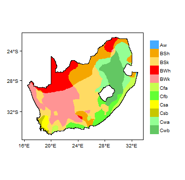
Koppen Geiger Climate Zones
-
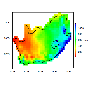
Average Annual Precipitation
-

Average Temperature


Temporal variations in temperature and rainfall. Rainfall time-series and graphs of monthly average rainfall and temperature for each individual climate zone can be found on the South Africa Climate Page.


For further detail on the climate datasets used see the climate resources section.
Climate zones
Surface water
|
|
 |
Soil
 |
Land cover
Geology
This section provides a summary of the geology of South Africa. More detail can be found in the references listed at the bottom of this page. Many of these references can be accessed through the Africa Groundwater Literature Archive.
The geology map on this page shows a simplified version of the geology at a national scale (see the Geology resources page for more details). The map is available to download as a shapefile (.shp) for use in GIS packages.

| Key Formations | Period | Lithology | Structure |
| Geological Environment 1 | |||
|---|---|---|---|
| Name of formation1 | Time period | Description | Structure |
| Geological Environment 2 | |||
| Geological Environment 3 | |||
Hydrogeology
This section provides a summary of the hydrogeology of the main aquifers in South Africa. More information is available in the references listed at the bottom of this page. Many of these references can be accessed through the Africa Groundwater Literature Archive.
The hydrogeology map on this page shows a simplified version of the type and productivity of the main aquifers at a national scale (see the Aquifer properties resource page for more details). The map is available to download as a shapefile (.shp) for use in GIS packages.
Many other hydrogeological and groundwater resource maps are available, including the Hydrogeological Map Series of 21 hydrogeological maps at 1:500,000 scale produced by the Department of Water Affairs, which covers the whole country. These show aquifer type (e.g. intergranular or fractured) and median borehole yield, with geology, rainfall and other information (Cobbing 2011). These are available to purchase as hard copies from the Department of Water Affairs.


Unconsolidated
| Named Aquifers | General Description | Water quantity issues | Water quality issues | Recharge |
Sedimentary - Intergranular Flow
| Named Aquifers | General Description | Water quantity issues | Water quality issues | Recharge |
Sedimentary - Intergranular & Fracture Flow
| Named Aquifers | General Description | Water quantity issues | Water quality issues | Recharge |
Sedimentary - Fracture Flow
| Named Aquifers | General Description | Water quantity issues | Water quality issues | Recharge |
Basement
| Named Aquifers | General Description | Water quantity issues | Water quality issues | Recharge |
Groundwater Status
Groundwater use and management
Groundwater use
Groundwater management
The Water Act (Act 36 of 1998) recognised groundwater as a common asset.
The National Environmental Management Act of 1998 and the Minerals and Petroleum Resources Development Act of 2002 make new legal obligations for the mining and other industries in terms of the monitoring and remediation of pollution of water resources, including groundwater (Cobbing 2011).
The South Africa Department of Water Affairs stores groundwater data in a database called the National Groundwater Archive (NGA), which in 2011 contained about 250,000 boreholes records (Cobbing 2011). Another database, the Water Authorisation and Use database, stores information on volumes of groundwater used, based mainly on licensed volumes (Cobbing 2011).
Groundwater monitoring
For further information about transboundary aquifers, please see the Transboundary aquifers resources page
References
The following references provide more information on the geology and hydrogeology of South Africa.
These, and others, can be accessed through the Africa Groundwater Literature Archive EDIT THE LINK TO CORRECT COUNTRY!!
Geology: key references
Hydrogeology: key references
Return to the index pages
Africa Groundwater Atlas >> Hydrogeology by country >> Hydrogeology of COUNTRY