Hydrogeology of South Africa
Africa Groundwater Atlas >> Hydrogeology by country >> Hydrogeology of South Africa
Contributers
Brighid Ó Dochartaigh, Kirsty Upton, British Geological Survey, UK
Ernst Bertram, Department of Water and Sanitation, South Africa
Kevin Pietersen, SLR Consulting (Pty) Ltd, South Africa
Tamiru Abiye, Wits University, South Africa
Geographical Setting

General
| Estimated Population in 2013* | 52,980,000 |
| Rural Population (% of total) (2013)* | 36% |
| Total Surface Area* | 1,213,090 sq km |
| Agricultural Land (% of total area) (2012)* | 79% |
| Capital City | Pretoria (executive); Bloemfontein (judicial); Cape Town (legislative) |
| Region | Southern Africa |
| Border Countries | Namibia, Botswana,Zimbabwe, Mozambique, Swaziland, Lesotho. |
| Annual Freshwater Withdrawal (2013)* | 12.500 Million cubic metres |
| Annual Freshwater Withdrawal for Agriculture (2013)* | 63% |
| Annual Freshwater Withdrawal for Domestic Use (2013)* | 31% |
| Annual Freshwater Withdrawal for Industry (2013)* | 6% |
| Rural Population with Access to Improved Water Source (2012)* | 88% |
| Urban Population with Access to Improved Water Source (2012)* | 99% |
* Source: World Bank
Climate
-
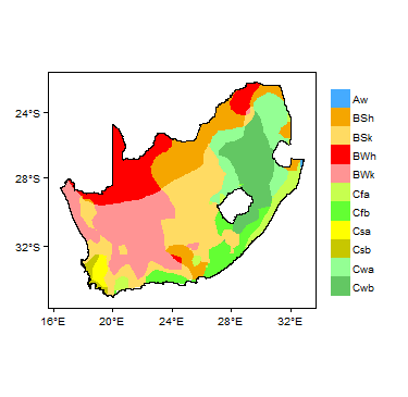
Koppen Geiger Climate Zones
-
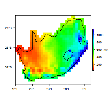
Average Annual Precipitation
-

Average Temperature


Temporal variations in temperature and rainfall. Rainfall time-series and graphs of monthly average rainfall and temperature for each individual climate zone can be found on the South Africa Climate Page.


For further detail on the climate datasets used see the climate resources section.
Climate zones
Surface water
|
|
 |
Soil
 |
Land cover
Geology
This section provides a summary of the geology of South Africa. More detail can be found in the references listed at the bottom of this page. Many of these references can be accessed through the Africa Groundwater Literature Archive.
The Council for Geoscience publishes a simplified geological map of South Africa, available to download as a graphics file.
The following general geological environments are seen in South Africa (after Pietersen):
| Period | Brief description | ||
| Unconsolidated deposits | |||
|---|---|---|---|
| Quaternary - Tertiary | Including Kalahari aeolian sands; and alluvial deposits in river valleys. | ||
| Sedimentary rocks | |||
| Carboniferous to Triassic | Karoo Supergroup. Consists mainly of sandstone, mudstone, shale and siltstone. | ||
| Ordovician to Devonian | Table Mountain Group and similar geological units. Dominantly arenitic, quartzitic sandstones. | ||
| Volcanic rocks | |||
| Including basalts of the Karoo Supergroup. | |||
| Intrusive igneous rocks | |||
| Largely granitic rocks. | |||
| Basement | |||
| Precambrian | Crystalline metamorphic and igneous rocks. | ||
Hydrogeology
This section provides a summary of the hydrogeology of the main aquifers in South Africa. More information is available in the references listed at the bottom of this page. Many of these references can be accessed through the Africa Groundwater Literature Archive.
Many hydrogeological and groundwater resource maps are available for South Africa. In particular, these include the Hydrogeological Map Series of 21 hydrogeological maps at 1:500,000 scale produced by the Department of Water Affairs, which covers the whole country. These show aquifer type (e.g. intergranular or fractured) and median borehole yield, with geology, rainfall and other information. These are available to purchase as hard copies from the Department of Water Affairs. A hydrogeological map of the whole of South Africa, at 1:2,000,000 scale, also published by DWAF, is available to view on the WHYMAP website.
A SADC mapping programme produced a Regional Hydrogeological Map for the SADC region ( SADC HGM 1 2010).
The DWAF produces a set of national groundwater maps including an aquifer classification map, groundwater quality map, and aquifer vulnerability map.
Summary
Most aquifers in South Africa are in fractured rock domains. Most research has focussed on the main Karoo Basin aquifer and the dolomite aquifers. There is still much to learn about the hydrogeology of many of South Africa's aquifers (Pietersen).
Dominantly Unconsolidated
| Named aquifers | Summary |
| Coastal sand, gravel and other unconsolidated sediments; alluvial sand and gravel in river valleys | Typically shallow and unconfined. Usually less than 30 m thick. Typical yields in alluvial deposits are 3 to 8 l/s; typical yields in coastal sands are 3 to 16 l/s (Pavelic et al. 2012). Recharge rates are generally high. The aquifers are highly vulnerable. |
Sedimentary - Intergranular & Fracture Flow
| Named aquifers | Summary |
| Karoo Supergroup | An important aquifer in South Africa. Typically low permeability, particularly fine grained shale, mudstone and similar layers, in which groundwater flow is largely via fractures and other discontinuities, and storage capacity is limited (Pietersen). Sandstone layers typically have dual permeability and have better groundwater potential. Pavelic et al. (2012) state that overall, the Karoo forms low to moderately productive aquifers, with typical borehole yields 1 to 3 l/s.
Groundwater quality is variable. Most groundwaters have total dissolved solids (TDS) values between 450 and 1000 mg/l, with the highest values in the west and south of the basin (Pietersen). |
| Table Mountain Group | An important aquifer. Groundwater often at more than 100 m depth; evidence for hot groundwater circulation at depths of up to 2000 m (Pietersen). Groundwater is usually of Na-Cl type, with low pH, low hardness and low dissolved solids (Pietersen). |
Sedimentary - Fracture Flow
| Named aquifers | Summary |
| Dolomite | Very important, particularly in northwest South Africa. The dolomite ranges from 200 to 1900 m thick. Karstic features are developed in the dolomite and they can form high yielding aquifers. Typical borehole yields are 20 to 50 l/s (Pavelic et al. 2012). Dissolution channels developed along fractures can extend to the ground surface, allowing direct recharge and groundwater flow (Pavelic et al. 2012). Vulnerable to pollution, because of thin soil cover and high permeability with rapid fracture flow. |
| Volcanic rocks | Little is known of the groundwater potential of these rocks. |
| Intrusive igneous rocks | Groundwater in these rocks occurs in fractures and weathered zones, both of which are often associated with major stuctural features, such as folds and faults; or with dykes. Water-bearing features are best developed in the uppermost few tens of metres. Groundwater quality is often affected by elevated fluoride (Pietersen). |
Basement
| Named aquifers | Summary |
| Crystalline metamorphic and igneous rocks | In these rocks, groundwater is found in the shallow weathered (regolith) zone in the uppermost few tens of metres of the rock - usually to a maximum of around 50 m depth (Pietersen) - and/or in deeper fracture zones. Aquifer properties depend on the development of fractures and weathering. They generally form low productivity, local aquifers, with limited storage capacity. Borehole yields are typically low. Where they are overlain by unconsolidated aquifers, such as alluvium, groundwater in both aquifers can be hydraulically connected, increasing storage and groundwater potential.
Groundwater quality is partially controlled by the products of weathering and by length of residence time, with groundwater in shallow, active aquifers typically having lower levels of mineralisation than deeper, slower circulating aquifer systems. Groundwater is dominantly of Na-Cl type. Nitrate concentrations can be elevated due to natural factors (Pietersen). |
Groundwater Status
Groundwater use and management
Groundwater use
Groundwater management
Groundwater resources in South Africa were originally studied by the hydrogeologists of the Geological Survey, now the Council for Geosciences. The Department of Water Affairs and Forestry (DWAF), the Water Resources Commission (WRC), and to a lesser extent the Council for Scientific and Industrial Research (CSIR) have produced major studies of groundwater conditions in South Africa.
DWAF is the main implementer of the National Water Act, and through the Directorate of Surface and Groundwater Information, is responsible for, among other things, groundwater data acquisition and management and the development and maintenance of the main groundwater information systems for South Africa; carrying out regional monitoring; directing and carrying out groundwater resource assessments and exploration, including drilling; and evaluation and recommendations for water licensing.
The DWAF publish many reports and other documents relating to groundwater, including water resources status reports, and guidelines and standards for the development and management of groundwater. These can be accessed through the DWAF website. One of these is the Groundwater Strategy 2010 report (2010).
The DWAF maintains an online National Groundwater Archive, with information on thousands of boreholes including, where available, lithological, borehole construction, groundwater level and groundwater quality information.
Legislation
The National Water Act (Act 36 of 1998) recognised groundwater as a common asset (DWA 2010).
The National Environmental Management Act of 1998 and the Minerals and Petroleum Resources Development Act of 2002 make new legal obligations for the mining and other industries in terms of the monitoring and remediation of pollution of water resources, including groundwater (DWA 2010). Further protocols, strategies and standards are listed in DWA 2010
The South Africa Department of Water Affairs stores groundwater data in a database called the National Groundwater Archive (NGA), which in 2010 contained about 250,000 groundwater source records (DWA 2010). Another database, the Water Authorisation and Use database, stores information on volumes of groundwater used, based mainly on licensed volumes (DWA 2010).
Groundwater monitoring
For further information about transboundary aquifers, please see the Transboundary aquifers resources page
References
The following references provide more information on the geology and hydrogeology of South Africa.
They, and many others, can be accessed through the Africa Groundwater Literature Archive.
The Water Research Commission (WRC) maintains the Knowledge Hub, a major online searchable archive of reports and other documents relating to water in South Africa.
Useful web resources
Department for Water Affairs and Forestry - Groundwater. https://www.dwaf.gov.za/groundwater/
Water Research Commission. https://www.wrc.org.za/
Council for Scientific and Industrial Research. https://www.csir.co.za/
Published literature
Council for Geoscience. 2003. Simplified Geology of South Africa, Lesotho and Swaziland. Map compiled by CJ Vorster.
DWA. 2010. Groundwater Strategy 2010. Department of Water Affairs, South Africa.
Pavelic P, Giordano M, Keraita B, Ramesh V and Rao T (eds.). 2012. Groundwater availability and use in Sub-Saharan Africa: a review of 15 countries. IWMI, Sri Lanka, 2012.
Pietersen K. Appendix B: A review of groundwater resources of South Africa.
SADC HGM 1. 2010. Technical Assistance to the SADC - 'SADC Hydrogeological Mapping Project' (9 ACP RPR 39-89); Final Report. Southern African Development Community European Development Fund, March 2010; a technical report to the Southern African Development Community (SADC) and Cooperating Partners: European Union and GTZ.
Return to the index pages
Africa Groundwater Atlas >> Hydrogeology by country >> Hydrogeology of COUNTRY