Hydrogeology of Zimbabwe
Africa Groundwater Atlas >> Hydrogeology by country >> Hydrogeology of Zimbabwe
Authors
Daina Mudimbu, Geology Department, University of Zimbabwe, P.O Box MP167, Mt Pleasant, Harare, Zimbabwe
Dr Richard Owen, Geology Department, University of Zimbabwe, P.O Box MP167, Mt Pleasant, Harare, Zimbabwe
Geographical & Political Setting

General
| Estimated Population in 2013* | 14149648 |
| Rural Population (% of total)* | 67.4% |
| Total Surface Area* | 386850 sq km |
| Agricultural Land (% of total area)* | 41.9% |
| Capital City | Harare |
| Region | Eastern Africa |
| Border Countries | Mozambique, South Africa, Botswana, Namibia, Zambia |
| Annual Freshwater Withdrawal (2013)* | 4205 Million cubic metres |
| Annual Freshwater Withdrawal for Agriculture* | 78.9% |
| Annual Freshwater Withdrawal for Domestic Use* | 14.0% |
| Annual Freshwater Withdrawal for Industry* | 7.1% |
| Rural Population with Access to Improved Water Source* | 68.7% |
| Urban Population with Access to Improved Water Source* | 97.3% |
* Source: World Bank
Climate
Broad description of Zimbabwe – major topographical/geographical features e.g. mountain ranges, deserts, coastal areas etc...
Climate classification of Zimbabwe. Spatial variations in annual average rainfall and temperature.
-
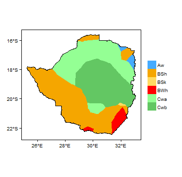
Koppen Geiger Climate Zones
-

Average Annual Precipitation
-

Average Temperature


Temporal variations in temperature and rainfall.
Rainfall time-series and graphs of monthly average rainfall and temperature for each individual climate zone can be found on the Zimbabwe Climate Page.


For further detail on the climate datasets used see the climate resources section.
Surface water
| General information about Zimbabwe surface water – perennial/ephemeral – major rivers – discharge points.
Additional information from country authors...
|
 |
Soil

|
General information about Zimbabwe soils. |
Land cover
| General information about Zimbabwe land cover.
|
 |
Geology
The following section provides a summary of the geology of Zimbabwe. More detailed information can be found in the key references listed below: many of these are available through the Africa Groundwater Literature Archive.
The geology map below was created for this Atlas. It shows a simplified version of the geology of Zimbabwe at a national scale. The map is available to download as a shapefile (.shp) for use in GIS packages.
| Key Formations | Period | Lithology | Structure |
| Unconsolidated Sedimentary | |||
|---|---|---|---|
| Pleistocene | Unconsolidated sequence of clay, sand and gravel of varying thickness in the river valleys. | In Sabi Valley reported thicknesses of up to 70-80 m of alluvium are present and 45 m in the Zambezi Valley. Elsewhere the unconsolidated deposits are generally less than 25 m thick. | |
| Sedimentary Kalahari Basin | |||
| Lower Pipe Sandstone and the Kalahari Sand. | Tertiary and Quaternary | The Pipe Sandstone is in places unconsolidated or weakly cemented by silica and traversed by numerous hollow pipes. It is composed of buff or pink sands. In places it is cemented into a hard secondary quartzite or silcrete. The Kalahari Sand comprises pink or buff coloured, structureless, aeolian sand with a high proportion of fine silt. | Approximately 44000 km² of western Zimbabwe is covered by unconsolidated Kalahari Sands. In places, the thickness of the sand is in excess of 100 m. |
| Sedimentary – Cretaceous-Tertiary | |||
| Cretaceous-Tertiary | Mudstone, arkose, grit conglomerate and sandstone bands | ||
| Igneous Largely Volcanic | |||
| Upper Karoo Batoka Basalts | Triassic | The Batoka basalts comprise amygdaloidal lava flows with interbedded tufa horizons. | |
| Sedimentary – Mesozoic-Palaeozoic (Upper and Lower Karoo) | |||
| Upper and Lower Karoo | Carboniferous - Permian | These arenaceous and argillaceous sequences are conventionally sub-divided into the Upper and Lower Karoo. The Upper Karoo comprises the Forest Sandstone and the Escarpment Grit, while the Lower Karoo consists of the Madumabisa Mudstone, and the Upper and Lower Wankie Sandstone.
This thick series of alternating sandstones, siltstones and mudstone is overlain by the Karoo basalt. |
|
| Igneous intrusive (Great Dyke) | |||
| Great Dyke | Late Precambrian | The Great Dyke is a large linear mafic-ultramafic intrusive feature composed of norite, gabbro and anorthosite. | Up to 1000 m thick |
| Precambrian calcareous metasediments and quartzite | |||
| In the south-east of Kariba, sedimentary, calcareous and metamorphic rocks of the Deweras, Lomagundi and Piriwiri (all part of the Magondi orogenic belt), Sijarira and Tengwe River Groups. The Umkondo Group | Mid to Late Precambrian (Proterozoic) | Phyllites with subordinate quartzite of the Piriwiri Formation. slates and shales with minor quartzite of the Lomagundi Formation, shales of the Tengwe River Group and shales, siltstone and fine grained sandstone of the Sijarira Group.
These rocks include shales, phyllites, quartzites, siltstones, sandstones, conglomerates, limestones and dolomites as well as basic metavolcanics. |
|
| Precambrian Craton - Metavolcanics and Metasediments (Greenstone Belts) | |||
| Greenstones made up of the supergroups of the Sebakwean, Belingwean, Bulawayan and Shamvaian | Early Precambrian / Archaean | Irregularly shaped bodies of greenstone material (also known as gold-belts). The Greenstone Belts comprise metavolcanics and metasediments. | Moderate to deep weathering occurs within the Greenstone Belts. |
| Precambrian Craton (Granites, gneisses and mobile belt gneisses) | |||
| The Basement Complex Granitoids, and Mobile/orogenic Belts (Limpopo and Zambezi). | Archaean | The Basement Complex occupies a large portion of central Zimbabwe and is characterised by vast areas of gneissose rocks, into which younger granite bodies of various sizes were intruded. These intrusive rocks include younger Proterozoic granites and granodiorite, adamellite and tonalite of the Younger Intrusive Granites.
The Limpopo and Zambezi Mobile Belts are zones of deformed and metamorphosed rocks which run SSW-NNE in the south of the country and NW-SE across the north of Zimbabwe and into Zambia respectively. They comprise paragneisses and anorthosite gneisses. There are additional lineaments formed by dolerites and sheets of dolerite composition. |
Erosional surfaces distinguish the general thickness of the weathering in this unit which ranges from greater than 30 to 35 m on the African erosional surface to shallow and less than 30 m on the Post African and Pliocene/Quaternary surfaces. |
Hydrogeology
This section will contain a broad overview of the hydrogeology.
Aquifer properties
File:Zimbabwe Hydrogeology.png 
Unconsolidated
| Named Aquifers | General Description | Water quantity issues | Water quality issues | Recharge |
| Save Alluvial Aquifer, Umzingwane Alluvial aquifer, Grootvlei/Limpopo (transboundary), Kalahari Sand Aquifer | The Kalahari Sands and various alluvial deposits across the country form unconfined aquifers.
Alluvial deposits are only locally developed within Zimbabwe with the largest occurrences found in the Save (Sabi)- Limpopo river system and major tributaries, along the Zambezi and along the Munyati and Sessami rivers in the north-west. The alluvial deposits vary in thickness, being generally less than 25 m in most areas, but as much as 45 m in the Zambezi Valley and up to 70 m in the Sabi Valley. The Kalahari Sands are mainly unconsolidated but also contain the consolidated Pipe Sandstone. The aquifer properties of the Kalahari Sands and Alluvial Deposits are extremely variable and may range from locally low to locally high average hydraulic conditions. The water table is generally over 20 m deep. Boreholes in the alluvial deposits are typically 20 – 70 m deep, and provide yields of 100-5000 m3/d. Boreholes in the Kalahari Sands are commonly 70 – 100 m deep, and provide yields of 100-1000 m3/d. |
These aquifers have high groundwater development potential. | Water quality is generally good. Lenses of brackish water occur in the alluvium of the Sabi river, which may be fossil water and/or water recharging via the adjacent Karoo strata. |
Consolidated Sedimentary - Intergranular Flow
| Named Aquifers | General Description | Water quantity issues | Water quality issues | Recharge |
| Cretaceous-Tertiary sedimentary strata | The aquifer properties of these sedimentary rocks are controlled by primary porosity and permeability. The more favourable horizons are the conglomerates and cleaner sandstones, and in the vicinity of rivers.
Water tables are typically less than 15 m deep, and boreholes are usually drilled to 70 – 100 m depth. Transmissivity is usually less than 1.5 m2/d, and specific capacity below 10 m3/d/m. |
Water quality is moderate to good with total dissolved solids (TDS) concentrations ranging from less than 1000 mg/l to 2000mg/l. Water poses potential encrustation hazard. |
Igneous - Fracture Flow
| Named Aquifers | General Description | Water quantity issues | Water quality issues | Recharge |
| Igneous – largely volcanic | Aquifers in the volcanic igneous rocks are limited to discrete zones of weathering, fracturing and jointing and contact zones with underlying Forest Sandstone and Interbedded Sandstone. Wide sheets of basalt occur in the Victoria Falls and Nyamamdhlovu, and Beitbridge and Chiredzi areas with numerous smaller remnants forming high lying cappings in the Gokwe area.
These aquifers are unconfined, have variable transmissivity from about 9 – 90m2/d and specific capacity of the order of 1-10 m3/d/m. The water table is usually less than 15 m depth, and borehole depths average 50 m, varying from about 40 to 60 m. Borehole yields vary from 10 to 250 m3/d. |
This aquifer has moderate groundwater development potential. | The quality of the groundwater in this unit is good, with total dissolved solids (TDS) concentrations normally below 1000 mg/l. There is no identified fluoride hazard, although it may pose a mild encrustation hazard in places. |
Consolidated Sedimentary - Intergranular & Fracture Flow
| Named Aquifers | General Description | Water quantity issues | Water quality issues | Recharge |
| Nyamandhlovu Forest Sandstone aquifers (Karoo) | The Forest Sandstone is widely developed in the Hwange – Zambezi Basin and constitutes an important regional aquifer. These aquifers are mainly confined, being unconfined only close to outcrop.
The Escarpment Grit also comprises a confined aquifer in the Hwange and Save -Limpopo basin. The Madumabisa Mudstone is associated with shallow weathering, but has low groundwater development potential. The Upper and Lower Hwange Sandstone is widespread in the Karoo basin; it is found at depth and the aquifer is always confined. The hydraulic conductivity and specific yield range from 0.1 to 2.09 m/d and 0.02 to 0.11, respectively. In the Forest Sandstone, boreholes are typically 30 – 100 m deep, with water levels sometimes less than 10 m depth but more commonly greater than 20 m depth. In the Escarpment Grit and Madumabisa Mudstone, boreholes are typically 30 – 100 m deep, with water levels about 10 – 15 m and greater than 20 m depth respectively. Boreholes are usually 100 – 150 m deep in the Upper and Lower Hwange Sandstones. Borehole yields are lowest in the Madumabisa Mudstone (10 - 25 m3/d) and groundwater occurrence is rare, only occurring in the vicinity of rivers. In the other units, borehole yields range between 50 – 500 m3/d. |
This aquifer has high groundwater development potential. | Water quality in the Forest Sandstone is generally good with total dissolved solids (TDS) concentration below 1000 mg/ l. There is no recognised fluoride threat, although it may pose a mild encrustation hazard. | In the Nyamandlovu Forest Sandstone recharge estimates indicate an annual recharge of 105.5 mm with 38.4%, 52.1% and 9.5% accounting respectively for direct recharge, water mains and sewer leakages. (1Rusinga F. and Taigbenu A. E. Groundwater resource evaluation of urban Bulawayo aquifer. Water SA Vol. 31 No. 1 January 2005. ISSN 0378-4738) |
Consolidated Sedimentary – Fracture flow (including karst development)
| Named Aquifers | General Description | Water quantity issues | Water quality issues | Recharge |
| Lomagundi Dolomite | Some water-bearing horizons exist within the rocks mapped as Precambrian calcareous metasediments and quartzite. Aquifers exist primarily due to karst features in the calcareous rocks of the Tengwe River and Lomagundi Formations (massive dolomites and limestones). Karst features are thought to be developed to an average depth of approximately 60 -70 m. Weathering of shaley horizons in the limestones also increases the potential for groundwater storage and flow.
The groundwater development potential of the Lomagundi Dolomite is classified as high, and that of the Tengwe River Limestone as moderate. Measurements of the specific capacity of boreholes in these formations have given the following values:
Water levels tend to be generally shallow (±10m) in the area of Tengwe limestone/shaley limestone, while in the Lomagundi Dolomite the water level varies from ground level at spring occurrences to 50 m depth, depending on land use (commercial or subsistence farming). Typical borehole depths are 50 – 70 m in the Tengwe River Formation and 60 – 80 m in the Lomagundi Formations. Yields of 500 - >2000 m3/d are possible. |
The water quality is generally very good with a slightly hard calcium/magnesium character. |
Basement
| Named Aquifers | General Description | Water quantity issues | Water quality issues | Recharge |
| The gneissose rocks and intrusive granites are devoid of any primary porosity, so the aquifer properties of these basement rocks are controlled by the degree of secondary porosity and permeability, often associated with fracturing, jointing, schistosity planes and weathering. Two hydrogeological sub-units are recognized, each with characteristic groundwater occurrence: the granite and gneiss below the African erosion surface; and the granite and gneiss below the Post-African and Pliocene Quaternary erosion surfaces.
Granite and gneiss below the African erosion surface Rocks beneath the African erosion surface have relatively well developed hydraulic properties resulting from extensive weathering, which generally exceeds 30 - 35 m in depth. Aquifer thickness is about 30 to 50 metres; boreholes are usually drilled to 40 – 50 m depth. Sustainable borehole yields are in the region of 50 - 100 m3/d. Here, transmissivity is low to moderate (<10m2/d) and specific capacity is moderate (30-50 m3/d/m). Granite and gneiss below the Post-African and Pliocene Quaternary erosion surfaces The hydraulic properties of the rocks beneath the Post-African and Pliocene-Quaternary erosion surfaces are considerably less well developed. Areas of weathering tend to be patchy and shallow (10 - 30 m). Aquifer thickness is about 10 to 30 m, often less than 15 m. Boreholes are typically 30 – 40 m depth. The transmissivity of these rocks is low (1 – 10 m2/d), while boreholes have low to moderately low specific capacity of the order 2 – 20 m3/d/m. |
Areas of granite and gneiss pavement, very shallow bedrock and inselbergs and other features producing positive relief common in the Post-African and Pliocene/Quaternary surfaces are associated with marginal to nil groundwater resources.
The highest groundwater development potential is found in those areas possessing the deepest and most aerially extensive weathering as in the larger African surface. Chemical weathering along faults, shear zones and dyke contacts may produce equally important water bearing structures. Incorrectly sited boreholes may fail during the dry season. |
Groundwater in the aquifers beneath the African erosion surface is generally of good quality with a total dissolved solids (TDS) concentration below 1000mg/l and no recorded fluoride hazard.
In aquifers associated with the Post-African and Pliocene/Quaternary surface the groundwater quality is generally good. TDS is usually below 1000mg/l, however it is higher in the Beitbridge and Nuanesti area (TDS of 1000 to 2000 mg/l) where there is also a fluoride hazard. |
Recharge |
Groundwater Status
Groundwater quality
As a general comment to the groundwater development of Zimbabwe all the hydrogeological units are equally suitable for the development of single point primary water supplies either by means of dug wells or by boreholes. Furthermore units classified as possessing moderate or high groundwater development potential are capable of supporting extensive exploitation for piped water supplies and irrigation schemes (Interconsult, 1985).
Groundwater quantity
The groundwater quality throughout Zimbabwe is usually good and does not pose any constraint to use for human consumption. Of the constituents that are a threat to health, the few cases of high nitrate are ascribed to poor borehole construction.
High fluoride is found in isolated pockets in the Gokwe area and appear to be associated with the outcrop area of the Wankie Sandstone. At the regional scale, fluoride concentrations are not a constraint to exploitation (Interconsult, 1985).
Groundwater use and management
Groundwater use
According to the 2012 census, about 38% of a total of 3,059,016 Zimbabwean households fetched their water from boreholes and protected wells (Zimbabwe National Statistics Agency, 2012).
“Groundwater in Zimbabwe forms the main source of drinking water in rural areas where about 70% of the population lives” (Sunguro et al, 2000).
In addition to domestic use in rural and urban areas, groundwater supplies agriculture and industry in Zimbabwe.
The total annual abstraction of groundwater in the rural areas, from some 40,000 boreholes, is estimated at 35 x 10 6 m3 and the total groundwater abstraction for the agricultural sector is estimated at 350 x 10 6 m3. Groundwater is also abstracted for emerging towns known as Growth Points (e.g. Gokwe), Urban Centres (e.g. Bulawayo) and Rural Institutions (e.g. schools, health and business centres). Overall, groundwater presently contributes not more than 10% to the total water use in Zimbabwe (Sunguro et al, 2000).
Water is mainly abstracted by boreholes with a hand pump fitted in rural areas, due to limited electrification, while electric pumps are more common in urban areas.
Groundwater management
The Ministry of Environment, Water and Climate Resources is responsible for the formulation and implementation of sustainable policies regarding the development, utilisation and management of water resources in cooperation with user communities and institutions.
The Water Act (1998) established the Zimbabwe National Water Authority (ZINWA), a parastatal tasked with providing a framework for the development, management, utilisation and conservation of the country’s water resources through a coordinated approach. ZINWA has a groundwater branch tasked with specifically looking into the management of the national groundwater resources.
The Water Act also specifies the establishment of Catchment Councils. Seven Catchment Councils were established in the major hydrological zones of the country with functions that included preparing an outline plan for their river systems, determining applications and granting water permits, regulating and supervising the use of water, supervising the performance of functions by Sub-catchment Councils, and dealing with conflicts over water. Water resources include groundwater resources, though due to the limited capacity and lack of adequate information regarding the quantity of groundwater, the management of this resource poses a challenge to the councils.
Recent developments in the major cities of a collapse of the municipal water treatment and distribution systems has seen a shift towards the use of groundwater at household and even industrial levels, with a rise in bulk water suppliers abstracting huge volumes of water from the groundwater resource. This has raised new challenges of conflict over lowering groundwater levels in residential areas which the catchment councils have inadequately capacity to deal with.
In addition to the Water Act (1998), groundwater regulations and guidelines were developed for Zimbabwe in 1999 to control groundwater development and management. The regulations and guidelines compliment the Water Act (1998) and have been formulated within a framework of integrated water resources management (IWRM).
Transboundary aquifers
Summary of transboundary aquifers
Zimbabwe has five transboundary aquifers as detailed by UN-IGRAC, 2012:
- Limpopo Basin (Mozambique, South Africa, Zimbabwe)
- Tuli Karoo Sub-basin (Botswana, South Africa, Zimbabwe)
- Eastern Kalihari Karoo Basin (Botswana, Zimbabwe)
- Nata Karoo Sub-basin (Angola, Botswana, Namibia, Zambia, Zimbabwe)
- Medium Zambezi Aquifer (Zambia, Zimbabwe).
For further information about transboundary aquifers, please see the Transboundary aquifers resources page
Groundwater monitoring
The following summary is taken verbatim from the IGRAC report, “Groundwater Monitoring in the SADC Region” which was prepared for the Stockholm World Water Week in 2013 (IGRAC, 2013).
National groundwater monitoring network
“Groundwater resources management is carried out by the Groundwater Department of the Zimbabwe National Water Authority (ZINWA). ZINWA is a parastatal under the Ministry of Water Resources Development and Management. Monitoring of groundwater level fluctuation is currently confined to only three major aquifers. These are the Lomagundi Dolomite Aquifer situated in the north western part of the country, the Nyamadlovu Sandstone Aquifer situated in the south western part of the country and the Save Alluvial Aquifer located in the south eastern part of the country.
Water levels are measured using data loggers and readings are collected monthly. Chloride deposition has been monitored in six monitoring stations throughout the country but has been discontinued due to lack of funds. The information was used in the assessment of groundwater recharge rates. The Department also used to carry out chemical surveillance on groundwater and surface water but again the programme was suspended due to lack of resources.
Data management and assessment
Groundwater fluctuation levels are recorded on template sheets during the last week of the month by field observers who send the records to the main office in Harare. The data is recorded in Excel and an initial quality control exercise is performed. The data is then reformatted and importated into a national groundwater database called Hydro GeoAnalyst. The software has proven to be quite versatile and meeting the needs of ZINWA. Hydrographs and groundwater maps are produced which assist in overall groundwater development and management.
Challenges
The main challenges encountered relate to lack of financial resources, logistical support and limited staff. Another challenge is related to vandalism of facilities by local communities. In certain instances, monitoring boreholes are clogged with debris making water level recording impossible. Specialised entrances for data loggers and locking mechanisms are currently being manufactured for monitoring boreholes in the Save Alluvial Aquifer. It is desired to revive both the chloride deposition and chemical surveillance programmes and to have telemetric (real time) data collection for the water level fluctuations.” (IGRAC, 2013).
References
Geology: key references
Interconsult. 1985. National Master Plan for Rural Water Supply and Sanitation. Volume 22 Hydrogeology. Ministry of Energy and Water Resources Development, Zimbabwe. https://www.bgs.ac.uk/sadc/fulldetails.cfm?id=ZW2024&country=Zimbabwe
Zimbabwe Surveyor General. 1994. Zimbabwe Geological and Mineral Resources Map, scale 1:1,000,000. Surveyor General, Zimbabwe.
Zimbabwe Geological Survey Bulletins
Hydrogeology: key references
IGRAC. 2013. Groundwater Monitoring in the SADC Region. Accessed at https://www.un-igrac.org/dynamics/modules/SFIL0100/view.php?fil_Id=242 on 09/06/2015.
Interconsult. 1985. National Master Plan for Rural Water Supply and Sanitation. Volume 22 Hydrogeology. Ministry of Energy and Water Resources Development, Zimbabwe. https://www.bgs.ac.uk/sadc/fulldetails.cfm?id=ZW2024&country=Zimbabwe
UN-IGRAC. 2012. Transboundary aquifers of the world, update 2012. 1:50 000 000. Sepcial Edition for the 6th World Water Forum, Marseille.
Other references
Zimbabwe National Statistics Agency. 2012. Zimbabwe Population Census, 2012.
Sunguro, S., Beekman, H. E., Erbel, K., 2000. Groundwater regulations and guidelines: crucial components of integrated catchment management in Zimbabwe. “1st WARFSA/WaterNet Symposium: Sustainable Use of Water Resources; Maputo 1-2 November 2000”.
African Groundwater Literature Archive (AGLA) references
For more references for the hydrogeology of Zimbabwe please visit the African Groundwater Literature Archive's Zimbabwe page.
Jump up to the index pages
Africa Groundwater Atlas >> Hydrogeology by country >> Hydrogeology of Zimbabwe