Marsco, Skye - an excursion
| From: Bell, B.R. and Harris, J.W. An excursion guide to the geology of the Isle of Skye : Geological Society of Glasgow, 1986. © 1986 B.R. Bell & J.W. Harris. All rights reserved. October 2022 note: A new edition of the guide is now available. |


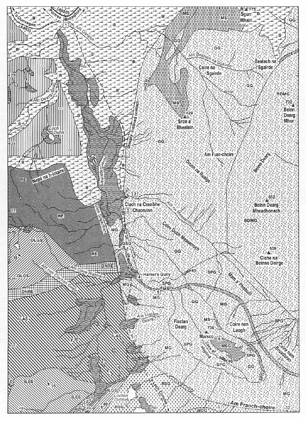
Excursion 15 Marsco (Figure 29)
Purpose: To examine granites and a mixed-magma ring-dyke within the SW part of the Western Red Hills Centre.
Aspects covered: hydrothermally-altered plateau lavas; the Glamaig Granite (normal and marginal facies); basic dykes of the Beinn Dearg Type; the Glen Sligachan Granite; the Southern Porphyritic Granite; the Southern Porphyritic Felsite; ferrodiorite; xenoliths of Lewisian Gneiss within the ferrodiorite intrusion; marscoite (mixed-magma rock); the Marsco Granite; (option: the Marsco Summit Gabbro).
Route: Sligachan–Allt na Measarroch–Clach na Craoibhe Chaoruinn–Harker's Gully (NW side of Marsco)–(option: summit of Marsco–Coire nan Laogh–Mam a' Phobuill–Coire Dubh Measarroch)–Allt na Measarroch–(Sligachan).
Distance: 9 kilometres (Localities 1 to 5 only) or 15 kilometres (Localities 1 to 6).
Time: 5 hours (Localities 1 to 5 only) or 10 hours (Localities 1 to 6).
General comments: During bad weather it is advisable to only undertake Localities 1 to 5. However, on a clear day, the view from the summit of Marsco is worth the extra effort required.
Sligachan lies at the head of Glen Sligachan on the Broadford-Portree (A850) road. It is 26km (16 miles) from Broadford and 14km (9 miles) from Portree. Ample parking for cars, minibuses and coaches is available in this area, for example, on the south side of the road 100m east of the new bridge over the River Sligachan.
Locality 1 [NG 4862 2982]
From the old bridge at Sligachan one of the most spectacular views of the Cuillin and Red Hills is obtained on a clear day. In the immediate area and looking down Glen Sligachan, the flat-lying ground to the south is composed of Lower Tertiary plateau lavas (3D), giving way, at Nead na h-Iolaire, to rocks of the Cuillin Complex (4A). On the east side of the glen granites and associated rocks of the Western Red Hills Centre (6A) crop out. These include: the Glamaig Granite on Druim na Ruaige (6D); the Beinn Dearg Mhor Granite on the summit of that name (6F); and, a sheet of the mixed-magma rock-type, marscoite (6H), forming the crags of Sron a' Bhealain. The distribution of the granites on Marsco is shown in (Figure 7). At the southern end of Glen Sligachan is Meall Dearg, a red hill composed of the Meall Dearg Granite (5C) on the upper slopes and the Ruadh Stac Granite (5D) beneath. Both intrusions are members of the Srath na Creitheach Centre (5A). The irregular ridge of Blaven, marking the eastern margin of the Cuillin Complex (4A), can be seen in the far distance, SE of Marsco. Walk 3km south along the Loch Coruisk path, which starts between the two bridges on the old road, on the east side of the River Sligachan. This river meanders through glacial moraines (11B) which generally obscure much of the underlying geology. Nevertheless, exposures of plateau lava and granite may be examined in the vicinity of the path en route to Marsco.
Locality 2 [NG 4964 2718]
Where the path crosses the Allt na Measarroch, proceed 100m upstream and examine good exposures of the Glamaig Granite (6D) in the stream bed. This granite is composed of equigranular crystals of quartz, alkali feldspar and plagioclase, together with hornblende and biotite. It is readily distinguished from other acid intrusions within the Western Red Hills Centre by the presence of numerous small (5–50mm), rounded to sub-angular, mafic inclusions. Further details of this granite, plus a discussion on the possible origin and significance of the mafic inclusions, are presented in Section (6D) of Chapter 6. Alkali olivine dolerite dykes of the Beinn Dearg Type ((9B) , (9C) ) cut this granite and crop out further upstream (400–500m). These dykes may also be examined when traversing the Coire Dubh Measarroch, upon returning from the summit of Marsco (Locality 6). Return to the footpath and continue to Clach na Craoibhe Chaoruinn ('Rowan Tree Stone'; a cluster of large boulders adjacent to the west side of the path, with a single rowan tree growing within a fissure of one of the boulders).
Locality 3 [NG 4950 2708]
In the path at this point (and for approximately 200m beyond) good exposures of the marginal facies of the Glamaig Granite (against the plateau lavas) can be examined. This rock is a pale green, porphyritic felsite, with a distinct flow-banding which parallels the steeply-dipping, outer margin of the intrusion. Continue along the path over hummocky ground, noting sporadic exposures of the Glen Sligachan Granite (6G), past the northern end of Marsco to the base of the large gully on the NW side of the hill. This is colloquially referred to as Harker's Gully, in honour of Alfred Harker (1A), who elucidated much of the complex geology of this area. At the base of this gully is a grass-covered outwash fan. The grass is bright green and luxuriant due to the calcium- and phosphorus-rich run-off water which drains from the ferrodiorite intrusion (6H) which crops out in the gully. Leave the path at the stream draining the gully and walk uphill to the lowest exposures at the beginning of the gully. Details of the rock-types which occur in the Marsco area are presented in (Figure 7) and (Figure 8) and additional information about members of the Marscoite Suite to be examined in the gully are presented in Section (6H) of Chapter 6. The outcrop patterns of the Glamaig, Southern Porphyritic and Marsco Granites are discussed in Sections (6D), (6G) and (6J) of Chapter 6, respectively.
Locality 4 [NG 4990 2590]
On the north face of the gully, a few metres uphill from the lowest exposures, a large (at least 3m x 2m) xenolith of Lewisian Gneiss (2A) crops out. It is a well-banded, amphibolite-facies leucogneiss which has been thermally-metamorphosed by the ferrodiorite intrusion which encloses it. Under the microscope, this thermal metamorphism is evidenced by patches of quartz and alkali feldspar in a granophyric intergrowth, together with the development of pyroxene hornfels facies mineral assemblages within the more mafic portions. Leave the gully and walk up the south side (over poorly exposed Marsco Granite (6J)) to the overhanging Shelter Stone which projects from the south wall of the gully. En route, note the prominent jointing within the Southern Porphyritic Felsite (6G, 6H) above the north wall of the gully.
Locality 5 [NG 5004 2582]
At the level of, and above, the Shelter Stone, members of the Marscoite Suite (6H) are clearly exposed. The complete section across the gully (Figure 8) is approximately 80m wide and includes: the Southern Porphyritic Felsite; marscoite; and, porphyritic and non-porphyritic (coarse-grained) ferrodiorite. In a south-to-north traverse of the gully, the following features should be noted:
- The gradational contact between the coarse-grained, non-porphyritic ferrodiorite and the Marsco Granite, best seen in the gully 100m up from the Shelter Stone in the south wall
- The coarse-grained, non-porphyritic ferrodiorite on the south side of the gully (the Shelter Stone is composed of this variety of ferrodiorite), which shows onion-skin weathering characteristics and the development of a dark brown soil
- Coarse-grained, cognate xenoliths of andesinite (typically less than 2cm across) within the ferrodiorite and best examined in boulders within the stream bed just above the level of the Shelter Stone
- The gradational contact between grey marscoite on the north side of the gully and porphyritic ferrodiorite in the middle of the gully
- The bulbous, irregular contact between chilled marscoite and the Southern Porphyritic Felsite seen sporadically along their mutual boundary on the top of the northern wall of the gully (this relationship indicates that the marscoite was emplaced after the Southern Porphyritic Felsite, but whilst the felsite was not completely crystallised)
- The sharp, but unchilled, contact between the 6m-wide Southern Porphyritic Felsite intrusion and the coarse-grained Southern Porphyritic Granite, just beyond (north of) the northern gully wall.
Having examined these rocks, two options are available:
(1) to continue up Marsco to Locality 6, which will add a further 5 hours to the excursion; or, (2) to return to Sligachan via the gully and thence the path.
If (2) is chosen, two large xenoliths of Lewisian Gneiss (2A), within the ferrodiorite intrusion, may be examined in the stream bed 100m below the level of the Shelter Stone. They exhibit highly contorted foliations, are at least 6m x 2m and 3m x 2m, respectively, and have mineralogies similar to the xenolith described at Locality 4.
For Locality 6 (the summit area of Marsco), continue up the northern, steep but grass-covered, side of Harker's Gully, following the felsitemarscoite contact, until the gully terminates against the SSE-trending ridge of Marsco (at approximately 500m O.D.). From here, stay on the north side of the gully and carefully follow the summit ridge, to the SE, walking over Glamaig Granite (6D) containing abundant xenoliths of the Marsco Summit Gabbro (6C) in its upper part. Continue to the summit of Marsco along the broad, grassy ridge.
From the summit area a spectacular geological panorama can be seen. Looking north, in the distance, the plateau lava sequence of north Skye dips at a shallow angle to the west (3D). The landslipped pinnacle of the Old Man of Storr can be observed on the steep scarp slope on the east part of the lava pile (11B). Due north, in the immediate area, are the prominent red hills of Glamaig and Beinn Dearg Mhor. Note the numerous basic dykes of the Beinn Dearg Type cutting the granite on Beinn Dearg Mheadhonach (9B). To the NE is Loch Ainort, beyond which is the island of Scalpay. To the east are the granites of the Eastern Red Hills Centre (7A). Dissecting the ridge of Druim Eadar Da Choire is a prominent, linear, grass-covered feature marking the continuation of the Marscoite Suite (6H). To the south is the irregular ridge of Blaven, marking the eastern margin of the Cuillin Complex (4A). Beyond is the Strathaird Peninsula, consisting of Jurassic strata (2F) capped by plateau lavas (3D). Between Blaven and Marsco is the red hill of Ruadh Stac, composed of Meall Dearg Granite on the upper parts and Ruadh Stac Granite below, both of the Srath na Creitheach Centre ((5C) , (5D) ). Beyond Loch na Creitheach is Camasunary Bay, which is separated from the head of Loch Scavaig by the Sgurr na Stri Peninsula composed of layered, basic rocks of the Cuillin Complex (4A). Beyond, from east to west, are the islands of Eigg, Muck, and part of Rhum. To the SW and south is the main Cuillin ridge, composed of various layered basic and ultrabasic rocks of the Cuillin Complex (4A), cut by numerous cone-sheets (9D) and dykes of the regional swarm (9B). In the foreground, on the other (SW) side of Glen Sligachan, is the red hill of Meall Dearg, separated from the Sgurr na h-Uamha and Sgurr nan Gillean group of peaks at the northern end of the Cuillin Hills by the Harta Corrie. Proceed 200m SE along a much narrower ridge, until it broadens out once more.
Locality 6 [NG 5090 2506]
Here, the flat-lying contact relationship between the Marsco Summit Gabbro (6C) and the Glamaig Granite (6D) may be examined on the east side of the ridge, just below the ridge summit. In places, the granite net-veins the gabbro and xenoliths and xenocrysts derived from the gabbro occur within the granite. However, locally, the gabbro is chilled against the granite, suggesting that only a short period of time separated the emplacements of these two intrusions. Further details of the Marsco Summit Gabbro are presented in Section (6C) of Chapter 6.
To leave the summit area, walk 400m SE, downhill, along the summit ridge to a prominent saddle. At this point, an old deer fence, trending NS, descends the steep but grassy slopes of Coire nan Laogh on the NE side of Marsco. Follow the line of the fence into the corrie and proceed to the pass of Mam a' Phobuill between Marsco and Ciche na Beinne Deirge. The Coire nan Laogh was formed during the late-glacial readvance (11B) which resulted in the scouring out of part of the Marsco Granite (6J). The back (SW) wall of the corrie is composed of Glamaig Granite. Proceed NW into Coire Dubh Measarroch to a path on the north side of the Allt na Measarroch and join the Sligachan–Loch Coruisk path at Locality 2. En route, note in the stream bed of the Allt na Measarroch good exposures of the Glamaig Granite cut by basic dykes of the Beinn Dearg Type (9B), (9C). On reaching Locality 2, follow the main path north to Sligachan.
References
Appendix 1: Glossary of petrological names and terms
Appendix 2: Glossary of fossil names
Appendix 3: Glossary of place names and grid references
| At all times follow: The Scottish Access Codeand Code of conduct for geological field work |