Mull Lava Group, Palaeogene volcanic districts of Scotland
| Emeleus, C H, and Bell, B R. 2005. British regional geology: The Palaeogene volcanic districts of Scotland. Fourth edition. Keyworth, Nottingham: British Geological Survey. |
Lava sequences
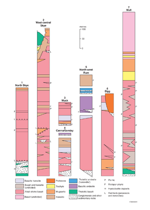


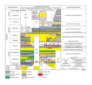



The principal lava sequences are summarised in P914128 and Table 9. Details are given in Tables 11–15. They are:
- Eigg Lava Formation on Eigg, Muck and south-east Rum
- Skye Lava Group on Skye, and including the Canna Lava Formation on Canna, Sanday and north-west Rum
- Mull Lava Group on Mull, Morvern and eastern Ardnamurchan
No lavas occur onshore in the St Kilda archipelago and none are seen on Arran apart from the foundered masses within the Central Arran Ring-complex (p. 137).
Mull Lava Group
The Mull Lava Group crops out throughout north and west Mull, together with the coastal parts of south Mull (around the margin of the younger Mull Central Complex) and the various offshore islands to the west, including Ulva, Gometra, the Treshnish Islands and Staffa. The successions of flat-lying lavas form substantial mountains, such as Ben More, and commonly develop strong trap featuring (P580465). The lavas on the Morvern peninsula, east of Mull, are considered to belong to the Mull Lava Group, as do the lavas east of Ben Hiant, Ardnamurchan, and probably also the isolated outcrops on the south coast of the Ardnamurchan peninsula. Offshore lavas, which extend beneath the Sea of the Hebrides to the Skerryvore Fault, are most likely part of the Mull Lava Group. These flows are probably contemporaneous with flows of the Eigg Lava Formation, which they join in a northern, submarine extension (Fyfe et al., 1993; P914127; Chapter 5).
There has been no detailed regional mapping of the Mull Lava Field since the time of the original survey (Bailey et al., 1924). This account therefore relies to some extent on the synthesis of Richey (1961), together with observations made during the last thirty-five years (e.g. Kerr, 1995b). The lava stratigraphy has been rationalised here, in keeping with that used for the other lava sequences (Table 15).
The remains of the Mull Lava Field as presently exposed, cover an area of about 840 km2 on Mull and Morvern (Emeleus, 1991). The total preserved thickness of lavas on Mull is estimated to be about 1800 m (including an estimated 900 m of olivine-poor tholeiitic basalt lavas now largely within the Mull Central Complex). On the Morvern peninsula, the sequence is about 460 m thick but the lowest lavas thin towards the north (Bailey et al., 1924) and are overstepped by subsequent flows. A thin, laterally continuous sequence of Upper Cretaceous rocks underlies the lavas of Morvern except in the extreme east and north-east of the lava field, where the flows rest directly on pre-Cretaceous rocks (Triassic sandstones and gneisses of the Moine Supergroup). The marginal portion of the lava field was therefore erupted onto, and possibly terminated against, a land surface with a significant topographical relief. The north-west-trending Assapol Fault, in south-west Mull, defines the present-day south-west margin of the lava field.
The volcanic succession on Mull (Table 15) is divided into the Staffa Lava Formation at the base, overlain by the Mull Plateau Lava Formation that consists of the Ben More Main Member and the overlying Ben More Pale Member; these were formerly named, respectively as the Staffa, Main and Pale ‘suites’, of the Plateau Group (e.g. Bailey et al., 1924; Richey, 1961). The Mull Central Lava Formation crops out principally within the Mull Central Complex, and consists of olivine-poor tholeiitic basalt lavas.
The sequence built up by the effusion of lavas, predominantly from north-west-trending fissures now represented by the Mull Dyke Swarm. Pauses in the volcanic activity were more common during eruption of the lower part of the succession. They are marked by the development of laterally discontinuous sequences of conglomerate, sandstone, siltstone and coal. However, unlike the lava piles elsewhere in the Hebridean Igneous Province, the current subdivisions of the Mull lavas are based on lithological changes in the lavas and do not always depend on the presence of interflow sedimentary sequences.
Zeolite minerals are common throughout the lavas. These have been shown to have a depth-related distribution (Walker 1971; P914130), similar to the zonal distribution found in Icelandic lavas. The highest zone is characterised by laumontite and overlies a mesolite zone. Based on comparisons with Icelandic zones, it is estimated that the lavas in the vicinity of Ben More were originally over 2200m in thickness, of which about 1000m is preserved. A distinct zone characterised by carbonate minerals occurs in the lavas near Tobermory and in north-west Morvern, becoming wider northwards towards Ben Hiant on Ardnamurchan. It has been tentatively suggested that the carbonate may have been deposited by circulating heated waters from the Ardnamurchan Central Complex (Walker, 1971). The Mull Central Complex is surrounded by a zone of pneumatolysis, which is superimposed on the depth-related zeolite zones (P914131).
Staffa Lava Formation
The basal part of the volcanic sequence on Mull and locally on Ardnamurchan is marked by the development of a laterally persistent mudstone, the Gribun Mudstone Member, commonly less than 1 m thick, but thicker at several localities. In Morvern it is known locally as the Beinn Iadain Mudstone Formation (P914124). Near Feorlin Cottage at Carsaig, Mull, the mudstone occurs within cavities that developed on the surface of chalk (of possible Turonian age). On the Croggan peninsula south of Loch Buie, at An Garradh, the member consists of about 6 m of buff-coloured calcareous mudstone (marl) and is thought to represent a more aluminous equivalent. These features, together with certain petrographical characteristics (for example the presence of quartz grains), suggest that the mudstone is the product of extreme lateritic weathering of a basaltic ash, which was deposited prior to the effusion of the overlying lavas. The quartz grains were possibly derived from Cenomanian sandstones and introduced either by alluvial or aeolian processes.
At Malcolm’s Point, on the south coast of the Ross of Mull, sedimentary rocks may represent a useful lithostratigraphical marker at the base of the Staffa Lava Formation and above an older, distinctive group of non-columnar flows. The sedimentary sequence comprises a thin carbonaceous mudstone overlain by an upward-fining fluviatile conglomerate–sandstone sequence containing rounded flints (derived from the Turonian Chalk deposits) and more angular fragments of basalt. The sequence is capped by a thin fissile mudstone. The main part of the Staffa Lava Formation comprises a distinctive sequence of tholeiitic basalt flows (defining the Staffa Magma-type or sub-type of Thompson et al. 1986; see Chapter 10). The flows crop out around the sea cliffs of south-west Mull, for example on the Ross of Mull at Malcolm’s Point and Ardtun, at Burg and The Wilderness on the Ardmeanach peninsula, and on Staffa where they overlie hyaloclastite deposits (P580464). Flows of the Staffa Lava Formation also crop out at Bloody Bay, north of Tobermory. Significantly, the formation does not occur everywhere at the base of the lava pile; for example it is absent at Beinn na h-Iolaire in west Mull and throughout the Morvern peninsula (Kerr, 1995b).
Fluvial systems that developed between the eruptions deposited largely clastic sedimentary sequences that are collectively termed the Ardtun Conglomerate Member. These include laterally discontinuous conglomerate–sandstone sequences such as those at Ardtun on the north coast of the Ross of Mull, and laterally equivalent, overbank or lacustrine facies that give rise to siltstone–mudstone–coal–limestone sequences, well preserved on the south coast of the Ross of Mull (Boulter and Kvacek, 1989). The most distinctive field characteristic of flows of the Staffa Lava Formation is the development of typically near-vertical columnar jointing, as exemplified by the Fingal’s Cave Flow on Staffa (P580464). The locally restricted nature of most flows, with columnar joints that in some instances are near-horizontal, is suggestive of cooling against steep-sided walls of palaeovalleys that cut through a dissected plateau. On the Ardmeanach peninsula, a pillowed facies indicates that the MacCulloch’s Tree flow erupted into shallow water. The flow is underlain by interbedded hyaloclastite breccias, together with dark mudstones and siltstones that contain fragments of carbonaceous material (wood), in a fine-grained matrix. The preservation of a cast of an upright tree, ‘MacCulloch’s Tree’ (P580468) is the most remarkable feature of the flow, with columnar jointing becoming severely contorted as it approaches the vertical surface of the trunk.
Mull Plateau Lava Formation
The most complete and relatively simplest succession occurs at Ben More, where both the Ben More Main Member and the Ben More Pale Member are present (Table 15). This succession has been the subject of detailed geochemical examination (Kerr, 1995a; Chambers and Fitton, 2000; Chapter 10).
The Ben More Main Member occurs throughout west Mull, as well as on the Morvern peninsula. Reddened, weathered tops to flows, attributable to subaerial weathering, are relatively common, although interflow clastic sedimentary sequences have not been noted to any significant extent. Certain of the reddened deposits on top of flows have been identified as ashy deposits, probably reworked by stream action (Emeleus et al., 1996a). The member is composed of randomly interleaved flows of olivine basalt and hawaiite, together with rarer picrobasalts, mugearites, benmoreites and trachytes. Certain flows, especially the hawaiites and mugearites, are plagioclase macroporphyritic (the Big Feldspar Basalts of Bailey et al., 1924).
Little detailed information is available about the structure and stratigraphy of the Ben More Main Member. Below, two localities are briefly described, in order to indicate some of the complexities and subtleties that are recognised.
The sequence of flows that forms the coastal cliffs at Laggan Bay, near Ulva Ferry, banked up against, and eventually overstepped, a thick heterogeneous accumulation of basaltic ashes, volcaniclastic breccias and debris flow deposits. These most likely mark the site of a vent that penetrated the lava pile relatively early in the development of the Ben More Main Member. The majority of the clasts within the breccia are of basalt and hawaiite; however, rare but conspicuous angular fragments of Moine psammite and Turonian flint can be identified, indicating that material from the subjacent crust has been transported upwards by the magmas or eroded from surface outcrops.
On the west side of the Quinish peninsula, in north Mull, a remarkably well-preserved lava flow crops out for a distance of at least 800 m along the coast between the high and low water lines. The flow preserves both casts (in basalt) and moulds of tree trunks and possibly branches, most of which are flat-lying, and the majority of which trend north-east–south-west. The upper portion of the underlying lava is severely lateritised, representing the soil in which the trees grew. The flow is remarkably well preserved, with surface features and internal structures more typically seen in active volcanic areas, for example, ropy pahoehoe structures, shell-like pahoehoe crusts, and basal or marginal breccias. The remarkable state of preservation of the flow and the presence of fossil trees are taken as clear indication that the Quinish lava was erupted after a significant hiatus in the volcanic activity, and was itself rapidly buried by the succeeding flow.
The Ben More Pale Member crops out around the summit of Ben More, close to the western margin of the Mull Central Complex and, consequently, has been subjected to intense hydrothermal alteration and metasomatism. It overlies the Ben More Main Member, although no sharp boundary has been identified; rather, there is an interdigitation between the two members, over an interval of a few flows, with the increasing preponderance of pale-weathering flows, up sequence. The pale weathering flows are generally of relatively evolved composition, typified by benmoreites (type locality, first identified by Tilley and Muir, 1964). The lower part of the Ben More Pale Member consists predominantly of mugearite, benmoreite and trachyte. The lavas showing the most evolved compositions are typified in the field by a platy jointing and general fissility, and occur in the middle part of the member. The uppermost part of the member marks a return to significantly less-evolved olivine basalt flows (Kerr, 1995a). Intercalated with the lavas are thin sedimentary deposits; on the north side of Ben More, a benmoreite flow is underlain by 30 to 60 cm of fissile black mudstone containing abundant fragments of benmoreite; a similar deposit at the same stratigraphical level occurs on the east side of A’ Chioch. South of the summit of Ben More, Bailey et al. (1924) recorded about 3 m of brecciated black mudstone with plant remains overlying a mugearite flow.
Mull Central Lava Formation
The Mull Central Lava Formation consists of tholeiitic basalt flows that crop out in small areas within the Mull Central Complex and possibly around its margins, where they overlie the Mull Plateau Lava Formation. The formation is about 900 m thick, and many of the lavas may have been erupted within a water-filled caldera, forming a thick succession of pillowed flows. This is the South-east Caldera or Early Caldera of Bailey et al. (1924); the structure is about 10 km in diameter, and is thought to have developed as a consequence of the summit collapse of a central vent volcano on a site now occupied by the Mull Central Complex. Subsequent intrusive activity within the central complex has dismembered the intrusions. Another caldera was also recognised, the so-called North-west Caldera (Bailey et al., 1924, plate III), but flows of the Mull Central Lava Formation within this structure are not pillowed. Throughout the formation, intense hydrothermal alteration has led to severe changes to the primary mineralogy of many of the lavas, with the development of abundant secondary epidote and prehnite, commonly replacing primary minerals, but also in fracture-filling vein systems.
Within the South-east Caldera, Bailey et al. (1924) recognised three zones within the formation (Table 15), but complications due to subsequent structural and intrusive events prevent the thicknesses of these zones being defined. Pillowed flows are restricted to the Outer Zone and Middle Zone. On the basis of the significant thicknesses of pillow lavas still preserved, Bailey et al. (1924) argued that there must have been successive subsidence of the caldera floor.
It is important to note that the lavas of distinctive tholeiitic basalt composition were not always contained by the caldera wall. It is envisaged that some were able to flow outwards, presumably down the flanks of the volcanic superstructure, and possibly to interdigitate with flows of the Mull Plateau Lava Formation that had been erupted from fissure systems.
Sgurr of Eigg Pitchstone Formation
This formation crops out in south-west Eigg and forms the islets of Oigh-sgeir about 15 km west of Rum (Emeleus, 1997). On Eigg, the formation forms the bare, steep-sided ridge that runs north-west from An Sgùrr to Bidean Boideach. The pitchstone lava is up to 120 m thick, of rhyodacitic composition, and is underlain by pockets of fluviatile conglomerate containing plant remains, which locally reach a thickness of 50 m at Bidean Boideach (P914132). There, and near the eastern end of An Sgùrr (P580469), the steep-sided contacts demonstrate that the pitch-stone and the conglomerates occupied a canyon-like, palaeovalley system eroded in the underlying basaltic lavas of the Eigg Lava Formation (Bailey, 1914). The pitchstone is generally characterised by excellent columnar jointing (P580457). On Eigg, the attitude of the jointing is extremely variable, due to cooling inwards from the steep-sided valley walls and its development has possibly also been influenced by surface water percolating down into the solidifying mass. The fresh rock is a black, glassy pitchstone studded with small feldspar crystals; flow banding may be developed. Devitrification is common, especially near the base where fragmented, altered pitchstone is mixed with underlying sedimentary material, suggesting that phreatic explosions occurred when the pitchstone flowed over wet sediments in a river bed. At Bidean Boideach, western Eigg, a 3 m-thick zone of welded tuff forms the base of the pitch-stone indicating that the initial eruption was an ash flow (P914132). Pale, cream-coloured sheets of devitrified pitchstone, a few metres in thickness, are prominent in the cliffs on the south side of the ridge of An Sgùrr. They represent intrusions of more differentiated rhyolitic magma into the main pitchstone mass.