Oldmill Quarry - locality, Cainozoic of north-east Scotland
| Merritt, J W, Auton, C A, Connell, E R, Hall, A M, and Peacock, J D. 2003. Cainozoic geology and landscape evolution of north-east Scotland. Memoir of the British Geological Survey, sheets 66E, 67, 76E, 77, 86E, 87W, 87E, 95, 96W, 96E and 97 (Scotland).
Contributors: J F Aitken, D F Ball, D Gould, J D Hansom, R Holmes, R M W Musson and M A Paul. |
Oldmill Quarry

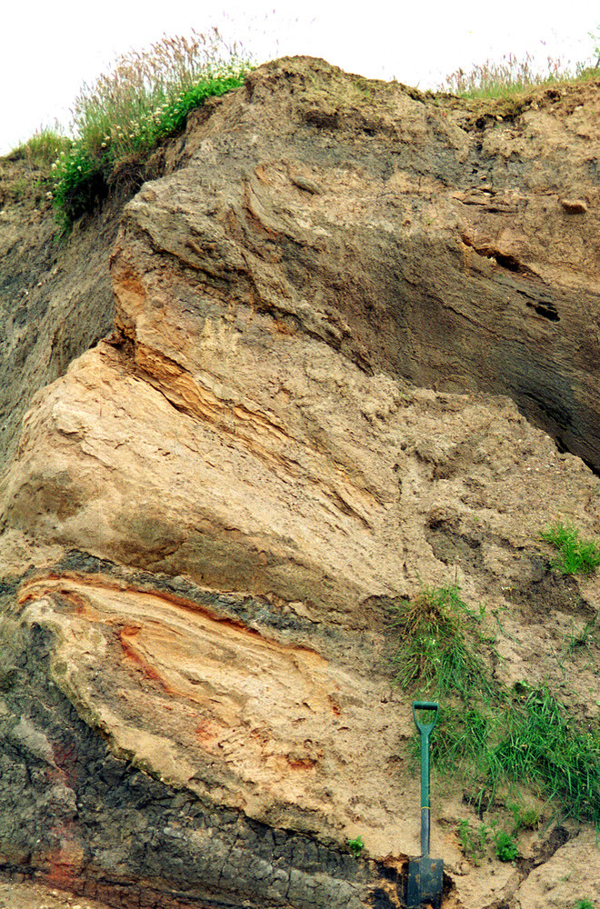
This disused gravel pit (NK 024 439) on Sheet 87(E) Peterhead (P915377) is excavated into the western flank of the Hill of Ludquharn, a triangular-shaped, till-covered, rock-cored hill that appears to have been partially streamlined by ice moving towards the south-east. Deltaic sands and gravels at least 10.4 m thick (McMillan and Aitken, 1981) are overlain by over 6 m of till. The deltaic deposit consists of coarse-grained quartzofeldspathic sand with beds and lenses of cobble gravel composed mainly of pink granite with some weathered grey granite and gabbro. Foresets exposed in the eastern face of the pit indicate deposition by meltwater flowing southwards into a lake ponded up within the valley of the Burn of Ludquharn.

In 1984, the sand and gravel unit was overlain unconformably by about 1.6 m of brown till containing conspicuous basic igneous clasts and other igneous and metamorphic rock-types of western provenance and possessing a weak west to east fabric (Hall, 1984a). The till incorporated at its base several large (many metres across) erratic masses of Jurassic shale and glaciomarine mud probably derived from the Moray Firth (P104119). In 1998, the pit had been extended eastwards into the hill where the till was thicker and now comprised two units separated by a gradational contact (P104106). Other photographs are given in Merritt and Connell (2000).
The lower unit, up to 5 m thick, is a dark grey to dark bluish grey, very stiff, massive, matrix-supported, muddy (silty clay to clayey silt) diamicton with moderately dispersed angular to well-rounded clasts up to 40 cm across. These consist of red sandstone, red granite, basic igneous rocks, psammite, slaty semipelite, well-rounded liver-stained quartzite (from ORS conglomerate) and sparse flint and white sandstone. Several discontinuities and laminae of iron-stained sand occur towards the base of the lower till unit, lying parallel to its sharp, planar to gently undulating, unconformable contact with the underlying sand and gravel. The sand laminae locally pass laterally into lenses up to 1 m thick.
The number of sand lenses within the lower till unit increases towards the south-eastern face of the pit, where they show evidence of complex shearing and interfolding with the bluish grey mud and pebbly mud diamicton. Some of the sand bodies reach 2 m in thickness. The orientation of many overfolds, sheath folds and reversed faults indicate that ice flowed towards the east-south-east. The shearing and attenuation of bedding that has occurred towards the base of the unit is typical of subglacially formed ‘glacitectonites’, similar to those described at the Boyne Limestone Quarry (Site 2) and Gardenstown (Site 3).
The upper till unit is mottled yellowish brown and grey, up to about 2 m thick, and is cut by closely spaced vertical fissures. It is similar in composition and structure to the lower unit. The boundary between the units seen in 1998 is a gradational colour change that occurs over a vertical thickness of 10 cm.
Discussion and correlations
The dark grey clayey till with lenses (rafts) of sand, glaciomarine mud and Jurassic shale is typical of diamictons of the Whitehills Glacigenic Formation that were emplaced by ice flowing towards the south-east from the Moray Firth. The rafts, in particular, are diagnostic of this unit at the type section of the Whitehills Glacigenic Formation at the Boyne Limestone Quarry (Site 2). Here, as at Boyne, they are most common towards the base of the unit and become increasingly sheared and attenuated upwards, merging into homogeneous pebbly diamicton (deformation till). Both units of till at Oldmill contain a suite of rock types that generally match with outcrops lying to the north-west of the site, supporting the east-south-east direction of emplacement deduced from the orientation of some glacitectonic structures in the rafts. However, the significant number of clasts of red granite in the till poses a problem, because although the Forest of Deer Granite is likely to underlie the site (British Geological Survey, 1992), it is grey and the only known outcrops of red granite occur 5 km to the east of the site. The simplest explanation is that they have been derived from the unit of gravel underlying the till, which contains much red granite (see below).
Most researchers would agree that the upper till unit seen in 1998 represents the weathered top of the lower till. However, it is not clear whether the brown till with the weak west–east fabric, basic igneous clasts and western erratic provenance originally recorded by Hall (1984a) is contiguous with this unit of weathered till. It could represent a separate unit (and glacial event) and Connell and Hall (1987) correlated it with the Kirkhill Upper Till (now Hythie Till Formation). If the brown diamicton is simply the weathered top of the grey till, it indicates that during the time taken to deposit the till sequence at Oldmill, the direction of ice movement swung from south-east to east. This is consistent with evidence from the Whitehills Glacigenic Formation at the Boyne Limestone Quarry and Gardenstown, indicating that East Grampian ice gradually became dominant over ice that had earlier pushed inland from the Moray Firth (Peacock and Merritt, 1997, 2000a). The weathering profile is probably postglacial in origin, like that developed on Late Devensian till in Holderness, east Yorkshire (Madgett and Catt, 1978). It is also like that seen affecting blue-grey tills of the Banffshire Coast Drift Group exposed in pipeline trenches north of Peterhead (Essie Till Formation).
The origin of the basal sand and gravel unit is more puzzling. While clearly formed as a southward prograding glaciofluvial delta, the predominant clasts of red granite in the unit are most likely derived from the Peterhead Granite, some 5 km to the east. As the site lies within a valley draining towards the north-east, the ponding is most likely to have been caused by ice encroaching from the north or ponding of the Ugie valley system to the east. The simplest explanation is that the lake was formed by the ice that later overrode the site and deposited the two units of till. If so, ice must also have occupied the coast to the east, blocking drainage in that direction and causing meltwaters to be routed towards the site carrying the clasts of red granite. A similar situation seems to have occurred in the vicinity of the Kirkhill site, 8.5 km to the north-north-west of Oldmill, where the felsitic Denend Gravel Formation was also deposited by westerly directed meltwaters. Those gravels, however, are considered to be considerably older (see Site 7 Kirkhill and Leys).
The solution to this problem of correlation could be that the sand and gravel at Oldmill is much older than the till units overlying it. For example, Connell and Hall (1987) cited evidence (since corroborated by them verbally) from Smith et al. (1977) that ice-wedge casts in the sand and gravel are truncated by an overlying till of western provenance. Furthermore, the ice wedges are associated locally with a thin gelifluctate unit and many of the granite cobbles and boulders are bleached implying that a hiatus of unknown duration occurred between the deposition of the sand and gravel sequence and the tills.