Sand and gravel resources, Sheet 76E Inverurie, Cainozoic of north-east Scotland
| Merritt, J W, Auton, C A, Connell, E R, Hall, A M, and Peacock, J D. 2003. Cainozoic geology and landscape evolution of north-east Scotland. Memoir of the British Geological Survey, sheets 66E, 67, 76E, 77, 86E, 87W, 87E, 95, 96W, 96E and 97 (Scotland).
Contributors: J F Aitken, D F Ball, D Gould, J D Hansom, R Holmes, R M W Musson and M A Paul. |
Sheet 76E Inverurie

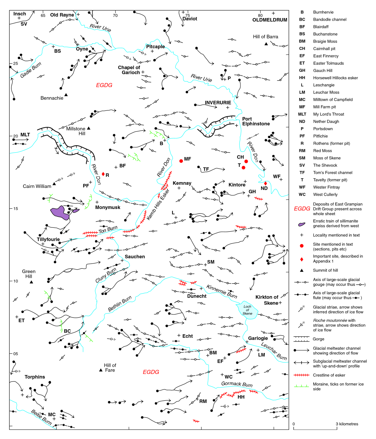
The most extensive spreads of sand and gravel on Sheet 76E (P915378) occur within the valley of the River Don, between Kintore and Inverurie, and between Kemnay and Monymusk. Scattered moundy and terraced spreads of glaciofluvial sand and gravel occur also on the sides of tributary valleys such as the Kinnernie Burn (around Dunecht), and the Leuchar and Gormack burns farther south. Minor resources are also present in the valley of the River Urie (upstream of Inverurie), the valley of the Ton Burn and those of its tributaries (around Sauchen) and the Beltie Burn (around Torphins). The principal resources within the valley of the River Don were evaluated in Mineral Assessment Report 146 and those around Inverurie and Dunecht were evaluated as part of MAR 148. Resources within the remainder of the sheet are described briefly in Gould (1997).
The most attractive resources between Kintore and Monymusk occur within moundy and terraced spreads of glaciofluvial sand and gravel on the southern side of the Don floodplain. These merge with sands and gravels laid down at both ends of a major east–west-trending glacial meltwater channel (the Tom’s Forest Channel) which dissects the interfluve between Kintore and Kemnay. Much of the resource lies above the water table. The deposits vary in composition, from well-bedded sand and fine gravel, to clast-supported boulder gravel and silty sand. Well-bedded sand and gravel was formerly worked in a pit at Tavelty (NJ 780 173), north-west of Kintore. Similar deposits forming a kame-terrace, between Kintore and Inverurie, have been worked extensively also, but much of the remaining resource is sterilised by urban development. Moundy glaciofluvial deposits to the north of Kemnay have been worked in pits near Mill Farm (NJ 736 178), but significant resources remain to the south-east of the village.
Boulder gravels, which are not particularly attractive sources of aggregate, are typical of deposits that form esker ridges, such as the discontinuous Kemb Hills Esker. The latter, which extends for about 5 km to the south-west of Kemnay, generally stands about 6 m above the adjacent gravelly glaciofluvial terrace.
A large resource of gravel underlies the floodplain of the River Don, between Kintore and Inverurie, but it lies entirely below the water table. The deposit appears to thin and become more sandy downstream, where it occurs beneath an increasing thickness of alluvial clay and silt. Smaller resources of waterlogged gravel and sandy gravel underlie the Don floodplain between Burnhervie (NJ 732 194) and Port Elphinstone (NJ 777 202), where they abut fragmentary kame-terraces, and are composed of coarse gravel.
Waterlogged deposits of gravel and sand also continue beneath the Don floodplain between Kemnay and Monymusk. The floodplain is flanked by discontinuous river terraces, mainly composed of fine-grained sand and silt, as well as by terraced gravelly glaciofluvial deposits. The latter merge into glaciofluvial sheet deposits at the western end of a large glacial drainage channel. The sheet deposits were exposed in a pit (NJ 693 173) at Rothens, where they comprised clean, clast-supported gravel with subordinate beds of sand and clay-bound gravel. Thin, flat-lying spreads of water-saturated gravel are also present in the floor of the drainage channel, near Red Moss (NJ 705 179); they abut thicker deposits of poorly sorted, matrix-rich gravel that have been worked north-east of Blairdaff (NJ 696 176). The grading of potentially workable sand and gravel from sample points in the Kintore–Kemnay–Monumusk area is illustrated in Mineral Assessment Report 146 (fig.4).
The spreads of glaciofluvial sand and gravel that flank the valleys of the Kinnernie, Leuchar and Gormack burns, and their tributaries, are generally thinner and less homogeneous than those within the valley of the River Don. Nevertheless, resources of sandy gravel, lying above the water table are widespread in these smaller valleys. They occur as moundy deposits in the valley of the Kinnernie Burn, upstream of Dunecht, as mounds, esker ridges and flat-lying spreads in the valley of the Leuchar Burn, downstream of Garlogie (NJ 783 054), and as mounds, up to 10 m high, near Easter Finnercy (NJ 767 042). Minor resources are also present underlying discontinuous river terraces of the River Urie, upstream of Inverurie.
The moundy glacial deposits that are widespread in the valleys of the western part of the sheet are generally too poorly sorted and bouldery to be considered attractive sources of aggregate. However, small resources of cobble gravel are present in the esker ridges associated with the moundy glacial deposits in the valley of the Ton Burn, and 5 m of well-bedded sand and gravel was exposed in a small pit (NJ 673 109) within terraced glaciofluvial deposits in the vicinity of Monyroads. Some of the glaciofluvial deposits around Sauchen and those in the valley of the Beltie Burn also contain notable amounts of sand and gravel lying above the water table.
Discrete areas of deeply decomposed granitic bedrock, notably on the flanks of Bennachie and around Easter Tolmauds (NJ 626 075), constitute sources of aggregate suitable for use as fill and in the construction of untarred roads.

All of the glaciofluvial deposits on Sheet 76E were laid down by meltwater associated with the decay of ice that moved from west to east across the area and eroded the underlying Dalradian metamorphic and Caledonian igneous bedrock. Consequently, the glaciofluvial gravels are predominantly composed of resistant clasts of metamorphic rock (mainly psammite) and igneous rock (mainly granite). Much of the sand is of granitic composition, being largely derived from local outcrops of deeply weathered granite. The alluvial deposits are of similar character, being largely composed of reworked material from the underlying glacial and glaciofluvial sediments. Numerous clasts of coarse- and fine-grained basic igneous rocks occur in gravels from the Urie catchment (P915335); they are largely derived from the Insch basic igneous intrusion, which crops out in the northern part of the area.
The aggregates appear to be suitable for most end uses, although there are some local variations. The sands and gravel in the catchments of the Kinnernie, Leuchar and Gormack burns, for example, are more sandy and better sorted than deposits in the valley of the River Don, and thus meet a greater range of end-use criteria (for details see Merritt et al., 1988). Sands for use in asphalting are known to be in relatively short supply in the Aberdeen market area, particularly as suitable resources close to the city are largely worked out. The sandy glaciofluvial terraced deposits around Kintore may provide alternative sources of medium- and fine-grained sand.