File list
Jump to navigation
Jump to search
This special page shows all uploaded files.
| Date | Name | Thumbnail | Size | User | Description | Versions |
|---|---|---|---|---|---|---|
| 11:15, 14 February 2024 | P210742.jpg (file) |  |
386 KB | Agarcia | Caption: Shingle storm beach and intertidal sand flat at Snettisham Scalp, Norfolk. Looking north at Snettisham Scalp at the shingle storm beach and intertidal sand flat. On this, the outer face of the storm beach, the gravel is rather coarser and contains a higher proportion of chalk than on the crest of the ridge. Successive high tide marks are indicated by the strand lines of weed. On the left of the picture Wolferton Creek separates the intertidal sand flat from a narrow belt of clay and... | 1 |
| 14:56, 13 February 2024 | GBCoast Approach WPs.png (file) |  |
227 KB | Agarcia | Task 0 changed to WP0 | 2 |
| 09:44, 12 February 2024 | P025917.jpg (file) |  |
232 KB | Agarcia | Parkfield, about 1.25 miles south of Lowestoft. Coast erosion at Pakefield south of Lowestoft. The low cliffs along the coast here are composed of Glacial Sands and Gravels, a loosely-aggregated deposit that offers little resistance to the erosive action of the sea. An exceptionally high tide on November 30th 1936 enabled the waves to attack the cliffs on the north side of Beach Street, causing strips of cliff to fall and abandoned houses to collapse into the sea. | 1 |
| 09:39, 12 February 2024 | P638726.jpg (file) |  |
449 KB | Agarcia | Seaton Cliffs at Mason's Cave in conglomerate and sandstone of the Burnside Sandstone Formation (Stratheden Group) with storm beach ridges in coarse gravel. | 1 |
| 09:33, 12 February 2024 | P005042.jpg (file) |  |
284 KB | Dbk | 1 | |
| 15:07, 30 August 2023 | BGS newlogo.png (file) |  |
74 KB | Dbk | 1 | |
| 15:04, 30 August 2023 | BGS-Logo-Pos-RGB-01.png (file) | 74 KB | Dbk | 1 | ||
| 14:41, 25 July 2023 | CliffMetrics.png (file) |  |
46 KB | Agarcia | Lower resolution image. | 2 |
| 11:20, 25 July 2023 | ODSAS.JPG (file) |  |
61 KB | Agarcia | Open Digital Shoreline Analysis System: ODSAS v1.0 Source J. Mar. Sci. Eng. 2022, 10(1), 26; https://doi.org/10.3390/jmse10010026 | 1 |
| 10:26, 25 July 2023 | Saga-logo.png (file) | 58 KB | Agarcia | SAGA is a Free Open Source Software (FOSS), which generally means that you have the freedom to run the program, for any purpose, to study how the program works and to modify it, to redistribute copies, to improve the program, and release the improvements to the public. Except for the SAGA Application Programming Interface (API) most SAGA source codes have been licenced under the GNU General Public Licence or GPL. The GPL requires derived works to be available under the same or a comparable... | 1 | |
| 13:22, 20 July 2023 | Lolworthcoveweb8a07.png (file) |  |
151 KB | Agarcia | 1 | |
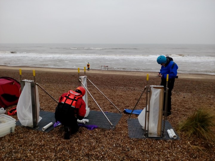
| 12:27, 20 July 2023 | Picture1 150ppi.jpg (file) |  |
99 KB | Agarcia | Team members setting up the [https://doi.org/10.1016/j.coastaleng.2019.103580 portable streamer trap devices] used to measure sediment transport on mixed sand and gravel beaches at Minsmere, eastern England, UK – BGS © UKRI | 1 |
| 11:34, 19 July 2023 | P915396.jpg (file) |  |
589 KB | Scotfot | Table 10 Mineralogical and petrographical characteristics of the principal lava types of the Hebridean Igneous Province. From: The Palaeogene volcanic districts of Scotland] British regional geology Fourth Edition by C H Emeleus B R Bell Contributor: D Stephenson. | 1 |
| 13:19, 28 June 2023 | P1021975.jpg (file) |  |
159 KB | Scotfot | Pharos - ship used by the British Geological Survey during offshore operations. | 1 |
| 13:15, 28 June 2023 | P857178.jpg (file) |  |
142 KB | Scotfot | Justo Sierra - ship used by British Geological Survey during offshore operations. | 1 |
| 13:05, 28 June 2023 | P1027738.JPG (file) |  |
296 KB | Scotfot | Bavenit - ship used by the British Geological Survey for offshore exploration. Photographer: Graham Tulloch. | 1 |
| 11:16, 28 June 2023 | P682037.jpg (file) |  |
289 KB | Scotfot | Cape Shore - ship used in British Geological Survey offshore exploration. Photograph by Graham K. Lott. | 1 |
| 18:49, 21 June 2023 | P506758.jpg (file) |  |
137 KB | Scotfot | RV Kommandor Subsea ship sailing into Scrabster, Thurso, Caithness. Photographer: G.J. Tulloch. | 1 |
| 18:37, 21 June 2023 | P741111.jpg (file) |  |
169 KB | Scotfot | BGS boat 'White Ribbon' during trials on the River Forth in June 2010. Photographer: F. McTaggart. | 1 |
| 18:30, 21 June 2023 | P261452.jpg (file) |  |
169 KB | Scotfot | MV Sperus. Ship used for BGS offshore operations. | 1 |
| 18:12, 21 June 2023 | P507234.jpg (file) |  |
242 KB | Scotfot | RRS Charles Darwin. A ship used for BGS offshore operations. In dock at Barry, Glamorgan. Photographer: G. Tulloch. | 1 |
| 18:02, 21 June 2023 | P261432.jpg (file) |  |
220 KB | Scotfot | MV Whitethorn. A ship used by BGS for 37 cruises. | 1 |
| 14:39, 21 June 2023 | P511534.jpg (file) |  |
191 KB | Scotfot | RRS James Clark Ross tied up at Rothera Research Station jetty, from Memorial Hill, Adelaide Island, west Antarctic Peninsula. 2002. Photographer: G.J. Tulloch. | 1 |
| 14:45, 6 June 2023 | P008737.jpg (file) |  |
226 KB | Scotfot | Group photograph Geological Survey, Edinburgh Office, 1950s. | 1 |
| 14:42, 6 June 2023 | P225814.jpg (file) |  |
469 KB | Scotfot | James McCall, Senior Experimental Officer, Goelogical Survey, Edinburgh Office 1909–1962. | 1 |
| 14:39, 6 June 2023 | P511018.jpg (file) |  |
807 KB | Scotfot | James McCall, Senior Experimental Officer, Goelogical Survey, Edinburgh Office 1909–1962. | 1 |
| 17:26, 13 March 2023 | BGS Hendriks3.jpg (file) |  |
10 KB | Jenbenmather | From GA album: M S Johnstone vol 1 p23 | 1 |
| 12:30, 9 March 2023 | FreedomAndEqualityWomenInGeology.pdf (file) | 137 KB | Scotfot | Freedom and equality: Women in the British Geological Survey by Rod Bowie. | 1 | |
| 13:59, 8 March 2023 | EileenGuppy.pdf (file) | 75 KB | Scotfot | Miss Eileen Guppy c.1904–1980. | 1 | |
| 23:03, 2 February 2023 | BGS FieldSlip.jpg (file) |  |
212 KB | Scotfot | Diagram to show the differences between British Geological Survey 1:10,000/1:10,560 scale field slips and maps. | 1 |
| 10:23, 30 January 2023 | Chroniclesposter.JPG (file) |  |
30 KB | Beod | 1 | |
| 10:02, 30 January 2023 | RwandaWaterPortal.JPG (file) |  |
152 KB | Beod | 1 | |
| 15:17, 26 January 2023 | GWResMan2022.JPG (file) |  |
24 KB | Beod | 1 | |
| 15:17, 26 January 2023 | ProfDrilMan2022.jpg (file) |  |
27 KB | Beod | 1 | |
| 14:55, 26 January 2023 | TrainingCourseProfessionalisingBoreholes.jpg (file) |  |
23 KB | Beod | 1 | |
| 14:52, 26 January 2023 | TrainingCourseProfessionalisingBoreholes.JPG (file) |  |
23 KB | Beod | 1 | |
| 14:25, 23 January 2023 | Iah-logo-2017.png (file) | 15 KB | Beod | 1 | ||
| 14:23, 23 January 2023 | Amcow-logo-md.png (file) | 49 KB | Beod | 1 | ||
| 19:52, 17 December 2022 | P915397.jpg (file) |  |
487 KB | Scotfot | Table 11 The Skye Lava Group: west-central Skye (after Williamson and Bell, 1994). From: Emeleus, C H, and Bell, B R. 2005. British regional geology: The Palaeogene volcanic districts of Scotland. Fourth edition. Keyworth, Nottingham: British Geological Survey. | 1 |
| 13:35, 17 December 2022 | P914157.jpg (file) |  |
383 KB | Scotfot | Uploaded a work by British Geological Survey from British Geological Survey with UploadWizard | 1 |
| 13:35, 17 December 2022 | P914156.jpg (file) |  |
208 KB | Scotfot | Uploaded a work by British Geological Survey from British Geological Survey with UploadWizard | 1 |
| 13:34, 17 December 2022 | P914155.jpg (file) |  |
233 KB | Scotfot | Uploaded a work by British Geological Survey from British Geological Survey with UploadWizard | 1 |
| 13:34, 17 December 2022 | P914154.jpg (file) |  |
252 KB | Scotfot | Uploaded a work by British Geological Survey from British Geological Survey with UploadWizard | 1 |
| 13:34, 17 December 2022 | P914153.jpg (file) |  |
263 KB | Scotfot | Uploaded a work by British Geological Survey from British Geological Survey with UploadWizard | 1 |
| 13:34, 17 December 2022 | P914161.jpg (file) |  |
375 KB | Scotfot | Uploaded a work by British Geological Survey from British Geological Survey with UploadWizard | 1 |
| 13:34, 17 December 2022 | P914152.jpg (file) |  |
189 KB | Scotfot | Uploaded a work by British Geological Survey from British Geological Survey with UploadWizard | 1 |
| 13:34, 17 December 2022 | P914151.jpg (file) |  |
492 KB | Scotfot | Uploaded a work by British Geological Survey from British Geological Survey with UploadWizard | 1 |
| 13:34, 17 December 2022 | P914160.jpg (file) |  |
405 KB | Scotfot | Uploaded a work by British Geological Survey from British Geological Survey with UploadWizard | 1 |
| 13:34, 17 December 2022 | P914159.jpg (file) |  |
406 KB | Scotfot | Uploaded a work by British Geological Survey from British Geological Survey with UploadWizard | 1 |
| 13:34, 17 December 2022 | P914158.jpg (file) |  |
439 KB | Scotfot | Uploaded a work by British Geological Survey from British Geological Survey with UploadWizard | 1 |