The areas around Ord and Tarskavaig, Skye - an excursion
| From: Bell, B.R. and Harris, J.W. An excursion guide to the geology of the Isle of Skye : Geological Society of Glasgow, 1986. © 1986 B.R. Bell & J.W. Harris. All rights reserved. October 2022 note: A new edition of the guide is now available. |


Excursion 2 The areas around Ord and Tarskavaig (Figure 16a), (Figure 16b)
Purpose: To examine rocks of the Tarskaviag and Kishorn Thrust Sheets and the foreland sequence.
Aspects covered: Cambro-Ordovician strata (Lower or False-bedded Division, Pipe Rock, Fucoid Shale, Salterella Grit, Ghrudaidh Dolostone, Eilean Dubh Dolostone, Sailmhor Dolostone); minor thrust planes; Torridonian sedimentary rocks (Applecross Group, Kinloch Formation of the Diabaig Group); the Tarskavaig Thrust Plane; mylonitised Lewisian Gneiss; mylonitised Moine Schists; ordinary (Tarskavaig) Moine Schists.
Route: (Broadford–Ord turn-off–Ord)
- Ord–Cnoc na Fuarachad–Rubha Dubh Ard–(Ord)
- Ord Bay
- Sithean Mor
Distance:
- 5 kilometres
- 1 kilometre
- 2 kilometres
Time:
- 4–5 hours
- 1 hour
- 2 hours
General comments: Parts (i) and (ii) involve coastal exposures and, therefore, low tide conditions are necessary. The roads involved are not suitable for coach parties.
This excursion is split into three parts:
- An inland and coastal section north of Ord (Figure 16a)
- The coastal section around Ord (Figure 16a)
- A traverse up Sithean Mor (Figure 16b)
On the Sleat Peninsula three thrust sheets of Pre-Cambrian rock-types occur with a faulted Cambro-Ordovician foreland sedimentary sequence exposed beneath the lowest thrust plane (10B). The main movements of the thrust planes were to the west, during Lower Palaeozoic times. The tectonic units, in descending order, are:
MOINE THRUST SHEET:
Moine Schists (2C)
Lewisian Gneiss (2A)
Moine Thrust Plane
TARSKAVAIG THRUST SHEET:
Moine Schists (2C)
Lewisian Gneiss (2A)
Tarskavaig Thrust Plane
KISHORN THRUST SHEET:
Torridonian sedimentary rocks (2B)
Kishorn Thrust plane
FORELAND SEQUENCE:
Cambro-Ordovician sedimentary rocks (2D)
Torridonian sedimentary rocks (2B)
(i) An inland and coastal section north of Ord (Figure 16a)
From Broadford proceed south along the Broadford-Armadale (A851) road for 16km (10 miles) to the Ord turn-off and thence along the minor road for 7km (4.5 miles) to Ord. Parking for cars and minibuses is available in the vicinity of the bridge over the Ord River. From the bridge proceed on foot ESE back along the road (towards the Ord turn-off) for 1km to a bend in the road marked by a cattle-grid SSE of Cnoc na Fuarachad.
Locality 1 [NG 6236 1306]
From the road walk NW towards the summit of Cnoc na Fuarachad over exposures of False-bedded Quartzite (2D). These strongly-fractured, impure quartzites are steeply-inclined, with a N-S strike. The dominant impurity is sub-millimetre size crystals of microcline feldspar (milky on fresh surfaces). The identification of cross-bedding, with amplitudes of 5–10cm, indicates that the quartzites young to the west, although more than one exposure may need to be examined to verify the conclusion. Continue to the summit of the Cnoc na Fuarachad and thence WSW to the small N-S-trending valley on the west side of the hill. In so doing, the unexposed boundary between the False-bedded Quartzite and the overlying Pipe Rock (2D) is crossed.
Locality 2 [NG 6208 1316]
Within and on either side of this 25m-wide valley the following rock-types are exposed:# On the east side of the valley, south of the small col, are two steeply-inclined upper bedding surfaces of the Pipe Rock. The topographically lower of these two surfaces is typically and distinctly pockmarked, with small, round structures (1–3cm) which represent sections through pipes
- In the floor of the valley, forming a 0.5m-high ridge south of the col, is the Salterella Grit (2D). This arenaceous rock shows a slight amount of careous weathering and contains the trace-fossil Salterella
- The ground between the Salterella Grit and the Pipe Rock on the east side of the valley (a width of approximately 15m) marks the line of inweathered Fucoid Shale (2D). According to Peach and Horne (1907), this thickness of Fucoid Shale is anomalously thin and suggests the presence of a fault
- To the west of the Salterella Grit is a 15m thickness of pink-weathering Pipe Rock, in this case with haematite-coated clasts, another characteristic of this rock. On the basis of the known stratigraphy elsewhere, (Peach and Horne 1907), the boundary between the Salterella Grit and this outcrop of Pipe Rock must also be interpreted as a fault
- At the summit of the small hill west of the valley the Ghrudaidh Dolostone (2D) crops out. These dark rocks show typical careous weathering, with haematite-coated joint surfaces, and attain a thickness of 30m. The boundary between the Pipe Rock and the Ghrudaidh Dolostone must also be tectonic, as the intervening Fucoid Shale and Salterella Grit are not found
- To the west of the Ghrudaidh Dolostone the overlying Eilean Dubh Dolostone crops out. The junction between these two dolostones is marked by a 1m-high ledge a few metres west of the summit. The Eilean Dubh Dolostones are pale grey, both on weathered and fresh surfaces, and contain abundant chert nodules. 100m north of this summit and on the west side of the N-S -trending valley, a 30cm thick, white, lichen-covered bed occurs within the Ghrudaidh Dolostone. This rock is a sandy limestone, consisting of wind-blown (aeolian), rounded grains of quartz.
Proceed north along the valley for 1km to the north side of the bay on the west side of the Rubha Dubh Ard.
Locality 3 [NG 6210 1394]
The recent beach deposits in this bay consist of debris of the calcareous alga Lithothamnion calcareum in the form of fragments of the thallus. The algal colonies which provide this debris grow on shallow, water-covered ground between the bay and the small, sand-covered in part, island of Eilean Gaineamhach an Arda (Anderson and Dunham 1966). Above the beach is a "25-Foot" raised beach (11C). Continue north for 100m along the beach to a point where a steeply-inclined, irregular dolerite dyke can be traced from the back-wall onto the foreshore. A traverse from the back-wall, westwards, encounters the following sequence of rocks:# 10m north of the dyke, in the back-wall, are thinly-bedded, distinctly pink-weathering quartzites of the Pipe Rock. These steeply-inclined bedding surfaces show excellent outweathered examples of the trace-fossil Skolithos. Typical burrow diameters are 1cm, with the length of the burrow usually equal to the thickness of the bed in which it occurs (unless the bed is particularly thick)
- 10m to the west, the quartzite gives way abruptly to the overlying Fucoid Shale. The first 9m of this rock consists of brown-weathered, purple, sandy shales mixed with thin, yellow, calcareous siltstones. Within this zone lenticular bands of ferruginous dolostone occur and one of them, almost 2m thick, can be located 2m above the base of the Fucoid Shale. The next 20m of Fucoid Shale consists of greenish-grey or bluish-purple shales, together with thin, brown, sandy horizons
- The Salterella Grit begins with a 0.5–1m-high ridge where the beach gives way to seaweed-coated rock. This arenaceous rock has a thickness of approximately 6m and gives way, to the west, to a sand-covered area with a width of 8m, which marks the outcrop of a further thickness of the Fucoid Shale. To the north, this outcrop of Fucoid Shale can be seen to pinch out. On the basis of the known stratigraphic sequence (2D), the boundary between the Salterella Grit and the second outcrop of Fucoid Shale must be tectonic. West of the second outcrop of Fucoid Shale, as far as the Low-Water Line, are further exposures of the Salterella Grit. Approximately 35m of grit can be identified, and the boundary between these strata and the second occurrence of Fucoid Shale, to the east, is also tectonic. This anomalously thick sequence of Salterella Grit consists of a series of ridges and troughs running parallel to the coast and most probably comprises thrusted sheets in a complex association.
Proceed to the south side of the bay, crossing a small pebble beach which provides good samples of the Pipe Rock.
Locality 4 [NG 6196 1392]
The first exposure at the High-Water Line consists of Salterella grit, which represents the continuation of the outcrops seen on the north side of the bay. 10m to the SW brecciated, light grey Eilean Dubh Dolostones crop out and the disrupted boundary between the grit and the dolostone is most easily interpreted as a fault. In the back-wall of the beach, west of the house, both the Ghrudaidh Dolostone (dark grey) and the Eilean Dubh Dolostone (light grey) crop out. Continue SW along the beach over exposures of the Eilean Dubh Dolostone. The following features should be noted within these steeply-inclined strata:# White, black and grey masses of chert, in the form of layers, lenses and nodules
- Wavy laminations and thin bedding units
- Narrow, anastomosing fractures, often haematite-coated, and which are typically outweathered
- Occasional faults which distort the usually steeply-inclined strata. This occurs, for example, at the promontory 200m NE of the cliff-top chalets, where the steeply-inclined strata to the NE abut against flat-lying strata to the SW. These flat-lying dolostones also contain low-angle thrusts which are discordant to bedding
- Tectonic carbonate breccias, for example, immediately NE of the cliff-top chalets, where the bedding returns to a near-vertical attitude
- Small, but clear, sedimentary structures such as ripples and laminations on wave-cut surfaces
- Outwash channels
- Within the exposures above the High-Water Line, on the beach below the cliff-top chalets, are the bores of marine molluscs. These have been interpreted by Peacock (1985) as evidence for a forme higher-than-present water line. The bores are circular in cross-section (12–15mm) with depths of several centimetres. They do not contain any remains of organisms. Peacock (1985) suggests that the bores were formed during the so-called Flandrian (post-glacial shoreline maximum, approximately 6,700 years ago
Locality 5 [NG 6178 1368]
100m SW of the bay in which the cliff-tor chalets are built, the near-vertical junction between the Eilean Dubh Dolostone and the overlying Sailmhor Dolostone crops out. The following distinctive features should be noted within the Sailmhoi Dolostone:# More obvious careous weathering
- More abundant chert
- Evidence of extensive bioturbation, especially within sandy horizons, giving rise to the term "Leopard Stone" (Peach and Horne 1907). Good examples occur in the crags immediately west of the first cottage encountered on a traverse south from the cliff-top chalets
Just west of a derelict building is a small sea-stack of Sailmhor Dolostone which shows further extensive evidence, above the High-Water Line, for the former presence of the boring molluscs referred to above.
Continue south to the bridge over the Ord River.
(ii) The coastal section around Ord (Figure 16a)
Locality 6 [NG 6160 1318]
Immediately north of the bridge over the Ord River the exposures closest to the road are of Eilean Dubh Dolostone. Cross a small sandy beach to the promontory north of the mouth of the river. These exposures consist of white quartzites. The quartzites show very few features and their lack of pipe-like structures suggests that they are most likely part of the Lower Division (2D). The boundary between the Eilean Dubh Dolostone and the quartzite is tectonic and has been named the Ord Thrust—a minor thrust associated with the Moine group of thrusts (Peach et al. 1910). Proceed via the bridge to the headland immediately south of the bay.
Locality 7 [NG 6156 1308]
On the south side of the bay the 10m-high cliff immediately south of the river is composed of Torridonian arkoses and sandstones of the Applecross Group (2B). They have a distinctive chocolate-red colour, with poorly-developed bedding dipping to the south at a shallow angle. On the wave-cut platform NW of the cliff the Lower Division Quartzite crops out (2D). At this locality, the quartzite consists of pebbly layers, with individual clasts up to 5mm in diameter. These sedimentary characteristics are distinctive of the basal portion of the Lower Division Quartzite (2D). Careful examination of the exposures below the boulders at the High-Water Line shows that the contact between the Torridonian strata and the quartzites is not tectonic, but is an unconformity, with the younger quartzite dipping beneath the arkoses and sandstones. Thus, it may be deduced that the sequence is inverted. Proceed around the headland in a south-westerly direction, passing over a 75cm-thick trachyte dyke (which exhibits a platy fracture) of Lower Tertiary age (9K) immediately NE of a wire fence, and a 1.5m-thick dolerite dyke, also of Lower Tertiary age (9B), immediately SW of the wire fence. SW of this fence, in the back-wall of the beach, a NW-SE trending gully defines a faulted junction between the Torridonian strata and the Cambro-Ordovician quartzites. Further along the beach, to the SW, the quartzites are well exposed and cross-bedding indicates that these strata are inverted. Also present is the closure of a fold, with a flat-lying NE limb and a steeply-dipping SW limb. 50m NE of a small promontory the Torridonian sandstones and arkoses again crop out. This exposure represents one end of a wedge-shaped outcrop which can be traced inland. The SW side of this outcrop is faulted against the quartzite and is marked by a NW-SE -trending gully. In the sea cliff, at the back of the promontory, the quartzite is cut by a thrust which is discordant to bedding. The thrust dips to the NW at a shallow angle. Cross-bedding structures and the presence of graded pebble horizons indicate that the quartzites are inverted. The Torridonian sedimentary rocks are found again on the SW side of a 75m-wide pebble beach, forming an obvious cliff. The NE side of this beach is marked by an inweathered fault (trending NNW-SSE) within the quartzites. 15m SW of this fault the Torridonian rocks are found in two prominent tree-covered exposures and also on the adjacent beach. Quartzites are also exposed on the beach and are predominantly conglomeratic. The junction between the Torridonian and Cambro-Ordovician strata can be located to within 2m and, as before, the younger, inverted quartzites lie unconformably below the Torridonian sedimentary rocks.
Return to the road.
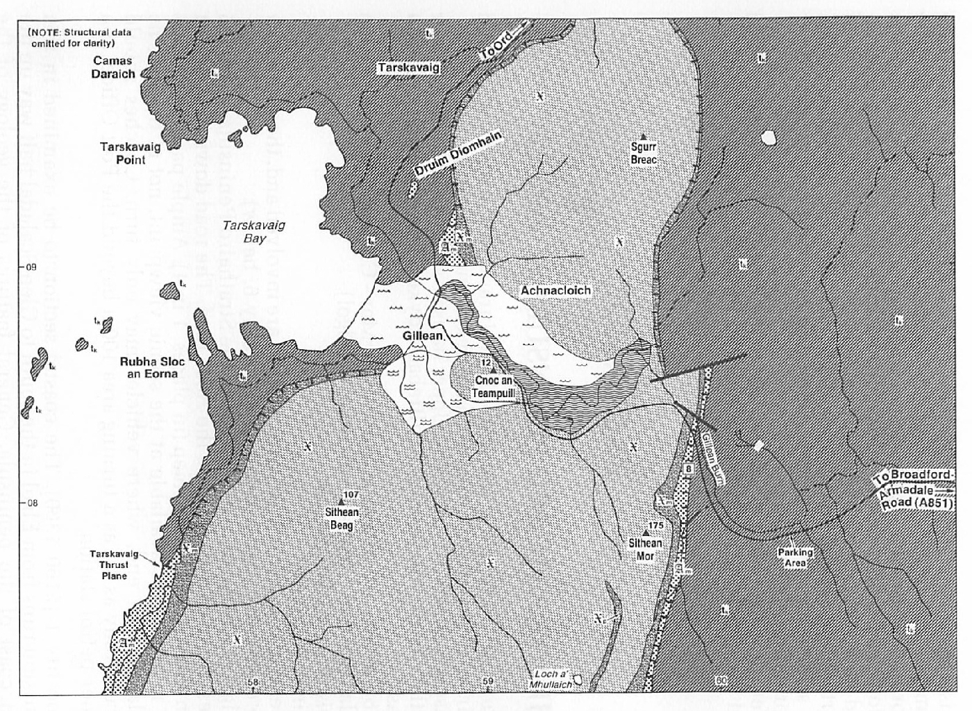
(iii) A traverse up Sithean Mor (Figure 16b)
Proceed south from Ord for 8.5km (5.3 miles) to the east side of Sithean Mor, on the south side of the Gillean burn (3km SE of Tarskavaig). Parking for 3 cars or minibuses is available on the south side of the road within the wooded area. Proceed west on foot to the point on the road-side 200m north of where the trees on the west side of the road give way to heather- and bracken-covered ground. In passing, note within road-cuts, exposures of Torridonian strata of the Kinloch Formation (2B). Proceed up the hill-side on the west side of the road, in a SSW direction, to the first exposures on the hill-side.
Locality 8 [NG 5986 0814]
These rocks are chlorite- and epidote-rich, mylonitised Lewisian gneisses (2A) and form the basal unit of the Tarskavaig Thrust Sheet (10B). These fine-grained, highly-fractured, thinly-foliated rocks are intensely deformed and crop out on a 10m-high, weathered cliff face. Continue uphill, to the WSW, into coarser-grained, less-deformed mylonites. The mylonitic foliation strikes approximately N-S, is steeply inclined, and in places has been folded. The passage upwards, from fine-grained rocks into coarser-grained rocks, indicates a traverse away from the zone of most intense deformation and hence away from the thrust plane. Continue uphill to the plateau area on the north side of the summit of Sithean Mor. Here, mylonitised Moine Schists crop out (2C). Typically, these schists, which belong to the Aruisg Psammite Group (2C), have a greater overall amount of silica than the chlorite- and epidote-rich Lewisian Gneisses. In the plateau region, the mylonitised schists can be distinguished from the underlying mylonitised Lewisian Gneiss by the presence of abundant secondary veins of quartz, often several centimetres thick. Further west, on Sithean Beag, the schists are more typical, containing less vein quartz and fewer deformation structures.
Return to the road and proceed east to the Broadford-Armadale (A851) road (6km (4 miles)) and thence north to Broadford (21km (13 miles)).
References
Appendix 1: Glossary of petrological names and terms
Appendix 2: Glossary of fossil names
Appendix 3: Glossary of place names and grid references
| At all times follow: The Scottish Access Codeand Code of conduct for geological field work |