File list
Jump to navigation
Jump to search
This special page shows all uploaded files.
| Date | Name | Thumbnail | Size | User | Description | Versions |
|---|---|---|---|---|---|---|
| 09:58, 6 June 2014 | P669504.jpg (file) |  |
208 KB | Dbk | 1 | |
| 09:59, 6 June 2014 | P680255.jpg (file) |  |
150 KB | Dbk | 1 | |
| 10:00, 6 June 2014 | P785796.jpg (file) |  |
119 KB | Dbk | Geological timescale. | 1 |
| 10:01, 6 June 2014 | P785802.jpg (file) |  |
79 KB | Dbk | The lithological sequence in an idealised cyclothem. | 1 |
| 10:02, 6 June 2014 | P785806.jpg (file) |  |
107 KB | Dbk | Mesoproterozoic and Neoproterozoic 1600 to 542 million years ago. | 1 |
| 10:03, 6 June 2014 | P785809.jpg (file) |  |
89 KB | Dbk | Mostly Devonian The Old Red Sandstone Supergroup 416 to 359 million years ago. | 1 |
| 10:06, 6 June 2014 | P785812.jpg (file) |  |
78 KB | Dbk | Jurassic and Cretaceous 200 to 65 million years ago. | 1 |
| 10:07, 6 June 2014 | P785816.jpg (file) |  |
141 KB | Dbk | Click on a date/time to view the file as it appeared at that time. | 1 |
| 10:08, 6 June 2014 | P785819.jpg (file) |  |
97 KB | Dbk | Carboniferous palaeogeographical sketch maps. b Early Namurian. | 1 |
| 10:35, 6 June 2014 | P785822.jpg (file) |  |
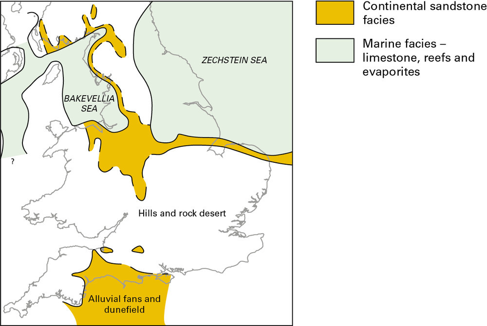
97 KB | Dbk | Late Permian palaeogeographical sketch map. | 1 |
| 10:35, 6 June 2014 | P785825.jpg (file) |  |
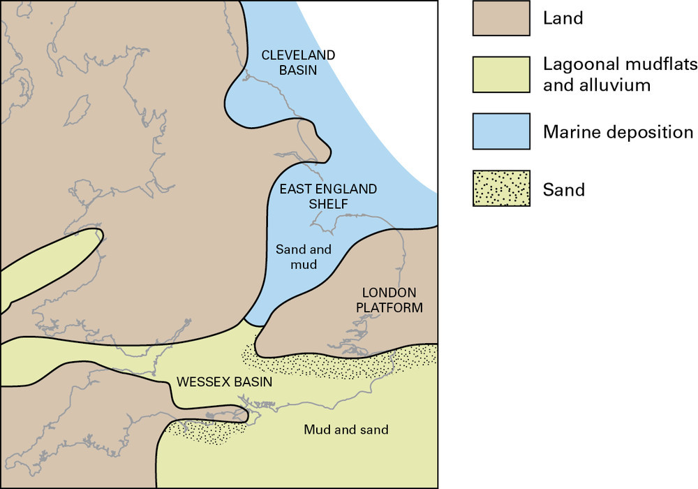
105 KB | Dbk | Early Cretaceous palaeogeographical sketch map. | 1 |
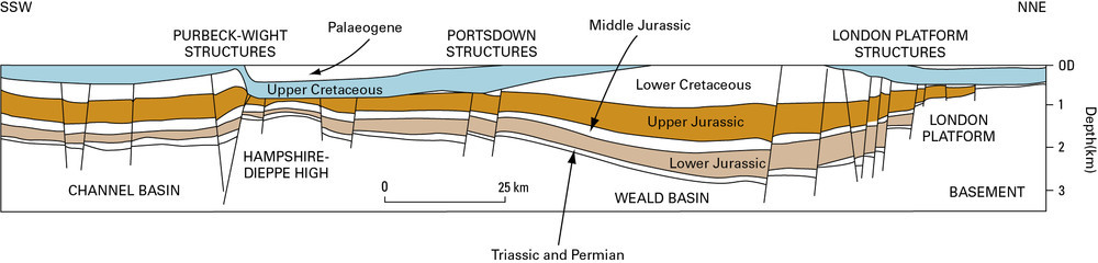
| 10:36, 6 June 2014 | P785829.jpg (file) | 63 KB | Dbk | Schematic cross-section of the Wessex Basin. | 1 | |
| 10:37, 6 June 2014 | P785835.jpg (file) |  |
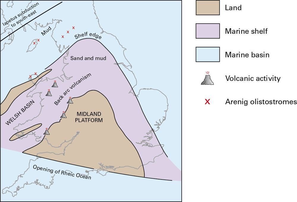
98 KB | Dbk | Palaeogeographical sketch map of England and Wales during early to mid Ordovician. | 1 |
| 10:38, 6 June 2014 | P785838.jpg (file) |  |
44 KB | Dbk | Neoproterozoic 1000 to 542 million years ago. | 1 |
| 10:40, 6 June 2014 | P785841.jpg (file) |  |
43 KB | Dbk | Cambrian 542 to 488 million years ago. | 1 |
| 10:41, 6 June 2014 | P785844.jpg (file) |  |
51 KB | Dbk | Devonian and the Old Red Sandstone 416 to 359 million years ago. | 1 |
| 10:42, 6 June 2014 | P785847.jpg (file) |  |
44 KB | Dbk | Triassic 251 to 200 million years ago. | 1 |
| 11:26, 6 June 2014 | P000613.jpg (file) |  |
209 KB | Dbk | Old Man of Hoy, north-west coast of Hoy. Orkney. A 137 m. sea stack composed of red sandstone of Upper Old Red Sandstone age. The stack rests on a pediment of Upper Old Red Sandstone basalt lava which unconformably sits on flagstones of Middle Old Red ... | 1 |
| 11:27, 6 June 2014 | P000742.jpg (file) |  |
140 KB | Dbk | Obique aerial view looking north-east along the Great Glen from Banavie shows a linear fault-determined glen with glacial basins of Loch Lochy, Loch Oich and Loch Ness and U-shaped glacially scoured valley along the fault line. The Great Glen Fault Zon... | 1 |
| 11:27, 6 June 2014 | P000818.jpg (file) |  |
523 KB | Dbk | Basal breccia or conglomerate of Upper Old Red Sandstone dipping at a low angle to left (north), resting on vertical shaly siltstone and thin greywacke of Silurian (Llandovery) age. The breccia consists of angular fragments of greywacke in a red, sandy... | 1 |
| 11:28, 6 June 2014 | P000965.jpg (file) |  |
162 KB | Dbk | Above the scarp lies a peaty platform composed of Cambrian Pipe Rock with some 'Fucoid' Beds at the eastern edge. Above the platform rises gneiss which has been carried on the combined Sole and Glencoul Thrust Planes and forms the main hill of Aird da ... | 1 |
| 11:29, 6 June 2014 | P001097.jpg (file) |  |
165 KB | Dbk | Bass Rock from Seacliff Harbour, East Lothian. The islet is a volcanic plug composed of a non-porphyritic, orthophyric, fairly coarse-grained phonolitic trachyte, an intrusion related to the Garleton Hills Volcanic Rocks. The rocks in the foreground ar... | 1 |
| 11:30, 6 June 2014 | P001157.jpg (file) |  |
204 KB | Dbk | Looking south-west along the summit ridge of the 'Grey Corries' towards Aonach Beag (1234 m.). Glen Roy district, Lochaber. Well-bedded quartzites of the Glencoe Quartzite (Lochaber Subgroup) are well exposed with extensive areas of scree from frost-sh... | 1 |
| 11:31, 6 June 2014 | P001267.jpg (file) |  |
489 KB | Dbk | Oblique aerial view of Edinburgh Castle Rock and the Arthur's Seat volcano, looking from the west-north-west. In the foreground, Edinburgh Castle sits on dolerite plugging a Lower Carboniferous volcanic vent intruded into softer sedimentary rocks. Glac... | 1 |
| 11:32, 6 June 2014 | P002763.jpg (file) |  |
127 KB | Dbk | Ben Hope looking north-north-east from Alltnacaillich, Sutherland. Coarse feldspathic and siliceous Moine psammites dipping gently to the east intruded by the basic 'Ben Hope Sill'. The sill forms the long escarpment and can be traced for many miles an... | 1 |
| 11:33, 6 June 2014 | P005147.jpg (file) |  |
175 KB | Dbk | Hollin House Tongue, Seathwaite, Duddon Valley, Cumbria. Typical thin parallel-bedded sub-aerial volcaniclastic rocks that show a great variation in size. | 1 |
| 11:33, 6 June 2014 | P005554.jpg (file) |  |
242 KB | Dbk | Combs Quarry, Foredale. Looking W. Sub-Carboniferous unconformity. Steep, southwardly dipping Horton Formation laminated siltstones are overlain by horizontal, well-bedded Dinantian limestones. | 1 |
| 11:34, 6 June 2014 | P005775.jpg (file) |  |
346 KB | Dbk | Stair Hole Cove, West Lulworth. Looking E. Stair Hole. Junction of Lower Purbeck and Portland Stone. | 1 |
| 11:35, 6 June 2014 | P005990.jpg (file) |  |
208 KB | Dbk | Blindwells Opencast Site, Tranent. Limestone Coal Group strata, from Great Seam Coal to Four Foot Coal; shows small fault; variable overburden of glacial till; temporary spoil heap in far left, back-filled spoil near left. | 1 |
| 11:36, 6 June 2014 | P006254.jpg (file) |  |
146 KB | Dbk | Drabber Tor, Wolfscote Dale at confluence with Biggin Dale, Derbyshire/N. Staffs. Looking NW. Castellated crags flanking the southern part of Wolfscote Dale composed of well-bedded pelletal calcarenitic limestone with thin micritic limestones of Lower ... | 1 |
| 11:44, 6 June 2014 | P006782.jpg (file) |  |
295 KB | Dbk | Flamborough Head. Looking WNW. Cliffs in Selwicks Bay. Well-bedded Upper Chalk with flints shows slight disturbance which has probably been caused by ice movement. In the background the cliffs are capped by landslipped Devensian glacial deposits. | 1 |
| 11:45, 6 June 2014 | P007054.jpg (file) |  |
203 KB | Dbk | W. of Cwm Croesor. Acid (granophyre) sill forms main feature with cleaved mudstones on either side mostly hidden by grass. Cnicht summit in distance. | 1 |
| 11:46, 6 June 2014 | P007262.jpg (file) |  |
129 KB | Dbk | 2 km. SE of Llanberis on A 4086. Llyn Peris and the Llanberis Pass. Massive outcrops of folded Bronllwyd Grit on the steep slopes behind the cottage. | 1 |
| 11:47, 6 June 2014 | P007523.jpg (file) |  |
189 KB | Dbk | High Cup Gill. Looking S. Whin Sill pinnacle on north side of High Cup Gill, showing rude columnar jointing. | 1 |
| 11:48, 6 June 2014 | P007923.jpg (file) |  |
401 KB | Dbk | South Stack. Folded schists of the Mona Complex. These Precambrian rocks exhibit corrugation in the softer beds and vertical foliation in the harder ones. | 1 |
| 11:49, 6 June 2014 | P008157.jpg (file) |  |
193 KB | Dbk | Coastal cliff, 1 m. SSW of Upper Borth. Harp Rock'. The base of Aberystwyth Grits is taken here at the bottom of the lowest of the three prominent turbidites. | 1 |
| 11:50, 6 June 2014 | P008228.jpg (file) |  |
287 KB | Dbk | Craig y Benglog. Looking N. Bedded hyalocastite', associated with pillow lavas on Craig y Benglog. Benglog Volcanic Formation. This massive unit has a very limited vertical and lateral extent. The massive lower part consists of lapilli-sized fragments ... | 1 |
| 11:51, 6 June 2014 | P008440.jpg (file) |  |
243 KB | Dbk | Kirkmabreck Quarry, Creetown. Microdiorite dykes in metasandstone above granite (Bench 3) looking north-east. Microdiorite dykes, approximately bed-parallel in the darker metasediment (see D3920-D3921 for details) above the contact (left of, and above ... | 1 |
| 11:52, 6 June 2014 | P018619.jpg (file) |  |
226 KB | Dbk | Douglas Bay, Isle of Man. Very thin (-thin) bedded sandstone and mudstone of Lonan Formation. | 1 |
| 11:53, 6 June 2014 | P064460.jpg (file) |  |
465 KB | Dbk | N. of Carstairs, looking SW. Carstairs Kames, view of sand and gravel ridges, peaty hollows and workings of Eastend Pit. | 1 |
| 11:54, 6 June 2014 | P209677.jpg (file) |  |
213 KB | Dbk | View north-east from Bwlch-y-Clwydd along Cwmparc. A typical small coal mining village, Cwmparc, showing ribbon-development along the valley from its confluence at Treorchy (right middle distance) with the Rhondda Fawr. On the hillslopes lines of old c... | 1 |
| 11:54, 6 June 2014 | P211084.jpg (file) |  |
588 KB | Dbk | Crawley Church is typical of most older parish churches in Britain being constructed almost completely from locally available materials, in this case sandstone from the Upper Tunbridge Wells Sand Formation and clay ironstone from the Weald Clay Formati... | 1 |
| 12:16, 6 June 2014 | P219672.jpg (file) |  |
398 KB | Dbk | Viewpoint from Glen Torridon Road, looking S. into unnamed river valley. Hummocky moraines of probable Loch Lomond Readvance age. Glen Torridon. | 1 |
| 12:17, 6 June 2014 | P220426.jpg (file) |  |
409 KB | Dbk | Brighouse, 3 km. S. of Borgue. Looking NE. S1 cleavage in Carghidown Formation, Hawick Group. | 1 |
| 12:20, 6 June 2014 | P222330.jpg (file) |  |
271 KB | Dbk | Crag Lough and Highfield Crags, Roman Wall. North-facing scarp of the Whin Sill ponding back the lake which probably occupies the site of a once far more extensive glacial lake. Flat ground to the right underlain by peat and alluvium. Note gaps in the ... | 1 |
| 12:21, 6 June 2014 | P223200.jpg (file) |  |
289 KB | Dbk | Castle Folds, a small mesa on Orton Knott with the Eden Valley and Alston Block in the background. Limestone pavement on the Knife Scar Limestone at Castle Folds. Limestone pavement on the Knife Scar Limestone about 40 m. above the base of that formation. | 1 |
| 12:22, 6 June 2014 | P225312.jpg (file) |  |
357 KB | Dbk | Magheramorne Quarry, County Antrim. Looking S. Section at Magheramorne Quarry. Tertiary basalt lavas resting on Chalk (Upper Cretaceous). | 1 |
| 12:23, 6 June 2014 | P506771.jpg (file) |  |
138 KB | Dbk | Durness, Caithness. Entrance to Smoo Cave from cliffs above. | 1 |
| 12:27, 6 June 2014 | P545612.jpg (file) |  |
137 KB | Dbk | View of Salisbury Crags and Edinburgh Castle. Edinburgh Castle Rock, a 345 Million year old volcanic neck viewed from above the Radical Road to the quarried scarp of well jointed, intrusive dolerite sill of Salisbury Crags. | 1 |
| 12:28, 6 June 2014 | P547039.jpg (file) |  |
225 KB | Dbk | Conglomerate and sandstone of the Rova Head Conglomerate Formation. | 1 |