File list
Jump to navigation
Jump to search
This special page shows all uploaded files.
| Date | Name | Thumbnail | Size | User | Description | Versions |
|---|---|---|---|---|---|---|
| 09:57, 6 June 2014 | P667873.jpg (file) |  |
217 KB | Dbk | 1 | |
| 09:56, 6 June 2014 | P667863.jpg (file) |  |
121 KB | Dbk | 1 | |
| 09:56, 6 June 2014 | P667860.jpg (file) |  |
150 KB | Dbk | 1 | |
| 09:54, 6 June 2014 | P667856.jpg (file) |  |
103 KB | Dbk | 1 | |
| 09:53, 6 June 2014 | P649399.jpg (file) |  |
145 KB | Dbk | 1 | |
| 09:52, 6 June 2014 | P616087.jpg (file) |  |
487 KB | Dbk | Typical texture of the Lewisian Gneiss Complex as seen in a quarry on the north side of Vatersay Causeway, Barra, Outer Hebrides. | 1 |
| 09:51, 6 June 2014 | P580468.jpg (file) |  |
267 KB | Dbk | Maculloch's Tree (cast of) encased in columnar basalt. Ardmeanach, Mull. Scale: hammer shaft is 30 cm. | 1 |
| 09:50, 6 June 2014 | P556198.jpg (file) |  |
127 KB | Dbk | View to north from disused sandstone quarries on the slopes of Towns Fell, above Gawthorp in Dentdale. Sandstone of Brigantian age Alston Formation. | 1 |
| 09:49, 6 June 2014 | P548172.jpg (file) |  |
203 KB | Dbk | 1 | |
| 09:48, 6 June 2014 | P547034.jpg (file) |  |
293 KB | Dbk | Dessication polygons in sandstone, Lybster Subgroup, Lower Caithness Flagstone Group. | 1 |
| 17:17, 5 June 2014 | P225483.jpg (file) |  |
264 KB | Dbk | Magheramorne Quarry. Ulster White Limestone. Well-bedded hard white chalk with flint bands and erosion surfaces outlined by orange-brown clay. | 1 |
| 17:16, 5 June 2014 | P225292.jpg (file) |  |
297 KB | Dbk | Knockmore Cliff, County Fermanagh. Looking SW. Knockmore Cliff. Scarp and scree in massive limestone, probably Upper Limestone, Carboniferous Limestone Series. | 1 |
| 17:14, 5 June 2014 | P222619.jpg (file) |  |
213 KB | Dbk | 50 m W. of Grimbald Crag, Knaresborough. Looking SE. The Carboniferous/Permian unconformity at Grimbald Crag, Knaresborough. Oolitic limestones of the Lower Magnesian Limestone - Upper Subdivision rest unconformably upon a buried hill of slightly redde... | 1 |
| 17:14, 5 June 2014 | P221294.jpg (file) |  |
278 KB | Dbk | Blackhall Rocks. Looking N. Eastern tip of headland, showing algal stromatolitic ?Hartlepool and Roker Dolomite with conspicuous bed of coarse rolled stromatolite blocks. | 1 |
| 17:13, 5 June 2014 | P220190.jpg (file) |  |
506 KB | Dbk | Dobb's Linn. Large groove cast on base of greywacke bed. The main waterfall flows down the slightly overturned base of a thick greywacke bed. The large groove casts are seen to the right of the waterfall. | 1 |
| 17:12, 5 June 2014 | P219662.jpg (file) |  |
329 KB | Dbk | N. of Loch Quoich, Kinloch Hourn Road and NE of Loch a' Choire Bheithe. Glenfinnan Group. Folded striped psammite and pelite typical of the Glenfinnan Group. Axial fabrics can be seen in pelite beside the hammer. | 1 |
| 16:42, 5 June 2014 | P895014.jpg (file) |  |
172 KB | Dbk | The development of the terminology in the offshore UK Sector. | 1 |
| 16:41, 5 June 2014 | P895010.jpg (file) |  |
176 KB | Dbk | The Inner Hebrides Scottish Chalk Province. | 1 |
| 16:40, 5 June 2014 | P895007.jpg (file) |  |
155 KB | Dbk | The development of the terminology in Norfolk (Transitional Province). | 1 |
| 16:38, 5 June 2014 | P895004.jpg (file) |  |
179 KB | Dbk | The Chalk group provinces of England. | 1 |
| 16:35, 5 June 2014 | P207609.jpg (file) |  |
357 KB | Dbk | On shore, W. side of Humphrey Head, 3 m. SW of Grange-over-Sands. Looking W. Permian Brockram. To show more detailed lithology. Note the angular fragments, most of which are Carboniferous Limestone converted into dolomite, and the absence of sorting. | 1 |
| 16:34, 5 June 2014 | P064459.jpg (file) |  |
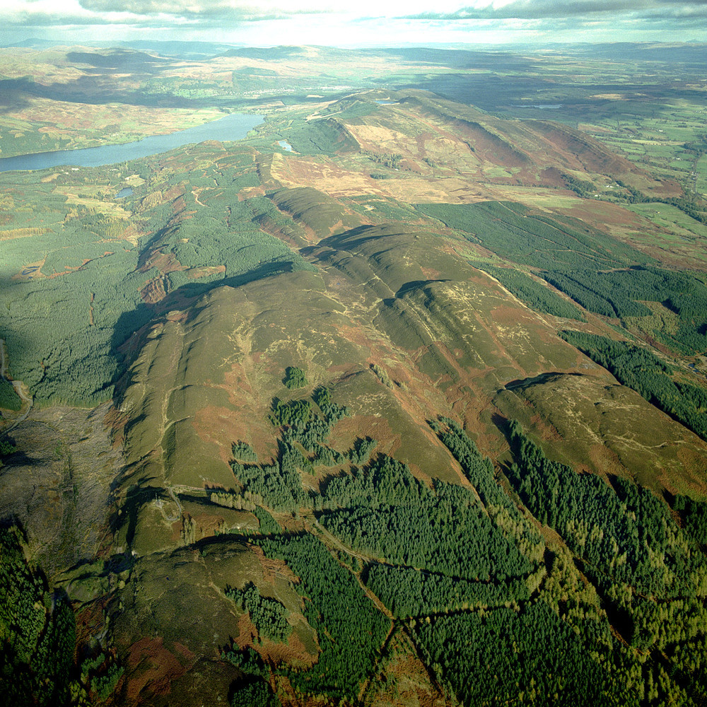
292 KB | Dbk | Gargunnock Hills, north scarp. | 1 |
| 16:33, 5 June 2014 | P008633.jpg (file) |  |
382 KB | Dbk | Auchterteang. Migmatitic psammite/micaceous psammite. F2 minor folds with S2 shears developed on fold limbs with new segregations. | 1 |
| 16:32, 5 June 2014 | P008322.jpg (file) |  |
165 KB | Dbk | Castlebay, Isle of Barra. Lewisian gneiss, Heaval. | 1 |
| 16:31, 5 June 2014 | P008226.jpg (file) |  |
486 KB | Dbk | SW slope of Craig y Benglog. Looking N. Pillow lava in the Benglog Volcanic Formation (Ordovician). | 1 |
| 16:30, 5 June 2014 | P007969.jpg (file) |  |
209 KB | Dbk | Scarp at Cynant Isaf, NNW of Lanfair Talhaiarn. Elwy Group: (scanicus Zone or above). 'Cynant Beds' interbedded sandstones and disturbed beds. | 1 |
| 16:28, 5 June 2014 | P007705.jpg (file) |  |
265 KB | Dbk | Coastal section from Lavernock to Penarth. Looking N. Coastal section from Lavernock to Penarth Head. On the left, Penarth Group black shales overlie Keuper Tea Green Marl and Red Marl with gentle southerly dip. These beds form the southern limb of a s... | 1 |
| 16:27, 5 June 2014 | P007442.jpg (file) |  |
403 KB | Dbk | Llanberis Pass. Bedding in sandstones. Detail of bedding in sandstones below Pitts Head Tuff showing even and cross-bedded laminae and soft sediment deformation. | 1 |
| 15:00, 5 June 2014 | P007261.jpg (file) |  |
252 KB | Dbk | SE of Llyn Padarn, near Pen-gilfach. Llanberis Pass (centre background) with outcrops of welded ash-flow tuff of the Padarn Tuff Formation in the foreground and slate quarries in the Llanberis Slates Formation in the middle distance. | 1 |
| 14:59, 5 June 2014 | P006953.jpg (file) |  |
247 KB | Dbk | Kilve. Looking NE. Cliff in Blue Lias strata. Alternating shales and limestones of the Blue Lias. The lower part of the cliff comprises the higher part of the Schlotheimia angulata Zone, with the succeeding Arietites bucklandi Zone present at the top. ... | 1 |
| 14:58, 5 June 2014 | P006779.jpg (file) |  |
205 KB | Dbk | Newbiggin Cliff near Filey. Looking ESE. The cliff is composed of Oxford Clay overlain by Corallian rocks. Glacial till forms the gentler upper slopes which display gully erosion. | 1 |
| 14:57, 5 June 2014 | P006482.jpg (file) |  |
209 KB | Dbk | Giant's Causeway. Looking E. The top of the Grand Causeway in the foreground, with the cliffs of Roveran Valley Head and Spaniard Rock across Port Noffer. The upper part of the cliffs including the Chimney Tops, is in three flows of tholeiitic basalt. ... | 1 |
| 14:56, 5 June 2014 | P006066.jpg (file) |  |
239 KB | Dbk | Carn Kenidjack, Carnyorth Common. Looking ESE. Granite tor. A rare fine-grained granite tor. | 1 |
| 14:54, 5 June 2014 | P005864.jpg (file) |  |
275 KB | Dbk | Ardwell Bay. Ardwell Flags. Vertical greywackes, siltstones of the Caradocian, Ardwell Group. | 1 |
| 14:52, 5 June 2014 | P005755.jpg (file) |  |
309 KB | Dbk | Cowsen Gill, near Keasden. Thin coal and seatearth in the Roeburndale Formation. The following section is exposed in the north-east bank of Cowsen Gill: sandstone fine-grained, quartzitic, passes upwards into 2.40 m. ganister. Siltstone, sandy, micaceo... | 1 |
| 14:51, 5 June 2014 | P005543.jpg (file) |  |
288 KB | Dbk | Arcow Quarry. Looking W. Folded Austwick Formation, Arcow Formation and unconformity. A major anticline, with an easterly-plunging axis is present in well-bedded, arkosic sandstones with interbedded units of laminated siltstone. The Arcow Formation (at... | 1 |
| 14:49, 5 June 2014 | P002200.jpg (file) |  |
232 KB | Dbk | The boulder beds consist of angular blocks and boulders varying in diameter from a few centimetres to the nearby 'fallen stack' which measures 34 m. x 27 m. x 9 m. and set in a sandy matrix that includes fossils of creatures that originally lived in sh... | 1 |
| 14:47, 5 June 2014 | P001255.jpg (file) |  |
537 KB | Dbk | The sharp break in slope at their north-west (left) margin marks the presence of Highland Border Complex rocks, exposed in Lime Craig Quarry (below the TV repeater station). These are serpentinites, Lower Arenig limestones and early conglomerates. They... | 1 |
| 14:46, 5 June 2014 | P001153.jpg (file) |  |
438 KB | Dbk | Inverlair Gorge, River Spean. Grampian Region. The type section through massive psammites and quartzites with semipelitic layers of the Inverlair Psammite Formation of the Grampian Group. The valley is in its early stages of development. Downcutting by... | 1 |
| 14:43, 5 June 2014 | P001091.jpg (file) |  |
369 KB | Dbk | Back Water (Fairy Castle Dean), Oldhamstocks. East Lothian. Conglomerate (Great Conglomerate, Lower Devonian) showing valley and recent erosion features. The erosional features, earth pillars, are the conical columns produced by differential erosion in... | 1 |
| 14:42, 5 June 2014 | P000885.jpg (file) |  |
367 KB | Dbk | Immediately below the sill is the White Sandstone, and below that is the Inferior Oolite. Above the sill but covered by the landslip is the Great Estuarine Series. The sill shows columnar jointing with the columns near vertical and normal to the beddin... | 1 |
| 14:41, 5 June 2014 | P000816.jpg (file) |  |
321 KB | Dbk | Broadhaven Bay, St. Abb's from the east-north-east. Berwickshire. The rocks are Silurian (Llandovery) greywackes and siltstones folded by repeated broad flexures with an east-north-eastwards trend. A typical fold is seen in the bay, the detail of the s... | 1 |
| 14:38, 5 June 2014 | P000699.jpg (file) |  |
214 KB | Dbk | The upper cliffs of Aonach Dubh (pale) are rhyolite lavas resting on lavas of basic andesite, all of Lower Old Red Sandstone age. An t-Sron (on right) is composed principally of granite forming the Glen Coe Ring Fault Intrusion. The Glen Coe Ring Fault... | 1 |
| 13:45, 5 June 2014 | Warning triangle.png (file) |  |
19 KB | Dbk | 1 | |
| 08:52, 5 June 2014 | P000207.jpg (file) |  |
368 KB | Dbk | View from south-east side of Kemnay Quarry, looking to north-west. Aberdeenshire. Kemnay Quarry with Bennachie in background. Foreground shows Kemnay Quarry working the Kemnay granite. Flooded area marks site of part of the 19th century workings. High ... | 1 |
| 12:56, 3 June 2014 | P785800.jpg (file) |  |
57 KB | Dbk | Moving continents: reconstructions of the positions of the main landmasses and their continental shelves from Neoproterozoic to Cenozoic times. Modern coastlines are included for reference. | 1 |
| 12:55, 3 June 2014 | P785799.jpg (file) | 71 KB | Dbk | Moving continents: reconstructions of the positions of the main landmasses and their continental shelves from Neoproterozoic to Cenozoic times. Modern coastlines are included for reference. | 1 | |
| 15:22, 23 May 2014 | P895150.jpg (file) |  |
105 KB | Dbk | Image of artesian groundwater borehole at CEH Wallingford, Oxfordshire. | 1 |
| 12:17, 23 May 2014 | Down green arrow.png (file) | 32 KB | Dbk | 1 | ||
| 13:39, 22 May 2014 | Down arrow.png (file) | 32 KB | Dbk | 1 |