File list
Jump to navigation
Jump to search
This special page shows all uploaded files.
| Date | Name | Thumbnail | Size | User | Description | Versions |
|---|---|---|---|---|---|---|
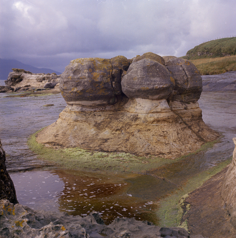
| 11:01, 9 June 2014 | P000654.jpg (file) |  |
353 KB | Dbk | North side of the Bay of Laig, Isle of Eigg. Inverness-shire. Large carbonate concretions in the Valtos Sandstone Formation (Jurassic). The carbonate concretions are believed to have formed during the late Jurassic burial of sand bodies, when calcite p... | 1 |
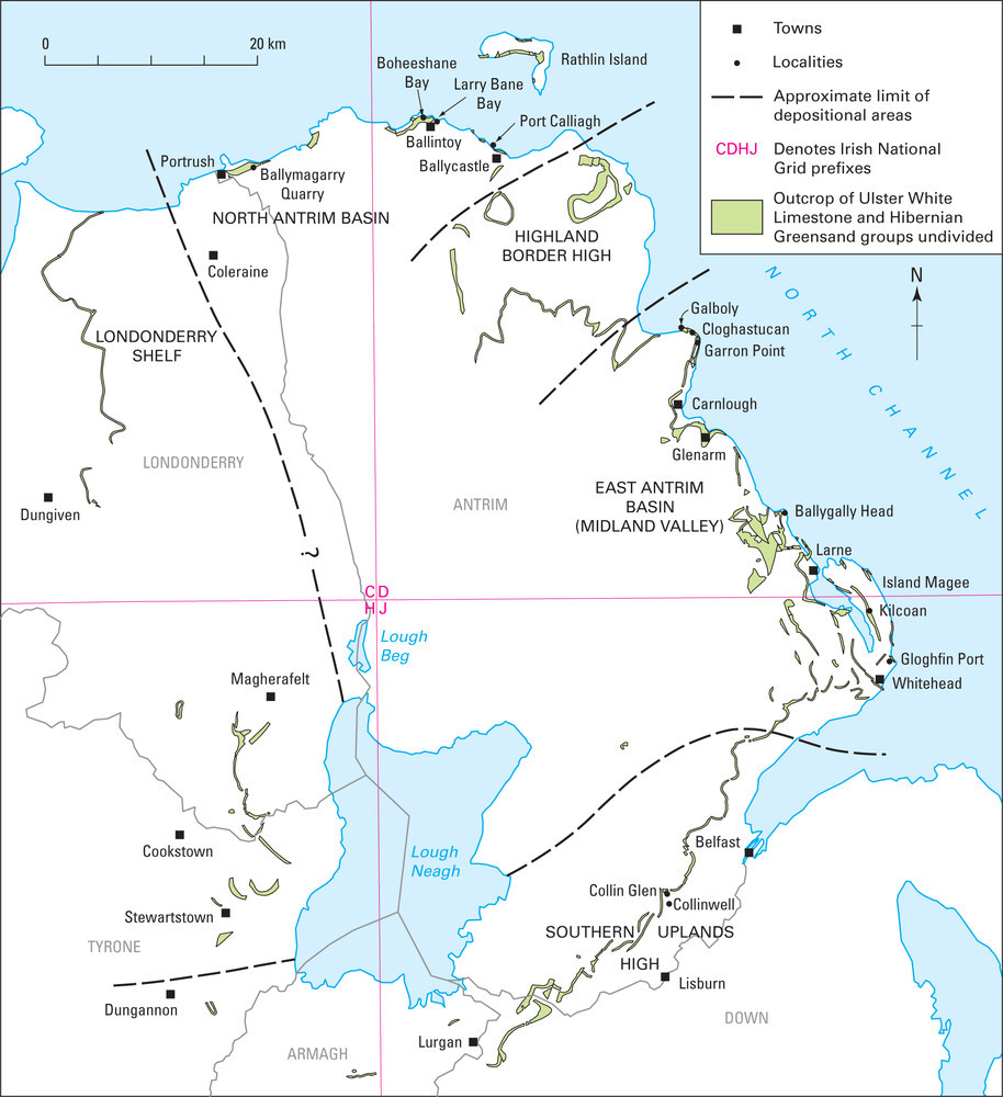
| 10:41, 9 June 2014 | P895013.jpg (file) |  |
193 KB | Dbk | The Northern Ireland Cretaceous Province. | 1 |
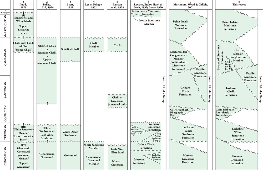
| 10:41, 9 June 2014 | P895009.jpg (file) |  |
147 KB | Dbk | The development of the terminology in the Scottish Chalk Province. | 1 |
| 10:40, 9 June 2014 | P895006.jpg (file) |  |
157 KB | Dbk | The development of the terminology in south-east Devon (Southern Province). | 1 |
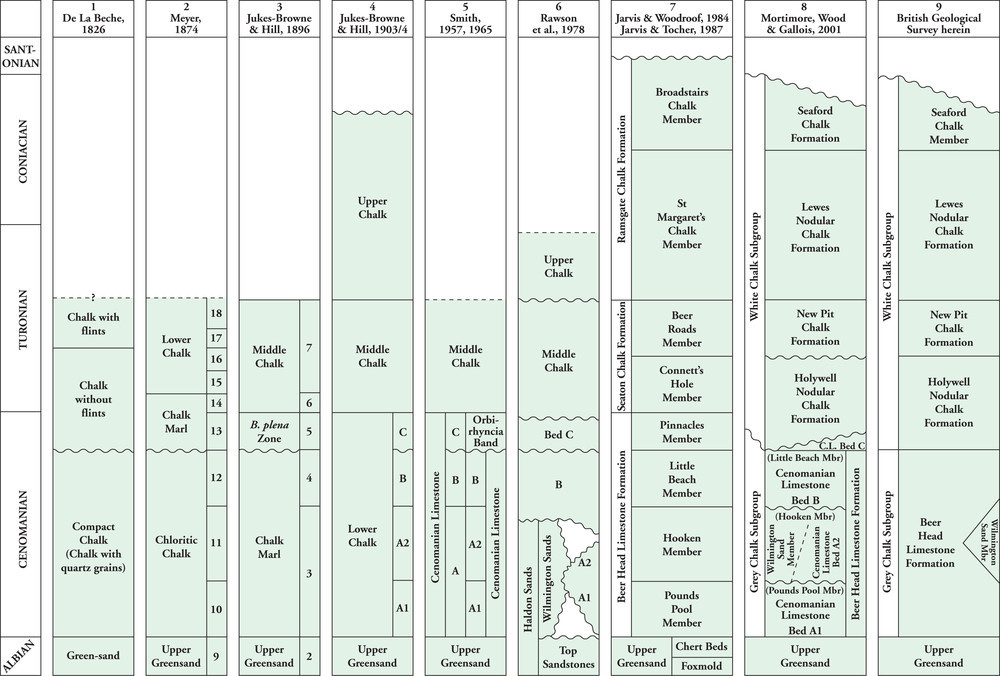
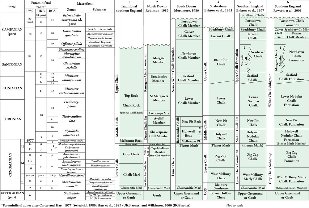
| 10:39, 9 June 2014 | P894998.jpg (file) |  |
197 KB | Dbk | Litho- biostratigraphical correlation chart for the Chalk Group of Southern England. From Research Report RR/05/01. | 1 |
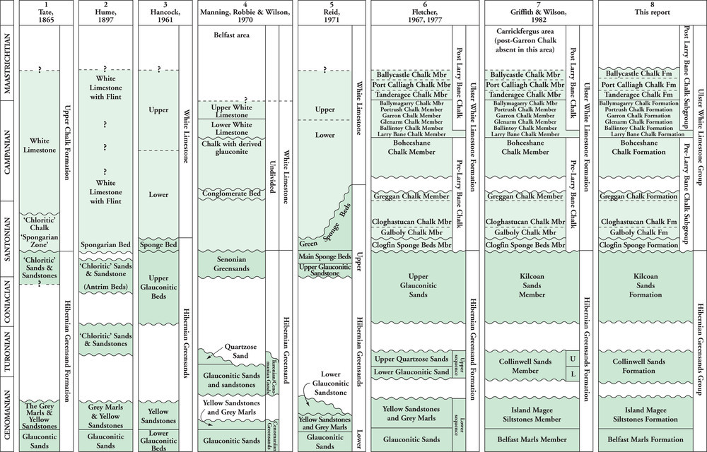
| 10:36, 9 June 2014 | P895011.jpg (file) |  |
211 KB | Dbk | The development of the terminology in the Ulster Cretaceous Province. | 1 |
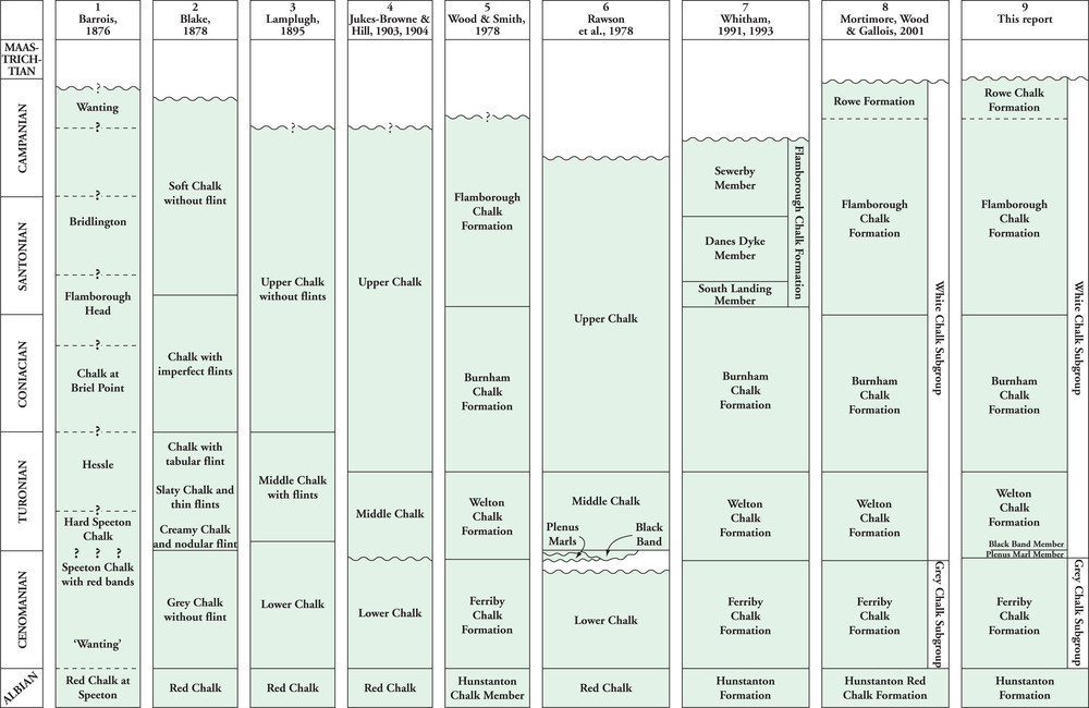
| 10:35, 9 June 2014 | P895008.jpg (file) |  |
135 KB | Dbk | The development of the terminology in the Northern Province. | 1 |
| 09:34, 9 June 2014 | P785848.jpg (file) |  |
43 KB | Dbk | Jurassic 200 to 145 million years ago | 1 |
| 09:34, 9 June 2014 | P785845.jpg (file) |  |
49 KB | Dbk | Carboniferous 359 to 299 million years ago | 1 |
| 09:33, 9 June 2014 | P785842.jpg (file) |  |
48 KB | Dbk | Ordovician 488 to 444 million years ago | 1 |
| 09:32, 9 June 2014 | P785839.jpg (file) |  |
44 KB | Dbk | Cretaceous 145 to 65 million years ago | 1 |
| 09:31, 9 June 2014 | P785836.jpg (file) |  |
207 KB | Dbk | Sedimentation in the Welsh Basin during the late Ordovician and early Silurian. | 1 |
| 09:30, 9 June 2014 | P785833.jpg (file) |  |
168 KB | Dbk | Terrane boundaries in the UK originating from the Caledonian and Variscan orogenic cycles. | 1 |
| 09:29, 9 June 2014 | P785826.jpg (file) |  |
101 KB | Dbk | Early Palaeogene palaeogeographical sketch map. | 1 |
| 09:28, 9 June 2014 | P785823.jpg (file) |  |
129 KB | Dbk | Mid Triassic palaeogeographical sketch map. | 1 |
| 09:27, 9 June 2014 | P785820.jpg (file) |  |
98 KB | Dbk | Carboniferous palaeogeographical sketch maps. c Early Westphalian | 1 |
| 09:26, 9 June 2014 | P785817.jpg (file) |  |
167 KB | Dbk | Carboniferous blocks and basins. | 1 |
| 09:26, 9 June 2014 | P785813.jpg (file) |  |
79 KB | Dbk | Cenozoic 65 million years ago to the present day | 1 |
| 09:25, 9 June 2014 | P785810.jpg (file) |  |
89 KB | Dbk | Carboniferous 359 to 299 million years ago | 1 |
| 09:24, 9 June 2014 | P785807.jpg (file) |  |
79 KB | Dbk | Lower Palaeozoic -Cambrian, Ordovician and Silurian 542 to 416 million years ago | 1 |
| 09:22, 9 June 2014 | P785803.jpg (file) |  |
147 KB | Dbk | The fault network that controlled Carboniferous sedimentation patterns. | 1 |
| 12:38, 6 June 2014 | P785797.jpg (file) |  |
110 KB | Dbk | How to determine the age of the rocks. | 1 |
| 12:37, 6 June 2014 | P667874.jpg (file) |  |
232 KB | Dbk | 1 | |
| 12:36, 6 June 2014 | P667864.jpg (file) |  |
145 KB | Dbk | 1 | |
| 12:35, 6 June 2014 | P667861.jpg (file) |  |
155 KB | Dbk | 1 | |
| 12:35, 6 June 2014 | P667857.jpg (file) |  |
184 KB | Dbk | 1 | |
| 12:34, 6 June 2014 | P649780.jpg (file) |  |
140 KB | Dbk | 1 | |
| 12:33, 6 June 2014 | P649396.jpg (file) |  |
245 KB | Dbk | 1 | |
| 12:32, 6 June 2014 | P601562.jpg (file) |  |
227 KB | Dbk | Volcanic breccia of the Charnwood Lodge Volcanic Formation (Maplewell Group, Charnian Supergroup, showing large andesite blocks, at the 'Bomb Rocks' locality, Charnwood Lodge. | 1 |
| 12:31, 6 June 2014 | P580475.jpg (file) |  |
207 KB | Dbk | Layered Inner Gabbro (F) cut by a later granite sheet. Druim Hain, Cuillin Centre, Skye. | 1 |
| 12:30, 6 June 2014 | P579282.jpg (file) |  |
179 KB | Dbk | Section in cliff at St Audrie's Bay, North Somerset Coast, looking eastwards. Shows the gradational boundary between interbedded red and green mudstones of the upper part of the Sidmouth Mudstone Formation, and the interbedded grey, green and pale brow... | 1 |
| 12:29, 6 June 2014 | P549553.jpg (file) |  |
350 KB | Dbk | Didymograptus, because of its general shape have been called 'tuning fork' graptolites, although there has been considerable debate about whether the animal lived with its branches (stipes) hanging downwards or whether it was a V-shape. These graptolit... | 1 |
| 12:28, 6 June 2014 | P547039.jpg (file) |  |
225 KB | Dbk | Conglomerate and sandstone of the Rova Head Conglomerate Formation. | 1 |
| 12:27, 6 June 2014 | P545612.jpg (file) |  |
137 KB | Dbk | View of Salisbury Crags and Edinburgh Castle. Edinburgh Castle Rock, a 345 Million year old volcanic neck viewed from above the Radical Road to the quarried scarp of well jointed, intrusive dolerite sill of Salisbury Crags. | 1 |
| 12:23, 6 June 2014 | P506771.jpg (file) |  |
138 KB | Dbk | Durness, Caithness. Entrance to Smoo Cave from cliffs above. | 1 |
| 12:22, 6 June 2014 | P225312.jpg (file) |  |
357 KB | Dbk | Magheramorne Quarry, County Antrim. Looking S. Section at Magheramorne Quarry. Tertiary basalt lavas resting on Chalk (Upper Cretaceous). | 1 |
| 12:21, 6 June 2014 | P223200.jpg (file) |  |
289 KB | Dbk | Castle Folds, a small mesa on Orton Knott with the Eden Valley and Alston Block in the background. Limestone pavement on the Knife Scar Limestone at Castle Folds. Limestone pavement on the Knife Scar Limestone about 40 m. above the base of that formation. | 1 |
| 12:20, 6 June 2014 | P222330.jpg (file) |  |
271 KB | Dbk | Crag Lough and Highfield Crags, Roman Wall. North-facing scarp of the Whin Sill ponding back the lake which probably occupies the site of a once far more extensive glacial lake. Flat ground to the right underlain by peat and alluvium. Note gaps in the ... | 1 |
| 12:17, 6 June 2014 | P220426.jpg (file) |  |
409 KB | Dbk | Brighouse, 3 km. S. of Borgue. Looking NE. S1 cleavage in Carghidown Formation, Hawick Group. | 1 |
| 12:16, 6 June 2014 | P219672.jpg (file) |  |
398 KB | Dbk | Viewpoint from Glen Torridon Road, looking S. into unnamed river valley. Hummocky moraines of probable Loch Lomond Readvance age. Glen Torridon. | 1 |
| 11:54, 6 June 2014 | P211084.jpg (file) |  |
588 KB | Dbk | Crawley Church is typical of most older parish churches in Britain being constructed almost completely from locally available materials, in this case sandstone from the Upper Tunbridge Wells Sand Formation and clay ironstone from the Weald Clay Formati... | 1 |
| 11:54, 6 June 2014 | P209677.jpg (file) |  |
213 KB | Dbk | View north-east from Bwlch-y-Clwydd along Cwmparc. A typical small coal mining village, Cwmparc, showing ribbon-development along the valley from its confluence at Treorchy (right middle distance) with the Rhondda Fawr. On the hillslopes lines of old c... | 1 |
| 11:53, 6 June 2014 | P064460.jpg (file) |  |
465 KB | Dbk | N. of Carstairs, looking SW. Carstairs Kames, view of sand and gravel ridges, peaty hollows and workings of Eastend Pit. | 1 |
| 11:52, 6 June 2014 | P018619.jpg (file) |  |
226 KB | Dbk | Douglas Bay, Isle of Man. Very thin (-thin) bedded sandstone and mudstone of Lonan Formation. | 1 |
| 11:51, 6 June 2014 | P008440.jpg (file) |  |
243 KB | Dbk | Kirkmabreck Quarry, Creetown. Microdiorite dykes in metasandstone above granite (Bench 3) looking north-east. Microdiorite dykes, approximately bed-parallel in the darker metasediment (see D3920-D3921 for details) above the contact (left of, and above ... | 1 |
| 11:50, 6 June 2014 | P008228.jpg (file) |  |
287 KB | Dbk | Craig y Benglog. Looking N. Bedded hyalocastite', associated with pillow lavas on Craig y Benglog. Benglog Volcanic Formation. This massive unit has a very limited vertical and lateral extent. The massive lower part consists of lapilli-sized fragments ... | 1 |
| 11:49, 6 June 2014 | P008157.jpg (file) |  |
193 KB | Dbk | Coastal cliff, 1 m. SSW of Upper Borth. Harp Rock'. The base of Aberystwyth Grits is taken here at the bottom of the lowest of the three prominent turbidites. | 1 |
| 11:48, 6 June 2014 | P007923.jpg (file) |  |
401 KB | Dbk | South Stack. Folded schists of the Mona Complex. These Precambrian rocks exhibit corrugation in the softer beds and vertical foliation in the harder ones. | 1 |
| 11:47, 6 June 2014 | P007523.jpg (file) |  |
189 KB | Dbk | High Cup Gill. Looking S. Whin Sill pinnacle on north side of High Cup Gill, showing rude columnar jointing. | 1 |
| 11:46, 6 June 2014 | P007262.jpg (file) |  |
129 KB | Dbk | 2 km. SE of Llanberis on A 4086. Llyn Peris and the Llanberis Pass. Massive outcrops of folded Bronllwyd Grit on the steep slopes behind the cottage. | 1 |