File list
Jump to navigation
Jump to search
This special page shows all uploaded files.
| Date | Name | Thumbnail | Size | User | Description | Versions |
|---|---|---|---|---|---|---|
| 15:26, 2 October 2014 | Northern EnglandRG fig4.jpg (file) | 69 KB | Dbk | Schematic cross-section of the geology of Northern England extending from the Cheviot Hills to County Durham. The alignment of the section and key are shown in Figure 1. | 1 | |
| 15:18, 2 October 2014 | P689653.jpg (file) |  |
164 KB | Dbk | Terraced hillside created by strata of the Yoredale Group at Blagill, near Alston, Cumbria. | 1 |
| 15:17, 2 October 2014 | P222366.jpg (file) |  |
312 KB | Dbk | Prudhamstone Quarry. Quarrying of the massive sandstone above the Four Fathom Limestone has exposed the overlying sandstones, siltstones which form a number of minor cyclothems. There are also some thin coals and impure limestones. The base of the Grea... | 1 |
| 15:16, 2 October 2014 | P222329.jpg (file) |  |
319 KB | Dbk | Housesteads Crags from Cuddy Crags. Scarp and dip-slopes of the Whin Sill protruding through elongate ridges of boulder clay. Sewingshields Crags on horizon in centre just over 1000 ft. Broomlee Lough to the left. Roman Wall capping the Whin crags. | 1 |
| 15:15, 2 October 2014 | P220606.jpg (file) |  |
298 KB | Dbk | West Chevington East Extension Opencast Site, 1 km. NW of Widdrington. West Chevington East Extension Opencast Site, Northumberland. General view, looking east. The back (east) wall of the site is about 70 m. high and exposes coal seams from the Bottom... | 1 |
| 15:14, 2 October 2014 | P005109.jpg (file) |  |
263 KB | Dbk | N. slopes of Harter Fell. Looking N. Lakeland central fells. The high, craggy peaks of Sca Fell, Scafell Pike, Ill Crag, Bowfell and Crinkle Crags are of glacially moulded Borrowdale Volcanic Group rocks. Faint bedding can be discerned in both Ill Crag... | 1 |
| 15:12, 2 October 2014 | Northern EnglandRG fig6.jpg (file) |  |
304 KB | Dbk | Sherwood Sandstone at Ousby in the Vale of Eden, Cumbria. | 1 |
| 15:11, 2 October 2014 | Northern England fig3.jpg (file) | 57 KB | Dbk | Schematic cross-section of the geology of Northern England extending from the Solway Firth to north Lancashire. The alignment of the section and key are shown in Figure 1. | 1 | |
| 15:11, 2 October 2014 | Northern EnglandRG fig2.jpg (file) | 74 KB | Dbk | Schematic cross-section of the geology of Northern England extending from the Irish Sea to North Sea. The alignment of the section and key are shown in Figure 1. | 1 | |
| 15:10, 2 October 2014 | Northern EnglandRG fig1.jpg (file) |  |
326 KB | Dbk | Geological map showing the range and distribution of different rock types in Northern England. The extent of Northern England region is identified on the inset map of the United Kingdom. | 1 |
| 14:55, 1 October 2014 | England RG.jpg (file) |  |
396 KB | Dbk | 1 | |
| 10:39, 4 August 2014 | Citizenscience.jpg (file) |  |
25 KB | Pdbe | Distribution of mySoil soil property information contributions | 1 |
| 11:24, 8 July 2014 | P780611.jpg (file) |  |
342 KB | Jeth1 | Temporary excavation exposing clay-with-flints [SU 32469 52350]. | 1 |
| 17:07, 4 July 2014 | Pentland Hills.jpg (file) |  |
115 KB | Scotfot | A view of the Pentland Hills looking North from Scald Law. By Bob McIntosh. | 1 |
| 16:10, 4 July 2014 | Lothian Geology cover.jpg (file) |  |
9 KB | Scotfot | The front cover of: Lothian Geology: An Excursion Guide by A. D. McAdam and Euan Clarkson | 1 |
| 15:53, 4 July 2014 | P005962.jpg (file) |  |
246 KB | Scotfot | Hutton's Section, Salisbury Craigs, Holyrood Park. Classic locality associated with James Hutton; shows intrusive features at base of Salisbury Craigs sill; teschenite chilled by sediment; sediments broken, twisted and baked by intrusion. | 1 |
| 17:38, 3 July 2014 | Salisbury Crags.jpg (file) |  |
106 KB | Scotfot | An image of Salisbury Crags viewed from Blackford Hill. Photograph by Bob McIntosh. | 1 |
| 17:28, 3 July 2014 | Arthurs Seat excursion map.jpg (file) |  |
75 KB | Scotfot | A map showing the numbered localities on the Arthurs Seat excursion | 1 |
| 17:07, 3 July 2014 | British Regional Geology areas map.jpg (file) |  |
101 KB | Scotfot | The map shows the boundaries of the BGS British Regional Geology areas | 1 |
| 09:49, 3 July 2014 | EGSlogo bw.jpg (file) |  |
556 KB | Dbk | 1 | |
| 12:24, 19 June 2014 | P535767.jpg (file) |  |
749 KB | Dbk | Cross-bedded, pale-coloured fluvial sandstone and brighter orange, poorly bedded aeolian sandstone of the Helsby Sandstone Formation (Sherwood Sandstone Group) at Hilbre Island in the Dee estuary, Mersyside. | 1 |
| 10:52, 19 June 2014 | P212668.jpg (file) |  |
865 KB | Dbk | A major fault separates the Malvern Hills (Neoproterozoic and Lower Palaeozoic rock) from the younger and lower lying Triassic of the Worcester Basin seen in the distance. | 1 |
| 10:43, 19 June 2014 | P213896.jpg (file) |  |
1.1 MB | Dbk | Heavitree Breccia of the Exeter Group. Note the small Neptunean dyke infilled with sand and truncated against the overlying bed, Exeter. | 1 |
| 10:40, 19 June 2014 | P220615.jpg (file) |  |
1.22 MB | Dbk | Brockram, Appleby Group, Saltom Bay, Whitehaven. | 1 |
| 09:56, 19 June 2014 | P550159.jpg (file) |  |
385 KB | Dbk | Reverted to version as of 09:51, 19 June 2014 | 3 |
| 08:52, 19 June 2014 | P220632.jpg (file) |  |
925 KB | Dbk | Cliffs formed by Triassic strata of the Sherwood Sandstone Group at St Bee's Head, Cumbria. | 1 |
| 08:49, 19 June 2014 | D05347.jpg (file) |  |
848 KB | Dbk | 1 | |
| 08:47, 19 June 2014 | GS1039.jpg (file) |  |
1.22 MB | Dbk | Deep-water, hemipelagic limestone with thin mudstone interbeds from the Craven Group (Bowland Shale Formation), Scarlett Point, Isle of Man. | 1 |
| 08:39, 19 June 2014 | P064426.jpg (file) |  |
411 KB | Dbk | 'Hutton's Unconformity': at Siccar Point, near Cockburnspath, Berwickshire, where Upper Devonian pebbly sandstone of the Stratheden Group discordantly overlies Lower Silurian sandstone turbidites of the Gala Group. | 1 |
| 07:59, 19 June 2014 | P785805.jpg (file) |  |
80 KB | Dbk | 1 | |
| 14:31, 17 June 2014 | Phone pics 061.jpg (file) |  |
3.5 MB | Jeth1 | Glacial features in the area. | 1 |
| 12:46, 12 June 2014 | P571797.jpg (file) |  |
62 KB | Jeth1 | Ardvreck Group (Eriboll Formation) quartzite on the summit ridge of Arkle, Sutherland. | 1 |
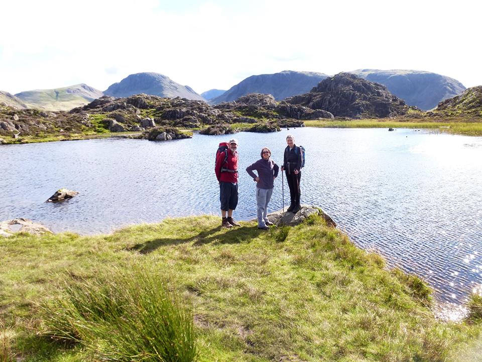
| 09:51, 12 June 2014 | Innominate Tarn.jpg (file) |  |
142 KB | Testuser | 1 | |
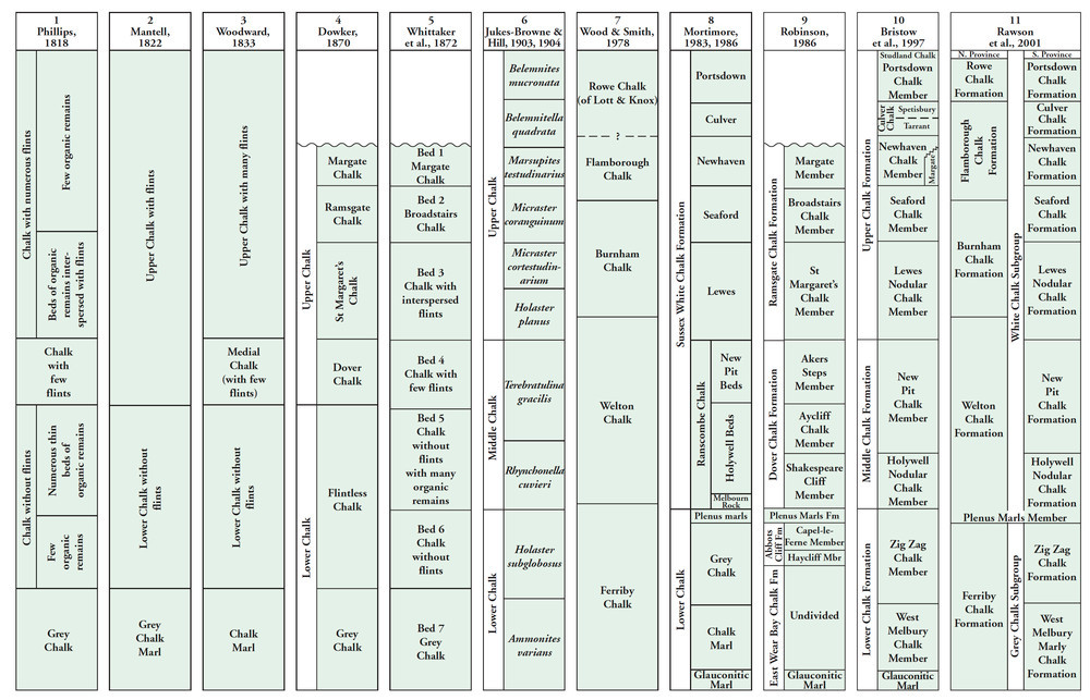
| 11:43, 11 June 2014 | P900807.jpg (file) |  |
204 KB | Dbk | Terminology applied to the Chalk of England. From Research Report RR/05/01. | 1 |
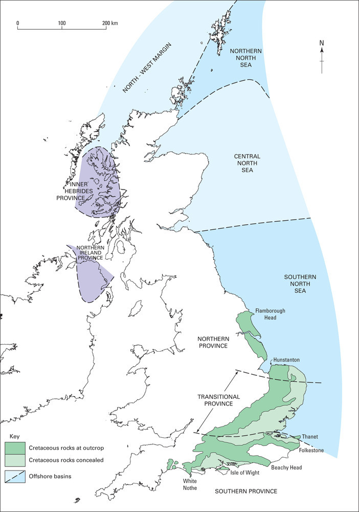
| 11:18, 11 June 2014 | P894997.jpg (file) |  |
114 KB | Dbk | Upper cretaceous province for the UK. | 1 |
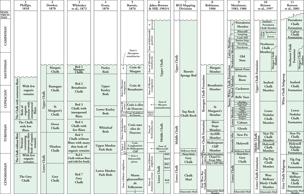
| 11:17, 11 June 2014 | P895005.jpg (file) |  |
194 KB | Dbk | The development of the terminology in the Southern Province. | 1 |
| 08:53, 11 June 2014 | P785917.jpg (file) |  |
180 KB | Dbk | Stages of cambering and mass movement of slopes in Middle Jurassic strata in the district. For key to bedrock units, see Geological Description. | 1 |
| 08:52, 11 June 2014 | P785846.jpg (file) |  |
46 KB | Dbk | Permian 299 to 251 million years ago | 1 |
| 08:51, 11 June 2014 | P785843.jpg (file) |  |
44 KB | Dbk | Silurian 444 to 416 million years ago | 1 |
| 08:50, 11 June 2014 | P785840.jpg (file) |  |
39 KB | Dbk | Cenozoic 65 million years ago to the present day | 1 |
| 08:49, 11 June 2014 | P785837.jpg (file) |  |
114 KB | Dbk | Palaeogeographical sketch map of deposition during the mid Silurian. | 1 |
| 08:49, 11 June 2014 | P785834.jpg (file) |  |
88 KB | Dbk | Sketch map to show the geography of England and Wales during the mid Cambrian. | 1 |
| 08:48, 11 June 2014 | P785828.jpg (file) |  |
127 KB | Dbk | Deposition of the Lambeth Group in the London Basin. | 1 |
| 16:19, 10 June 2014 | P785824.jpg (file) |  |
131 KB | Dbk | Mid Jurassic palaeogeographical sketch map. | 1 |
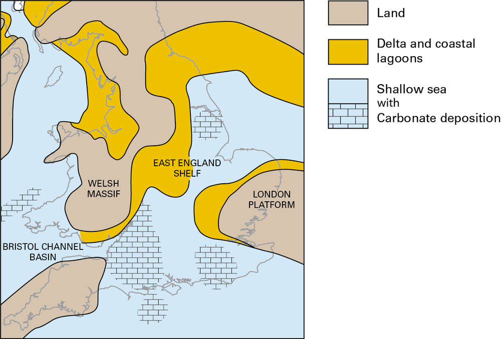
| 16:18, 10 June 2014 | P785821.jpg (file) |  |
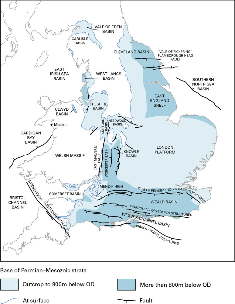
147 KB | Dbk | Permian and Mesozoic basins of England and Wales. | 1 |
| 16:17, 10 June 2014 | P785818.jpg (file) |  |
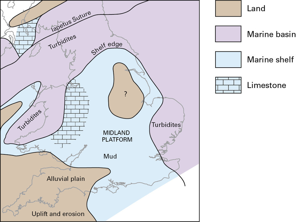
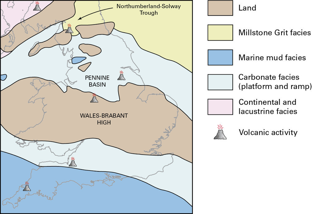
115 KB | Dbk | Carboniferous palaeogeographical sketch maps. a Early Visean | 1 |
| 16:16, 10 June 2014 | P785815.jpg (file) |  |
106 KB | Dbk | Early Devonian palaeogeographical sketch map. | 1 |
| 16:16, 10 June 2014 | P785811.jpg (file) |  |
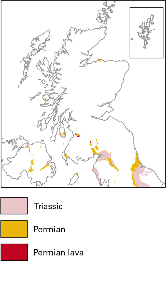
72 KB | Dbk | Permian and Triassic Including the New Red Sandstone Supergroup 299 to 200 million years ago | 1 |
| 16:15, 10 June 2014 | P785808.jpg (file) |  |
84 KB | Dbk | Caledonian Orogeny and associated magmatism | 1 |
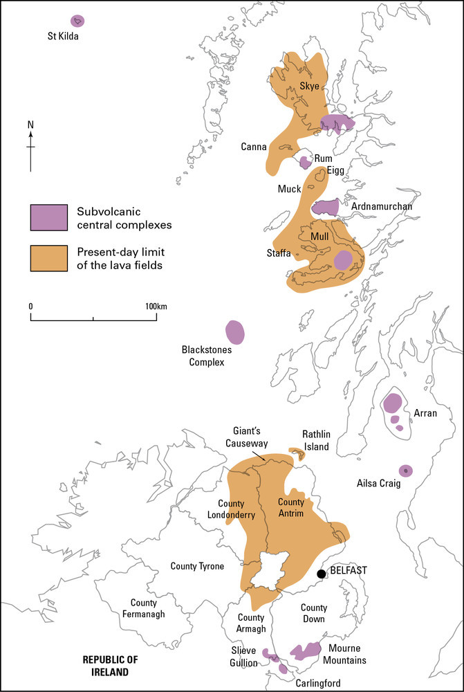
| 16:14, 10 June 2014 | P785804.jpg (file) |  |
120 KB | Dbk | Present-day distribution of lava fields and subvolcanic complexes of the Hebridean Province. | 1 |