File list
Jump to navigation
Jump to search
This special page shows all uploaded files.
| Date | Name | Thumbnail | Size | User | Description | Versions |
|---|---|---|---|---|---|---|
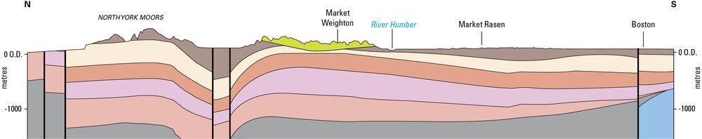
| 16:10, 7 October 2014 | P902255.jpg (file) | 40 KB | Dbk | Schematic cross-section through Eastern England | 1 | |
| 16:03, 7 October 2014 | P902254.jpg (file) |  |
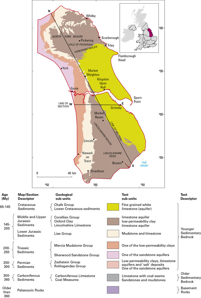
134 KB | Dbk | Geological map and key showing the range and distribution of different rock types in the Eastern England region, in relation to major towns and cities. The extent of the Eastern England region is defined on the inset map of the United Kingdom. | 1 |
| 15:50, 7 October 2014 | P902267.jpg (file) |  |
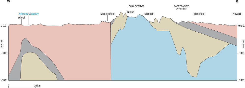
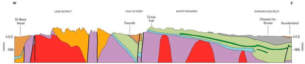
41 KB | Dbk | Schematic cross-section of the geology of The Pennines and adjacent areas from the Wirral to Nottinghamshire | 1 |
| 15:50, 7 October 2014 | P902266.jpg (file) |  |
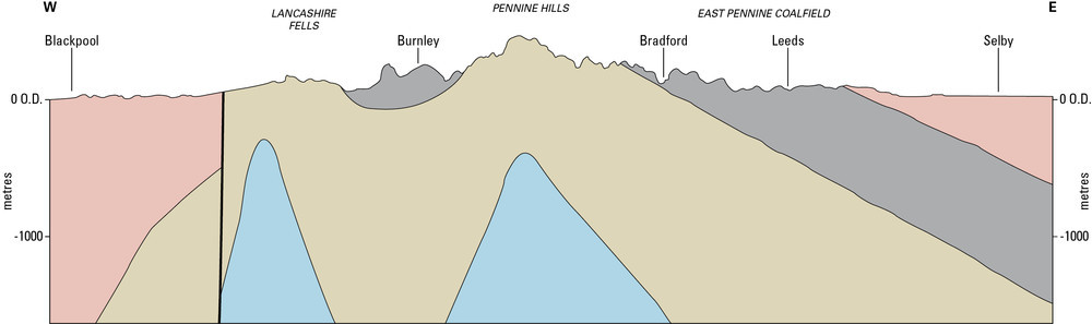
34 KB | Dbk | Schematic cross-section of the geology of The Pennines and adjacent areas from The Fylde to North Yorkshire | 1 |
| 15:47, 7 October 2014 | P902265.jpg (file) |  |
143 KB | Dbk | Geological sketch map showing the range and distribution of different rock types in The Pennines and adjacent areas | 1 |
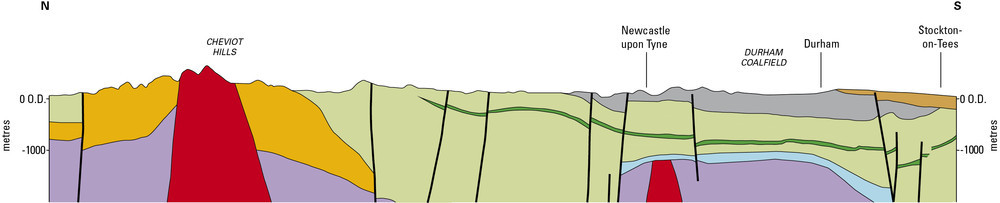
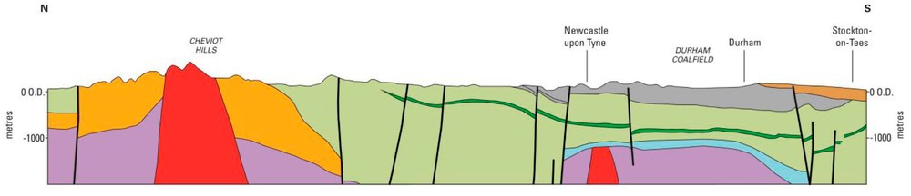
| 15:44, 7 October 2014 | P902282.jpg (file) | 39 KB | Dbk | Schematic cross-section of the geology of Northern England extending from the Cheviot Hills to County Durham | 1 | |
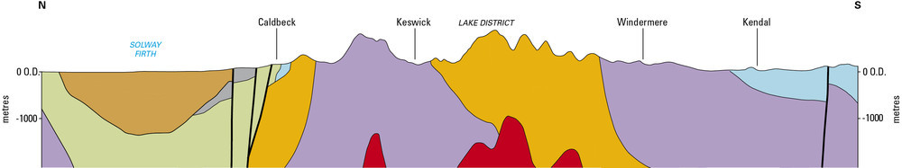
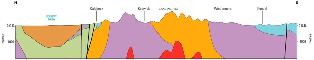
| 15:43, 7 October 2014 | P902259.jpg (file) | 32 KB | Dbk | Schematic cross-section of the geology of Northern England extending from the Solway Firth to north Lancashire | 1 | |
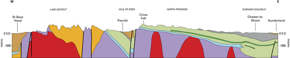
| 15:42, 7 October 2014 | P902261.jpg (file) | 43 KB | Dbk | Schematic cross-section of the geology of Northern England extending from the Irish Sea to North Sea | 1 | |
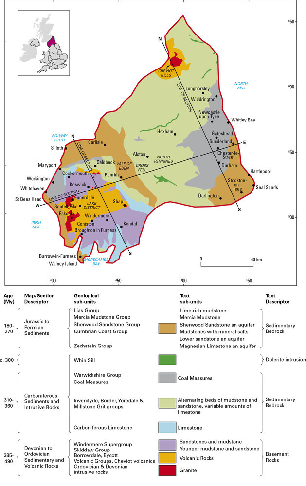
| 14:55, 7 October 2014 | P902262.jpg (file) |  |
137 KB | Dbk | Geological map showing the range and distribution of different rock types in Northern England. The extent of Northern England region is identified on the inset map of the United Kingdom | 1 |
| 14:57, 3 October 2014 | P595813.jpg (file) |  |
98 KB | Dbk | Typical landscape of the Yorkshire Wolds with rolling hills and deep valleys underlain by the Chalk. | 1 |
| 14:52, 3 October 2014 | P213703.jpg (file) |  |
204 KB | Dbk | The Lincolnshire Limestone, quarried near to Sleaford. | 1 |
| 14:50, 3 October 2014 | P708326.jpg (file) |  |
176 KB | Dbk | The Triassic Mercia Mudstone close to Newark contains seams of gypsum, a mineral that is quarried and used in the production of plaster. | 1 |
| 14:46, 3 October 2014 | P9202244.jpg (file) |  |
891 KB | Dbk | The distinctive landscape of the North York Moors with hard sedimentary bedrock layers capping the higher ground, and softer mudstones and other sediments forming the valley sides. | 1 |
| 17:21, 2 October 2014 | P774911.jpg (file) |  |
303 KB | Dbk | The Hard Bed Coal (0.8 m thick), seen in the left of the photo, is underlain by a pale grey ganister and seatclay palaeosol. The Stanningley Rock (2.8 m seen) is exposed at the top of the section, about 30 m above the Hard Bed Coal. | 1 |
| 17:20, 2 October 2014 | P596266.jpg (file) |  |
125 KB | Dbk | Scrooby Top Quarry. Rotheram Sand & Gravel Co. Ltd. About 11 km north-west of Worksop. A sand and gravel quarry over Triassic, Sherwood Sandstone Group. It is worked for building sand, concrete aggregate and decorative aggregate. | 1 |
| 17:19, 2 October 2014 | P223240.jpg (file) |  |
240 KB | Dbk | Sharow, near Ripon. Looking N. Subsidence hollow formed on February 1st 1982 after the dissolution of Permian gypsum. This hollow was initially about 11 m. in diameter and up to 9 m. deep. | 1 |
| 17:19, 2 October 2014 | P006206.jpg (file) |  |
167 KB | Dbk | Mam Tor. Looking W. Landslip-scar in Mam Tor Beds, with alternating sandstones and mudstones. | 1 |
| 17:18, 2 October 2014 | P005589.jpg (file) |  |
210 KB | Dbk | Gordale Scar, near Malham. Malham Formation. Gorge through Malham Formation limestones. The Cove Limestone (Holkerian) forms the lower massive bedded crags; the contract with the overlying Gordale Limestone (Asbian) is the prominent bedding plane visib... | 1 |
| 17:17, 2 October 2014 | P902243.jpg (file) |  |
34 KB | Dbk | Schematic cross-section of the geology of The Pennines and adjacent areas from the Wirral to Nottinghamshire. | 1 |
| 17:17, 2 October 2014 | P902242.jpg (file) |  |
29 KB | Dbk | Schematic cross-section of the geology of The Pennines and adjacent areas from The Fylde to North Yorkshire. | 1 |
| 17:16, 2 October 2014 | P902241.jpg (file) |  |
117 KB | Dbk | Geological sketch map showing the range and distribution of different rock types in The Pennines and adjacent areas. The extent of the region is identified on the inset map of the United Kingdom. | 1 |
| 16:56, 2 October 2014 | P902240.jpg (file) |  |
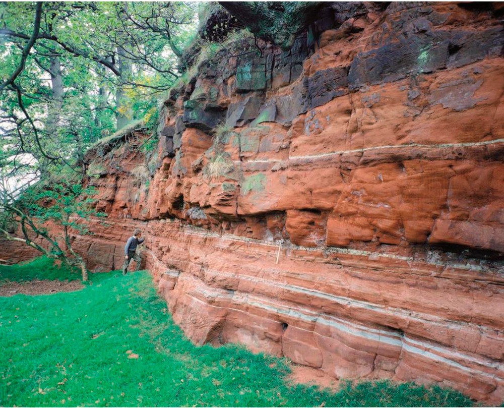
279 KB | Dbk | Sherwood Sandstone at Ousby in the Vale of Eden, Cumbria. | 1 |
| 16:55, 2 October 2014 | P902239.jpg (file) | 32 KB | Dbk | Schematic cross-section of the geology of Northern England extending from the Cheviot Hills to County Durham. | 1 | |
| 16:55, 2 October 2014 | P902238.jpg (file) | 25 KB | Dbk | Schematic cross-section of the geology of Northern England extending from the Solway Firth to north Lancashire. | 1 | |
| 16:54, 2 October 2014 | P902237.jpg (file) | 33 KB | Dbk | Schematic cross-section of the geology of Northern England extending from the Irish Sea to North Sea. | 1 | |
| 16:54, 2 October 2014 | P902236.jpg (file) |  |
114 KB | Dbk | Geological map showing the range and distribution of different rock types in Northern England. The extent of Northern England region is identified on the inset map of the United Kingdom. | 1 |
| 16:26, 2 October 2014 | Northern EnglandRG fig4.jpg (file) | 69 KB | Dbk | Schematic cross-section of the geology of Northern England extending from the Cheviot Hills to County Durham. The alignment of the section and key are shown in Figure 1. | 1 | |
| 16:18, 2 October 2014 | P689653.jpg (file) |  |
164 KB | Dbk | Terraced hillside created by strata of the Yoredale Group at Blagill, near Alston, Cumbria. | 1 |
| 16:17, 2 October 2014 | P222366.jpg (file) |  |
312 KB | Dbk | Prudhamstone Quarry. Quarrying of the massive sandstone above the Four Fathom Limestone has exposed the overlying sandstones, siltstones which form a number of minor cyclothems. There are also some thin coals and impure limestones. The base of the Grea... | 1 |
| 16:16, 2 October 2014 | P222329.jpg (file) |  |
319 KB | Dbk | Housesteads Crags from Cuddy Crags. Scarp and dip-slopes of the Whin Sill protruding through elongate ridges of boulder clay. Sewingshields Crags on horizon in centre just over 1000 ft. Broomlee Lough to the left. Roman Wall capping the Whin crags. | 1 |
| 16:15, 2 October 2014 | P220606.jpg (file) |  |
298 KB | Dbk | West Chevington East Extension Opencast Site, 1 km. NW of Widdrington. West Chevington East Extension Opencast Site, Northumberland. General view, looking east. The back (east) wall of the site is about 70 m. high and exposes coal seams from the Bottom... | 1 |
| 16:14, 2 October 2014 | P005109.jpg (file) |  |
263 KB | Dbk | N. slopes of Harter Fell. Looking N. Lakeland central fells. The high, craggy peaks of Sca Fell, Scafell Pike, Ill Crag, Bowfell and Crinkle Crags are of glacially moulded Borrowdale Volcanic Group rocks. Faint bedding can be discerned in both Ill Crag... | 1 |
| 16:12, 2 October 2014 | Northern EnglandRG fig6.jpg (file) |  |
304 KB | Dbk | Sherwood Sandstone at Ousby in the Vale of Eden, Cumbria. | 1 |
| 16:11, 2 October 2014 | Northern England fig3.jpg (file) | 57 KB | Dbk | Schematic cross-section of the geology of Northern England extending from the Solway Firth to north Lancashire. The alignment of the section and key are shown in Figure 1. | 1 | |
| 16:11, 2 October 2014 | Northern EnglandRG fig2.jpg (file) | 74 KB | Dbk | Schematic cross-section of the geology of Northern England extending from the Irish Sea to North Sea. The alignment of the section and key are shown in Figure 1. | 1 | |
| 16:10, 2 October 2014 | Northern EnglandRG fig1.jpg (file) |  |
326 KB | Dbk | Geological map showing the range and distribution of different rock types in Northern England. The extent of Northern England region is identified on the inset map of the United Kingdom. | 1 |
| 15:55, 1 October 2014 | England RG.jpg (file) |  |
396 KB | Dbk | 1 | |
| 11:39, 4 August 2014 | Citizenscience.jpg (file) |  |
25 KB | Pdbe | Distribution of mySoil soil property information contributions | 1 |
| 12:24, 8 July 2014 | P780611.jpg (file) |  |
342 KB | Jeth1 | Temporary excavation exposing clay-with-flints [SU 32469 52350]. | 1 |
| 18:07, 4 July 2014 | Pentland Hills.jpg (file) |  |
115 KB | Scotfot | A view of the Pentland Hills looking North from Scald Law. By Bob McIntosh. | 1 |
| 17:10, 4 July 2014 | Lothian Geology cover.jpg (file) |  |
9 KB | Scotfot | The front cover of: Lothian Geology: An Excursion Guide by A. D. McAdam and Euan Clarkson | 1 |
| 16:53, 4 July 2014 | P005962.jpg (file) |  |
246 KB | Scotfot | Hutton's Section, Salisbury Craigs, Holyrood Park. Classic locality associated with James Hutton; shows intrusive features at base of Salisbury Craigs sill; teschenite chilled by sediment; sediments broken, twisted and baked by intrusion. | 1 |
| 18:38, 3 July 2014 | Salisbury Crags.jpg (file) |  |
106 KB | Scotfot | An image of Salisbury Crags viewed from Blackford Hill. Photograph by Bob McIntosh. | 1 |
| 18:28, 3 July 2014 | Arthurs Seat excursion map.jpg (file) |  |
75 KB | Scotfot | A map showing the numbered localities on the Arthurs Seat excursion | 1 |
| 18:07, 3 July 2014 | British Regional Geology areas map.jpg (file) |  |
101 KB | Scotfot | The map shows the boundaries of the BGS British Regional Geology areas | 1 |
| 10:49, 3 July 2014 | EGSlogo bw.jpg (file) |  |
556 KB | Dbk | 1 | |
| 13:24, 19 June 2014 | P535767.jpg (file) |  |
749 KB | Dbk | Cross-bedded, pale-coloured fluvial sandstone and brighter orange, poorly bedded aeolian sandstone of the Helsby Sandstone Formation (Sherwood Sandstone Group) at Hilbre Island in the Dee estuary, Mersyside. | 1 |
| 11:52, 19 June 2014 | P212668.jpg (file) |  |
865 KB | Dbk | A major fault separates the Malvern Hills (Neoproterozoic and Lower Palaeozoic rock) from the younger and lower lying Triassic of the Worcester Basin seen in the distance. | 1 |
| 11:43, 19 June 2014 | P213896.jpg (file) |  |
1.1 MB | Dbk | Heavitree Breccia of the Exeter Group. Note the small Neptunean dyke infilled with sand and truncated against the overlying bed, Exeter. | 1 |
| 11:40, 19 June 2014 | P220615.jpg (file) |  |
1.22 MB | Dbk | Brockram, Appleby Group, Saltom Bay, Whitehaven. | 1 |