File list
Jump to navigation
Jump to search
This special page shows all uploaded files.
| Date | Name | Thumbnail | Size | User | Description | Versions |
|---|---|---|---|---|---|---|
| 19:15, 23 February 2015 | CramondShoreExcursionMap.jpg (file) |  |
448 KB | Scotfot | Cramond shore excursion map | 1 |
| 18:04, 23 February 2015 | SouthQueensferryShoreExcursionMap.jpg (file) |  |
369 KB | Scotfot | South Queensferry shore - excursion map | 1 |
| 17:46, 23 February 2015 | P000199.jpg (file) |  |
148 KB | Scotfot | Westwood Bing 'The Five Sisters', West Calder viewed from the south-west. West Lothian. Five conical spoil heaps of spent oil-shale known as an oil-shale bing. The freshly mined raw oil-shales were heated in retorts to produce shale-oil for distillatio... | 1 |
| 16:02, 22 February 2015 | NorthEskInlierExcursionMap.jpg (file) |  |
574 KB | Scotfot | North Esk Inlier excursion map | 1 |
| 15:56, 22 February 2015 | PentlandHillsTorphinToBonalyTowerExcursionMap.jpg (file) |  |
732 KB | Scotfot | Pentland Hills - Torphin to Bonaly Tower - excursion map. | 1 |
| 15:44, 22 February 2015 | PentlandHillsBavelawToLoganleeExcursionMap.jpg (file) |  |
998 KB | Scotfot | Pentland Hills Bavelaw To Loganlee Reservoir excursion map. | 1 |
| 22:30, 21 February 2015 | RiverNorthEskExcursionMap.jpg (file) |  |
380 KB | Scotfot | River North Esk excursion map. | 1 |
| 22:22, 21 February 2015 | P005865.jpg (file) |  |
218 KB | Scotfot | Fairy Castle; junction of Bladdering Cleugh and Back Burn, 3.6 km. upstream of Oldhamstocks. Dyke in Lower Old Red Sandstone conglomerate (Great Conglomerate). Conglomerate adjacent to dyke baked and very resistant, dyke generally rotten, note sharply ... | 1 |
| 22:14, 21 February 2015 | LammermuirDeansExcursionMap.jpg (file) |  |
221 KB | Scotfot | Lammermuir Deans excursion map | 1 |
| 19:53, 21 February 2015 | SiccarPointExcursionMap.jpg (file) |  |
439 KB | Scotfot | Siccar Point excursion map. | 1 |
| 18:33, 21 February 2015 | P001526.jpg (file) |  |
157 KB | Scotfot | Catcraig Limekiln, Dunbar, East Lothian. The kiln is used for the production of lime by mixing limestone and coal, firing it, and drawing of the lime at the base. It was used for centuries by medieval builders for binding masonry and lightening interio... | 1 |
| 18:04, 21 February 2015 | CatcraigExcursionMap.jpg (file) |  |
400 KB | Scotfot | Catcraig - excursion map. | 1 |
| 23:33, 20 February 2015 | DunbarExcursionMap.jpg (file) |  |
439 KB | Scotfot | Dunbar - excursion map | 1 |
| 23:09, 20 February 2015 | DunbarBelhavenAndTheParadeExcursionMap.jpg (file) |  |
470 KB | Scotfot | Dunbar, Belhaven and the Parade - excursion map | 1 |
| 22:50, 16 February 2015 | P001088.jpg (file) |  |
139 KB | Scotfot | The Harbour, Dunbar, East Lothian. Cliffs cut into volcanic vent agglomerate of Calciferous Sandstone Measures age. Ruins of Dunbar Castle, on a raised beach platform. North Berwick Law phonolitic trachyte plug in distance. The vent, one of several in ... | 1 |
| 22:40, 16 February 2015 | P001296.jpg (file) |  |
218 KB | Scotfot | Oblique aerial view of Dunbar, looking from the west-north-west. East Lothian. West Bay on the right front is a large vent agglomerate crossed by dykes/joints with bedded red sandstones above; Dunbar Castle and harbour entrance is situated on vent aggl... | 1 |
| 20:13, 16 February 2015 | P000690.jpg (file) |  |
114 KB | Scotfot | Traprain Law, a phonolite laccolith intruded into Lower Carboniferous sediments and volcanic rocks which form the drift-covered foreground. Taken from Balfour Monument at Blaikie Heugh, 3 km. south-west of East Linton. | 1 |
| 20:01, 16 February 2015 | GarletonHillsVolcanicRocksExcursionMap.jpg (file) |  |
741 KB | Scotfot | Garleton Hills, excursion map | 1 |
| 19:26, 16 February 2015 | NorthBerwickYellowCraigToCheeseBayExcursionMap.jpg (file) |  |
342 KB | Scotfot | Yellow Craig to Cheese Bay excursion map. | 1 |
| 22:42, 15 February 2015 | NorthBerwickCantyBayExcursionMap.jpg (file) |  |
435 KB | Scotfot | North Berwick to Canty Bay excursion map. From Lothian Geology: an excursion guide. Edinburgh : Edinburgh Geological Society, 1996. Map 9. | 1 |
| 22:35, 15 February 2015 | KilspindieShoreExcursionMap.jpg (file) |  |
327 KB | Scotfot | Kilspindie shore - an excursion From Lothian Geology: an excursion guide. Edinburgh : Edinburgh Geological Society, 1996. Map 8. | 1 |
| 22:27, 15 February 2015 | GrantonAndWardieShoreExcursionMap.jpg (file) |  |
591 KB | Scotfot | Granton And Wardie Shore excursion map. From Lothian Geology: an excursion guide. Edinburgh : Edinburgh Geological Society, 1996. | 1 |
| 22:20, 15 February 2015 | BlackfordHillExcursionMap.jpg (file) |  |
315 KB | Scotfot | Blackford Hill and Dreghorn excursion map. From Lothian Geology and excursion guide. Edinburgh : Edinburgh Geological Society, 1996. | 1 |
| 20:43, 15 February 2015 | BuildingStomesOfEdinburghMap.jpg (file) |  |
289 KB | Scotfot | Building stones of Edinburgh excursion map | 1 |
| 20:21, 15 February 2015 | EdinburghCityCentreBuildingStonesExcursion.jpg (file) |  |
1.49 MB | Scotfot | Building stones of Edinburgh excursion map.From Lothian geology :an Excursion guide. | 1 |
| 21:40, 7 February 2015 | P002937.jpg (file) |  |
285 KB | Scotfot | Oblique aerial view of Edinburgh Castle from the south. A classic example of crag and tail featuring. The Castle is built on a basaltic plug of Lower Carboniferous age intruded into Cementstone Group (Dinantian) strata. The Castle Hill, together with t... | 1 |
| 21:24, 7 February 2015 | Water of Leith Valley.png (file) |  |
71 KB | Scotfot | Water of Leith Valley. Map from Lothian geology: an excursion guide. Edinburgh : Edinburgh Geological Society, 1986. | 1 |
| 20:41, 7 February 2015 | P001324.jpg (file) |  |
253 KB | Scotfot | Oblique aerial view of Calton Hill and the Arthur's Seat volcano, looking from the north-west. | 1 |
| 14:00, 30 January 2015 | P239116.jpg (file) |  |
1.07 MB | Dbk | Exposed during excavation in 1901, mudstone beds of the Cotham Formation are overlain by the prominent limestone of the White Lias Formation, succeeded by interbedded mudstone and limestone of the basal part of the Blue Lias Formation. Approximate loca... | 1 |
| 16:29, 10 October 2014 | P902263.jpg (file) | 35 KB | Dbk | Schematic cross-section through the geology of Northern Ireland. | 1 | |
| 16:27, 10 October 2014 | P902264.jpg (file) |  |
169 KB | Dbk | Geological sketch map showing the range and distribution of different rock types in Northern Ireland, in relation to the major towns and cities. The extent of the Northern Ireland region is shown on the inset map of the United Kingdom. | 1 |
| 16:24, 10 October 2014 | P662435.jpg (file) |  |
178 KB | Dbk | Alternating limestones and shales of Porthkerry Formation (Jurassic). Dunraven. | 1 |
| 16:23, 10 October 2014 | P662426.jpg (file) |  |
148 KB | Dbk | Carboniferous limestone outcrop along the escarpment of Mynydd Eglwysseg, Llangollen. | 1 |
| 16:22, 10 October 2014 | P210903.jpg (file) |  |
176 KB | Dbk | Brecon Beacons. Looking E. Brecon Beacons. North face of Pen y Fan. | 1 |
| 16:21, 10 October 2014 | P006965.jpg (file) |  |
207 KB | Dbk | Crib Goch ridge. Looking WSW. Bedding and cleavage planes prominent in Ordovician volcanics. Crib Goch ridge with 'pinnacles'. Snowdon left background, Crib Y Ddysgl right background. | 1 |
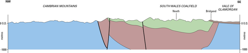
| 16:19, 10 October 2014 | P902275.jpg (file) | 28 KB | Dbk | Schematic cross-section of the geology of South Wales. | 1 | |
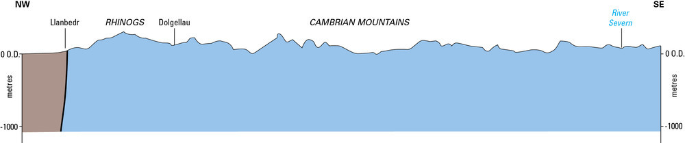
| 16:19, 10 October 2014 | P902273.jpg (file) | 22 KB | Dbk | Schematic cross-section of the geology of Central Wales. | 1 | |
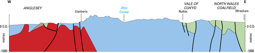
| 16:18, 10 October 2014 | P902276.jpg (file) | 37 KB | Dbk | Schematic cross-section of the geology of Anglesey and Northwest Wales. | 1 | |
| 16:17, 10 October 2014 | P902274.jpg (file) |  |
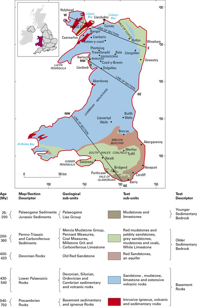
148 KB | Dbk | Geological map showing the range and distribution of different rock types in Wales, in relation to the topography and major towns and cities. Wales is identified on the inset map of the United Kingdom. | 1 |
| 15:00, 10 October 2014 | P902268.jpg (file) |  |
165 KB | Dbk | Geological sketch map showing the range and distribution of different rock types in the South West England Region, in relation to the major towns and cities. The extent of the region is shown on the inset map of the United Kingdom. | 1 |
| 14:59, 10 October 2014 | P902610.jpg (file) |  |
235 KB | Dbk | Highly deformed metamorphic rock of the Start Point Complex. | 1 |
| 14:58, 10 October 2014 | P209965.jpg (file) |  |
173 KB | Dbk | A Dartmoor granite tor, Blackingstone Rock, Devon. Blackingstone Rock, a Dartmoor granite tor. Looking east-south-east. A granite tor on the northern margins of the Dartmoor granite. The coarse porphyritic granite is cut by steep joints and also by the... | 1 |
| 14:57, 10 October 2014 | P212763.jpg (file) |  |
158 KB | Dbk | Wild Pear Beach. Overfolds in Wild Pear Slates (Ilfracombe Slates). Close to the major fault which separates Hangman Grits from Ilfracombe Slates the Wild Pear Slates are overfolded. The north-facing, fairly tight overfolds are strongly cleaved in thei... | 1 |
| 14:56, 10 October 2014 | P211236.jpg (file) |  |
168 KB | Dbk | Warren Beach, Hartland Quay. Looking NE. Coastal structure. Upright chevron folds in sandstones, siltstones and shales of the Crackington Formation. | 1 |
| 14:55, 10 October 2014 | P211134.jpg (file) |  |
159 KB | Dbk | View from Easton Barton, Lapford. Looking E. Topography on Carboniferous Rocks. Typical well-rounded sandstone features in the Bude Formation; the low-lying area behind the buildings is underlain by silty shales. Formerly, the sandstones were extensive... | 1 |
| 14:53, 10 October 2014 | P781352.jpg (file) |  |
242 KB | Dbk | The Budleigh Salterton Pebble Beds at Town Farm Pit, near Burlscombe. Height of face about 5 m. | 1 |
| 14:48, 10 October 2014 | P211333.jpg (file) |  |
179 KB | Dbk | Watchet. Looking SE. Gypsiferous Keuper Marl. In the foreground gypsiferous Keuper Marl is visible. Arietites bucklandi Zone beds of the Lias are present in the higher cliffs and are faulted into contact with the red 'marls'. Scree of Lias debris obscu... | 1 |
| 14:43, 10 October 2014 | P902269.jpg (file) |  |
32 KB | Dbk | Schematic cross-section of the underlying geology of the Southwest region from Exmoor to Start Point. | 1 |
| 14:42, 10 October 2014 | P902270.jpg (file) |  |
44 KB | Dbk | Schematic cross-section of the geology of the Southwest region from St Just to Crewkerne. | 1 |
| 11:39, 10 October 2014 | P902609.jpg (file) |  |
212 KB | Dbk | The De la Beche Unconformity. Horizontally bedded Jurassic limestones (Inferior Oolite) rest upon grey folded Carboniferous Limestone, Vallis Vale, near Frome. | 1 |