File list
Jump to navigation
Jump to search
This special page shows all uploaded files.
| Date | Name | Thumbnail | Size | User | Description | Versions |
|---|---|---|---|---|---|---|
| 17:07, 11 March 2015 | 058 fig2.jpg (file) |  |
851 KB | Dbk | Onshore geology based on the BGS 1:625 000 onshore geological map | 1 |
| 17:07, 11 March 2015 | 058 fig1.jpg (file) |  |
1.09 MB | Dbk | Location of modelled area, outlined in red | 1 |
| 16:40, 9 March 2015 | DolphintonExcursionMap.jpg (file) |  |
184 KB | Scotfot | Dolphinton - excursion map. | 1 |
| 16:39, 9 March 2015 | CarlopsExcursionMap.jpg (file) |  |
208 KB | Scotfot | Carlops - excursion map. | 1 |
| 16:37, 9 March 2015 | NoblehousePillowLavas.jpg (file) |  |
198 KB | Scotfot | Pillow lavas. | 1 |
| 16:35, 9 March 2015 | BroadlawExcursionMap.jpg (file) |  |
221 KB | Scotfot | Broadlaw - excursion map | 1 |
| 16:32, 9 March 2015 | NoblehouseExcursionMap.jpg (file) |  |
324 KB | Scotfot | Noblehouse, Lamancha - excursion map. | 1 |
| 16:14, 9 March 2015 | HeriotInnerleithenExcursionMap.jpg (file) |  |
785 KB | Scotfot | Heriot and Innerleithen - excursion map | 1 |
| 13:36, 9 March 2015 | 029 fig13.jpg (file) |  |
720 KB | Dbk | 3D view of the calculated rockhead elevation surface calculated as an ascii grid with a 100m cell size. The highest elevations are in red and the lowest in blue, vertical exaggeration is x 10. | 1 |
| 13:33, 9 March 2015 | 029 fig12.jpg (file) |  |
605 KB | Dbk | The GSI3D model of bedrock and superficial deposits, viewed from the southwest. | 1 |
| 13:33, 9 March 2015 | 029 fig11.jpg (file) |  |
473 KB | Dbk | The bedrock units to the base of the Chalk (in green) as modelled in GSI3D, viewed from the southwest. The legend is shown in Figure 2. | 1 |
| 13:22, 9 March 2015 | 029 fig10.jpg (file) |  |
236 KB | Dbk | The western fault area with faults in the model labelled | 1 |
| 13:22, 9 March 2015 | 029 fig9.jpg (file) |  |
383 KB | Dbk | The eastern fault area with faults in the model labelled | 1 |
| 13:21, 9 March 2015 | 029 fig8.jpg (file) |  |
188 KB | Dbk | Overview of fault pattern, with the eastern (a) and western (b) faulted areas shown | 1 |
| 13:20, 9 March 2015 | 029 fig7.jpg (file) |  |
2.31 MB | Dbk | Framework of cross-sections used to construct the GSI3D model | 1 |
| 12:21, 9 March 2015 | 029 fig6.jpg (file) |  |
1.53 MB | Dbk | The LithoFrame 10 HS2 route model area, shown in blue stipple | 1 |
| 12:20, 9 March 2015 | 029 fig5.jpg (file) |  |
2.78 MB | Dbk | The Thames Gateway models, shown in blue hatching | 1 |
| 12:19, 9 March 2015 | O29 fig4.jpg (file) |  |
2.3 MB | Dbk | Location of borehole logs consulted in model construction | 1 |
| 23:10, 8 March 2015 | EildonHillsExcursionMap.jpg (file) |  |
612 KB | Scotfot | Eildon Hills excursion map. | 1 |
| 22:59, 8 March 2015 | ChiefswoodMap.jpg (file) |  |
741 KB | Scotfot | Chiefswood. | 1 |
| 22:57, 8 March 2015 | MelroseAbbeyPlan.jpg (file) |  |
268 KB | Scotfot | Melrose Abbey. | 1 |
| 22:55, 8 March 2015 | DryburghAbbeyPlan.jpg (file) |  |
287 KB | Scotfot | Dryburgh Abbey. | 1 |
| 22:53, 8 March 2015 | BorderAbbeysExcursionMap.jpg (file) |  |
700 KB | Scotfot | Border Abbeys excursion map. | 1 |
| 19:37, 8 March 2015 | JedburghMelroseKelsoExcursionmap.jpg (file) |  |
690 KB | Scotfot | Jedburgh Melrose Kelso - excursion map. | 1 |
| 19:26, 8 March 2015 | RaecleuchExcursionMap.jpg (file) |  |
264 KB | Scotfot | Raecleuch - excursion map. | 1 |
| 19:24, 8 March 2015 | BedshielExcursionMap.jpg (file) |  |
188 KB | Scotfot | Bedshiel - excursion map. | 1 |
| 18:37, 8 March 2015 | WhiteadderWaterExcursionMap.jpg (file) |  |
248 KB | Scotfot | Whiteadder Water - excursion map | 1 |
| 16:45, 8 March 2015 | BerwickExcursionMap.jpg (file) |  |
332 KB | Scotfot | Berwick-upon-Tweed - excursion map. | 1 |
| 16:44, 8 March 2015 | BerwickEelwellFoldsDiagram.jpg (file) |  |
370 KB | Scotfot | Overthrust and overturned folds at Eelwell, Berwick-upon-Tweed | 1 |
| 16:42, 8 March 2015 | BerwickSpittalSouthExcursionMap.jpg (file) |  |
336 KB | Scotfot | Spittal south - excursion map. | 1 |
| 16:41, 8 March 2015 | BerwickSpittalCentralExcursionMap.jpg (file) |  |
386 KB | Scotfot | Spittal central - excursion map. | 1 |
| 16:40, 8 March 2015 | BerwickSpittalNorthExcursionMap.jpg (file) |  |
365 KB | Scotfot | Spittal North - excursion map | 1 |
| 10:00, 8 March 2015 | BurnmouthCarboniferousFossils.jpg (file) |  |
541 KB | Scotfot | Carboniferous fossis from the Burnmouth area. Schizodus axiformis (Phillips) x0.7 Visean Canobius ramsayi Traquair [after Traquair] x1; Visean | 1 |
| 09:33, 8 March 2015 | LambertonExcursionMap.jpg (file) |  |
593 KB | Scotfot | Lamberton excursion map | 1 |
| 09:32, 8 March 2015 | Burnmouth.jpg (file) |  |
486 KB | Scotfot | Burnmouth - excursion map. | 1 |
| 22:48, 7 March 2015 | P005900.jpg (file) |  |
218 KB | Scotfot | Eyemouth Fort. SW view. Glacial deposits. Boulder clay rests on bedded gravel with thick band of bedded sand. On left the lower beds abut against pale purple lavas of Lower Old Red Sandstone age, marking the south-east limit of a channel. The drift dep... | 1 |
| 22:43, 7 March 2015 | EyemouthExcursionMap.jpg (file) |  |
429 KB | Scotfot | Eyemouth - Excursion Map | 1 |
| 21:18, 7 March 2015 | P005896.jpg (file) |  |
144 KB | Scotfot | Linkim Kip. Sea stack. Stack in greywackes of Linkim Beds (Silurian). The beds have a low inverted dip to north-north-west and are traversed by a drag-fold whose axial planes dip at about 50 degrees to north-north-east. This fold possibly induced by a... | 1 |
| 21:12, 7 March 2015 | ColdinghamExcursionMap.jpg (file) |  |
329 KB | Scotfot | Coldingham - an excursion map. | 1 |
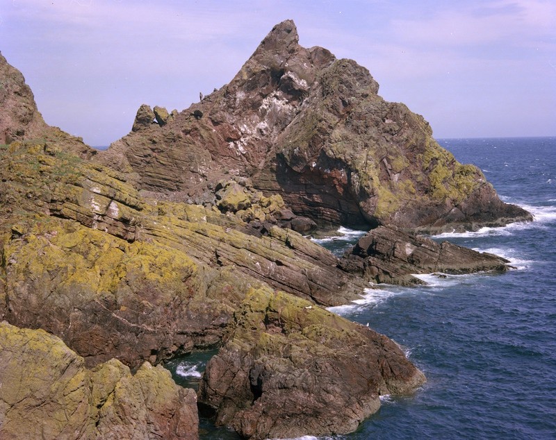
| 20:41, 7 March 2015 | P005893.jpg (file) |  |
182 KB | Scotfot | St. Abb's Head, Horsecastle Bay. View N. Grits and lava. Bedded tuffaceous grits overlie massive lava in the foreground, and are overlain on the headland by a later flow with a clearly irregular base. Such interrelations of bedded grits are not uncommo... | 1 |
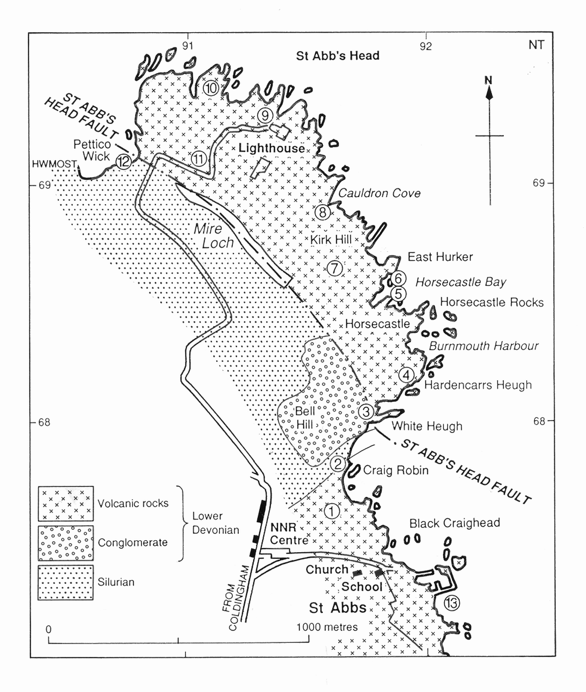
| 20:35, 7 March 2015 | StAbbsHeadExcursionMap.jpg (file) |  |
566 KB | Scotfot | St. Abb's Head Excursion map. | 1 |
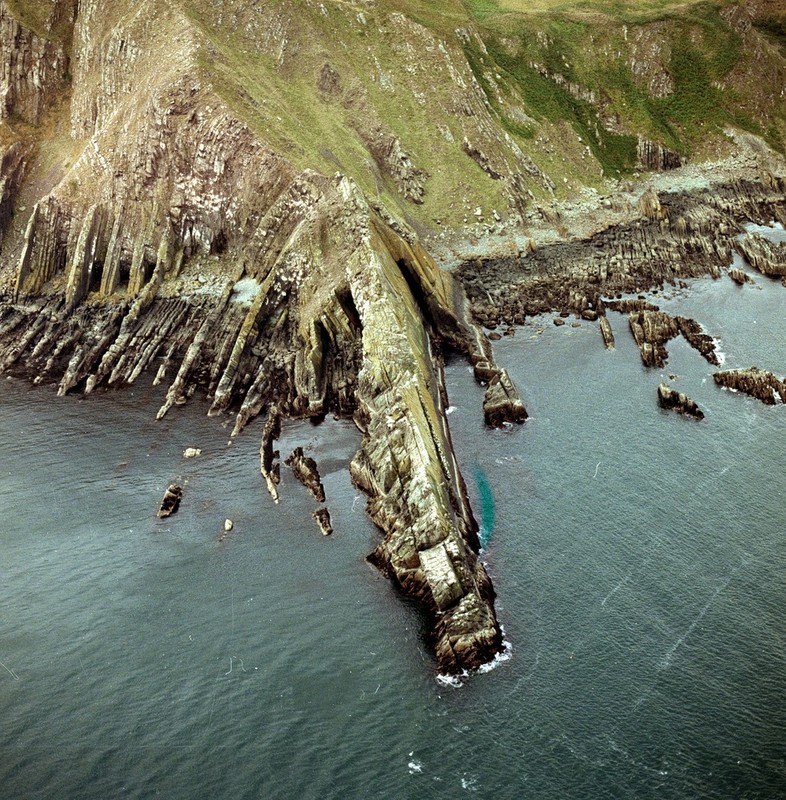
| 19:59, 7 March 2015 | P002932.jpg (file) |  |
281 KB | Scotfot | Oblique aerial view of the Berwickshire coast at Brander, 1.3 km. east of Fast Castle, Berwickshire. Anticline in Silurian rocks. View from the north-east of a spectacular anticline in Silurian (Llandovery) rocks at Brander, about 1.3 km. east of Fast... | 1 |
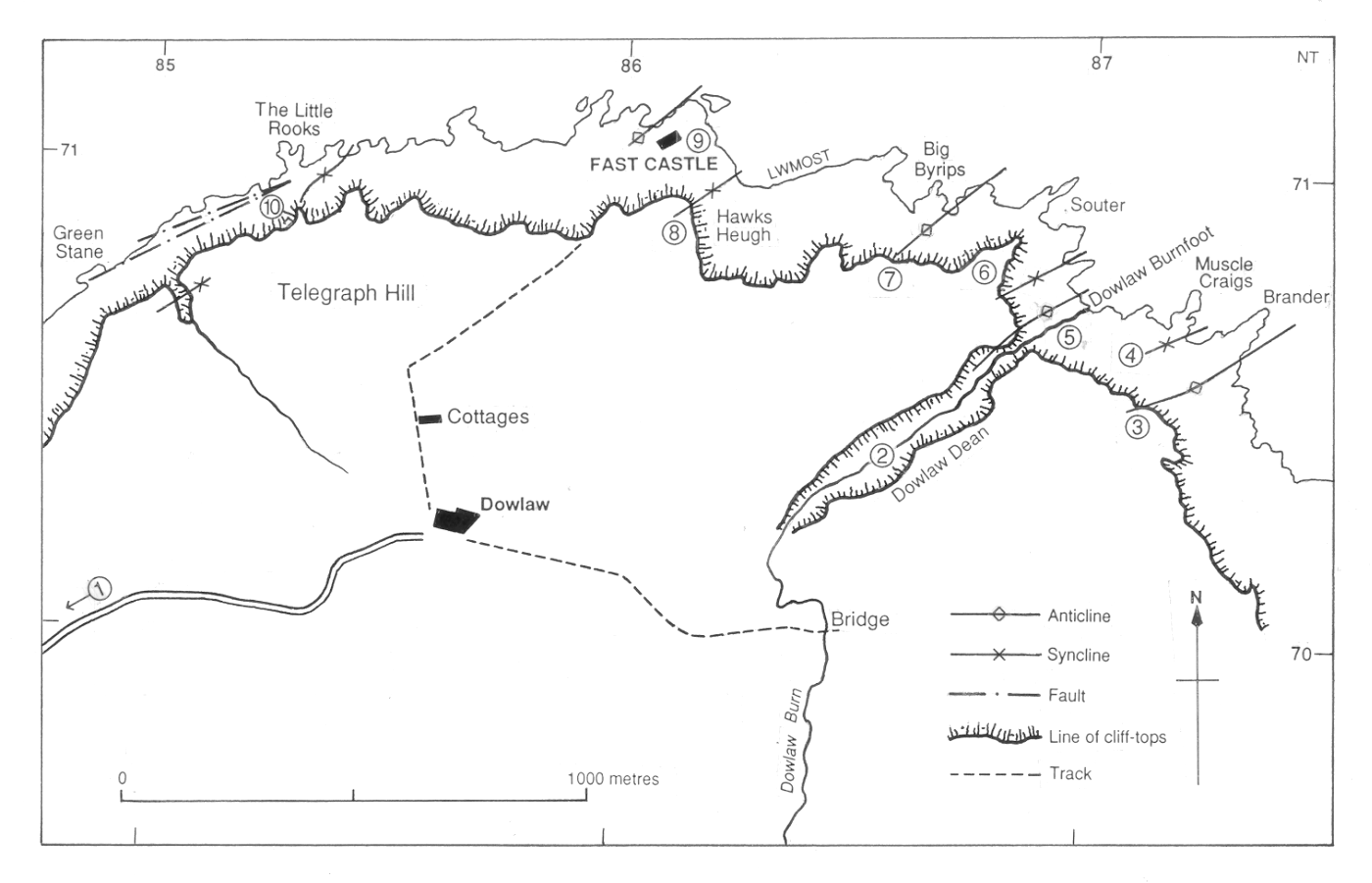
| 19:50, 7 March 2015 | FastCastleExcursionMap.png (file) |  |
338 KB | Scotfot | Fast Castle - an excursion map. | 1 |
| 13:19, 6 March 2015 | 029 fig2.jpg (file) |  |
1.92 MB | Dbk | 1: 50 000 scale geological map sheets corresponding to the model | 1 |
| 13:09, 6 March 2015 | 029 fig3.jpg (file) |  |
419 KB | Dbk | Superficial geological units modelled in GSI3D | 1 |
| 12:57, 6 March 2015 | OR14029 figure1.jpg (file) |  |
1.52 MB | Dbk | Location of the London model and component tiles. | 1 |
| 12:05, 6 March 2015 | BGS Welsh Bilingual.png (file) |  |
228 KB | Anapier | Welsh BGS Logo | 1 |
| 20:38, 23 February 2015 | BathgateHillsExcursionMap.jpg (file) |  |
563 KB | Scotfot | Bathgate Hills excursion map | 1 |
| 19:59, 23 February 2015 | RiverAvonAnExcursionSectionInPassageGroup.jpg (file) |  |
268 KB | Scotfot | Section in Passage Group | 1 |
| 19:54, 23 February 2015 | RiverAvonExcursionMap.jpg (file) |  |
388 KB | Scotfot | River Avon - excursion map | 1 |