File list
Jump to navigation
Jump to search
This special page shows all uploaded files.
| Date | Name | Thumbnail | Size | User | Description | Versions |
|---|---|---|---|---|---|---|
| 12:56, 8 July 2016 | OR16030 geomagnetic.jpg (file) |  |
128 KB | Dbk | User created page with UploadWizard | 1 |
| 12:56, 8 July 2016 | OR16030 forecasters.jpg (file) |  |
87 KB | Dbk | User created page with UploadWizard | 1 |
| 12:56, 8 July 2016 | OR16030 Fort McMurray.jpg (file) |  |
60 KB | Dbk | User created page with UploadWizard | 1 |
| 12:56, 8 July 2016 | OR16030 flyers.jpg (file) |  |
149 KB | Dbk | User created page with UploadWizard | 1 |
| 12:56, 8 July 2016 | OR16030 evolution.jpg (file) |  |
82 KB | Dbk | User created page with UploadWizard | 1 |
| 12:56, 8 July 2016 | OR16030 errormodel.jpg (file) |  |
186 KB | Dbk | User created page with UploadWizard | 1 |
| 12:56, 8 July 2016 | OR16030 ellenclarke gemmakelly.jpg (file) |  |
117 KB | Dbk | User created page with UploadWizard | 1 |
| 12:56, 8 July 2016 | OR16030 declination.jpg (file) |  |
106 KB | Dbk | User created page with UploadWizard | 1 |
| 12:56, 8 July 2016 | OR16030 davekerridge.jpg (file) |  |
88 KB | Dbk | User created page with UploadWizard | 1 |
| 12:56, 8 July 2016 | OR16030 Cover.jpg (file) |  |
145 KB | Dbk | User created page with UploadWizard | 1 |
| 12:56, 8 July 2016 | OR16030 CYG.jpg (file) |  |
166 KB | Dbk | User created page with UploadWizard | 1 |
| 12:55, 8 July 2016 | OR16030 CiaranBeggan.jpg (file) |  |
73 KB | Dbk | User created page with UploadWizard | 1 |
| 12:55, 8 July 2016 | OR16030 ChrisTurbitt.jpg (file) |  |
95 KB | Dbk | User created page with UploadWizard | 1 |
| 12:55, 8 July 2016 | OR16030 Cheongyang.jpg (file) |  |
112 KB | Dbk | User created page with UploadWizard | 1 |
| 12:55, 8 July 2016 | OR16030 aurora.jpg (file) |  |
45 KB | Dbk | User created page with UploadWizard | 1 |
| 12:55, 8 July 2016 | OR16030 attendees.jpg (file) |  |
89 KB | Dbk | User created page with UploadWizard | 1 |
| 12:55, 8 July 2016 | OR16030 AlanThomson.jpg (file) |  |
101 KB | Dbk | User created page with UploadWizard | 1 |
| 12:55, 8 July 2016 | OR16030 ashleysmith.jpg (file) |  |
166 KB | Dbk | User created page with UploadWizard | 1 |
| 13:31, 1 July 2016 | OR16010fig6.jpg (file) |  |
70 KB | Dbk | 1 | |
| 16:26, 29 June 2016 | OR14063append3.png (file) |  |
178 KB | Dbk | 1 | |
| 16:25, 29 June 2016 | OR14063ELC 30 P5.gif (file) |  |
232 KB | Dbk | Photo ELC_30 P5: Steep coastal edge south of Gullane Point. © John Gordon. | 1 |
| 16:24, 29 June 2016 | OR14063ELC 30 P3.gif (file) |  |
337 KB | Dbk | Photo ELC_30 P3: Raised shorelines at Luffness Links Golf Course. © John Gordon. | 1 |
| 16:24, 29 June 2016 | OR14063ELC 30 P2.gif (file) |  |
293 KB | Dbk | Photo ELC_30 P2: Glacial erratic block on an intertidal shore platform near Gullane Point. The platform is cut across dipping Carboniferous strata. © John Gordon. | 1 |
| 16:22, 29 June 2016 | OR14063fig33.gif (file) |  |
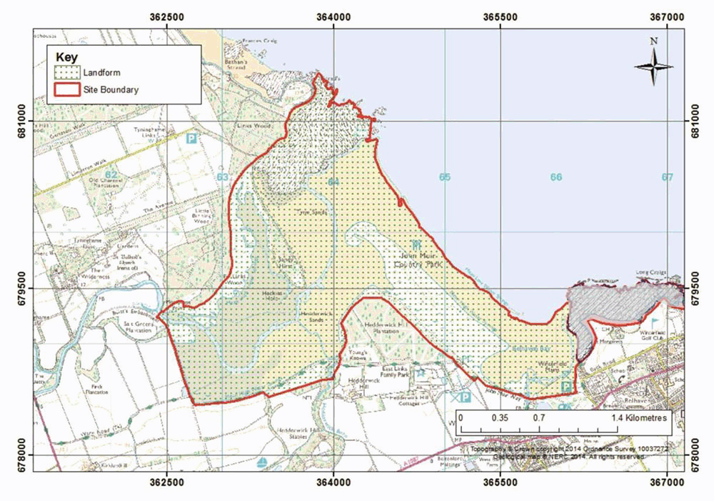
289 KB | Dbk | Figure 33 Tyne Estuary Map. The site boundary includes the landform assemblage of the modern estuary and bay as an integral coastal geomorphology unit. The adjacent bedrock and Quaternary site at Dunbar (ELC_4) is shown for reference (transparent gr... | 1 |
| 16:21, 29 June 2016 | OR14063fig32.gif (file) |  |
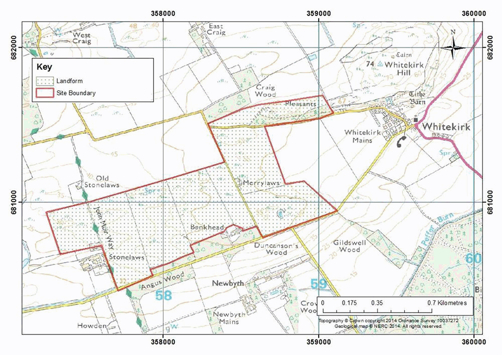
259 KB | Dbk | Figure 32 Whitekirk Location Map. The site boundary is drawn to include a representative area of ice-moulded bedrock. | 1 |
| 16:20, 29 June 2016 | OR14063fig30.gif (file) |  |
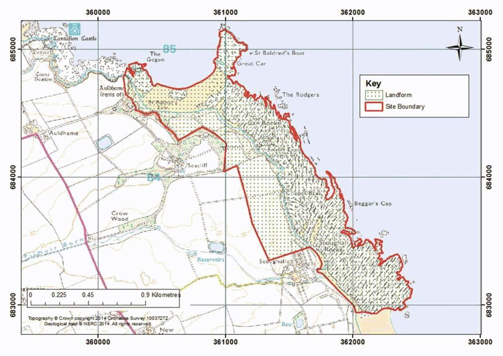
233 KB | Dbk | Figure 30 Seacliff-Scoughall Shore Location Map. The site boundary covers the landforms comprising shore platforms, backing cliffs, and postglacial raised beaches. | 1 |
| 16:19, 29 June 2016 | OR14063fig23.gif (file) |  |
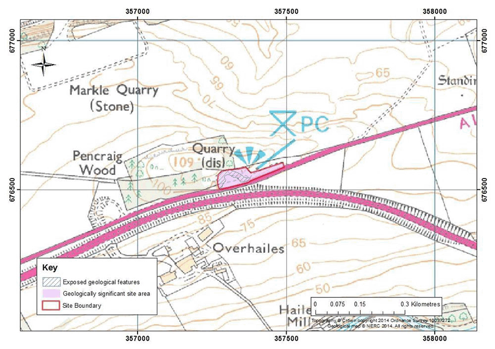
289 KB | Dbk | Figure 23 Pencraig Wood Location Map. Site boundary has been drawn to include rock exposures (blue hatched areas) and also site access and viewpoints (drawn as geologically significant site area). | 1 |
| 16:18, 29 June 2016 | OR14063fig19.gif (file) |  |
254 KB | Dbk | Figure 19 Kilspindie Shore Location Map. The site boundary is drawn to include access along the edge of Kilspindie Golf course, as well as encapsulating local landforms (e.g. beaches) and the key rock exposures. This site is immediately adjacent to... | 1 |
| 16:17, 29 June 2016 | OR14063fig17.gif (file) |  |
244 KB | Dbk | Figure 17 Peppercraig Quarry Location Map. The site boundary includes the original extent of the quarry, which is historically and geologically significant due to its importance in providing building stone to the town of Haddington. Exposed rock is... | 1 |
| 16:16, 29 June 2016 | OR14063fig14.gif (file) |  |
101 KB | Dbk | Figure 14 Kippielaw Scarp Location Map. The site boundary has been drawn to include key exposures, and access to the site as well as suitable viewing distance of the natural surfaces (geologically significant area). | 1 |
| 15:23, 29 June 2016 | OR14063tab8.jpg (file) |  |
822 KB | Dbk | Table 8 Geological features present at the Geodiversity Sites. | 1 |
| 15:22, 29 June 2016 | OR14063tab7.jpg (file) |  |
1.25 MB | Dbk | Table 7 Summary of ratings for East Lothian Geodiversity sites (note 'Fm' is an abbreviation of Formation). Under 'Feature(s)' column, the feature of most interest is presented in bold text. | 1 |
| 15:18, 29 June 2016 | OR14063ELC 30 P7.jpg (file) |  |
72 KB | Dbk | Photo ELC_30 P7: Intertidal flats near the entrance to the Local Nature Reserve. © John Gordon. | 1 |
| 15:18, 29 June 2016 | OR14063ELC 30 P6.jpg (file) |  |
97 KB | Dbk | Photo ELC_30 P6: Saltmarsh and intertidal flats near the entrance to the Local Nature Reserve. © John Gordon. | 1 |
| 15:17, 29 June 2016 | OR14063ELC 30 P4.jpg (file) |  |
86 KB | Dbk | Photo ELC_30 P4: Sand dune system south of Gullane Point. © John Gordon. | 1 |
| 15:14, 29 June 2016 | OR14063ELC 30 P1.jpg (file) |  |
81 KB | Dbk | Photo ELC_30 P1: View north across Aberlady Bay from Kilspindie on the south shore. © John Gordon. | 1 |
| 15:13, 29 June 2016 | OR14063fig35.jpg (file) |  |
167 KB | Dbk | Figure 35 Aberlady Bay Map. The site boundary has been drawn to include the dominant intertidal portion of Aberlady Bay including sand flats, and the dune system. The site boundary is largely coincident with that of the Aberlady Bay Local Nature Re... | 1 |
| 15:13, 29 June 2016 | OR14063fig34.jpg (file) |  |
151 KB | Dbk | Figure 34 Gullane Bents Map. The site boundary includes the sand flats of Gullane Bay, the Gullane Bents dune system and backing cliff. The site boundary for the adjacent Gullane Shore bedrock/Quaternary site (ELC_13) to the west is included (ELC_30... | 1 |
| 15:11, 29 June 2016 | OR14063fig31.jpg (file) |  |
146 KB | Dbk | Figure 31 Thorntonloch Coast Location Map. The site boundary has been drawn to include the rock cliffs and intertidal shore platform. | 1 |
| 15:10, 29 June 2016 | OR14063fig29.jpg (file) |  |
131 KB | Dbk | Figure 29 Lochhouses Location Map. Suggested site boundary includes the field boundary surrounding the landform in which the tsunami deposits are found. | 1 |
| 15:09, 29 June 2016 | OR14063fig28.jpg (file) |  |
175 KB | Dbk | Figure 28 Kidlaw Erratic Location Map. The site boundary is drawn to include the main upstanding mass of limestone and its continuation below the adjacent moundy lower ground to the east as marked on the BGS 1:50k solid geology Sheet 33W. The site b... | 1 |
| 15:08, 29 June 2016 | OR14063fig27.jpg (file) |  |
178 KB | Dbk | Figure 27 Garleton Hills Location Map. The site boundary covers an area of erosional glacial landforms. The area contains numerous exposures of volcanic bedrock, but these have not been marked as they are already covered by SSSI designation. | 1 |
| 15:08, 29 June 2016 | OR14063fig26.jpg (file) |  |
118 KB | Dbk | Figure 26 Cheese Bay Location Map. The site boundary has been drawn to include the bedrock exposure containing the Shrimp Bed for which Cheese Bay is known. The adjacent intertidal zone and is also included due to its potential for containing fossil... | 1 |
| 15:07, 29 June 2016 | OR14063fig25.jpg (file) |  |
124 KB | Dbk | Figure 25 Kidlaw Quarry Location Map. The site boundary has been drawn to include the rock exposures within the quarry, and related access and viewpoints (geologically significant site areas). The site boundary for the Kidlaw Erratic (ELC_22) to the... | 1 |
| 15:06, 29 June 2016 | OR14063fig24.jpg (file) |  |
173 KB | Dbk | Figure 24 North Berwick Law Location Map. The site boundary includes the crag and tail feature of North Berwick Law and related bedrock exposures, only the proximal part of the landform 'tail' to the east is included. The site boundary coincides in... | 1 |
| 15:04, 29 June 2016 | OR14063fig21.jpg (file) |  |
173 KB | Dbk | Figure 21 Cockenzie and Port Seton Location Map. The site comprises bedrock exposed in shore platforms and adjacent areas of beach. Bedrock exposures likely to vary over time due to changes in beach morphology. Areas of the site important for access... | 1 |
| 15:03, 29 June 2016 | OR14063fig20.jpg (file) |  |
167 KB | Dbk | Figure 20 Prestonpans Shore Location Map. The site comprises areas of bedrock exposure (coastal rock platforms), and beaches. Bedrock exposure is likely to vary over time due to changes in beach morphology. Areas of the site important for access or... | 1 |
| 14:59, 29 June 2016 | OR14063fig18.jpg (file) |  |
131 KB | Dbk | Figure 18 Gullane Shore Location Map. The site area comprises bedrock exposures in shore platforms and coastal landforms including inlets and areas of beach in the immediate vicinity of the main rock outcrops, The exact area of bedrock exposure is l... | 1 |
| 14:57, 29 June 2016 | OR14063fig16.jpg (file) |  |
143 KB | Dbk | Figure 16 Craigs Quarry Location Map. The site boundary includes small areas of rock exposure, with a larger geologically significant area that incorporates the location of the old Craigs Quarry, and access paths to the site. | 1 |
| 14:56, 29 June 2016 | OR14063fig15.jpg (file) |  |
181 KB | Dbk | Figure 15 Dirleton Castle Location Map. The site boundary is drawn to include key exposures, access to the castle and grounds and coincides with the area of the Scheduled Ancient Monument. The castle itself is also considered to be part of the geolo... | 1 |