File list
Jump to navigation
Jump to search
This special page shows all uploaded files.
| Date | Name | Thumbnail | Size | User | Description | Versions |
|---|---|---|---|---|---|---|
| 11:45, 6 June 2014 | P007054.jpg (file) |  |
203 KB | Dbk | W. of Cwm Croesor. Acid (granophyre) sill forms main feature with cleaved mudstones on either side mostly hidden by grass. Cnicht summit in distance. | 1 |
| 11:44, 6 June 2014 | P006782.jpg (file) |  |
295 KB | Dbk | Flamborough Head. Looking WNW. Cliffs in Selwicks Bay. Well-bedded Upper Chalk with flints shows slight disturbance which has probably been caused by ice movement. In the background the cliffs are capped by landslipped Devensian glacial deposits. | 1 |
| 11:36, 6 June 2014 | P006254.jpg (file) |  |
146 KB | Dbk | Drabber Tor, Wolfscote Dale at confluence with Biggin Dale, Derbyshire/N. Staffs. Looking NW. Castellated crags flanking the southern part of Wolfscote Dale composed of well-bedded pelletal calcarenitic limestone with thin micritic limestones of Lower ... | 1 |
| 11:35, 6 June 2014 | P005990.jpg (file) |  |
208 KB | Dbk | Blindwells Opencast Site, Tranent. Limestone Coal Group strata, from Great Seam Coal to Four Foot Coal; shows small fault; variable overburden of glacial till; temporary spoil heap in far left, back-filled spoil near left. | 1 |
| 11:34, 6 June 2014 | P005775.jpg (file) |  |
346 KB | Dbk | Stair Hole Cove, West Lulworth. Looking E. Stair Hole. Junction of Lower Purbeck and Portland Stone. | 1 |
| 11:33, 6 June 2014 | P005554.jpg (file) |  |
242 KB | Dbk | Combs Quarry, Foredale. Looking W. Sub-Carboniferous unconformity. Steep, southwardly dipping Horton Formation laminated siltstones are overlain by horizontal, well-bedded Dinantian limestones. | 1 |
| 11:33, 6 June 2014 | P005147.jpg (file) |  |
175 KB | Dbk | Hollin House Tongue, Seathwaite, Duddon Valley, Cumbria. Typical thin parallel-bedded sub-aerial volcaniclastic rocks that show a great variation in size. | 1 |
| 11:32, 6 June 2014 | P002763.jpg (file) |  |
127 KB | Dbk | Ben Hope looking north-north-east from Alltnacaillich, Sutherland. Coarse feldspathic and siliceous Moine psammites dipping gently to the east intruded by the basic 'Ben Hope Sill'. The sill forms the long escarpment and can be traced for many miles an... | 1 |
| 11:31, 6 June 2014 | P001267.jpg (file) |  |
489 KB | Dbk | Oblique aerial view of Edinburgh Castle Rock and the Arthur's Seat volcano, looking from the west-north-west. In the foreground, Edinburgh Castle sits on dolerite plugging a Lower Carboniferous volcanic vent intruded into softer sedimentary rocks. Glac... | 1 |
| 11:30, 6 June 2014 | P001157.jpg (file) |  |
204 KB | Dbk | Looking south-west along the summit ridge of the 'Grey Corries' towards Aonach Beag (1234 m.). Glen Roy district, Lochaber. Well-bedded quartzites of the Glencoe Quartzite (Lochaber Subgroup) are well exposed with extensive areas of scree from frost-sh... | 1 |
| 11:29, 6 June 2014 | P001097.jpg (file) |  |
165 KB | Dbk | Bass Rock from Seacliff Harbour, East Lothian. The islet is a volcanic plug composed of a non-porphyritic, orthophyric, fairly coarse-grained phonolitic trachyte, an intrusion related to the Garleton Hills Volcanic Rocks. The rocks in the foreground ar... | 1 |
| 11:28, 6 June 2014 | P000965.jpg (file) |  |
162 KB | Dbk | Above the scarp lies a peaty platform composed of Cambrian Pipe Rock with some 'Fucoid' Beds at the eastern edge. Above the platform rises gneiss which has been carried on the combined Sole and Glencoul Thrust Planes and forms the main hill of Aird da ... | 1 |
| 11:27, 6 June 2014 | P000818.jpg (file) |  |
523 KB | Dbk | Basal breccia or conglomerate of Upper Old Red Sandstone dipping at a low angle to left (north), resting on vertical shaly siltstone and thin greywacke of Silurian (Llandovery) age. The breccia consists of angular fragments of greywacke in a red, sandy... | 1 |
| 11:27, 6 June 2014 | P000742.jpg (file) |  |
140 KB | Dbk | Obique aerial view looking north-east along the Great Glen from Banavie shows a linear fault-determined glen with glacial basins of Loch Lochy, Loch Oich and Loch Ness and U-shaped glacially scoured valley along the fault line. The Great Glen Fault Zon... | 1 |
| 11:26, 6 June 2014 | P000613.jpg (file) |  |
209 KB | Dbk | Old Man of Hoy, north-west coast of Hoy. Orkney. A 137 m. sea stack composed of red sandstone of Upper Old Red Sandstone age. The stack rests on a pediment of Upper Old Red Sandstone basalt lava which unconformably sits on flagstones of Middle Old Red ... | 1 |
| 10:42, 6 June 2014 | P785847.jpg (file) |  |
44 KB | Dbk | Triassic 251 to 200 million years ago. | 1 |
| 10:41, 6 June 2014 | P785844.jpg (file) |  |
51 KB | Dbk | Devonian and the Old Red Sandstone 416 to 359 million years ago. | 1 |
| 10:40, 6 June 2014 | P785841.jpg (file) |  |
43 KB | Dbk | Cambrian 542 to 488 million years ago. | 1 |
| 10:38, 6 June 2014 | P785838.jpg (file) |  |
44 KB | Dbk | Neoproterozoic 1000 to 542 million years ago. | 1 |
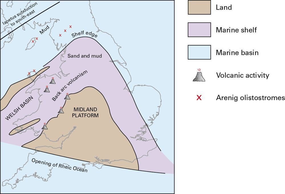
| 10:37, 6 June 2014 | P785835.jpg (file) |  |
98 KB | Dbk | Palaeogeographical sketch map of England and Wales during early to mid Ordovician. | 1 |
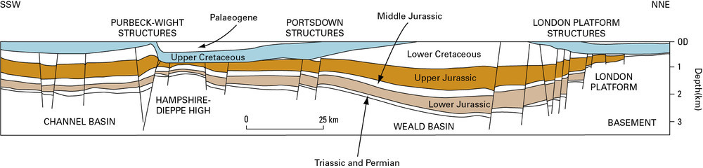
| 10:36, 6 June 2014 | P785829.jpg (file) | 63 KB | Dbk | Schematic cross-section of the Wessex Basin. | 1 | |
| 10:35, 6 June 2014 | P785825.jpg (file) |  |
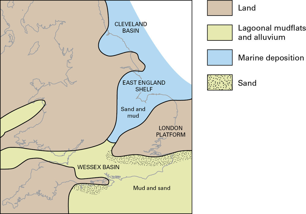
105 KB | Dbk | Early Cretaceous palaeogeographical sketch map. | 1 |
| 10:35, 6 June 2014 | P785822.jpg (file) |  |
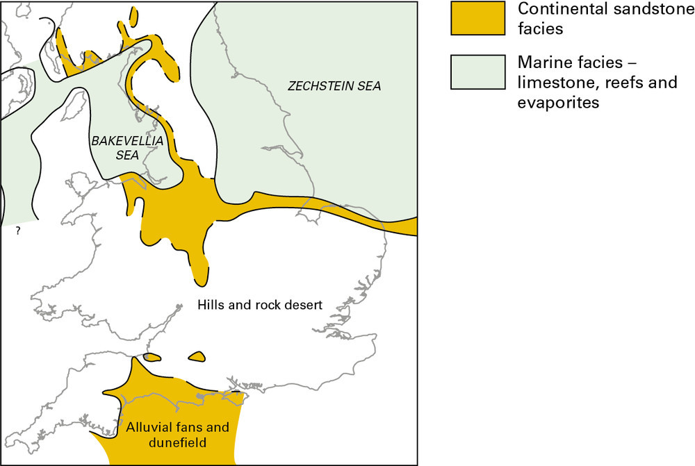
97 KB | Dbk | Late Permian palaeogeographical sketch map. | 1 |
| 10:08, 6 June 2014 | P785819.jpg (file) |  |
97 KB | Dbk | Carboniferous palaeogeographical sketch maps. b Early Namurian. | 1 |
| 10:07, 6 June 2014 | P785816.jpg (file) |  |
141 KB | Dbk | Click on a date/time to view the file as it appeared at that time. | 1 |
| 10:06, 6 June 2014 | P785812.jpg (file) |  |
78 KB | Dbk | Jurassic and Cretaceous 200 to 65 million years ago. | 1 |
| 10:03, 6 June 2014 | P785809.jpg (file) |  |
89 KB | Dbk | Mostly Devonian The Old Red Sandstone Supergroup 416 to 359 million years ago. | 1 |
| 10:02, 6 June 2014 | P785806.jpg (file) |  |
107 KB | Dbk | Mesoproterozoic and Neoproterozoic 1600 to 542 million years ago. | 1 |
| 10:01, 6 June 2014 | P785802.jpg (file) |  |
79 KB | Dbk | The lithological sequence in an idealised cyclothem. | 1 |
| 10:00, 6 June 2014 | P785796.jpg (file) |  |
119 KB | Dbk | Geological timescale. | 1 |
| 09:59, 6 June 2014 | P680255.jpg (file) |  |
150 KB | Dbk | 1 | |
| 09:58, 6 June 2014 | P669504.jpg (file) |  |
208 KB | Dbk | 1 | |
| 09:57, 6 June 2014 | P667873.jpg (file) |  |
217 KB | Dbk | 1 | |
| 09:56, 6 June 2014 | P667863.jpg (file) |  |
121 KB | Dbk | 1 | |
| 09:56, 6 June 2014 | P667860.jpg (file) |  |
150 KB | Dbk | 1 | |
| 09:54, 6 June 2014 | P667856.jpg (file) |  |
103 KB | Dbk | 1 | |
| 09:53, 6 June 2014 | P649399.jpg (file) |  |
145 KB | Dbk | 1 | |
| 09:52, 6 June 2014 | P616087.jpg (file) |  |
487 KB | Dbk | Typical texture of the Lewisian Gneiss Complex as seen in a quarry on the north side of Vatersay Causeway, Barra, Outer Hebrides. | 1 |
| 09:51, 6 June 2014 | P580468.jpg (file) |  |
267 KB | Dbk | Maculloch's Tree (cast of) encased in columnar basalt. Ardmeanach, Mull. Scale: hammer shaft is 30 cm. | 1 |
| 09:50, 6 June 2014 | P556198.jpg (file) |  |
127 KB | Dbk | View to north from disused sandstone quarries on the slopes of Towns Fell, above Gawthorp in Dentdale. Sandstone of Brigantian age Alston Formation. | 1 |
| 09:49, 6 June 2014 | P548172.jpg (file) |  |
203 KB | Dbk | 1 | |
| 09:48, 6 June 2014 | P547034.jpg (file) |  |
293 KB | Dbk | Dessication polygons in sandstone, Lybster Subgroup, Lower Caithness Flagstone Group. | 1 |
| 17:17, 5 June 2014 | P225483.jpg (file) |  |
264 KB | Dbk | Magheramorne Quarry. Ulster White Limestone. Well-bedded hard white chalk with flint bands and erosion surfaces outlined by orange-brown clay. | 1 |
| 17:16, 5 June 2014 | P225292.jpg (file) |  |
297 KB | Dbk | Knockmore Cliff, County Fermanagh. Looking SW. Knockmore Cliff. Scarp and scree in massive limestone, probably Upper Limestone, Carboniferous Limestone Series. | 1 |
| 17:14, 5 June 2014 | P222619.jpg (file) |  |
213 KB | Dbk | 50 m W. of Grimbald Crag, Knaresborough. Looking SE. The Carboniferous/Permian unconformity at Grimbald Crag, Knaresborough. Oolitic limestones of the Lower Magnesian Limestone - Upper Subdivision rest unconformably upon a buried hill of slightly redde... | 1 |
| 17:14, 5 June 2014 | P221294.jpg (file) |  |
278 KB | Dbk | Blackhall Rocks. Looking N. Eastern tip of headland, showing algal stromatolitic ?Hartlepool and Roker Dolomite with conspicuous bed of coarse rolled stromatolite blocks. | 1 |
| 17:13, 5 June 2014 | P220190.jpg (file) |  |
506 KB | Dbk | Dobb's Linn. Large groove cast on base of greywacke bed. The main waterfall flows down the slightly overturned base of a thick greywacke bed. The large groove casts are seen to the right of the waterfall. | 1 |
| 17:12, 5 June 2014 | P219662.jpg (file) |  |
329 KB | Dbk | N. of Loch Quoich, Kinloch Hourn Road and NE of Loch a' Choire Bheithe. Glenfinnan Group. Folded striped psammite and pelite typical of the Glenfinnan Group. Axial fabrics can be seen in pelite beside the hammer. | 1 |
| 16:42, 5 June 2014 | P895014.jpg (file) |  |
172 KB | Dbk | The development of the terminology in the offshore UK Sector. | 1 |
| 16:41, 5 June 2014 | P895010.jpg (file) |  |
176 KB | Dbk | The Inner Hebrides Scottish Chalk Province. | 1 |