File list
Jump to navigation
Jump to search
This special page shows all uploaded files.
| Date | Name | Thumbnail | Size | User | Description | Versions |
|---|---|---|---|---|---|---|
| 08:57, 9 October 2014 | P209845.jpg (file) |  |
788 KB | Dbk | Betchworth Hills, near Dorking. Looking NNE. North Downs escarpment with large Chalk quarries. The view is from a gravel flat on Lower Greensand across the Gault and Upper Greensand of the Vale of Holmsdale. The hillside rises steeply at about the junc... | 1 |
| 08:56, 9 October 2014 | P535262.jpg (file) |  |
332 KB | Dbk | Excavations in the Seaford Chalk and Lambeth Group during the construction of the M4 underpass at the A34/M4 junction, Chieveley, Oxfordshire. | 1 |
| 08:55, 9 October 2014 | P902250.jpg (file) | 35 KB | Dbk | Schematic cross-sections of the geology underlying London and the Thames Valley. | 1 | |
| 08:55, 9 October 2014 | P902271.jpg (file) | 39 KB | Dbk | Schematic cross-section of the geology underlying London and the Thames Valley. | 1 | |
| 08:53, 9 October 2014 | P902272.jpg (file) |  |
149 KB | Dbk | Geological sketch map showing the range and distribution of different rock types in the London and Thames Valley region, in relation to major towns and cities. The extent of London and Thames Valley region is identified on the inset map of the United K... | 1 |
| 07:40, 9 October 2014 | P210913.jpg (file) |  |
469 KB | Dbk | Whitlingham pit (E. side). Looking E. A 'paramoudra'. Such vertical flint masses may extend for several feet in the chalk of this region. They commonly have a hole passing through the centre and for this reason are sometimes called 'pot flints'. They m... | 1 |
| 07:38, 9 October 2014 | P902253.jpg (file) |  |
30 KB | Dbk | Schematic cross-section the underlying geology of part of East Anglia and the adjoining areas. | 1 |
| 07:38, 9 October 2014 | P902252.jpg (file) | 30 KB | Dbk | Schematic cross-section of the underlying geology of part of East Anglia and the adjoining areas. | 1 | |
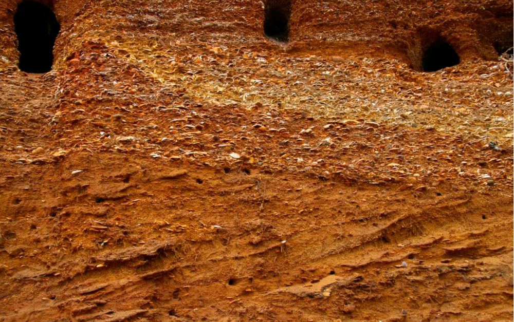
| 07:37, 9 October 2014 | P902286.jpg (file) |  |
322 KB | Dbk | The Crag, a soft shelly sand deposit that forms an important shallow aquifer in eastern Norfolk and Suffolk. | 1 |
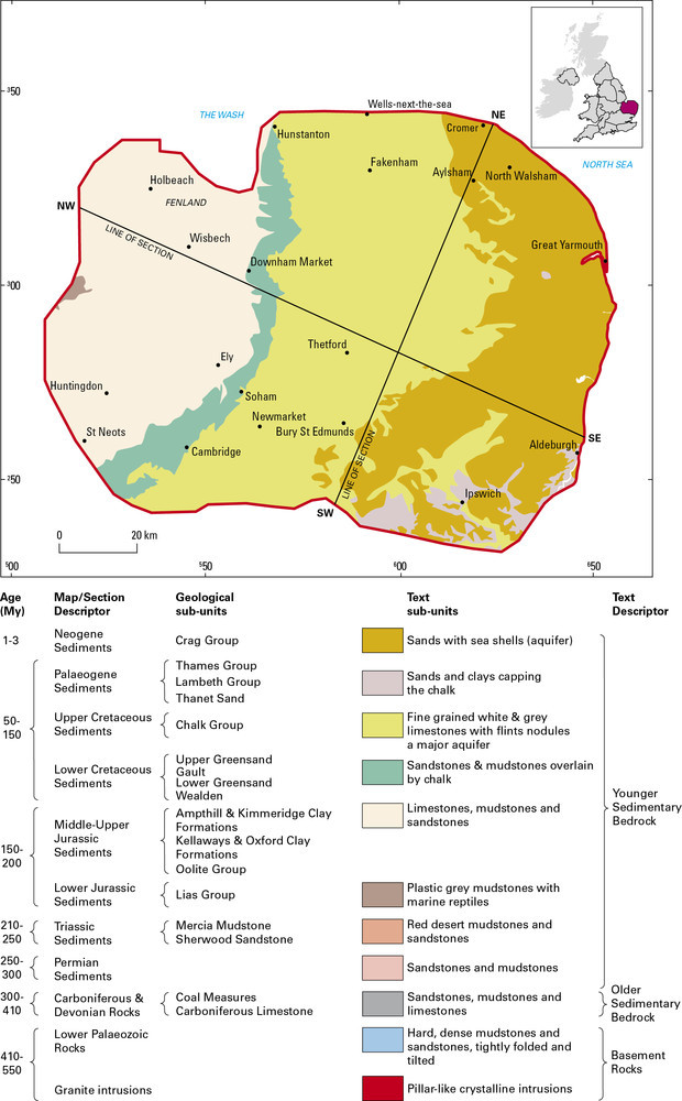
| 07:36, 9 October 2014 | P902251.jpg (file) |  |
147 KB | Dbk | Geological map and key showing the range and distribution of different bedrock types in East Anglia and adjoining areas. | 1 |
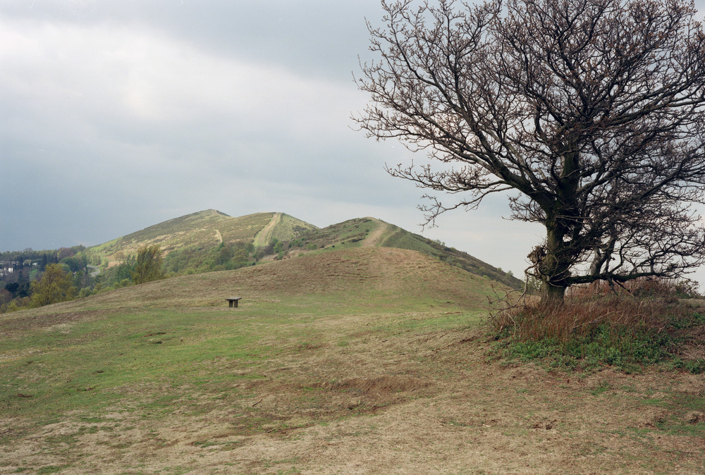
| 15:25, 8 October 2014 | P213697.jpg (file) |  |
286 KB | Dbk | The Malvern Hills, looking north from near Wynds Point, comprising hard igneous rocks of the Malvern Complex. | 1 |
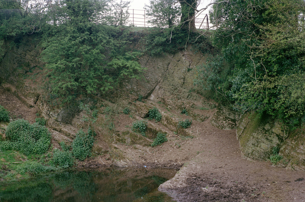
| 15:24, 8 October 2014 | P212676.jpg (file) |  |
345 KB | Dbk | Basement limestone and muddy limestone outcrop northeast of Ledbury. | 1 |
| 15:23, 8 October 2014 | P902281.jpg (file) | 21 KB | Dbk | Schematic cross-section of the geology of the Welsh Borderland. | 1 | |
| 15:22, 8 October 2014 | P902280.jpg (file) |  |
132 KB | Dbk | Geological map showing the range and distribution of different rock types in The Welsh Borderland, in relation to major towns and cities. | 1 |
| 14:59, 8 October 2014 | P731892.jpg (file) |  |
254 KB | Dbk | Jurassic limestone in the railway cutting at Roade, near Northampton. | 1 |
| 14:58, 8 October 2014 | P581676.jpg (file) |  |
137 KB | Dbk | Precambrian volcanic tuffs on Beacon Hill, Charnwood Forest. | 1 |
| 14:57, 8 October 2014 | P542174.jpg (file) |  |
225 KB | Dbk | View of Breedon on the Hill church and quarry, Northwest Leicestershire, in Carboniferous limestones. | 1 |
| 14:57, 8 October 2014 | P211735.jpg (file) |  |
286 KB | Dbk | Crawstone Ironstone Mine, Ironbridge, Shropshire, at the base of the Coal Measures. | 1 |
| 14:56, 8 October 2014 | P581675.jpg (file) |  |
140 KB | Dbk | Red mudstones (Mercia Mudstone) resting on a marked erosion surface (unconformity) on a much older Ordovician igneous intrusion, Croft Quarry, Leicestershire. | 1 |
| 14:56, 8 October 2014 | P222787.jpg (file) |  |
187 KB | Dbk | Beeston Castle Grotto in Sherwood Sandstone, southeast of Chester. | 1 |
| 14:54, 8 October 2014 | P902249.jpg (file) |  |
46 KB | Dbk | Schematic cross-section of the geology of the Central England region from west to east. | 1 |
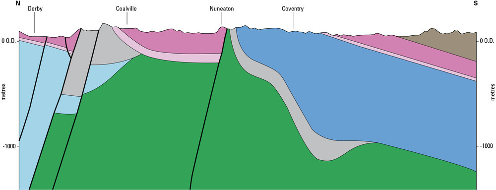
| 14:54, 8 October 2014 | P902248.jpg (file) |  |
50 KB | Dbk | Schematic cross-section of the geology of the Central England region from north to south. | 1 |
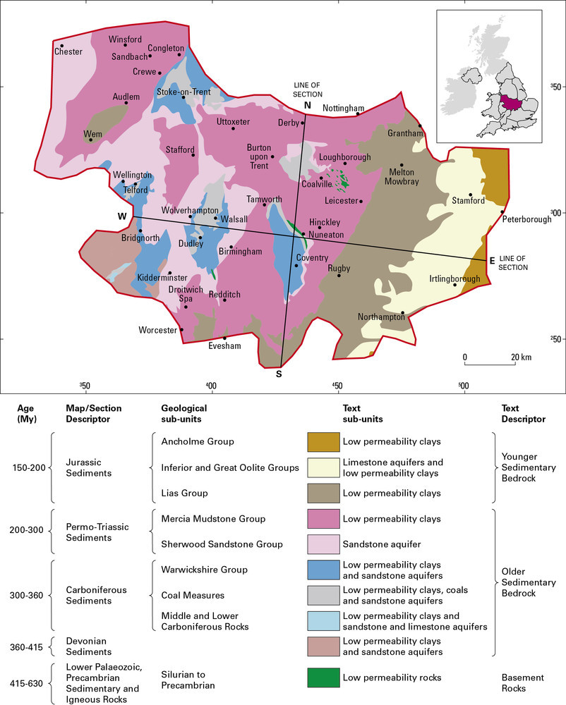
| 14:53, 8 October 2014 | P902247.jpg (file) |  |
178 KB | Dbk | Topographic sketch map of The Central England region showing major towns and cities. The region is identified on the inset map of the United Kingdom. | 1 |
| 15:10, 7 October 2014 | P902256.jpg (file) |  |
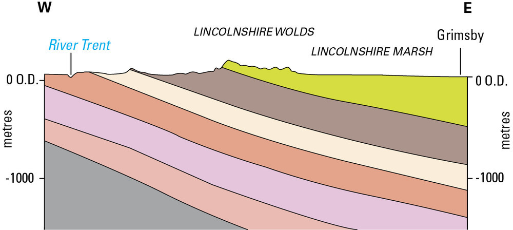
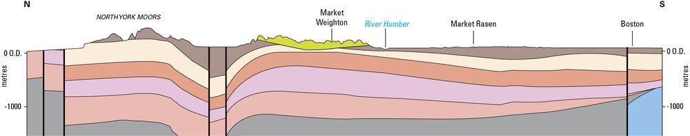
62 KB | Dbk | Schematic cross-section through Eastern England | 1 |
| 15:10, 7 October 2014 | P902255.jpg (file) | 40 KB | Dbk | Schematic cross-section through Eastern England | 1 | |
| 15:03, 7 October 2014 | P902254.jpg (file) |  |
134 KB | Dbk | Geological map and key showing the range and distribution of different rock types in the Eastern England region, in relation to major towns and cities. The extent of the Eastern England region is defined on the inset map of the United Kingdom. | 1 |
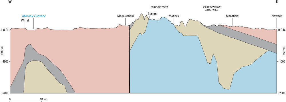
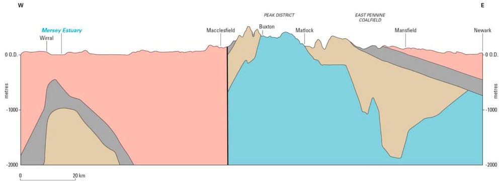
| 14:50, 7 October 2014 | P902267.jpg (file) |  |
41 KB | Dbk | Schematic cross-section of the geology of The Pennines and adjacent areas from the Wirral to Nottinghamshire | 1 |
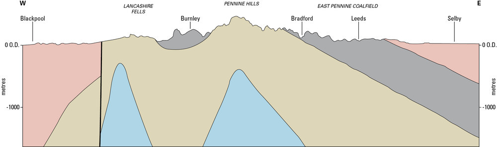
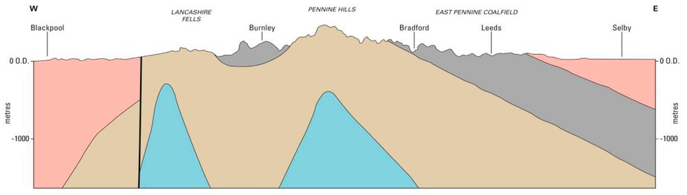
| 14:50, 7 October 2014 | P902266.jpg (file) |  |
34 KB | Dbk | Schematic cross-section of the geology of The Pennines and adjacent areas from The Fylde to North Yorkshire | 1 |
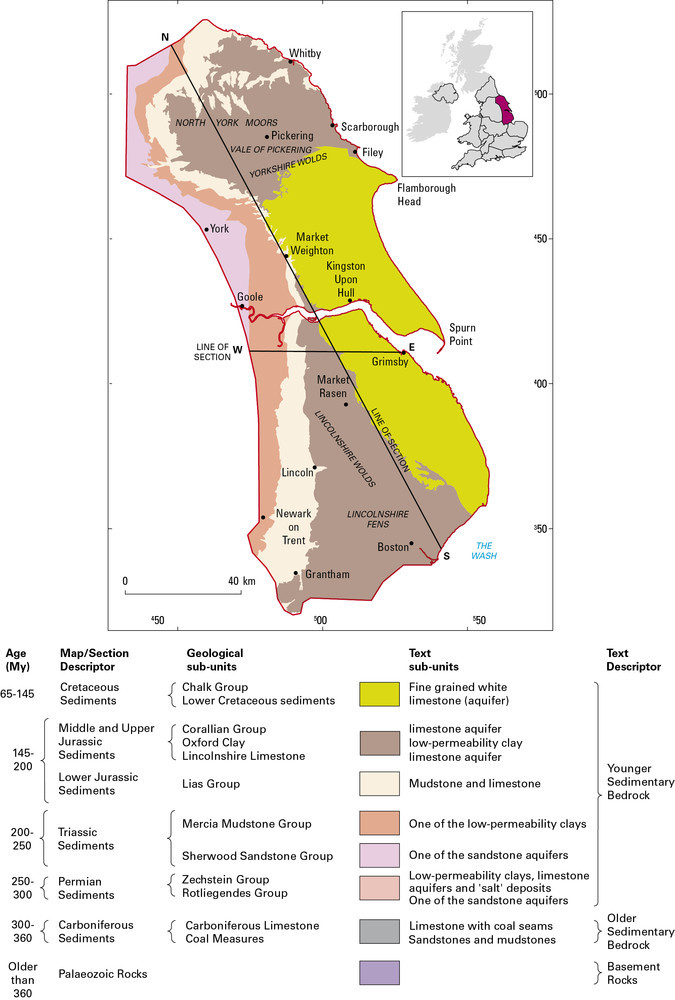
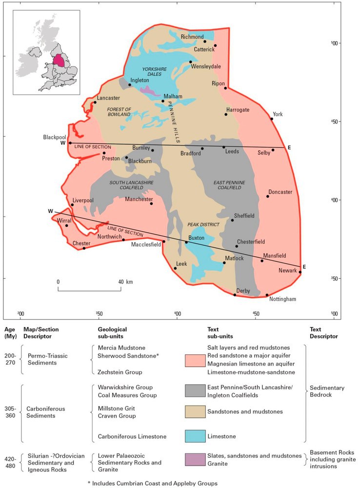
| 14:47, 7 October 2014 | P902265.jpg (file) |  |
143 KB | Dbk | Geological sketch map showing the range and distribution of different rock types in The Pennines and adjacent areas | 1 |
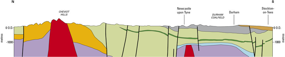
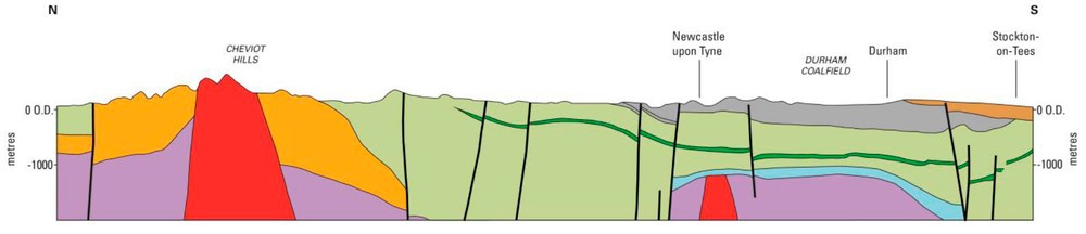
| 14:44, 7 October 2014 | P902282.jpg (file) | 39 KB | Dbk | Schematic cross-section of the geology of Northern England extending from the Cheviot Hills to County Durham | 1 | |
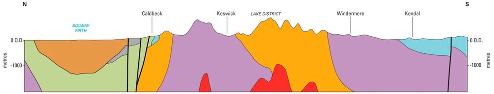
| 14:43, 7 October 2014 | P902259.jpg (file) | 32 KB | Dbk | Schematic cross-section of the geology of Northern England extending from the Solway Firth to north Lancashire | 1 | |
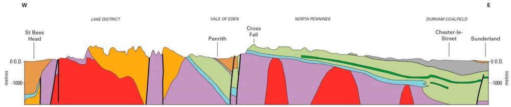
| 14:42, 7 October 2014 | P902261.jpg (file) | 43 KB | Dbk | Schematic cross-section of the geology of Northern England extending from the Irish Sea to North Sea | 1 | |
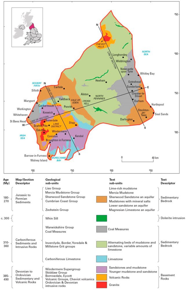
| 13:55, 7 October 2014 | P902262.jpg (file) |  |
137 KB | Dbk | Geological map showing the range and distribution of different rock types in Northern England. The extent of Northern England region is identified on the inset map of the United Kingdom | 1 |
| 13:57, 3 October 2014 | P595813.jpg (file) |  |
98 KB | Dbk | Typical landscape of the Yorkshire Wolds with rolling hills and deep valleys underlain by the Chalk. | 1 |
| 13:52, 3 October 2014 | P213703.jpg (file) |  |
204 KB | Dbk | The Lincolnshire Limestone, quarried near to Sleaford. | 1 |
| 13:50, 3 October 2014 | P708326.jpg (file) |  |
176 KB | Dbk | The Triassic Mercia Mudstone close to Newark contains seams of gypsum, a mineral that is quarried and used in the production of plaster. | 1 |
| 13:46, 3 October 2014 | P9202244.jpg (file) |  |
891 KB | Dbk | The distinctive landscape of the North York Moors with hard sedimentary bedrock layers capping the higher ground, and softer mudstones and other sediments forming the valley sides. | 1 |
| 16:21, 2 October 2014 | P774911.jpg (file) |  |
303 KB | Dbk | The Hard Bed Coal (0.8 m thick), seen in the left of the photo, is underlain by a pale grey ganister and seatclay palaeosol. The Stanningley Rock (2.8 m seen) is exposed at the top of the section, about 30 m above the Hard Bed Coal. | 1 |
| 16:20, 2 October 2014 | P596266.jpg (file) |  |
125 KB | Dbk | Scrooby Top Quarry. Rotheram Sand & Gravel Co. Ltd. About 11 km north-west of Worksop. A sand and gravel quarry over Triassic, Sherwood Sandstone Group. It is worked for building sand, concrete aggregate and decorative aggregate. | 1 |
| 16:19, 2 October 2014 | P223240.jpg (file) |  |
240 KB | Dbk | Sharow, near Ripon. Looking N. Subsidence hollow formed on February 1st 1982 after the dissolution of Permian gypsum. This hollow was initially about 11 m. in diameter and up to 9 m. deep. | 1 |
| 16:19, 2 October 2014 | P006206.jpg (file) |  |
167 KB | Dbk | Mam Tor. Looking W. Landslip-scar in Mam Tor Beds, with alternating sandstones and mudstones. | 1 |
| 16:18, 2 October 2014 | P005589.jpg (file) |  |
210 KB | Dbk | Gordale Scar, near Malham. Malham Formation. Gorge through Malham Formation limestones. The Cove Limestone (Holkerian) forms the lower massive bedded crags; the contract with the overlying Gordale Limestone (Asbian) is the prominent bedding plane visib... | 1 |
| 16:17, 2 October 2014 | P902243.jpg (file) |  |
34 KB | Dbk | Schematic cross-section of the geology of The Pennines and adjacent areas from the Wirral to Nottinghamshire. | 1 |
| 16:17, 2 October 2014 | P902242.jpg (file) |  |
29 KB | Dbk | Schematic cross-section of the geology of The Pennines and adjacent areas from The Fylde to North Yorkshire. | 1 |
| 16:16, 2 October 2014 | P902241.jpg (file) |  |
117 KB | Dbk | Geological sketch map showing the range and distribution of different rock types in The Pennines and adjacent areas. The extent of the region is identified on the inset map of the United Kingdom. | 1 |
| 15:56, 2 October 2014 | P902240.jpg (file) |  |
279 KB | Dbk | Sherwood Sandstone at Ousby in the Vale of Eden, Cumbria. | 1 |
| 15:55, 2 October 2014 | P902239.jpg (file) | 32 KB | Dbk | Schematic cross-section of the geology of Northern England extending from the Cheviot Hills to County Durham. | 1 | |
| 15:55, 2 October 2014 | P902238.jpg (file) | 25 KB | Dbk | Schematic cross-section of the geology of Northern England extending from the Solway Firth to north Lancashire. | 1 | |
| 15:54, 2 October 2014 | P902237.jpg (file) | 33 KB | Dbk | Schematic cross-section of the geology of Northern England extending from the Irish Sea to North Sea. | 1 | |
| 15:54, 2 October 2014 | P902236.jpg (file) |  |
114 KB | Dbk | Geological map showing the range and distribution of different rock types in Northern England. The extent of Northern England region is identified on the inset map of the United Kingdom. | 1 |