File list
Jump to navigation
Jump to search
This special page shows all uploaded files.
| Date | Name | Thumbnail | Size | User | Description | Versions |
|---|---|---|---|---|---|---|
| 20:24, 7 February 2015 | Water of Leith Valley.png (file) |  |
71 KB | Scotfot | Water of Leith Valley. Map from Lothian geology: an excursion guide. Edinburgh : Edinburgh Geological Society, 1986. | 1 |
| 19:41, 7 February 2015 | P001324.jpg (file) |  |
253 KB | Scotfot | Oblique aerial view of Calton Hill and the Arthur's Seat volcano, looking from the north-west. | 1 |
| 13:00, 30 January 2015 | P239116.jpg (file) |  |
1.07 MB | Dbk | Exposed during excavation in 1901, mudstone beds of the Cotham Formation are overlain by the prominent limestone of the White Lias Formation, succeeded by interbedded mudstone and limestone of the basal part of the Blue Lias Formation. Approximate loca... | 1 |
| 15:29, 10 October 2014 | P902263.jpg (file) | 35 KB | Dbk | Schematic cross-section through the geology of Northern Ireland. | 1 | |
| 15:27, 10 October 2014 | P902264.jpg (file) |  |
169 KB | Dbk | Geological sketch map showing the range and distribution of different rock types in Northern Ireland, in relation to the major towns and cities. The extent of the Northern Ireland region is shown on the inset map of the United Kingdom. | 1 |
| 15:24, 10 October 2014 | P662435.jpg (file) |  |
178 KB | Dbk | Alternating limestones and shales of Porthkerry Formation (Jurassic). Dunraven. | 1 |
| 15:23, 10 October 2014 | P662426.jpg (file) |  |
148 KB | Dbk | Carboniferous limestone outcrop along the escarpment of Mynydd Eglwysseg, Llangollen. | 1 |
| 15:22, 10 October 2014 | P210903.jpg (file) |  |
176 KB | Dbk | Brecon Beacons. Looking E. Brecon Beacons. North face of Pen y Fan. | 1 |
| 15:21, 10 October 2014 | P006965.jpg (file) |  |
207 KB | Dbk | Crib Goch ridge. Looking WSW. Bedding and cleavage planes prominent in Ordovician volcanics. Crib Goch ridge with 'pinnacles'. Snowdon left background, Crib Y Ddysgl right background. | 1 |
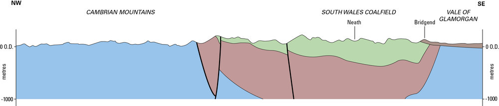
| 15:19, 10 October 2014 | P902275.jpg (file) | 28 KB | Dbk | Schematic cross-section of the geology of South Wales. | 1 | |
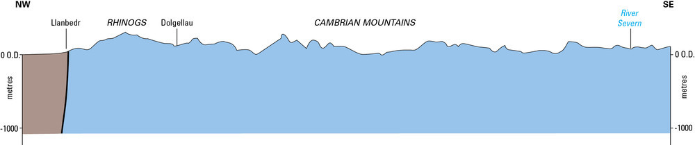
| 15:19, 10 October 2014 | P902273.jpg (file) | 22 KB | Dbk | Schematic cross-section of the geology of Central Wales. | 1 | |
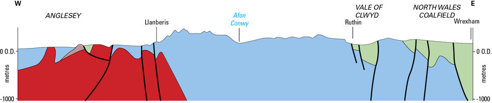
| 15:18, 10 October 2014 | P902276.jpg (file) | 37 KB | Dbk | Schematic cross-section of the geology of Anglesey and Northwest Wales. | 1 | |
| 15:17, 10 October 2014 | P902274.jpg (file) |  |
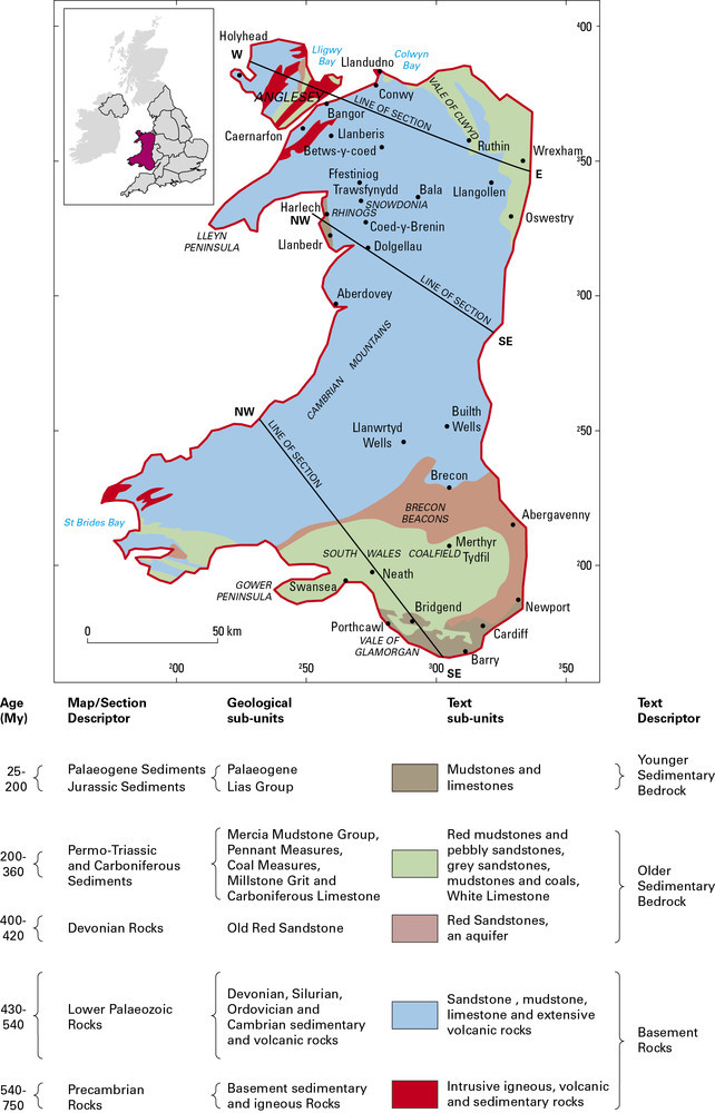
148 KB | Dbk | Geological map showing the range and distribution of different rock types in Wales, in relation to the topography and major towns and cities. Wales is identified on the inset map of the United Kingdom. | 1 |
| 14:00, 10 October 2014 | P902268.jpg (file) |  |
165 KB | Dbk | Geological sketch map showing the range and distribution of different rock types in the South West England Region, in relation to the major towns and cities. The extent of the region is shown on the inset map of the United Kingdom. | 1 |
| 13:59, 10 October 2014 | P902610.jpg (file) |  |
235 KB | Dbk | Highly deformed metamorphic rock of the Start Point Complex. | 1 |
| 13:58, 10 October 2014 | P209965.jpg (file) |  |
173 KB | Dbk | A Dartmoor granite tor, Blackingstone Rock, Devon. Blackingstone Rock, a Dartmoor granite tor. Looking east-south-east. A granite tor on the northern margins of the Dartmoor granite. The coarse porphyritic granite is cut by steep joints and also by the... | 1 |
| 13:57, 10 October 2014 | P212763.jpg (file) |  |
158 KB | Dbk | Wild Pear Beach. Overfolds in Wild Pear Slates (Ilfracombe Slates). Close to the major fault which separates Hangman Grits from Ilfracombe Slates the Wild Pear Slates are overfolded. The north-facing, fairly tight overfolds are strongly cleaved in thei... | 1 |
| 13:56, 10 October 2014 | P211236.jpg (file) |  |
168 KB | Dbk | Warren Beach, Hartland Quay. Looking NE. Coastal structure. Upright chevron folds in sandstones, siltstones and shales of the Crackington Formation. | 1 |
| 13:55, 10 October 2014 | P211134.jpg (file) |  |
159 KB | Dbk | View from Easton Barton, Lapford. Looking E. Topography on Carboniferous Rocks. Typical well-rounded sandstone features in the Bude Formation; the low-lying area behind the buildings is underlain by silty shales. Formerly, the sandstones were extensive... | 1 |
| 13:53, 10 October 2014 | P781352.jpg (file) |  |
242 KB | Dbk | The Budleigh Salterton Pebble Beds at Town Farm Pit, near Burlscombe. Height of face about 5 m. | 1 |
| 13:48, 10 October 2014 | P211333.jpg (file) |  |
179 KB | Dbk | Watchet. Looking SE. Gypsiferous Keuper Marl. In the foreground gypsiferous Keuper Marl is visible. Arietites bucklandi Zone beds of the Lias are present in the higher cliffs and are faulted into contact with the red 'marls'. Scree of Lias debris obscu... | 1 |
| 13:43, 10 October 2014 | P902269.jpg (file) |  |
32 KB | Dbk | Schematic cross-section of the underlying geology of the Southwest region from Exmoor to Start Point. | 1 |
| 13:42, 10 October 2014 | P902270.jpg (file) |  |
44 KB | Dbk | Schematic cross-section of the geology of the Southwest region from St Just to Crewkerne. | 1 |
| 10:39, 10 October 2014 | P902609.jpg (file) |  |
212 KB | Dbk | The De la Beche Unconformity. Horizontally bedded Jurassic limestones (Inferior Oolite) rest upon grey folded Carboniferous Limestone, Vallis Vale, near Frome. | 1 |
| 10:39, 10 October 2014 | P902608.jpg (file) |  |
348 KB | Dbk | Oolitic limestones of the Inferior Oolite Group exposed on Leckhampton Hill, near Cheltenham. | 1 |
| 10:38, 10 October 2014 | P902607.jpg (file) |  |
268 KB | Dbk | Seacliffs on the north Somerset coast near Watchet. Here the red –brown Mercia Mudstone is faulted against the paler Jurassic rocks of the Lias. | 1 |
| 10:37, 10 October 2014 | P006946.jpg (file) |  |
245 KB | Dbk | Rock of Ages, Burrington Combe. Looking E. Burrington Combe. Steeply-dipping Burrington Oolite (Carboniferous Limestone). An inscription can be seen about 20 ft. above road level to the left of the prominent cleft, recording that this inspired the Rev.... | 1 |
| 10:36, 10 October 2014 | P006732.jpg (file) |  |
200 KB | Dbk | Avon Gorge at Hotwells. Looking E. Avon Gorge Series. Hotwells Limestone at the Hotwells. The base of the Hotwells Limestone is seen on the left-hand side at the foot of the Zig Zag path. The large white building on the cliff top is the Grand Spa Hotel... | 1 |
| 10:33, 10 October 2014 | P211058.jpg (file) |  |
145 KB | Dbk | Aust Cliff. Aust Cliff. Aust Cliff seen from the Severn Bridge looking north. The cliff of red Keuper Marl is capped by Tea-Green Marl and Rhaetic. | 1 |
| 10:04, 10 October 2014 | P902246.jpg (file) | 37 KB | Dbk | Geological sketch map and key showing the range and distribution of different rock types in the Bristol and Gloucester region, in relation to the major towns and cities. The extent of the Bristol and Gloucester region is identified on the inset map of ... | 1 | |
| 10:02, 10 October 2014 | P902245.jpg (file) |  |
132 KB | Dbk | Geological sketch map and key showing the range and distribution of different rock types in the Bristol and Gloucester region, in relation to the major towns and cities. The extent of the Bristol and Gloucester region is identified on the inset map of ... | 1 |
| 09:11, 10 October 2014 | P579296.jpg (file) |  |
498 KB | Dbk | View of cliffs east of Sidmouth, south Devon, looking west towards the town. Shows the gradational upward passage by interdigitation from the Otter Sandstone Formation (Triassic, Sherwood Sandstone Group) in the lower half of the cliff to the overlying... | 1 |
| 09:10, 10 October 2014 | P774554.jpg (file) |  |
115 KB | Dbk | Coastal section Whale Chine to Blackgang, Cliff top Isle of Wight. Chale Bay Panorama - east from the cliffs where the Atherfield Clay comes to crop towards the Blackgang bluff and Rocken End. | 1 |
| 09:09, 10 October 2014 | P005800.jpg (file) |  |
666 KB | Dbk | Stair Hole Cove, West Lulworth. Looking ESE. Marine erosion at Stair Hole Cove. On the right at the foot of the cliff Portland Stone and the massive Lower Purbeck Limestone have been breached by the sea which is making a cove in the softer Middle Purbe... | 1 |
| 09:08, 10 October 2014 | P700021.jpg (file) |  |
139 KB | Dbk | The Needles composed of steeply inclined Chalk seen from Scratchell’s Bay. | 1 |
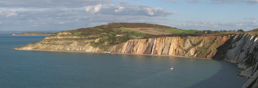
| 09:01, 10 October 2014 | P902434.jpg (file) |  |
87 KB | Dbk | A general view of the Palaeogene sediments at Alum Bay on the Isle of Wight, looking east from the Needles. | 1 |
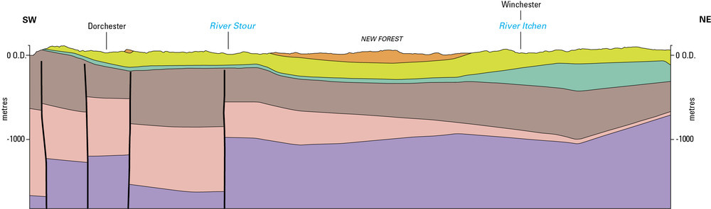
| 08:59, 10 October 2014 | P902260.jpg (file) |  |
42 KB | Dbk | Schematic cross-section of the underlying geology from Lyme Bay in Dorset through the New Forest and on to NE Hampshire. | 1 |
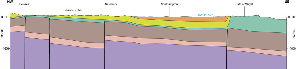
| 08:59, 10 October 2014 | P902258.jpg (file) | 36 KB | Dbk | Schematic cross-section of the underlying geology from the Vale of Pewsey in NW Wiltshire toward the Isle of Wight. | 1 | |
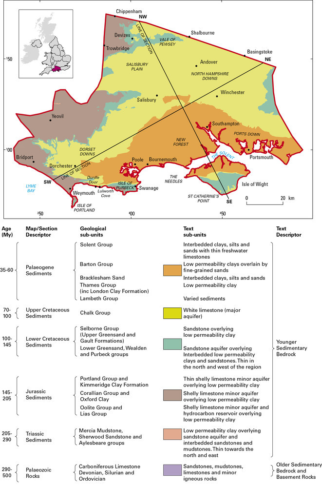
| 08:58, 10 October 2014 | P902257.jpg (file) |  |
175 KB | Dbk | Geological sketch map and key showing the range and distribution of different rock types in the Hampshire Basin, in relation to the major towns and cities. The extent of the region is identified on the inset map of the United Kingdom. | 1 |
| 08:54, 10 October 2014 | P902530.jpg (file) |  |
112 KB | Dbk | The extent of the London Platform. | 1 |
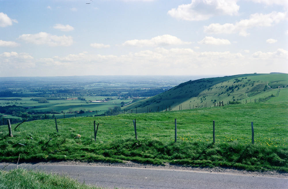
| 09:41, 9 October 2014 | P212516.jpg (file) |  |
241 KB | Dbk | Dichling Beacon. Central Weald from Ditchling Beacon. View to north-east from near summit of Ditchling Beacon across central Weald. | 1 |
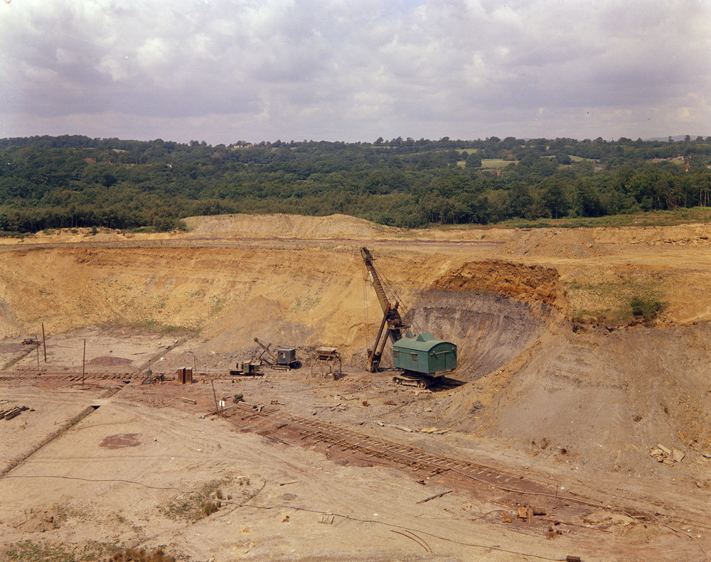
| 09:40, 9 October 2014 | P209934.jpg (file) |  |
314 KB | Dbk | Brickworks clay-pit, Warnham Brickworks, Horsham, Sussex. Looking north-west at Warnham Brickworks clay-pit, 2 1/2 m. north of Horsham. A view of the north face of the pit showing the main working face in 1963. The section being excavated by the mechan... | 1 |
| 09:39, 9 October 2014 | P209590.jpg (file) |  |
435 KB | Dbk | 400 yd. N. of crossroads at Aldington Corner. Looking N. Section in Hythe Beds. Beds of ragstone separated by hassock. Some of the ragstone tends to be nodular. There is disintegration of the beds below the soil. | 1 |
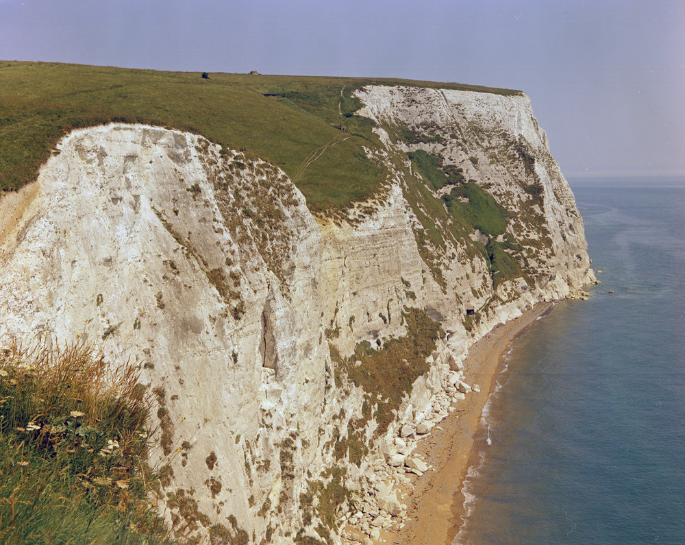
| 09:38, 9 October 2014 | P209962.jpg (file) |  |
359 KB | Dbk | Langdon Bay, 1 1/2 m. E. of Dover. Looking ENE. Chalk cliffs at Langdon Bay. The chalk at the base of the cliffs is in the Terebratulina lata Zone, the Middle Chalk - Upper Chalk boundary being near the top of the pill-box at the bottom of the Langdon ... | 1 |
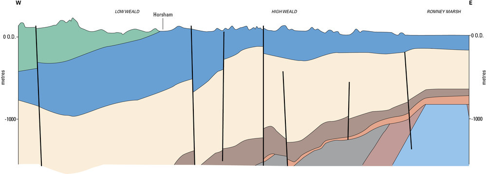
| 09:36, 9 October 2014 | P902278.jpg (file) |  |
47 KB | Dbk | Schematic through the Wealden region from west to east. | 1 |
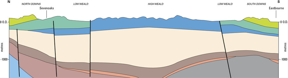
| 09:35, 9 October 2014 | P902279.jpg (file) | 43 KB | Dbk | Schematic cross-section through the Wealden region from north to south. | 1 | |
| 09:35, 9 October 2014 | P209919.jpg (file) |  |
296 KB | Dbk | A natural outcrop of Lower Tunbridge Wells Sand. Stone Farm Rocks. Looking east, Sussex. The Lower Tunbridge Wells Sand is a massive, clean, white quartzitic sandstone containing lenses and stringers of small pebbles, mainly vein quartz. It is a finely... | 1 |
| 09:33, 9 October 2014 | P902277.jpg (file) |  |
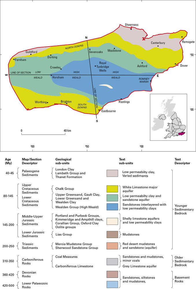
136 KB | Dbk | Geological sketch map and key showing the range and distribution of different rock types in the Wealden District in relation to major towns and cities. | 1 |
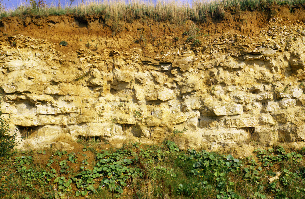
| 09:02, 9 October 2014 | P211894.jpg (file) |  |
944 KB | Dbk | Section in White Limestone, Breakspear's Pit, North Leigh, Oxfordshire. Looking east at Breakspear's Pit, North Leigh. Quarry for aggregate; detailed sequence as follows: Oolite - cream to pale brown, medium to fine-grained, shelly, shell detrital, cro... | 1 |
| 08:59, 9 October 2014 | P902287.jpg (file) |  |
216 KB | Dbk | Water-filled fissures and pores dissolved in the Chalk, seen in a borehole, Height of image about 50 cm. | 1 |