User contributions for Scotfot
Jump to navigation
Jump to search
3 November 2015
- 23:2923:29, 3 November 2015 diff hist +1,036 N File:EGS Ballachulish Photo 21.jpg User created page with UploadWizard current
- 23:2923:29, 3 November 2015 diff hist +901 N File:EGS Ballachulish Photo 20.jpg User created page with UploadWizard current
- 23:2923:29, 3 November 2015 diff hist +661 N File:EGS Ballachulish Photo 18.jpg User created page with UploadWizard current
- 23:2923:29, 3 November 2015 diff hist +973 N File:EGS Ballachulish Photo 17.jpg User created page with UploadWizard current
- 23:2923:29, 3 November 2015 diff hist +735 N File:EGS Ballachulish Photo 19.jpg User created page with UploadWizard current
- 23:2423:24, 3 November 2015 diff hist +1,009 N File:EGS Ballachulish Photo 15.jpg View of the contact between granite of the igneous complex (light coloured upper crags) and the Chaotic Zone pelitic migmatites (dark lower exposures. Photo 15. From: Pattison, D.R.M. and Harte, B. The Ballachulish Igneous Complex and aureole: a field... current
- 23:1923:19, 3 November 2015 diff hist +776 N File:EGS Ballachulish Photo 13.jpg User created page with UploadWizard current
- 23:1923:19, 3 November 2015 diff hist +678 N File:EGS Ballachulish Photo 16.jpg User created page with UploadWizard current
- 23:1923:19, 3 November 2015 diff hist +766 N File:EGS Ballachulish Photo 14.jpg User created page with UploadWizard current
- 23:1123:11, 3 November 2015 diff hist +1,426 N File:EGS Ballachulish Photo 12.jpg Stops 3-4, 1-8, 5-2, 5-4 and 5-5. Massive Crd+Kfs-bearing pelitic hornfels characteristic of Zone IVb. The photograph was taken near Stop 5-5 in Coire Giubhsachain, but is representative of Zone IVb in many parts of the aureole. Note the mesh or honeyc... current
- 23:0923:09, 3 November 2015 diff hist +1,113 N File:EGS Ballachulish Photo 11.jpg Stop 3-3. Massive, pitted pelitic hornfels from the high grade end of Zone III. Fraochaidh transect. The pits represent the sites of weathered out cordierite crystals. The matrix surrounding the pits is rich in muscovite, biotite and quartz. Scale bar... current
- 23:0323:03, 3 November 2015 diff hist +1,028 N File:EGS Ballachulish Photo 10.jpg Stops 1-8 and 1-9. Incipient migmatitic features in interbedded pelitic and semipelitic hornfels, upper Zone V. See description of Stop 1-9 for an explanation of the features. Photo 10 From: Pattison, D.R.M. and Harte, B. The Ballachulish Igneous Comp... current
- 23:0223:02, 3 November 2015 diff hist +1,134 N File:EGS Ballachulish Photo 09.jpg Stops 1-8, 5-4 and 5-5. Interbedded psammite (light layers) and pelitic hornfels (dark, knobbly layers, rich in cordierite+K feldspar+andalusite), from Zone V. The actual exposure in the photograph is from near Stop 5-5, but is similar to exposures see... current
- 23:0023:00, 3 November 2015 diff hist +1,064 N File:EGS Ballachulish Photo 08.jpg Stop 1-7/1. Inclusion-rich quartz diorite. The inclusions range from metasedimentary, especially metapelitic, xenoliths, to intermediate-mafic igneous inclusions of similar mineralogy to the host quartz diorite. Photo 8. From: Pattison, D.R.M. and Har... current
- 22:5822:58, 3 November 2015 diff hist +1,295 N File:EGS Ballachulish Photo 07.jpg Stops 1-3 and 3-1. Cordierite porphyroblasts visible as dark patches on cleavage planes of regional phyllites and schists. Note that the size of the patches varies in different parts of the rock. This sample comes from roadside exposures near the parki... current
- 22:5522:55, 3 November 2015 diff hist +1,095 N File:EGS Ballachulish Photo 06.jpg Stop 1-2. Fine grained graphitic black slate/phyllite of the Ballachulish Slate lithology interbedded with dark grey marble of the Ballachulish Limestone lithology (foreground). These rocks lie immediately east of the Ballachulish Slide. Photo 6. From... current
- 22:5322:53, 3 November 2015 diff hist +972 N File:EGS Ballachulish Photo 05.jpg Stop 1-2. Garnetiferous phyllite/schist of the Leven Schist lithology, immediately west of the Ballachulish Slide. Photo 5. From: Pattison, D.R.M. and Harte, B. The Ballachulish Igneous Complex and aureole: a field guide. Edinburgh : Edinburgh Geologi... current
- 22:5122:51, 3 November 2015 diff hist +3,397 N File:EGS Ballachulish Photo 04.jpg View of the Beinn a' Bheithir massif underlain by the Ballachulish Igneous Complex and Aureole, taken looking south across Loch Leven from the Onich shore near Stop 1-1. The hill complex seen is referred to Collectively as Beinn Bheithir and the peaks... current
- 22:4722:47, 3 November 2015 diff hist +1,051 N File:EGS Ballachulish Photo 03.jpg View from Beinn Bhan looking NE over the town of Ballachulish and the abandoned East Laroch slate quarry to Loch Leven. On the left skyline is Ben Nevis, with the Mamores stretching to the east. Photo 3 from: Pattison, D.R.M. and Harte, B. The Ballach... current


2 November 2015
- 00:3300:33, 2 November 2015 diff hist +1,066 N File:EGS Ballachulish Photo 02.jpg View to SW from the summit of Sgorr Dhearg, with the summit of Sgorr Dhonuill on the right and looking across Loch Linnhe towards the mountains of Mull. The prominent island visible in Loch Linnhe is Lismore. Photo 3. From: Pattison, D.R.M. and Harte,...
- 00:0600:06, 2 November 2015 diff hist +1,263 N File:EGS Ballachulish Photo 01.jpg Overview of the Beinn a' Bheithir hill massif, fonned by the Ballachulish Igneous Complex and Aureole. The view is from the north-east (on Tom Meadhoin ridge), looking southwards across Loch Leven, with the Ballachulish Bridge on the right. The peak in...
- 00:0100:01, 2 November 2015 diff hist +35 File:EGS Ballachulish Fig 08A.jpg →Summary current


1 November 2015
- 23:5923:59, 1 November 2015 diff hist +988 N File:EGS Ballachulish Fig 13B.jpg Corresponding topographic map showing location of field stops for Day 5 (reproduced with permission by the Ordnance Survey). Figure 13B From: Pattison, D.R.M. and Harte, B. The Ballachulish Igneous Complex and aureole: a field guide. Edinburgh : E... current
- 23:5623:56, 1 November 2015 diff hist +995 N File:EGS Ballachulish Fig 13A.jpg Figure 13: (a) Geological map showing location of field stops for Day 5 (see Media:EGS Ballachulish Fig 07.jpg for key to geological map). From: Pattison, D.R.M. and Harte, B. The Ballachulish Igneous Complex and aureole: a field guide. Edinbu... current
- 23:5423:54, 1 November 2015 diff hist +988 N File:EGS Ballachulish Fig 12B.jpg Figure 12: (b) Corresponding topographic map showing location of field stops for Day 4 (reproduced with permission by the Ordnance Survey). From: Pattison, D.R.M. and Harte, B. The Ballachulish Igneous Complex and aureole: a field guide. Edinburgh : E... current
- 23:5323:53, 1 November 2015 diff hist +291 N File:EGS Ballachulish Fig 12A.jpg Geological map showing location of field stops for Day 4 (see Media:EGS Ballachulish Fig 07.jpg for key to geological map Figure 12: (a) From: Pattison, D.R.M. and Harte, B. The Ballachulish Igneous Complex and aureole: a field guide. Edinburg... current
- 23:5223:52, 1 November 2015 diff hist +996 N File:EGS Ballachulish Fig 11B.jpg Corresponding topographic map showing location of field stops for Day 3 Part 2: (reproduced with permission of the Ordnance Survey). Figure 11: (b) From: Pattison, D.R.M. and Harte, B. The Ballachulish Igneous Complex and aureole: a field guide. Edinb... current
- 23:5123:51, 1 November 2015 diff hist +1,043 N File:EGS Ballachulish Fig 11A.jpg Geological map showing location of field stops for Day 3 Part 2, (see Media:EGS Ballachulish Fig 07.jpg for key to geological map). Also shows Day 1, Stops 1-7 1-8 & 1-9. Figure 11: (a) From: Pattison, D.R.M. and Harte, B. The Ballachulish Ig... current
- 21:4921:49, 1 November 2015 diff hist +1,012 N File:EGS Ballachulish Fig 10B.jpg Corresponding topographic map showing location of field stops for Day 3, Part 1, Fraochaidh traverse. (reproduced with permission by the Ordnance Survey) Figure 10: (b) From: Pattison, D.R.M. and Harte, B. The Ballachulish Igneous Complex and aureole:... current
- 21:4821:48, 1 November 2015 diff hist +1,020 N File:EGS Ballachulish Fig 10A.jpg Geological map showing location of field stops for Day 3 Part 1, Fraochaidh traverse, (see Media:EGS Ballachulish Fig 07.jpg for key to geological map). Figure 10: (a) From: Pattison, D.R.M. and Harte, B. The Ballachulish Igneous Complex and aureo... current
- 21:4521:45, 1 November 2015 diff hist +989 N File:EGS Ballachulish Fig 09B.jpg Corresponding topographic map showing location of field stops for Day 2 (reproduced with permission of the Ordnance Survey). Figure 9: (b) From: Pattison, D.R.M. and Harte, B. The Ballachulish Igneous Complex and aureole: a field guide. Edinburgh : Ed... current
- 21:4121:41, 1 November 2015 diff hist −7 File:EGS Ballachulish Fig 09A.jpg No edit summary current
- 21:4021:40, 1 November 2015 diff hist +1 File:EGS Ballachulish Fig 09A.jpg No edit summary
- 21:3721:37, 1 November 2015 diff hist −1 File:EGS Ballachulish Fig 09A.jpg No edit summary
- 21:3621:36, 1 November 2015 diff hist +42 File:EGS Ballachulish Fig 09A.jpg No edit summary
- 21:3521:35, 1 November 2015 diff hist −38 File:EGS Ballachulish Fig 09A.jpg No edit summary
- 21:3421:34, 1 November 2015 diff hist +38 File:EGS Ballachulish Fig 09A.jpg No edit summary
- 21:3221:32, 1 November 2015 diff hist +987 N File:EGS Ballachulish Fig 09A.jpg Geological map showing location of field stops for Day 2, see Fig. 7 for key to geological map). See Fig.10 for Stop 2 -1. Figure 9: (a) From: Pattison, D.R.M. and Harte, B. The Ballachulish Igneous Complex and aureole: a field guide. Edinburgh : Edin...
- 21:3021:30, 1 November 2015 diff hist +989 N File:EGS Ballachulish Fig 08B.jpg Corresponding topographic map showing location of field stops for Day 1 (reproduced with permission by the Ordnance Survey). Figure 8: (b) From: Pattison, D.R.M. and Harte, B. The Ballachulish Igneous Complex and aureole: a field guide. Edinburgh : Ed... current
- 21:2921:29, 1 November 2015 diff hist +961 N File:EGS Ballachulish Fig 08A.jpg Geological map showing location of field stops for Day 1 (see Fig 7 for key to geological map). Figure 8: (a) From: Pattison, D.R.M. and Harte, B. The Ballachulish Igneous Complex and aureole: a field guide. Edinburgh : Edinburgh Geological Society, 2...
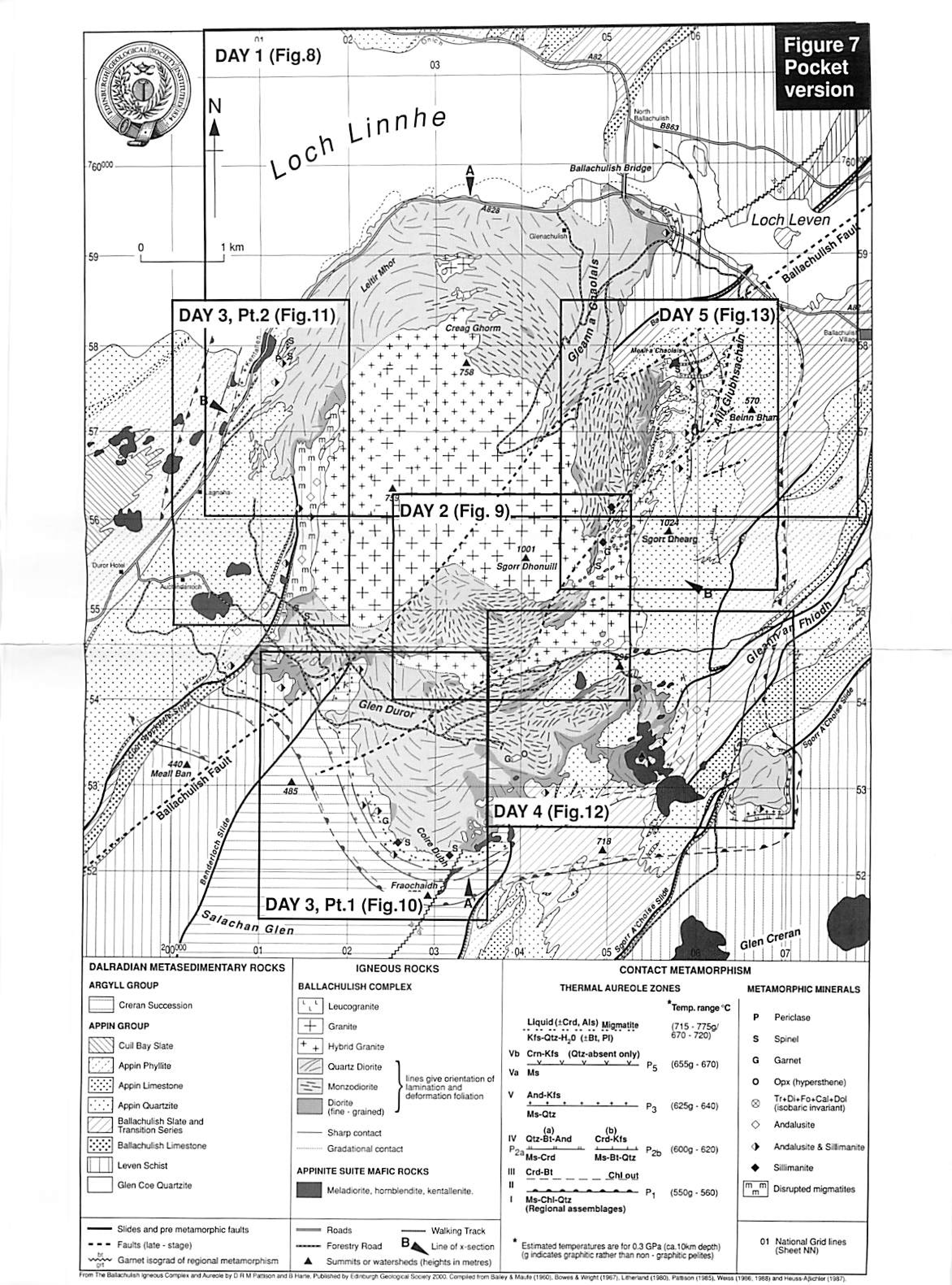
- 21:2621:26, 1 November 2015 diff hist +894 N File:EGS Ballachulish Fig 07.jpg Outline of area for field excursions Figure 7 From: Pattison, D.R.M. and Harte, B. The Ballachulish Igneous Complex and aureole: a field guide. Edinburgh : Edinburgh Geological Society, 2001. current
- 21:2421:24, 1 November 2015 diff hist +1,431 N File:EGS Ballachulish Fig 06.jpg Isobaric T-X<sub>CO2</sub>, diagram (3 kbar) for selected equilibria in the chemical system CaO-MgO-SiO<sub>2</sub>-Al<sub>2</sub>O<sub>3</sub>-H<sub>2</sub>O-CO<sub>2</sub>, showing numbered reactions discussed in the text ( Pattison & Harte, 1997: mo... current
- 21:2121:21, 1 November 2015 diff hist +604 N File:EGS Ballachulish Fig 05.jpg Isograds in carbonate rocks from the Coire Giubhsachain syncline, northeast flank of igneous complex (Paulson & 1997; modified from Masch and Heuss-Aßbichler 1991 and Ferry, 1996a). Numbering of isograds is the same as in the text (with 'C' prefix omi... current
- 21:2021:20, 1 November 2015 diff hist −22 File:EGS Ballachulish Fig 04.jpg No edit summary current
- 21:1821:18, 1 November 2015 diff hist +39 File:EGS Ballachulish Fig 04.jpg No edit summary
- 21:1721:17, 1 November 2015 diff hist +55 File:EGS Ballachulish Fig 04.jpg No edit summary
- 21:1521:15, 1 November 2015 diff hist +1,440 N File:EGS Ballachulish Fig 04.jpg Figure 4. Pressure-temperature grid of reactions in the chemical system K2O-FeO-MgO-Al2O3-SiO2-H2O for typical mineral compositions in quartz-bearing pelitic rocks from Ballachulish (Pattison Harte, 1997). Dehydration reactions below the initial meltin...
- 21:1121:11, 1 November 2015 diff hist +1,822 N File:EGS Ballachulish Fig 03.jpg Geological cross-sections through the igneous complex (see section lines on Coloured Map and Fig. 7), from Weiss (1986) and Troll and Weiss (1991). l - metasediments. Lined patient indicates pelites and semipelites; lined pattern with dots represents q... current
- 21:0921:09, 1 November 2015 diff hist +1,153 N File:EGS Ballachulish Fig 02.jpg Outline of lithostratigraphic units and major regional structures around the Ballachulish Igneous Complex. The position of the garnet isograd of regional metamorphism. Which formed prior to intrusion of the complex, is extrapolated across the area of t... current
- 21:0721:07, 1 November 2015 diff hist +1,021 N File:EGS Ballachulish Fig 01.jpg Outline map of major geological provinces in Scotland, and the distribution of Caledonian igneous complexes ('granites'); with location of the Ballachulish area. Figure 1. From: Pattison, D.R.M. and Harte, B. The Ballachulish Igneous Complex and aure... current