File list
Jump to navigation
Jump to search
This special page shows all uploaded files.
| Date | Name | Thumbnail | Size | User | Description | Versions |
|---|---|---|---|---|---|---|
| 20:55, 9 February 2019 | GSG GLA FIG 00 02.jpg (file) |  |
370 KB | Scotfot | User created page with UploadWizard | 1 |
| 16:16, 5 February 2019 | Rwanda Hydrogeology2.png (file) |  |
25 KB | Beod | 1 | |
| 16:15, 5 February 2019 | Rwanda Geology2.png (file) |  |
22 KB | Beod | 1 | |
| 10:58, 29 January 2019 | P992443.jpg (file) |  |
1.19 MB | Scotfot | Hilderston Silver Mine: Plan of known workings based upon original descriptions by Atkinson (1619); mine plan by Udny (1772, Scottish Records Office no. RHP 6654); Aitken’s description of 1693; mine abandonment plan R175D; surface observations. Figur... | 1 |
| 10:55, 29 January 2019 | P992442.jpg (file) |  |
440 KB | Scotfot | Sections of old workings at Hilderston Mine, redrawn to scale from mine abandonment plan R175D. Original annotation is shown in quotes.The section seen in a shaft on the original hanging-wall side of the vein by Aitken (18%) is in close agreement with... | 1 |
| 10:51, 29 January 2019 | P992441.jpg (file) |  |
575 KB | Scotfot | Interpretation of Bore Hole 2 (Silver Mine). Hilderston Silver Mine. Fig. 9 (partial) Location Plan and interpretation of Bore Hole 2 (Silver Mine).Symbols as for Fig. 8. Histograms show concentrations of lead and zinc in a continuous section throug... | 1 |
| 10:50, 29 January 2019 | P992440.jpg (file) |  |
139 KB | Scotfot | Location Plan of Bore Hole 2 (Silver Mine). Figure 9. From: Stephenson, D.; Fortey, N.J.; Gallagher, M.J. 1983 Polymetallic mineralisation in Carboniferous rocks at Hilderston, near Bathgate, central Scotland | 1 |
| 10:44, 29 January 2019 | P992439.jpg (file) |  |
804 KB | Scotfot | Location plan and interpreted sections of Bore 3A and 3B Aitken Bog Plantation). Symbols as for Fig. 8. Histograms on Bore Hole 3B show concentrations of lead and zinc in a continuous section from the dyke margin downwards.Figure 10. (partial) From: S... | 1 |
| 10:39, 29 January 2019 | P992438.jpg (file) |  |
851 KB | Scotfot | a: Palaeogeographic reconstruction of the Bathgate Hills area at the time of deposition of the Petershill Limestone, adapted from Jameson ( 1980). b: Generalised cross-section of the Petershiil Limestone facies (unshaded ,adapted from Jameson (1980, Fi... | 1 |
| 21:09, 28 January 2019 | P941484.jpg (file) |  |
637 KB | Scotfot | Geophysical anomaly maps. b. Total field aeromagnetic anomalies for the Falkirk district and surrounding area observed at 305 m above terrain along east-west flight lines with contour values in nT. Dashed lines labelled SRP1 etc. are the locations of s... | 1 |
| 21:03, 28 January 2019 | P941483.jpg (file) |  |
807 KB | Scotfot | Geophysical anomaly maps a. Bouguer gravity anomalies for the Falkirk district and surrounding area reduced to 01) at a density of 2.75 Mg nr3, contour values in mGal. Lines QB-1, QB-2 are quarry blast seismic refraction profiles (Davidson et al., 1984... | 1 |
| 20:58, 28 January 2019 | P941481.jpg (file) |  |
444 KB | Scotfot | Lateral extent of the Bathgate Hills Volcanic Formation. The conjectural lines are based on the outcrop and on scattered, unevenly distributed boreholes. Most boreholes are relatively shallow and volcanic rocks may be more extensive at depth. Figure 22... | 1 |
| 20:52, 28 January 2019 | P941490.jpg (file) |  |
2.91 MB | Scotfot | ''Westlothiana lizziae'' Smithson and Rolfe. Fossil skeleton of the key linking form between amphibians and reptiles, popularly known as 'Lizzie'. The 20 cm long specimen was discovered in 1988 by the commercial collector, Mr Stan Wood. The specimen wa... | 1 |
| 20:44, 28 January 2019 | P220914.jpg (file) |  |
830 KB | Scotfot | East Kirkton Limestone. Cut surface of a hand specimen showing lamination and intraformational folding. (D 5097). Plate 4 from Cameron, I B, Aitken, A M, Browne, M A E, and Stephenson, D. 1998. Geology of the Falkirk district. Memoir of the British Geo... | 1 |
| 20:33, 28 January 2019 | P002882.jpg (file) |  |
396 KB | Scotfot | East Kirkton Quarry [NS 990 092], near Bathgate. The East Kirkton Limestone in the upper part of the West Lothian Oil Shale Formation is a laminated freshwater limestone. A unique and varied terrestrial assemblage of fossils have been collected from th... | 2 |
| 13:07, 23 January 2019 | Bathgate Fig 03.jpg (file) |  |
1.22 MB | Scotfot | 2 | |
| 11:22, 23 January 2019 | Bathgate Fig 02.jpg (file) |  |
434 KB | Scotfot | Comparison of the generalized vertical section north of Linlithgow with that in the southern Bathgate Hills. Figure 2, p. 191 of 'The Geological Setting of the Southern Bathgate Hills, West Lothian, Scotland' by P.A. Smith, D. Stephenson and S.K.... | 1 |
| 11:06, 23 January 2019 | Bathgate Fig 01.jpg (file) |  |
1.88 MB | Scotfot | The geological setting of the southern Bathgate Hills. Fig. 1, pl90 of 'The Geological Setting of the Southern Bathgate Hills, West Lothian, Scotland' by PA Smith, D Stephenson and S K Monro in Transactions qf the Royal Society qf Edinburgh: Earth... | 1 |
| 17:54, 9 January 2019 | LIBERIA FINAL suitability map.png (file) |  |
3.27 MB | Beod | 1 | |
| 14:17, 9 January 2019 | Moroccofieldtrip-wpcf 740x218.jpg (file) |  |
54 KB | Beod | 1 | |
| 14:16, 9 January 2019 | Earthswatergraphic.png (file) |  |
32 KB | Beod | 1 | |
| 11:06, 9 January 2019 | TheWaterModuleFrontPage.PNG (file) |  |
844 KB | Beod | 1 | |
| 11:02, 9 January 2019 | Poster 2 final french-3.png (file) |  |
698 KB | Beod | 1 | |
| 11:01, 9 January 2019 | 2-groundwater-in-africa-poster-3.png (file) |  |
665 KB | Beod | 1 | |
| 10:56, 9 January 2019 | Poster 2 final french.png (file) | Error creating thumbnail: File with dimensions greater than 12.5 MP |
700 KB | Beod | 1 | |
| 10:56, 9 January 2019 | 2-groundwater-in-africa-poster-2.png (file) | Error creating thumbnail: File with dimensions greater than 12.5 MP |
707 KB | Beod | 2 | |
| 13:08, 12 December 2018 | Angola Hidrogeologia.png (file) |  |
46 KB | Beod | 1 | |
| 13:02, 12 December 2018 | Angola Geologia.png (file) |  |
47 KB | Beod | 1 | |
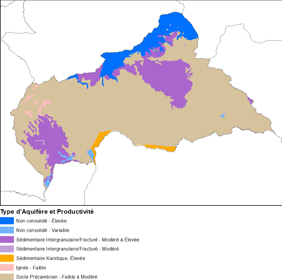
| 15:42, 11 December 2018 | RepubliqueCentrafricaine Hydrogeologie.png (file) |  |
31 KB | Beod | 1 | |
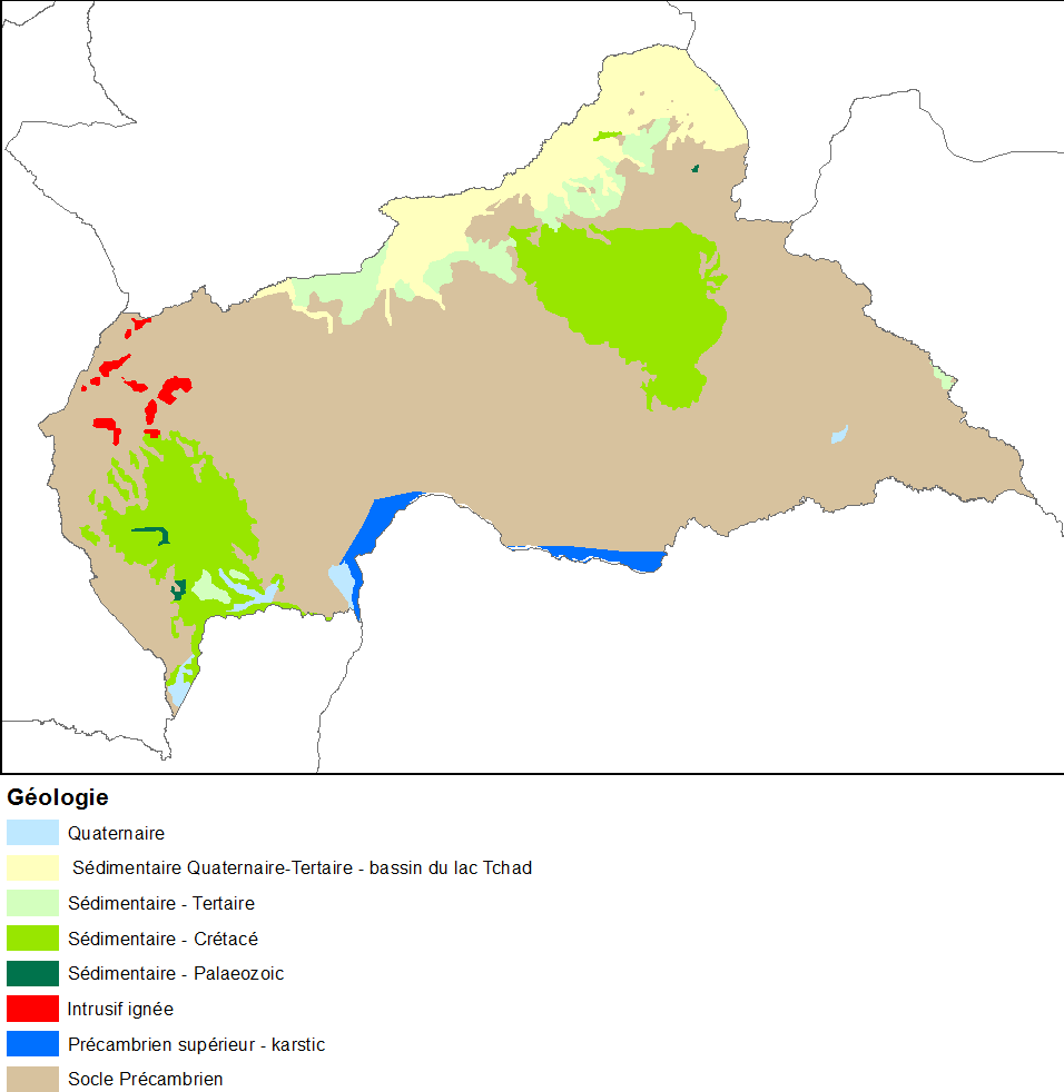
| 15:42, 11 December 2018 | RepubliqueCentrafricaine Geologie.png (file) |  |
30 KB | Beod | 1 | |
| 15:35, 11 December 2018 | Madagascar Hydrogeologie.png (file) |  |
34 KB | Beod | 1 | |
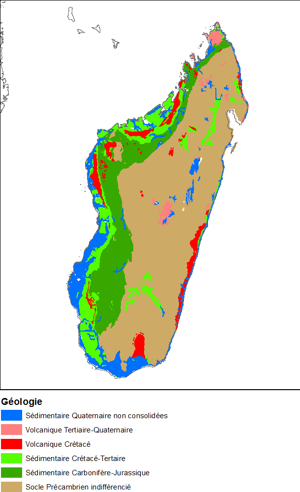
| 15:35, 11 December 2018 | Madagascar Geologie.png (file) |  |
32 KB | Beod | 1 | |
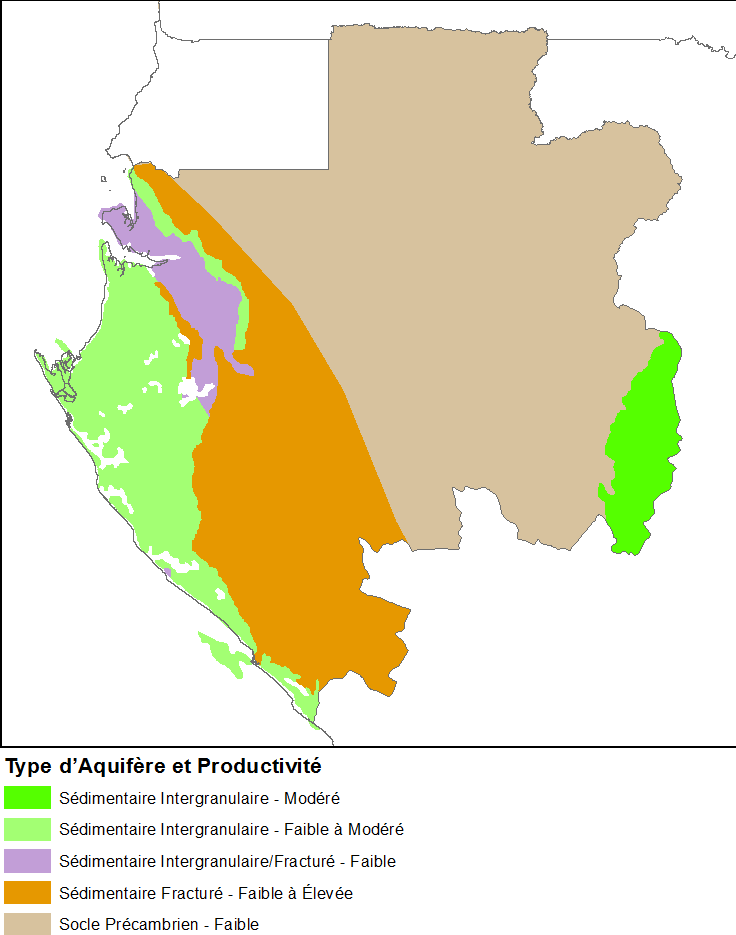
| 15:32, 11 December 2018 | Gabon Hydrogeologie.png (file) |  |
25 KB | Beod | 1 | |
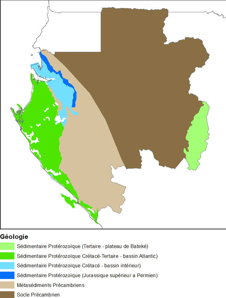
| 15:27, 11 December 2018 | Gabon Geologie.png (file) |  |
28 KB | Beod | 1 | |
| 15:21, 11 December 2018 | Cameroun Hydrogeologie.png (file) |  |
26 KB | Beod | 1 | |
| 15:20, 11 December 2018 | Cameroun Geologie.png (file) |  |
23 KB | Beod | 1 | |
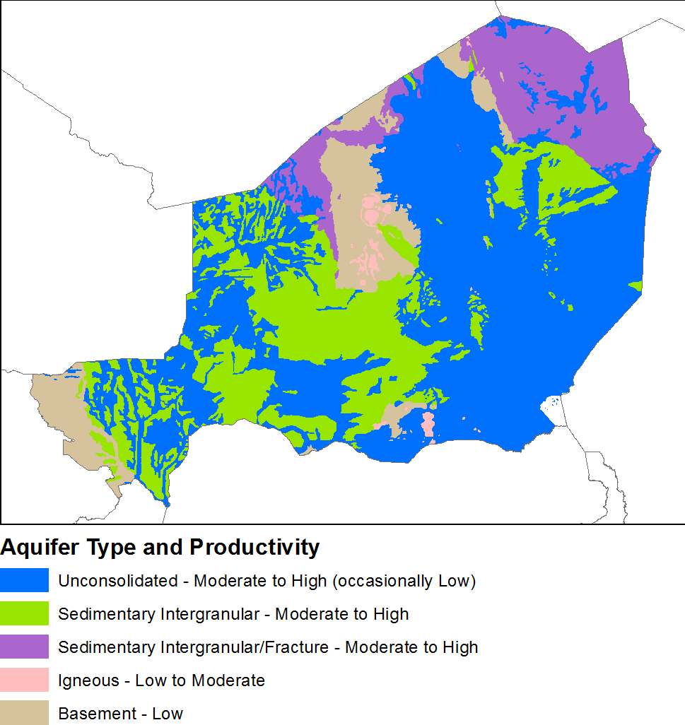
| 16:22, 12 November 2018 | Niger Hydrogeology3.png (file) |  |
45 KB | Beod | 1 | |
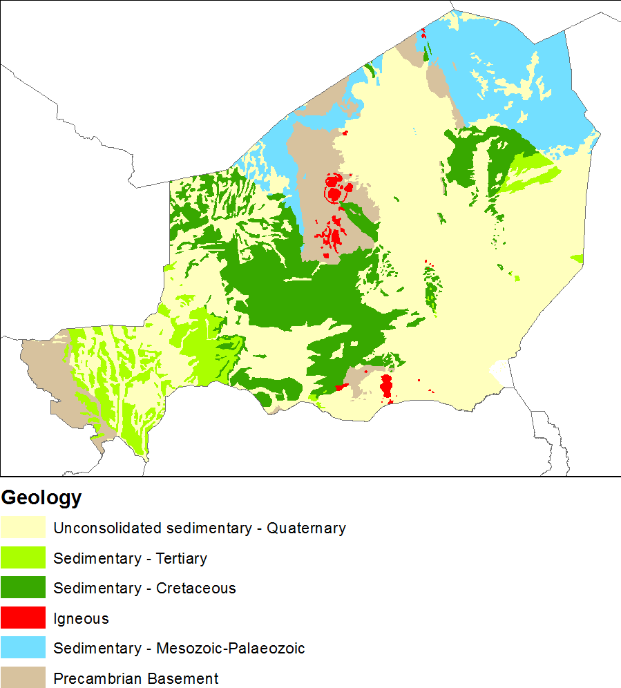
| 16:50, 8 November 2018 | Niger Geology3.png (file) |  |
41 KB | Beod | 1 | |
| 14:56, 23 October 2018 | DRC Hydrogeology3.png (file) |  |
58 KB | Beod | 1 | |
| 14:56, 23 October 2018 | DRC Geology3.png (file) |  |
56 KB | Beod | 1 | |
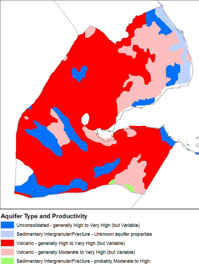
| 17:08, 22 October 2018 | Djibouti Hydrogeology2.png (file) |  |
32 KB | Beod | 1 | |
| 17:08, 22 October 2018 | Djibouti Geology2.png (file) |  |
27 KB | Beod | 2 | |
| 08:41, 19 October 2018 | OR15057screenshot6 F.jpg (file) |  |
111 KB | Dbk | 1 | |
| 08:39, 19 October 2018 | OR15057screenshot5 E.jpg (file) |  |
92 KB | Dbk | 1 | |
| 08:39, 19 October 2018 | OR15057screenshot4 D.jpg (file) |  |
68 KB | Dbk | 1 | |
| 08:37, 19 October 2018 | OR15057screenshot3 C.jpg (file) |  |
57 KB | Dbk | 1 | |
| 08:35, 19 October 2018 | OR15057screenshot2 B.jpg (file) |  |
65 KB | Dbk | 1 | |
| 08:33, 19 October 2018 | OR15057screenshot1 A.jpg (file) |  |
83 KB | Dbk | 1 | |
| 08:25, 19 October 2018 | OR15057screenshot9 7.2.3.jpg (file) |  |
104 KB | Dbk | User created page with UploadWizard | 1 |
| 08:25, 19 October 2018 | OR15057screenshot8 7.2.6.2.jpg (file) |  |
92 KB | Dbk | User created page with UploadWizard | 1 |