File list
Jump to navigation
Jump to search
This special page shows all uploaded files.
| Date | Name | Thumbnail | Size | User | Description | Versions |
|---|---|---|---|---|---|---|
| 18:17, 12 April 2022 | GA Image 0488.jpg (file) |  |
546 KB | Scotfot | Figure 54 Section showing "Warp and Trail", Stoke Newington.. Reproduced here by the kind. permission of Mr. Worthington G.. Smith, F.L.S. {{Template:GA excursions1860-1890}} == Licencing == {{GA}} | 1 |
| 18:16, 12 April 2022 | GA Image 0487.jpg (file) |  |
570 KB | Scotfot | Figure 53 Section west of Kyverdale Road, Stoke Newington. Reproduced here by the kind. permission of Mr. Worthington G.. Smith, F.L.S. {{Template:GA excursions1860-1890}} == Licencing == {{GA}} | 1 |
| 18:15, 12 April 2022 | GA Image 0486.jpg (file) |  |
873 KB | Scotfot | Figure 52 Section in Stoke Newington Pit [Reprinted by permission of the Council from Q.J.G.S vol. xxvi. Surface Soil. k. Covering bed, large flints in stiff brown clay. ? Trail] 6-8 feet. j. Brick-earth. 2.-g., e.-c. Finely laminated loams and clays. f. Peaty black clay. Beds c.-j. were 30 feet thick. {{Template:GA excursions1860-1890}} == Licencing == {{GA}} | 1 |
| 18:14, 12 April 2022 | GA Image 0485.jpg (file) |  |
178 KB | Scotfot | Figure 51 Section across the valleys of the Hackney Brook and the Lea. A Ayrsome Street. B. Stoke Newington Common. C. Stamford Hill. a. Gravels. b. London Clay {{Template:GA excursions1860-1890}} == Licencing == {{GA}} | 1 |
| 18:13, 12 April 2022 | GA Image 0484.jpg (file) |  |
329 KB | Scotfot | Figure 50 Vertical sections of the gravels of Hackney. {{Template:GA excursions1860-1890}} == Licencing == {{GA}} | 1 |
| 00:03, 6 April 2022 | GA Image 0483.jpg (file) |  |
196 KB | Scotfot | Figure 49 Section along the cliffs of Hastings and Fairlight. {{Template:GA excursions1860-1890}} = Licencing == {{GA}} | 1 |
| 22:28, 5 April 2022 | GA Image 0481.jpg (file) |  |
214 KB | Scotfot | Figure 47 Section of the southern valley of the Weald (Length of section about 4 miles) Vertical scale greatly exaggerated. {{Template:GA excursions1860-1890}} = Licencing == {{GA}} | 1 |
| 12:05, 22 March 2022 | BellinghamIndexto10kmaps.JPG (file) |  |
85 KB | Scotfot | Bellingham Sheet 13. Index map of available Geological Survey Six-Inch National Grid Maps. | 1 |
| 11:14, 22 March 2022 | 1001481 2000.jpg (file) |  |
1.35 MB | Scotfot | Bellingham Sheet 13 Geological Survey of Great Britain, England and Wales 1:50,000 map. Solid Edition. https://largeimages.bgs.ac.uk/iip/mapsportal.html?id=1001481 Full resolution version | 1 |
| 11:13, 22 March 2022 | 1001480 2000.jpg (file) |  |
1.35 MB | Scotfot | Bellingham Sheet 13 Geological Survey of Great Britain, England and Wales 1:50,000 map. Drift Edition. https://largeimages.bgs.ac.uk/iip/mapsportal.html?id=1001480 Full resolution version | 1 |
| 12:22, 8 March 2022 | OR14011.jpg (file) |  |
112 KB | Ajhil | OR/14/11 Front Cover | 1 |
| 11:05, 6 March 2022 | P710267.jpg (file) |  |
161 KB | Scotfot | Operator sitting at a IBM 1130 minicomputer. Computer Unit, Exhibition Road, Institute of Geological Sciences. | 1 |
| 11:04, 6 March 2022 | P710266.jpg (file) |  |
163 KB | Scotfot | Operator sitting at a IBM 1130 minicomputer. Computer Unit, Exhibition Road, Institute of Geological Sciences. | 1 |
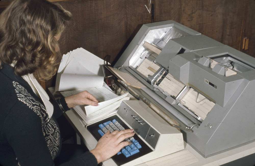
| 11:03, 6 March 2022 | P710265.jpg (file) |  |
144 KB | Scotfot | IBM punched card input machine. Computer Unit, Exhibition Road, Institute of Geological Sciences. | 1 |
| 11:03, 6 March 2022 | P710264.jpg (file) |  |
144 KB | Scotfot | IBM punched card input machine. Computer Unit, Exhibition Road, Institute of Geological Sciences. | 1 |
| 11:02, 6 March 2022 | P710263.jpg (file) |  |
153 KB | Scotfot | Punched card jobs. Computer Unit, Exhibition Road, Institute of Geological Sciences. | 1 |
| 11:02, 6 March 2022 | P710262.jpg (file) |  |
151 KB | Scotfot | Punched card jobs. Computer Unit, Exhibition Road, Institute of Geological Sciences. | 1 |
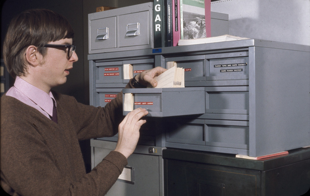
| 11:00, 6 March 2022 | P710261.jpg (file) |  |
145 KB | Scotfot | Punched card storage trays. Computer Unit, Exhibition Road, Institute of Geological Sciences. | 1 |
| 11:00, 6 March 2022 | P710260.jpg (file) |  |
140 KB | Scotfot | Punched card storage trays. Computer Unit, Exhibition Road, Institute of Geological Sciences. | 1 |
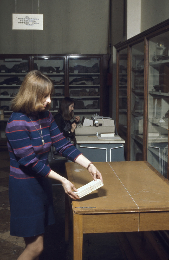
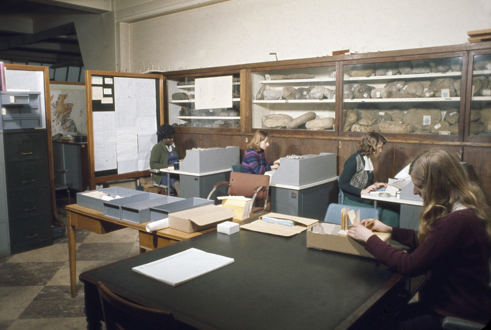
| 10:58, 6 March 2022 | P710259.jpg (file) |  |
180 KB | Scotfot | Computer Unit. Three keypunch operators | 1 |
| 10:58, 6 March 2022 | P710258.jpg (file) |  |
173 KB | Scotfot | Keypunch machine. Computer Unit, Exhibition Road, Institute of Geological Sciences. | 1 |
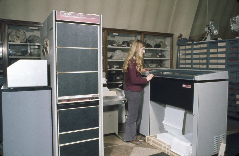
| 10:57, 6 March 2022 | P710257.jpg (file) |  |
158 KB | Scotfot | The Digital PDP-11 computer and fanfold paper printer. Computer Unit, Exhibition Road, Institute of Geological Sciences. | 1 |
| 10:57, 6 March 2022 | P710256.jpg (file) |  |
137 KB | Scotfot | Punched card machine (Verifier?). Computer Unit, Exhibition Road, Institute of Geological Sciences. | 1 |
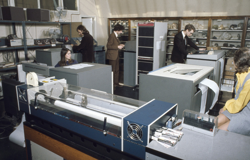
| 10:56, 6 March 2022 | P710255.jpg (file) |  |
183 KB | Scotfot | Computer Unit. Plotter, two fanfold printers. The tall cabinet is the PDP-11 computer. Computer Unit, Exhibition Road, Institute of Geological Sciences. | 1 |
| 10:55, 6 March 2022 | P710254.jpg (file) |  |
172 KB | Scotfot | Computer Unit. Three keypunch operators. Computer Unit, Exhibition Road, Institute of Geological Sciences. | 1 |
| 10:53, 6 March 2022 | P710253.jpg (file) |  |
147 KB | Scotfot | Inserting a disk cartridge. Computer Unit, Exhibition Road, Institute of Geological Sciences. | 1 |
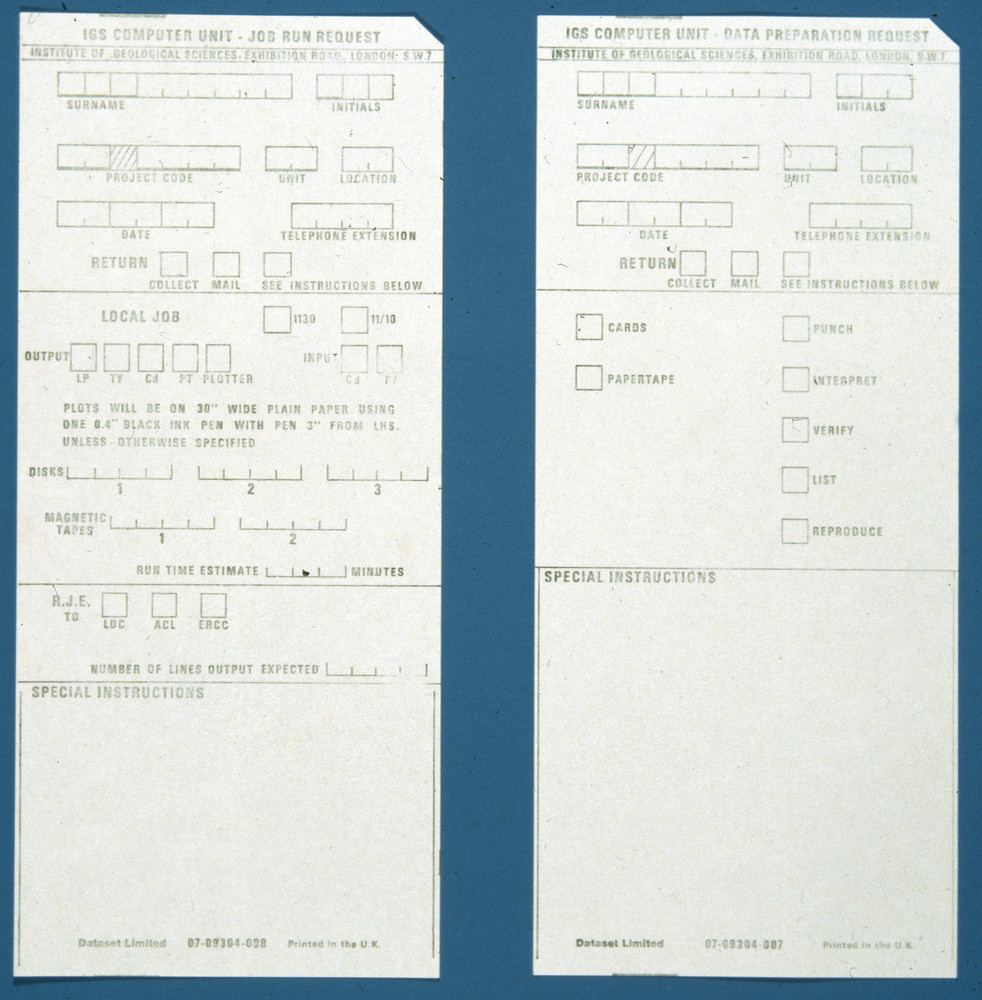
| 10:51, 6 March 2022 | P710252.jpg (file) |  |
263 KB | Scotfot | Job run request card. Computer Unit, Exhibition Road, Institute of Geological Sciences. | 1 |
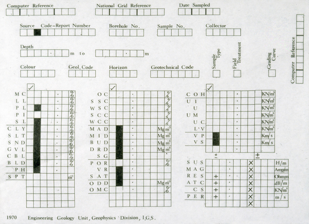
| 10:50, 6 March 2022 | P710251.jpg (file) |  |
205 KB | Scotfot | Engineering Geology Unit input form. Computer Unit, Exhibition Road, Institute of Geological Sciences. | 1 |
| 10:49, 6 March 2022 | P710250.jpg (file) |  |
212 KB | Scotfot | Engineering Geology Unit input form. Computer Unit, Exhibition Road, Institute of Geological Sciences. | 1 |
| 10:48, 6 March 2022 | P710249.jpg (file) |  |
213 KB | Scotfot | Fortran Coding Form. Computer Unit, Exhibition Road, Institute of Geological Sciences. | 1 |
| 10:47, 6 March 2022 | P710248.jpg (file) |  |
281 KB | Scotfot | Petrographical data input sheet. Computer Unit, Exhibition Road, Institute of Geological Sciences. | 1 |
| 10:56, 5 March 2022 | P008939.jpg (file) |  |
159 KB | Scotfot | Institute of Geological Sciences Computer Unit staff. Taken in the Reserve and study gallery of the Geological Museum, Exhibition Road. Including visiting staff from Murchison House and Dr. Henley from Keyworth. Left to right, top row M.F. Horder, D.G. Farmer, G.G. Baxter, A.J.H. Redman, J.F. Wheeler, J. Hargreaves, T.V. Loudon, P.L. Hunt, C.B. Jones, S. Henley. Left to right, lower row G.E. Pickup, M.A. Register, H.A. Phelan, L.D. Kinnaird, A.L. Macintosh, C. Steven. The twins on the lower l... | 1 |
| 21:15, 4 March 2022 | LoudonScenarioFrontCover.JPG (file) |  |
55 KB | Scotfot | A scenario for systems geology: suggestions concerning the emerging geoscience knowledge system and the future geological map. BGS Research Report RR/11/05. Front cover. | 1 |
| 21:10, 4 March 2022 | BGS VicLoudon 1000.jpg (file) |  |
238 KB | Scotfot | Dr. T. Victor (Vic) Loudon. Portrait. Photographer: Brian McIntyre. | 1 |
| 15:25, 4 March 2022 | OR14010fig2.jpg (file) |  |
531 KB | Ajhil | 1 | |
| 15:25, 4 March 2022 | OR14010fig1.jpg (file) |  |
514 KB | Ajhil | 1 | |
| 12:55, 4 March 2022 | TchadResEas500k.JPG (file) |  |
79 KB | Beod | 1 | |
| 12:43, 1 March 2022 | SADC-HG-map.JPG (file) |  |
58 KB | Beod | 1 | |
| 15:39, 28 February 2022 | HGCLMapTanzania.JPG (file) |  |
153 KB | Beod | 1 | |
| 15:38, 28 February 2022 | MapHGAngola.JPG (file) |  |
150 KB | Beod | 1 | |
| 15:23, 28 February 2022 | Hydrogeological-map-of-Namibia-Source-Christelis-and-Struckmeier-2011.png (file) |  |
120 KB | Beod | 1 | |
| 15:22, 28 February 2022 | Hgcl-map-Zambia-BGR.png (file) |  |
170 KB | Beod | 1 | |
| 15:00, 28 February 2022 | AfricaHGCLFmts.JPG (file) |  |
172 KB | Beod | 1 | |
| 14:57, 28 February 2022 | CarteHGQAfrique.JPG (file) |  |
77 KB | Beod | 1 | |
| 14:52, 28 February 2022 | AqProdAfrica.jpg (file) |  |
87 KB | Beod | 1 | |
| 14:47, 28 February 2022 | GWResMapAfrica2018.JPG (file) |  |
128 KB | Beod | 1 | |
| 20:25, 24 February 2022 | GA Image 0478.jpg (file) |  |
155 KB | Scotfot | Figure 44 Loam-with-Flints in the Pebble-Beds at Caterham. Scale—10 Feet To 1 Inch. {{Template:GA excursions1860-1890}} == Licencing == {{GA}} | 1 |
| 20:23, 24 February 2022 | GA Image 0477.jpg (file) |  |
161 KB | Scotfot | Figure 43 Cavity in the Caterham Gravel Pits. Scale—10 Feet To 1 Inch. {{Template:GA excursions1860-1890}} == Licencing == {{GA}} | 1 |
| 20:04, 24 February 2022 | GA Image 0480.jpg (file) |  |
210 KB | Scotfot | Figure 46 Section of the central elevation of the Weald. (About 12 Miles.) Explanation of signs.—h′ Ashdown Sands. h″ Wadhurst Clay. h‴ Tunbridge-Wells Sand. h1 Weald Clay. h2′ Atherfield Clay. h2″ Hythe Beds. h2‴ Sandgate Beds. h2″ Folkestone Beds. h3 Gault. h4 Upper Greensand. h5 Chalk. {{Template:GA excursions1860-1890}} = Licencing == {{GA}} | 1 |
| 19:57, 24 February 2022 | GA Image 0479.jpg (file) | 173 KB | Scotfot | Figure 45 Section of the Northern Valley of The Weald. (About 9 Miles.) Explanation of signs: h′ Ashdown Sands. h″ Wadhurst Clay. h‴ Tunbridge-Wells Sand. h1 Weald Clay. h2′ Atherfield Clay. h2″ Hythe Beds. h2‴ Sandgate Beds. h2″ Folkestone Beds. h3 Gault. h4 Upper Greensand. h5 Chalk. {{Template:GA excursions1860-1890}} = Licencing == {{GA}} | 1 |