File list
Jump to navigation
Jump to search
This special page shows all uploaded files.
| Date | Name | Thumbnail | Size | User | Description | Versions |
|---|---|---|---|---|---|---|
| 23:55, 16 December 2022 | P915395.jpg (file) |  |
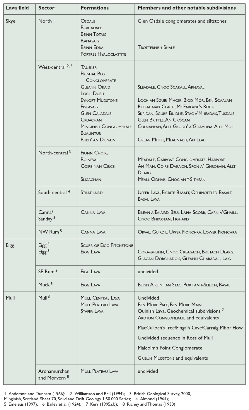
336 KB | Scotfot | Table 9 Paleocene lava fields in the Hebridean Igneous Province. 1 Anderson and Dunham (1966); 2 Williamson and Bell (1994); 3 British Geological Survey, 2000, Minginish, Scotland. Sheet 70, Solid and Drift Geology 1:50 000 Series; 4 Almond (1964); 5 Emeleus (1997); 6 Bailey et al. (1924); 7 Kerr (1995a,b); 8 Richey and Thomas (1930). From: Emeleus, C H, and Bell, B R. 2005. British regional geology: The Palaeogene volcanic districts of Scotland. Fourth edition. Keyworth, Nottingham: British... | 1 |
| 23:54, 16 December 2022 | P915394.jpg (file) |  |
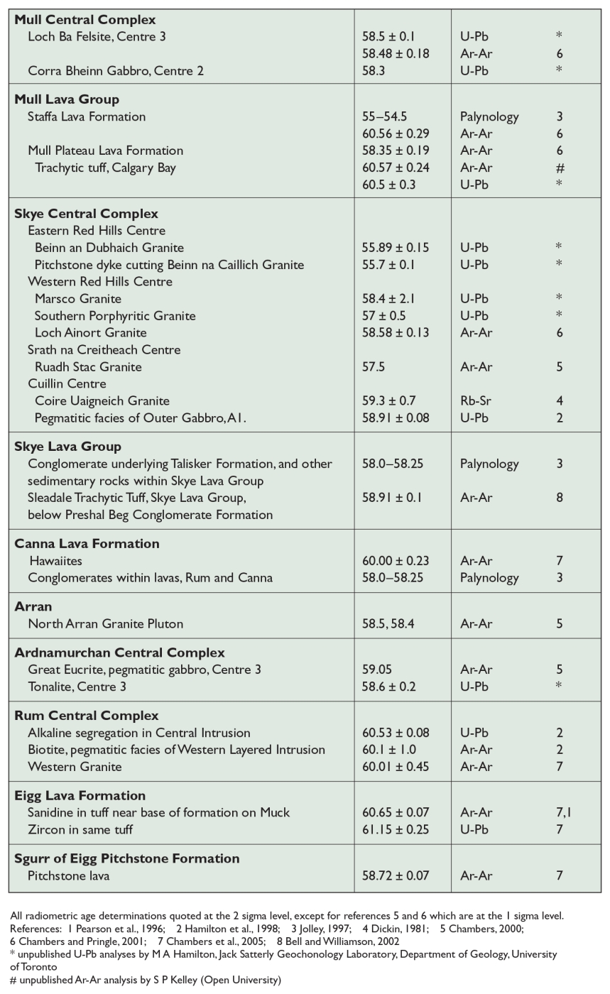
409 KB | Scotfot | Table 8 Radiometric and palynological age determinations on Palaeogene rocks from the Hebridean Igneous Province. At the time of compilation, the radiometric and palynological data were not fully reconciled (Jolley et al., 2002). Ages are in million years (Ma). All radiometric age determinations quoted at the 2 sigma level, except for references 5 and 6 which are at the 1 sigma level. References: 1 Pearson et al., 1996; 2 Hamilton et al., 1998; 3 Jolley, 1997; 4 Dickin, 1981; 5 Chambers, 2000... | 1 |
| 23:53, 16 December 2022 | P915393.jpg (file) |  |
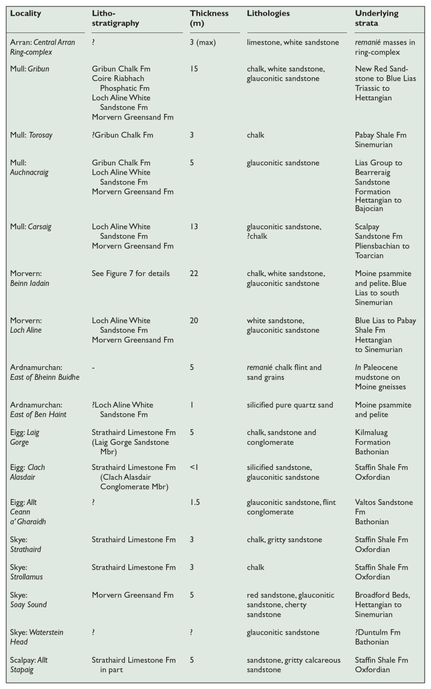
337 KB | Scotfot | Table 7 Cretaceous strata in the Inner Hebrides and the Isle of Arran. From: Emeleus, C H, and Bell, B R. 2005. British regional geology: The Palaeogene volcanic districts of Scotland. Fourth edition. Keyworth, Nottingham: British Geological Survey. | 1 |
| 23:49, 16 December 2022 | P915392.jpg (file) |  |
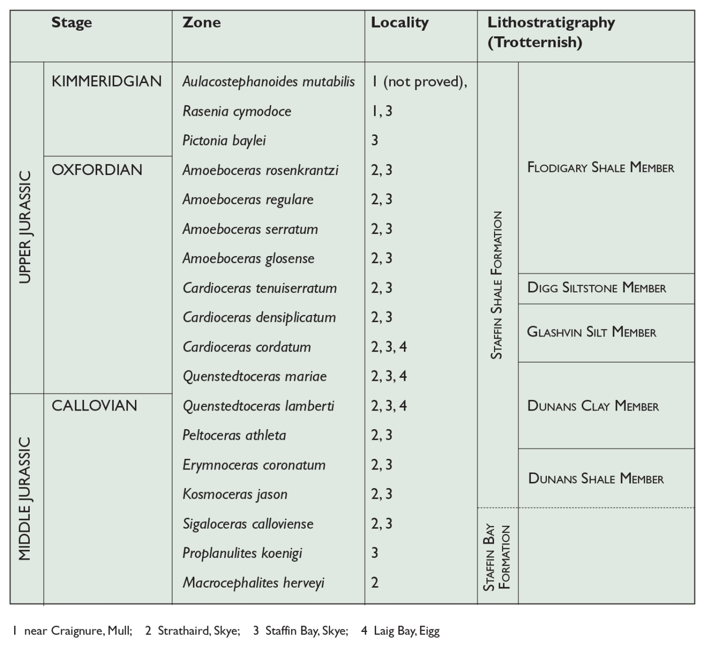
335 KB | Scotfot | Table 6 Ammonite zonal sequence in the upper Middle Jurassic (Callovian) and the Upper Jurassic of the Inner Hebrides (based on Richey, 1961 and Cope, 1995).The correlation with the major lithostratigraphical divisions is based on Sykes (1975) and Sykes and Calloman (1979), with additional information from N Morton and J D Hudson (2000 and 2004). From: Emeleus, C H, and Bell, B R. 2005. British regional geology: The Palaeogene volcanic districts of Scotland. Fourth edition. Keyworth, Nottingh... | 1 |
| 23:47, 16 December 2022 | P915391.jpg (file) |  |
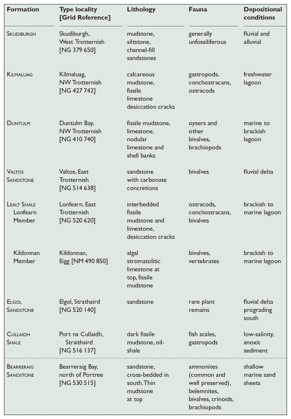
323 KB | Scotfot | Table 5 Great Estuarine Group and Bearreraig Sandstone Formation in the Inner Hebrides. From: Emeleus, C H, and Bell, B R. 2005. British regional geology: The Palaeogene volcanic districts of Scotland. Fourth edition. Keyworth, Nottingham: British Geological Survey. | 1 |
| 23:44, 16 December 2022 | P915390.jpg (file) |  |
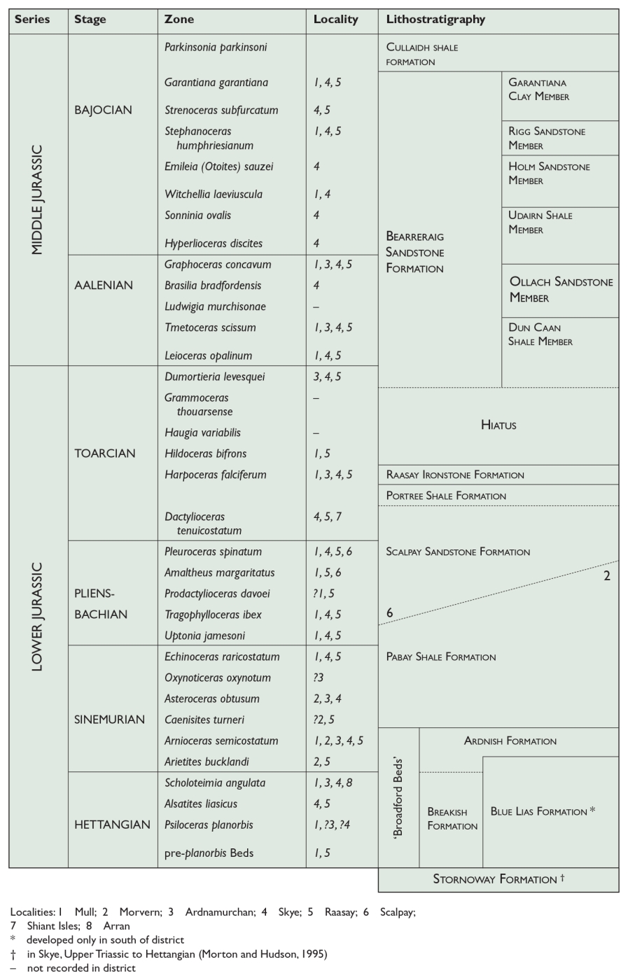
304 KB | Scotfot | Table 4 Ammonite zonal sequence in the Lower Jurassic and part of the Middle Jurassic of the Inner Hebrides (based on Richey, 1961 and Cope, 1995).The correlation with the major lithostratigraphical divisions is based on Morton and Dietl (1989), Howarth (1992), Hesselbo et al. (1998), Morton (1999b), and Hesselbo and Coe (2000) with additional information from N Morton and J D Hudson, 2000 and 2004. Members are from the type area of the Bearreraig Sandstone Formation, in Trotternish, Skye. Lo... | 1 |
| 23:42, 16 December 2022 | P915389.jpg (file) |  |
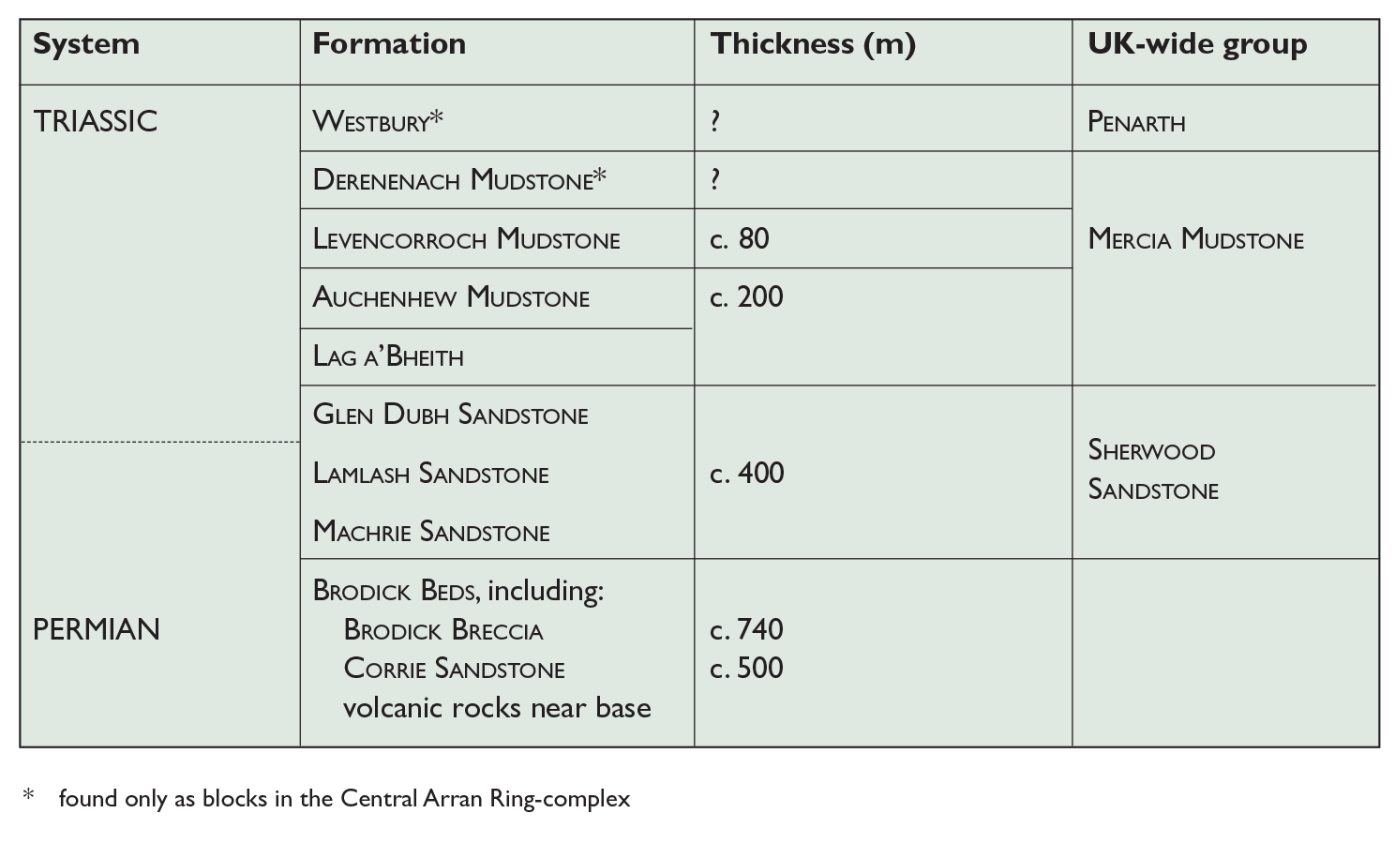
190 KB | Scotfot | Table 3 Permian and Triassic strata of the Isle of Arran. From: Emeleus, C H, and Bell, B R. 2005. British regional geology: The Palaeogene volcanic districts of Scotland. Fourth edition. Keyworth, Nottingham: British Geological Survey. | 1 |
| 23:41, 16 December 2022 | P915388.jpg (file) |  |
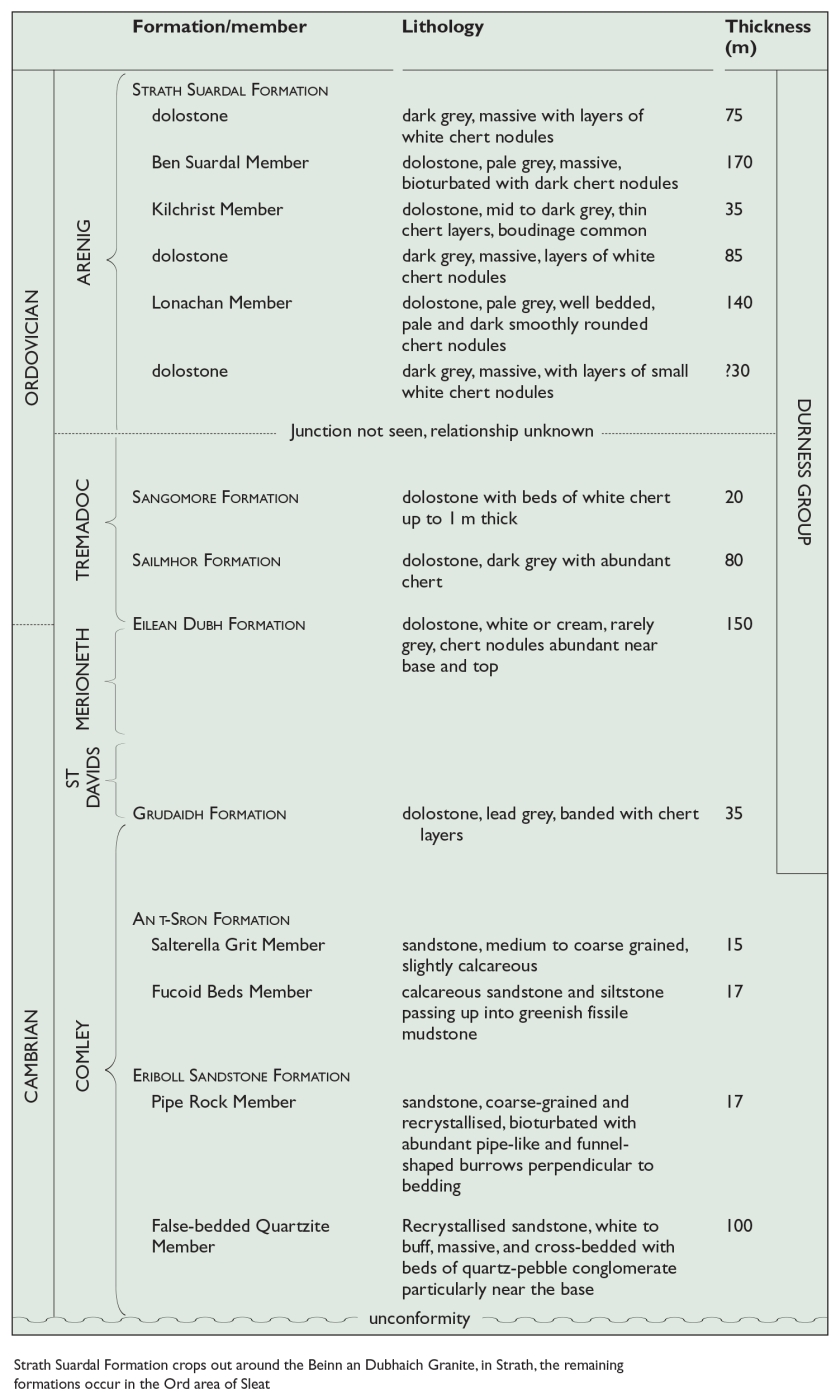
309 KB | Scotfot | Table 2 Cambrian and Ordovician strata of Skye, based on Sheet 71W Broadford, 2002. Strath Suardal Formation crops out around the Beinn an Dubhaich Granite, in Strath, the remaining formations occur in the Ord area of Sleat. From: Emeleus, C H, and Bell, B R. 2005. British regional geology: The Palaeogene volcanic districts of Scotland. Fourth edition. Keyworth, Nottingham: British Geological Survey. | 1 |
| 23:39, 16 December 2022 | P915387.jpg (file) |  |
264 KB | Scotfot | Table 1 Torridon and Sleat groups on Rum and Skye. From: Emeleus, C H, and Bell, B R. 2005. British regional geology: The Palaeogene volcanic districts of Scotland. Fourth edition. Keyworth, Nottingham: British Geological Survey. | 1 |
| 10:38, 19 October 2022 | 19782209.jpg (file) |  |
401 KB | Scotfot | British Geological Survey example field slip NX54NE(N)- a double National Grid field slip. | 1 |
| 12:52, 18 October 2022 | P936666.jpg (file) |  |
449 KB | Scotfot | Chromium and magnesium distribution in surficial marine sediments off Dibidil, Rum. From: (Figure 65) Emeleus, C.H. 1997. Geology of Rum and the adjacent islands Memoir for 1:50 000 Geological Sheet 60 (Scotland). | 1 |
| 12:49, 18 October 2022 | P936665.jpg (file) |  |
499 KB | Scotfot | Chromium and magnesium distribution in surficial marine sediments off Harris, Rum. From: Emeleus, C.H. 1997. Geology of Rum and the adjacent islands Memoir for 1:50 000 Geological Sheet 60 (Scotland) | 1 |
| 12:43, 18 October 2022 | P936564.jpg (file) |  |
577 KB | Scotfot | Geological sketch map of the Rum district, Sheet 60. Based on BGS 1:250 000 Series sheets Tiree and Little Minch, with some additions from the 3rd (1:50 000) edition of Sheet 60 (Rum). Figure 1 from Emeleus, C.H. 1997. Geology of Rum and the adjacent islands Memoir for 1:50 000 Geological Sheet 60 (Scotland) | 1 |
| 19:34, 14 October 2022 | DS WeaklawFig6.jpg (file) |  |
319 KB | Scotfot | The western face of the western Hanging Rock, showing the complex reverse fault-zone represented diagrammatically in Figure 2. Figure 6 from Stephenson, D. Relative ages of the Weaklaw Tuffs, the Hanging Rocks breccias and the Marine Villa Tuffs. Addendum to localities 5, 6, 7 and 8. North Berwick, Yellow Craig to Cheese Bay - an excursion Copyright: D. Stephenson. 2022. | 1 |
| 19:31, 14 October 2022 | DS WeaklawFig5.jpg (file) |  |
312 KB | Scotfot | The western Hanging Rock. A mass of coarse pyroclastic breccia is juxtaposed against Weaklaw Tuffs at the base of the cliff and bedded Marine Villa Tuffs above by a reverse fault trending parallel to the cliff and dipping towards the camera at 40 to 50 degrees. The cliffs here are crumbly and inaccessible but the higher beds can be seen at the Smuggler’s Caves, some 50 m to the west. Figure 5 from Stephenson, D. Relative ages of the Weaklaw Tuffs, the Hanging Rocks breccias and the Marine Vi... | 1 |
| 19:27, 14 October 2022 | DS WeaklawFig4.jpg (file) |  |
355 KB | Scotfot | The key locality at NT 5016 8595, viewed towards the north-east. Marine Villa Tuffs in the cliff; blocks along the syncline axis; and thin skin of Marine Villa Tuffs just above point of stick. Note the coarse texture of the Weaklaw Tuffs in the foreground. On the rock platform in the distance (top left) is a horizontal feature formed by the basal Marine Villa Tuffs. Figure 4 from Stephenson, D. Relative ages of the Weaklaw Tuffs, the Hanging Rocks breccias and the Marine Villa Tuffs. Addendu... | 1 |
| 19:18, 14 October 2022 | DS WreaklawFig2.jpg (file) |  |
95 KB | Scotfot | Sketch section NW to SE across the Hanging Rocks to illustrate emplacement of pyroclastic breccias of the Weaklaw Vent against younger volcanic rocks by a complex high-angle reverse fault trending parallel to the cliff line. The sketch is a stylised view based upon a photograph of the western face of the western Hanging Rock (Figure 6). Most of the face above the base of the Marine Villa Tuffs is crumbly and inaccessible and hence parts of the interpretation might be inaccurate. Figure 2 fro... | 1 |
| 18:05, 14 October 2022 | DS WreaklawFig 1.jpg (file) |  |
100 KB | Scotfot | Sketch section along the high-water mark, from Marine Villa to the beach west of the Hanging Rocks. The inset shows detailed relationships at the key locality [NT 5016 8595]. Figure 1 from Stephenson, D. Relative ages of the Weaklaw Tuffs, the Hanging Rocks breccias and the Marine Villa Tuffs. Addendum to localities 5, 6, 7 and 8. North Berwick, Yellow Craig to Cheese Bay - an excursion Copyright: D. Stephenson. 2022. | 1 |
| 17:53, 14 October 2022 | DS WeaklawFig3.jpg (file) |  |
395 KB | Scotfot | The key locality at NT 5016 8595, viewed towards the south-west. Well-bedded Marine Villa Tuffs in the low cliff on the left dip to the right (north-west} at c. 30 degrees. The fallen blocks lie along the axis of an open syncline. To the right (north-west) of the blocks, a thin ‘skin’ of Marine Villa Tuffs can be seen draping over a very shallow domed surface (with rucksack) of paler, coarse, massive Weaklaw Tuffs, that is elongated away from the camera. A dark recess in the cliff in the dist... | 1 |
| 23:09, 11 October 2022 | 17985252.jpg (file) |  |
462 KB | Scotfot | Example 1:10560 geological map. Fairdrawn, hand coloured - watercolours, signed Clean Copy (Standard). | 1 |
| 22:53, 11 October 2022 | 13728352.jpg (file) |  |
170 KB | Scotfot | Example 1:10000 geological map. Digital Deposit Copy. A digitally produced map, plotted, approval signatures added and then scanned. | 1 |
| 21:33, 11 October 2022 | 19899104.jpg (file) |  |
315 KB | Scotfot | Example 1:10,000 geological map - Unpublished 'Fairdrawn' geological standard. | 1 |
| 21:00, 7 October 2022 | P015137.jpg (file) |  |
245 KB | Scotfot | Colonel Templar cruise, North-east Atlantic May-June 2000. The ship's stern during a hurricane, Hatton Bank. Date taken: 01/05/2000 Photographer: Smith, D. | 1 |
| 19:24, 7 October 2022 | P218678.jpg (file) |  |
138 KB | Scotfot | Burnmouth. Divers preparing for work at Burnmouth, Berwickshire. Left to right, R.A. Eden, J. Davidson, A. Chambers. British Geological Survey Continental Shelf No. 2 Unit. 1968. | 1 |
| 13:17, 4 October 2022 | Flag of france.png (file) |  |
108 bytes | Beod | 1 | |
| 08:58, 3 October 2022 | 13439329.jpg (file) |  |
216 KB | Scotfot | Example National Grid series geological map. An unpublished "Standard". Hand coloured with crayon. | 1 |
| 08:52, 3 October 2022 | 12974405.jpg (file) |  |
219 KB | Scotfot | Example National Grid series geological map. Published and litho printed in colour. | 1 |
| 22:28, 2 October 2022 | 12837973.jpg (file) |  |
153 KB | Scotfot | Example County Series geological map, published, printed in colour. | 1 |
| 22:18, 2 October 2022 | 13593365.jpg (file) |  |
176 KB | Scotfot | Example County Series geological map, published, uncoloured "lines edition". | 1 |
| 22:07, 2 October 2022 | 13463250.jpg (file) |  |
191 KB | Scotfot | Example County Series geological map, full sheet, manuscript, hand-coloured "Standard". | 1 |
| 21:06, 2 October 2022 | 13840807.jpg (file) |  |
208 KB | Scotfot | Example County Series geological map. Unpublished, geological lines are in manuscript, hand coloured (watercolours). | 1 |
| 21:03, 2 October 2022 | 13840771.jpg (file) |  |
170 KB | Scotfot | Example County Series map. Quarter sheet, published, hand-coloured for solid. Another map would take the same published map but hand-colour it for Drift. Standard Pattern Copy. | 1 |
| 20:55, 2 October 2022 | 13593991.jpg (file) |  |
198 KB | Scotfot | Example County Series map. Full sheet, Uncoloured (lines) edition. | 1 |
| 20:50, 2 October 2022 | 13598682.jpg (file) |  |
213 KB | Scotfot | Example County Series, full sheet. Published and hand-coloured. | 1 |
| 17:21, 14 August 2022 | Manchester Office Extract from Hansard.jpg (file) |  |
240 KB | Scotfot | Extract from Hansard. Monday 25th July, 1938. Column 2716. Regarding the removal from Manchester of the branch office of the Geological Survey. | 1 |
| 17:14, 14 August 2022 | Manchester Office plan 2.jpg (file) |  |
190 KB | Scotfot | Premises at 250 Oxford Road, Manchester 13. Plan of first floor. Date on stamp: May 5. 1939. | 1 |
| 17:11, 14 August 2022 | Manchester Office plan 1.jpg (file) |  |
212 KB | Scotfot | Office plan, 270 Oxford Road, Manchester. Manchester Office, Geological Survey of Great Britain. Date on stamp: 10.2.39. | 1 |
| 12:32, 14 August 2022 | Clarendon House.jpg (file) |  |
486 KB | Scotfot | Clarendon House Hotel, prior to it being converted into offices. Location of the First Newcastle Office, Geological Survey of Great Britain. | 1 |
| 11:55, 14 August 2022 | BGS Murchison House 02.jpg (file) |  |
195 KB | Scotfot | Murchison House - the Scottish Survey headquarters c. 1976 when the building opened. | 1 |
| 11:55, 14 August 2022 | BGS Murchison House 01.jpg (file) |  |
225 KB | Scotfot | Murchison House - the Scottish Survey headquarters c. 1976 when the building opened. | 1 |
| 08:35, 14 August 2022 | Newcastle office plan 1923.jpg (file) |  |
235 KB | Scotfot | Plan of the Survey offices, Clarendon House Newcastle upon Tyne "New Office June 1923" | 1 |
| 08:32, 14 August 2022 | Newcastle office plan.jpg (file) |  |
224 KB | Scotfot | Plan of the Survey offices at Clarendon House, Newcastle upon Tyne. No date. | 1 |
| 14:12, 13 August 2022 | BGS image York Office staff -rear.jpg (file) |  |
32 KB | Scotfot | York Office staff, 1935, Geological Survey of Great Britain. Rear of photograph. 14 Parliament Street. Back, G.H. Mitchell, R.H. Lennie. Front: J.V. Stephens, C.N.E. Bromehead, W.N. Edwards. | 1 |
| 14:07, 13 August 2022 | BGS image York Office staff.jpg (file) |  |
281 KB | Scotfot | York Office staff, 1935, Geological Survey of Great Britain. 14 Parliament Street. Back, G.H. Mitchell, R.H. Lennie. Front: J.V. Stephens, C.N.E. Bromehead, W.N. Edwards. | 1 |
| 13:38, 12 August 2022 | BernardSmithLetter1000.jpg (file) |  |
264 KB | Scotfot | Letter from Bernard Smith regarding the change of location of the Whitehaven Office from Oddfellow's Buildings, Queen Street to St. Nicholas Chambers, Church Street. | 1 |
| 13:29, 12 August 2022 | BGSWhitehavenOffice1926 1000.jpg (file) |  |
191 KB | Scotfot | Group photograph showing the staff of the Geological Survey of Great Britain Whitehaven Office. The 1926 (1927) staff photograph shows the staff were: B. Smith, F.M. Trotter, J. Kidd, E.E.L. Dixon, J. Eastwood and S.E. Hollingworth. | 1 |
| 22:47, 5 August 2022 | P707315.jpg (file) |  |
632 KB | Scotfot | Dr. Peter Aubrey Sabine. Taken at the naming ceremony of the Sir Kingsley Dunham Centre in 1990. | 1 |
| 23:06, 29 June 2022 | 19750612.jpg (file) |  |
482 KB | Scotfot | Example County Series field slip, Sutherland 71 NW, c.1886. Back. | 1 |
| 22:59, 29 June 2022 | 19750611.jpg (file) |  |
1.18 MB | Scotfot | Example BGS fieldslip for Sutherland 71 NW. This is a quarter of a six inch to the mile full sheet. Front. | 1 |
| 22:40, 29 June 2022 | BGS 19702048.jpg (file) |  |
1.12 MB | Scotfot | British Geological Survey example field slip SH45SE/NE in Gwynedd. Surveyed by C.J.N. Fletcher 1980. Back. Exceptionally detailed notes relating to sites numbered on the front of the fieldslip. | 1 |