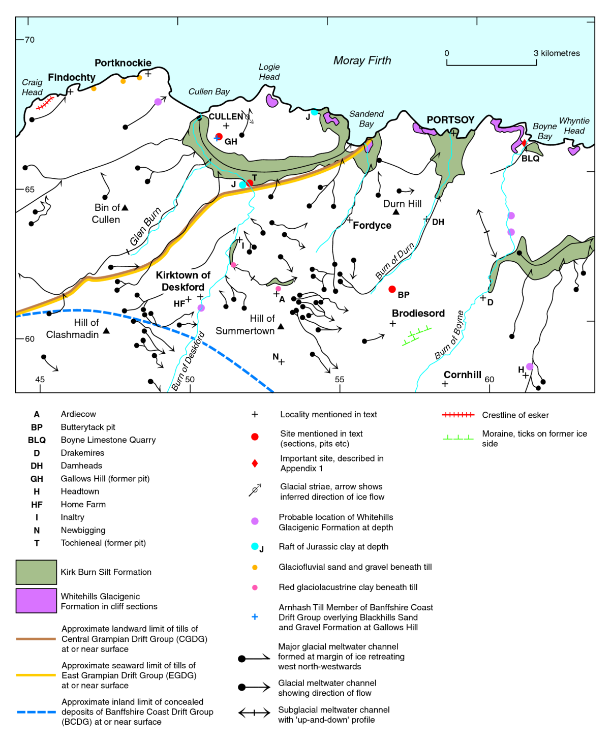
Boyne Limestone Quarry - locality, Cainozoic of north-east Scotland
| Merritt, J W, Auton, C A, Connell, E R, Hall, A M, and Peacock, J D. 2003. Cainozoic geology and landscape evolution of north-east Scotland. Memoir of the British Geological Survey, sheets 66E, 67, 76E, 77, 86E, 87W, 87E, 95, 96W, 96E and 97 (Scotland).
Contributors: J F Aitken, D F Ball, D Gould, J D Hansom, R Holmes, R M W Musson and M A Paul. |
Boyne Limestone Quarry

The Quaternary sequence here (NJ 612 659) (P915372) comprises a basal, partly weathered till thought to predate the last (Ipswichian) interglacial, and units of till and glaciotectonite derived mainly from marine Quaternary sediments and Mesozoic shales carried by ice from the floor of the Moray Firth. A thin till overlying the glaciotectonites includes troctolite erratics derived from some 15 to 20 km to the south, which are evidence for glaciation from inland. Amino-acid epimerisation ratios suggest that the emplacement of the glaciotectonites postdates the early part of Oxygen Isotope Stage 3 (see also Site 3 Castle Hill and Site 4 King Edward).
The superficial deposits in the Boyne Limestone Quarry were first described by H H Read (1923), who noted that gravelly material at the base was overlain by dark blue clay, ‘probably of the (glaciolacustrine) Coastal Deposits’, and capped by brown sandy boulder-clay with ‘Huntly’ erratics. This description was later amplified as follows (Peacock, 1966):
| m | ||
|---|---|---|
| 6 | Peaty soil | 0.6 |
| 5 | Horizontally bedded sand, silt, and gravel | 0–1.2 |
| 4 | Grey silty till with troctolite boulders grading downwards into 3 | 1.5 |
| 3 | Dark grey clayey till with shell fragments | 3.0–4.6 |
| 2 | Dark grey shelly silt and clay, in part till-like and in part laminated,with pockets
of shelly gravel especially at the base |
1.5–3.7 |
| 1 | Light brown till Rock, partly weathered | 0–3.7 |
Peacock (1966) confirmed Read’s (1923) view that the uppermost till in the quarry (unit 4) contains erratics from the south (troctolite). However, on the basis of the incorporated shell fragments, Peacock (1971) suggested that the uppermost till was merely a separate facies of the underlying shelly till derived from the north-west. He concluded that the troctolite erratics had been reworked from older deposits to form a ‘fossil’ boulder train. He also suggested that an irregular bed of clay associated with the shelly till was a rafted marine deposit in the process of becoming till, rather than in situ glaciolacustrine sediment. This is now known to be only partly correct, since much of the clay is now believed to be reworked from Mesozoic mudstone (see below). Peacock also suggested that unit 1, which was decomposed, had been subjected to prolonged subaerial weathering prior to the deposition of the shelly till. However, later work indicates that the weathering in unit 1 was less intense than previously thought, the weathered appearance partly reflecting the incorporation of weathered bedrock into the till (Peacock in Gordon, 1993a). Connell and Hall (1984b) suggested that the weathering profile is truncated and that the till surface is covered by a thin (20 cm) layer of brown silt, and by fine- grained sand infilling shallow depressions. They also suggested that unit 2 can be subdivided into a lower unit of sheared and interbedded layers of red and brown silt and fine-grained sand, and an upper unit of dark grey, clayey till.
Lithostratigraphy

Recent examination has, in general, sustained the work reported above, but has stressed the importance of glaciotectonics (Peacock and Merritt 2000a, b). For example, unit 5 is now interpreted as a raft within the tectonised sequence (P915304 locality 6). A formal lithostratigraphy has been erected as follows; the middle item is regarded as an allostratigraphical unit bounded above and below by major, lateral discontinuities (P915347).

Craig Of Boyne Till Formation
(Central Grampian Drift Group). This unit, up to 5 m thick, is equivalent to unit 1 (light brown till) of Peacock (1966) and is a massive, matrix-supported diamicton (Dmm) with subsidiary lenses of sand and fine-grained gravel. The diamicton is a clayey, sandy gravel, dark yellowish brown (10YR 4/2), to dark yellowish orange (10YR 6/6) in colour with rusty orange mottling. The gritty sandy matrix is probably derived from the underlying decomposed rock. The clasts are up to cobble size with some dispersed boulders; they comprise quartzite, psammite and vein quartz, together with calc-silicate rock (locally dominant), gabbro, and sparse pink siliceous sandstone. The calc-silicate and gabbro clasts vary from moderately fresh, with weathering rinds, to thoroughly decomposed. The till invariably rests on a surface of partly to thoroughly decomposed calc- schist and limestone.
Whitehills Glacigenic Formation
(Banffshire Coast Drift Group). This sequence, up to 7 m thick, is equivalent to units 2 and 3 of Peacock (1966) and comprises the following elements (in variable stratigraphical order).
- Silty clay, very compact, stiff, massive, locally fissile, blocky fracture, olive black (5Y 2/1) with subsidiary medium brown silty clay. Dispersed well-rounded pebbles typically 5 cm across. Sparse shell fragments, including Arctica islandica. Lenticles, laminae, and thin bands of fine- to medium-grained sand, passing by interbanding into larger bodies of sand, with shell fragments in places. Clasts include psammite, quartzite, sparse pink sandstone, dark shale and lignite. Numerous Jurassic to Early Cretaceous palynomorphs found in detailed examination of one sample, together with rare foraminifera (Elphidium excavatum clavatum and Haynesina orbiculare) (Riding, 1998; Wilkinson, 1998).
- Diamicton and pebbly silty clay, colours and clast content as above, withsandy stripes up to 3 cm thick.
- Sand and gravel, locally with sedimentary structures preserved.
- Rafts, more or less deformed, of the underlying Craig of Boyne Till Formation and associated sand.
Old Hythe Till Formation
(Central Grampian Drift Group). This unit corresponds to the upper till (Unit 4) of Peacock (1966) and is up to 5 m thick. It is a matrix-supported diamiction, which is very stiff, massive to crudely laminated (sheared), inhomogeneous, silty, stony clayey and with local sandy lenses. It is dark grey to dark yellowish brown (10 YR 4/2), but locally dark greenish grey (5GY 4/1 to 5G 4/1). Clasts are generally angular to well rounded, mainly less than 35 cm, but locally up to 1.5 m across near the top. Apart from the boulders, which are mostly gabbro, the clasts are of psammite and quartzite (locally dominant), with some pink granite, red- brown and brown sandstone, pelite, calc-silicate rock and amphibolite. There are also sparse boulders of troctolite. Sparse shell fragments occur throughout at the northern end of the quarry, but are apparently absent at the southern end. The till is weathered to a depth of 1.5 to 2.0 m at the top where it is decalcified, mottled and contains partially decomposed clasts of gabbro and calc-silicate rock. Vertical fissures are prominent in the weathered zone.
Site description
The total length of the exposure (P915304) is some 300 m; the thickness of superficial deposits diminishes from about 12 m at the north-east end of the quarry, south-westwards to between 5 and 6 m. The basal Craig of Boyne Till is found throughout, whereas the overlying Whitehills Glacigenic Formation is absent from part of the southern face. Its contact with the Craig of Boyne Till Formation is locally sharp, but more commonly gradational over about 0.3 m, being marked in places by concentrations of bleached pebbles of quartzite and psammite derived from the Craig of Boyne Till Formation (Peacock and Merritt, 2000b, fig.10). The lithology suggests that the underlying bedrock was weathered prior to deposition of the Craig of Boyne Till Formation, which was itself weathered before emplacement of the Whitehills Glacigenic Formation. The Whitehills Glacigenic Formation includes shell fragments, particularly at the north-eastern end of the quarry, and examination of the clay has revealed Mesozoic palynomorphs (Callovian to possibly Portlandian/Volgian) and small fragments of lignite.

A section 10 m from the north-eastern end of the quarry (P915304 locality 1) is illustrated in (P915305), where the glacigenic sequence below the upper till, the Old Hythe Till Formation, is made up of six units (A to F). Here, apparently undisturbed Craig of Boyne Till Formation (A) is separated by a gently undulating, concavo-convex, subhorizontal sand-lined discontinuity (T1) from an overlying leaf of till (B). The latter is similar to till (A), but is slightly less weathered, and is coloured brown to greyish red. It is overlain southwards by a deformed wedge of moderate brown brecciated clay (C). Units B and C are separated from moderate yellowish brown and orange mottled sandy clay (D) by a sharp, planar, sheared contact (T2). This contact, together with another (T3), have been folded locally, and clay (D) and olive black clay (E) squeezed upwards into the overlying Old Hythe Till Formation (unit G). Clays of units D and E both contain sparse rounded to well-rounded pebbles, including red sandstone (possibly Triassic). Clay E also includes comminuted shell fragments. Units A to E reach about 5 m in thickness, and are overlain by some 5 m of the Old Hythe Till Formation. Unit F is matrix-supported sandy gravel with shell fragments and laminae of dark clay, possibly glaciotectonically intercalated.
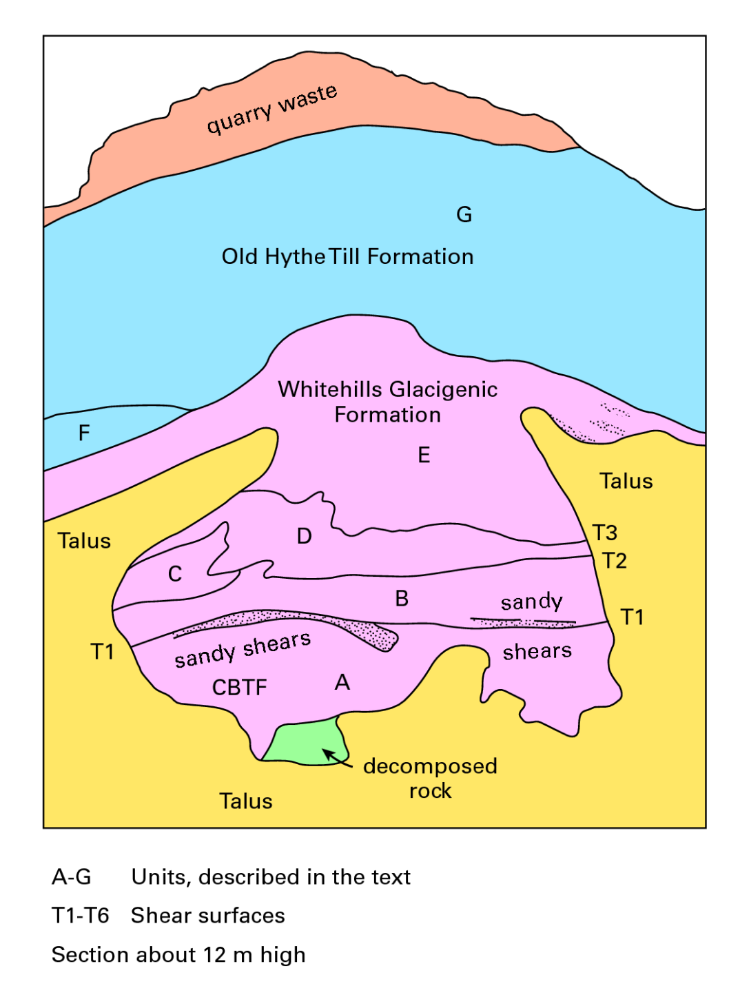

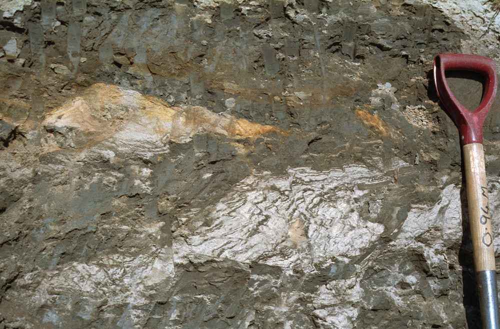
At locality 6, some 210 and 240 m from the north-eastern corner of the quarry, a 5 m-thick body of sand was recorded in June 1997. It lay above dark clay (unit E of locality 1) to reach the present-day soil over part of the exposure, wedging out at the northern end below the upper till of locality 1 (unit G). In October 1997, however, after the face had been taken back, it appeared to be entirely overlain by till of the Old Hythe Till Formation. Towards the northern end of the sand body, the boundary of the sand with the underlying dark clay (E) was folded by steep, almost vertically plunging folds, and the sand body itself frayed out northwards immediately below the Old Hythe Till Formation in a zone of shearing. At its southern end, the sand body merges into streaks and bands of sand within unit E, with complex folds and faults. These streaks and bands are locally crossed by numerous subhorizontal shears to give the appearance of brittle fracture cleavage (P104124). The faulting and shearing at the southern end of the sand body has also led to the occurrence of angular blocks of clay up to 20 cm across surrounded by sand, a feature that is also found farther south along the face near the south-western corner of the quarry. The upper part of the sand body locally retains trough cross-bedding in sets some 0.5 m thick, but the sedimentary structures are generally obscured or destroyed by small-scale normal and reversed faults and shears (including some conjugate systems), subhorizontal shears, and shears dipping 25° to 30° to the west or north-west (Peacock and Merritt, 2000b, fig.14).
Details of other localities sited on (P915304) are given in Peacock and Merritt (2000a) and Merritt et al. (2000).
Genesis and age
The clasts in the Craig of Boyne Till, including numerous gabbro erratics and well-rounded clasts of quartzite and psammite derived from outcrops of gabbro and Middle Old Red Sandstone a few kilometres west of the quarry, imply a former ice movement to the east or north-east. The weathering implies that the till probably predates an interglacial period, either the last (Ipswichian), or an older one.
The lithology of the Whitehills Glacigenic Formation suggests derivation particularly from Mesozoic strata that crop out on the floor of the Moray Firth (Andrews et al., 1990), as well as Quaternary marine deposits. This is supported by structural evidence for ice movement from a northerly direction, such as folds overturned to the south, and a number of shears dipping gently between north-east and north-west. North–south or south–north directed striae were seen by J D Peacock and F M Synge (unpublished) in 1971 on a ‘high’ of fresh bedrock where the basal weathered till was absent, and they probably relate to this ice movement. Amino-acid epimerisation ratios from hinges of Arctica islandica at Gardenstown and King Edward (Miller et al., 1987; Peacock and Merritt, 1997) suggest that the Whitehills Glacigenic Formation was emplaced after early OIS 3 (about 60–45 ka cal BP), possibly in the Late Devensian. The Whitehills Glacigenic Formation thus seems to have been emplaced by a glacier flowing eastwards along the Moray Firth (the Moray Firth glacier), with its southern flank extending south or south-east on to inland parts of coastal Banffshire.
The derivation of the Old Hythe Till based on its content of erratics is ambiguous since it includes material derived from seawards (shell fragments) as well as from the south (troctolite) and west or south-west (e.g. well-rounded pebbles of quartzite). It is suggested that the Old Hythe Till Formation at the Boyne Limestone Quarry was deposited by ‘inland’ ice that had been directed to flow south-eastwards by the still-active Moray Firth ice stream (Peacock and Merritt, 2000a).