Cainozoic geological history, north-east Scotland
| Merritt, J W, Auton, C A, Connell, E R, Hall, A M, and Peacock, J D. 2003. Cainozoic geology and landscape evolution of north-east Scotland. Memoir of the British Geological Survey, sheets 66E, 67, 76E, 77, 86E, 87W, 87E, 95, 96W, 96E and 97 (Scotland).
Contributors: J F Aitken, D F Ball, D Gould, J D Hansom, R Holmes, R M W Musson and M A Paul. |
Summary of Cainozoic geological history
Palaeogene and Neogene (formerly the Tertiary)
The geological record of this period of time on the mainland is largely one of landscape evolution by subaerial erosion and the development of deep weathering profiles. The Paleocene was marked by considerable volcanic activity along the western seaboard of Scotland. Uplift of as much as 1.5 km was associated with this event, causing an eastward tilting of peneplains formed across north-east Scotland during the Late Cretaceous and earlier. Cretaceous sediments in the developing Inner Moray Firth Basin and on the Buchan Plateau were exposed to erosion and many of the major valleys of the region were initiated as river systems. They became established on the tilted peneplains and drained towards the deepening Moray Firth and North Sea basins, where sedimentation was rapid. For example the chalk is overlain by a thick succession of Paleocene sandstone, mudstone and siltstone with beds of lignite, which crop out in the eastern North Sea basin (Gatliff et al., 1994). The kaolinitic flint and quartzite-rich deposits of the Buchan Gravels Formation preserved on isolated hilltops in central Buchan were laid down in the catchments of such rivers, their present position resulting from subsequent topographical inversion. A warm, humid climate prevailed until the late Miocene, during which time the effects of chemical weathering penetrated deeply below the land surface forming ‘clayey gruss’ saprolites. Mechanical weathering became increasingly intense during the Pliocene and early Pleistocene as the climate deteriorated and granular disintegration occurred, particularly of coarse-grained igneous rocks, to form ‘gruss’ saprolites. Subsequent glacial erosion has failed to remove these ancient regoliths over large areas of the district, and they locally extend to depths of 20 m or more.
In this volume ‘Tertiary’ is used as an informal term in contexts where it would be inappropriate to be more specific.
Quaternary (Pleistocene and Holocene)


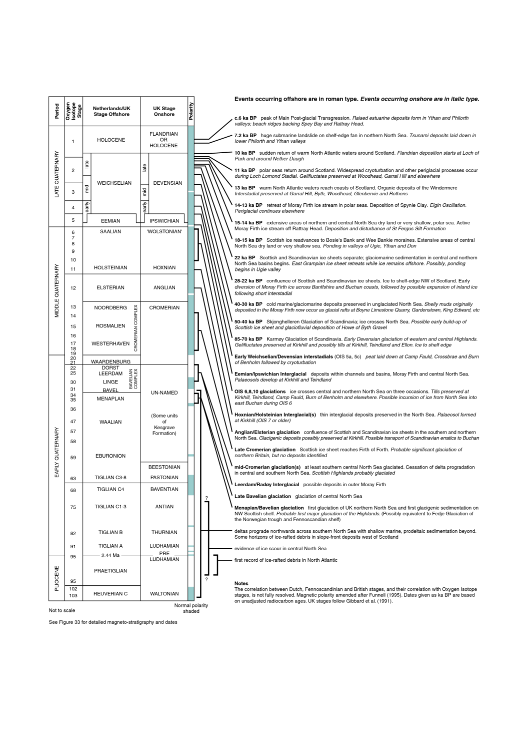
The history of the Pleistocene period is described fully in further articles, where both the onshore and offshore evidence is examined. The Scottish mainland has experienced numerous glacial episodes during the past two million years or so, but only the last glaciation, the Main Late Devensian, has left an appreciable sedimentary record (P915341). Despite over 150 years of research, the extent of this ice sheet in north-east Scotland remains controversial (P915250). Sparse pre-Devensian deposits representing stages back, possibly, to the Anglian occur locally, and many geomorphological features, such as some former glacial meltwater channels, have clearly evolved during several glacial episodes. The Quaternary succession is more complete offshore, where it thickens towards the axis of the North Sea basin.
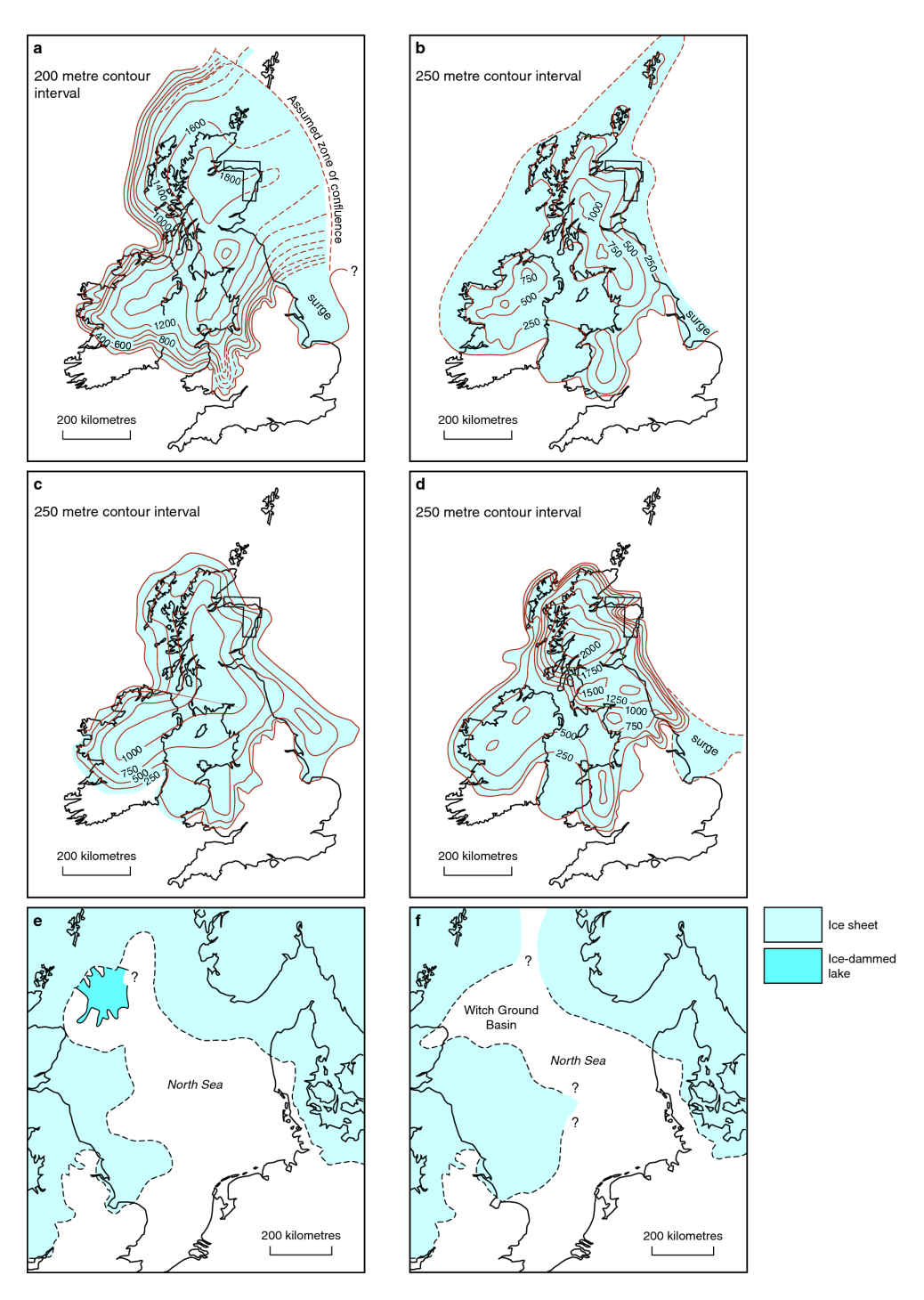
The Quaternary deposits and features of the district occur in four distinct geomorphological domains and can be related to five distinct ice masses that co-existed during the Late Devensian and earlier glaciations (P915251). The eastern Grampian Highlands were mainly affected by relatively sluggish ice that flowed outwards from centres of accumulation in the Cairngorms and Gaick. It deposited mainly thin, sandy diamictons in this domain, followed during deglaciation by meltwater deposits that are mainly confined to major valleys such as the Dee and Spey.
A northern domain was affected by a powerful ice stream that flowed out of the Moray Firth and impinged on the northern coast of the district. It typically laid down dark bluish grey diamictons containing abundant erratics and rafts of Mesozoic rocks and cold-water Quaternary sediments dredged up from the bed of the firth. Ice from the Spey merged with the Moray Firth ice stream to the west of Portsoy. An eastern domain was influenced by ice that flowed north-eastwards from Strathmore and was deflected back onshore to the north of Aberdeen where it left a distinctive suite of reddish brown sediments. These contain clasts of Permo–Triassic sandstone and dolomite and possible Mesozoic calcareous siltstone from the adjacent North Sea basin, in addition to material from the Old Red Sandstone and Devonian volcanic rocks of Strathmore. The deflection was probably caused by Scandinavian ice offshore. Red till is widespread in Strathmore itself, but is relatively thin, demonstrating that this third domain was mainly one of glacial erosion.
The fourth distinctive geomorphological domain is that of the Buchan Plateau. This area was once thought by some to be ‘moraineless’, but glacial deposits do occur, although they are thin and patchy (P915251). Features of glacial erosion are very poorly developed, but they do indicate that the final ice movement was from the west. This observation is supported by the presence of tills with erratics derived from the west, and by the pattern and distribution of glacial drainage channels across the area that indicate westwards retreat of the ice. However, an earlier, south-eastward movement of ice deposited dark bluish grey tills which occur sporadically at depth. The widespread presence of deeply weathered rock in central
Buchan coupled with the survival of the Buchan Gravels indicates that minimal glacial erosion has occurred there throughout the Quaternary period, probably as a consequence of the ice being sluggish and cold-based in this peripheral part of the mainland. Periglacial deposits and structures such as ice-wedge polygons are relatively common across the Buchan Plateau leading to the belief, now considered unlikely, that it was unglaciated at least during the whole of the Late Devensian.
Coastal glacigenic deposits commonly overlie tills derived from inland suggesting that the East Grampians ice had retreated from the coast prior to inundation by the Moray Firth and Strathmore ice streams (P915251). This view is supported by the presence, in the lower valleys of the Deveron, Ugie, Ythan and Don, of laminated glaciolacustrine deposits that locally interdigitate with the coastal tills, but which generally rest on tills derived from inland. The lakes were dammed by the coastal ice streams and, for some time, meltwaters ponded in the catchment of the Deveron may have flowed into that of the Ythan via a prominant glacial spillway between Turriff and Fyvie. In Strathmore, red deposits are widespread in the lower reaches of the Grampian valleys, but here there is local evidence that the East Grampian ice expanded after the Strathmore ice had begun to retreat.
The global lowering of sea level during the last glaciation brought about by the abstraction of water to form the continental and local ice sheets was more than offset in most of mainland Scotland by glacio-isostatic depression of the land caused by ice loading. As a result some glaciomarine sediments, laid down at the retreating ice margins, are now raised above sea level. The oldest of these sediments occur in the vicinity of the St Fergus gas terminal, near Peterhead, where they have been dated to around 15 000 BP (radiocarbon years before present). Glaciomarine clays near Elgin can be compared to the ‘Errol Beds’ of the Firth of Tay, which were laid down in arctic conditions while the main Late Devensian ice sheet retreated. The whole district was probably deglaciated by 13 000 BP. However, relative sea level continued to fall for several thousand years, leading to the incision of deep channels that are now buried at the mouths of major rivers like the Dee and Ythan.
Evidence of the relatively warm Windermere Interstadial (13 000–11 000 BP) is restricted to a few sites where buried organic deposits have been found, such as at Glenbervie, in Strathmore. No glaciers existed in the district during the subsequent Loch Lomond Stadial (11 000–10 000 BP), but many periglacial phenomena were formed during this very cold period. The climate warmed abruptly at the beginning of the Holocene epoch, the present interglacial stage. Intense erosion would have occurred initially on the bare ground before soils developed and vegetation became established. At first, braided rivers flowing across gravelly floodplains were common, but they later stabilised into the mainly single-thread and locally meandering streams of the present day. Relative sea level rose during the Main Postglacial Transgression of the mid-Holocene, peaking at a few metres above OD about 6000 years ago. This resulted in marine inundation of the lower reaches of river valleys and deposition of estuarine silt, sand and clay, commonly on terrestrial peats and fluvial sediment laid down earlier in the Holocene. There is evidence preserved near Fraserburgh and in the lower Ythan valley that at least one huge tidal wave (tsunami) hit the coast about 7000 years ago. It was generated by a massive submarine slide on the Norwegian continental margin.