Central complexes - introduction, Hebridean Igneous Province
| Emeleus, C H, and Bell, B R. 2005. British regional geology: The Palaeogene volcanic districts of Scotland. Fourth edition. Keyworth, Nottingham: British Geological Survey. |
Introduction


The Hebridean Igneous Province is one of the World's classic areas for the development of central complexes (P914119). Each central complex may contain many, or few, igneous rock types in intimate relationship with various metamorphic and sedimentary country rocks. The igneous rocks exhibit a variety of modes of intrusion and crop out within restricted, approximately circular areas, up to about 15 km in diameter. These represent the eroded roots of central volcanoes and, where reliable age data are available, individual central complexes generally appear to have been relatively short-lived. From initiation to decay, and subsequent Palaeogene unroofing, possibly took less than 1 Ma in some instances. Most of the central complexes contain clear evidence of surface volcanism at an early stage in their evolution, and extrusive igneous rocks are commonly preserved within them. Conversely, the associated and relatively young, coarse-grained intrusions cooled and crystallised slowly at some depth (probably from 2 to 3 km). The coarse-grained intrusions were most likely emplaced beneath an ever-growing volcanic superstructure (e.g. Skye, Rum, Mull), but some probably formed beneath a thick cover of country rocks and may not have experienced associated surface volcanism (e.g. the North Arran Granite Pluton).
The central complexes have been foci of intense, very localised magmatic activity dominated by basic and/or ultrabasic magmas derived from the Earth's upper mantle. These primitive magmas were usually accompanied by silicic magmas of mixed origin:
- those generated through partial melting of the continental crust as this was traversed by the basic magmas
- those originating by fractionation of the basic magmas as they ponded in the upper crust (Chapter 10)
Most of the central complexes are sited on ridges of pre-Mesozoic rocks, at the intersections of major north—south-trending lineaments with older cross-cutting (generally north-east—south-west) faults (P914121). The continental crust within the Hebridean Igneous Province is generally thinner than in adjoining areas (Meissner et al., 1986), which may have focussed the igneous activity (Thompson and Gibson, 1991). The surrounding country rocks comprise older Paleocene lava fields, as for example on Skye and Mull, and/or basement lithologies, for example Lewisian gneisses and Torridonian sedimentary rocks on Rum, Dalradian metasedimentary rocks plus younger sedimentary strata on Arran, and Moine psammites and pelites on Ardnamurchan. These basement lithologies are commonly overlain by attenuated basin-margin sequences of Triassic, Jurassic and Cretaceous strata.
The geometry of the intrusions depends on the lithologies involved, and five main associations are described below.
i Coarse-grained ultrabasic and basic rocks, such as peridotite, troctolite and gabbro, commonly form layered, relatively flat-lying sequences that may be several hundreds of metres thick, and possibly dip at a shallow angle towards a focal point at a few kilometres depth. Alternatively, these rocks may form sets of concentric conical intrusions (cone-sheets) with a focal point at depth (see below). Ring-dyke intrusion models that were previously invoked to explain the arcuate plan of certain large basic intrusions (e.g. Bailey et al., 1924; Richey, 1932) are not now considered to be valid for a number of reasons. In particular, the central 'block' would have to drop to unrealistic depths along steeply inclined, outwardly dipping fractures in order to create the space necessary for intrusions that commonly have ring widths in excess of 1 km.
ii Fine-grained basic rocks, for example dolerite and basalt, occur in sets of cone-sheets and other sheet-like intrusions emplaced into older coarse-grained ultrabasic and basic intrusions and the adjoining country rocks; they are related to dyke emplacement during growth of the central complexes (see below).
iii Intermediate, hybrid and granitic rocks typically occur in nested plutons comprising small, stock-like intrusions, usually with steep-sided, outwardly inclined margins, which are for the most part younger towards the core of the intrusive centre. Narrow ring-dykes, commonly of mixed-magma composition (basic to silicic), may also be present.
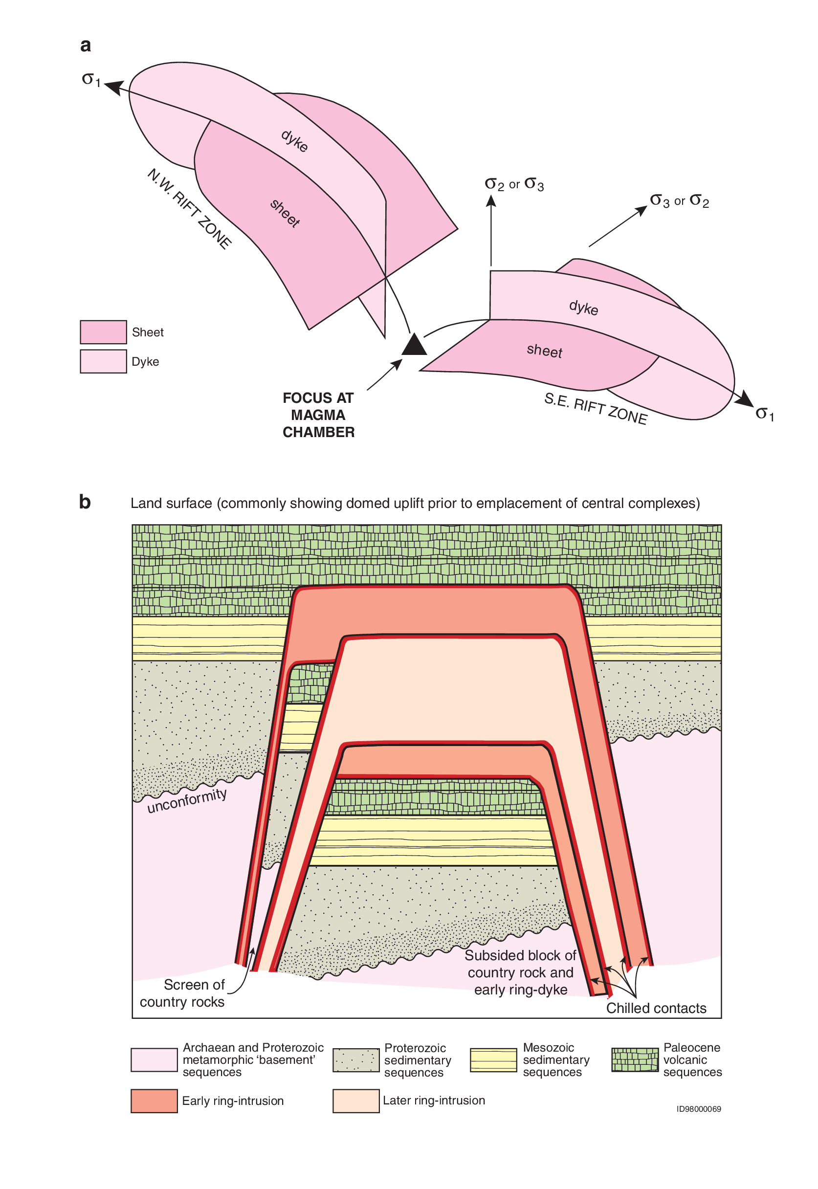
iv Cone-sheet emplacement and its relationship with the linear dyke swarms have been examined by Walker (1975b, 1993b). Sets of cone-sheets comprising basalt or dolerite form conical intrusions, each typically less than 5 m thick, with a common focal point at depth. They are generally more numerous in two opposing quadrants of the central complex, for example north-west and south-east, and are related to a dyke swarm that, in this example, would trend north-west—south-east (P914136a). Thus, the central complex appears to have acted as a focal point for cone-sheet and dyke emplacement. Detailed mapping of the cone-sheets and dykes indicates that the emplacement of both sets of intrusions overlaps in time and space. Where crustal dilation is slow, then magma excursions cannot be accommodated as dykes, but rather will be emplaced as cone-sheets. Intrusion of sets of cone-sheets can cause vertical thickening and uplift of the volcanic edifice by as much as 1500 m (e.g. Le Bas, 1971), similar to the amount of horizontal crustal dilation resulting from the intrusion of some dyke swarms.
v Ring-dyke emplacement occurs when typically silicic magma is intruded along steep, outwardly dipping fractures resulting from the subsidence of a central, cylinder-like block. The fractures may either reach the Earth's surface, forming a caldera and initiating surface volcanism, or be truncated along a subsurface, planar and essentially horizontal fracture, resulting in a cauldron subsidence and little or no surface volcanism (P914136b). Associated with the central subsidence process, the silicic magmas may create space by stoping and by gas brecciation during their ascent. Ring-dykes commonly occur in nested sets with complicated intrusive relationships, as exemplified by the Mull Central Complex (e.g. Richey, 1932).
Evidence for surface volcanic activity during the development of the central complexes takes the form of volcaniclastic materials (tuffs, agglomerates, breccias etc) and lavas, covering a wide range in composition, that are commonly caught up as screens between younger intrusions. The amount of such evidence varies, but this may simply reflect the relative level of erosion. For example, at the present day, the rocks exposed in the Central Arran Ring complex are predominantly lavas and volcaniclastic rocks with minor amounts of gabbro, granite and other coarse-grained rocks, but it is likely that with further erosion these proportions would be reversed and eventually the volcanic rocks would be removed. Surface venting would appear to have been more common during the earlier stages of development of individual complexes.
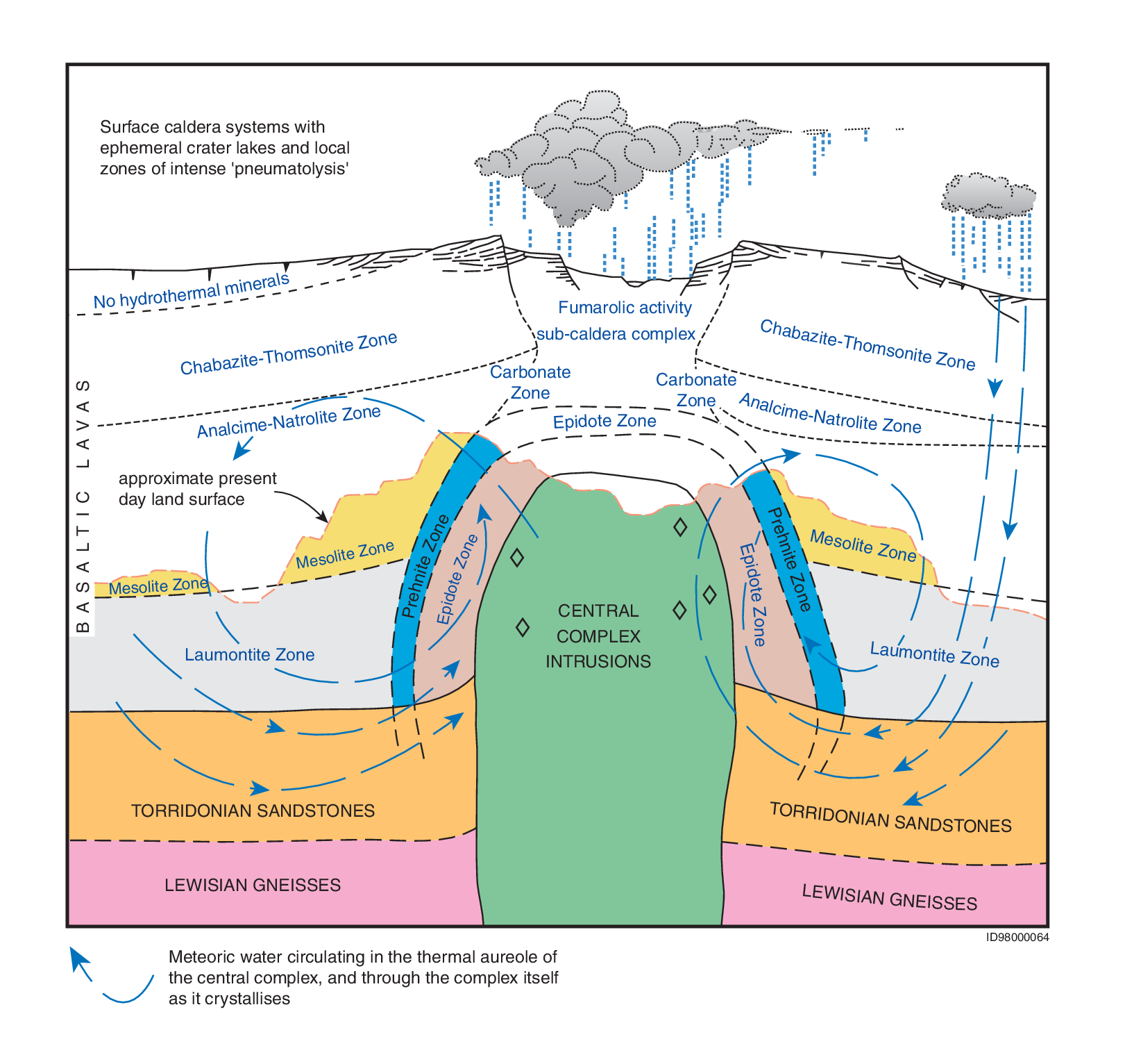
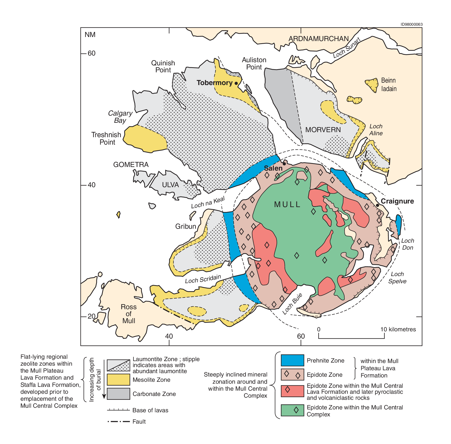
Intrusion of magma into the upper, water-saturated crust resulted in the development of convecting hydrothermal systems that circulated meteoric water through both the intrusions and the adjacent country rock (P914131). This resulted in pervasive low-grade alteration that is estimated to have taken place at about 400°C, and caused alteration of the mafic minerals generating 'serpentine' from olivine, amphibole and chlorite from pyroxene and biotite. Alteration of silicic minerals resulted in turbidity and clay-mineral formation in feldspars, and fluid inclusion development in quartz. When fluid flow was concentrated along channels, secondary precipitation of minerals such as chlorite, epidote, prehnite and carbonate occurred in the myriad of tensile fractures that developed in reponse to both cooling of the intrusions and fracture by fluid ingress. The heated meteoric waters also imparted distinctive stable isotopic signatures to the altered rocks; these are useful in determining the origin of the water and in tracing the circulation patterns (e.g. Taylor and Forester, 1971; Forester and Taylor, 1976, 1977). The pervasive alteration haloes extend laterally for as much as 20 km from the margins of the central complexes, as on Mull, but the most intense alteration that was caused by temperatures in excess of 800°C is restricted to a zone less than 1 km in width (P914146). The mineral-filled fractures are more localised, either within the central complexes or in narrow zones in the surrounding country rocks that are commonly north-west-trending, parallel to the regional dyke swarms. Within the lava piles intruded by the Mull and Skye central complexes, the narrow concentric zones of secondary mineral growth that are attributed to the emplacement of the central complexes are superimposed on flat-lying zeolite and other mineral zoning that resulted from burial metamorphism of the lavas (Walker, 1971; P914130; P914131). The pervasive alteration of rocks in and surrounding the central complexes by circulating hydrothermal systems is a potential source of change to the rock chemistry and careful sampling is necessary when fresh material is required for geochemical and isotopic studies (e.g. Pankhurst et al., 1978; Walsh et al., 1979; Dickin and Exley, 1981).
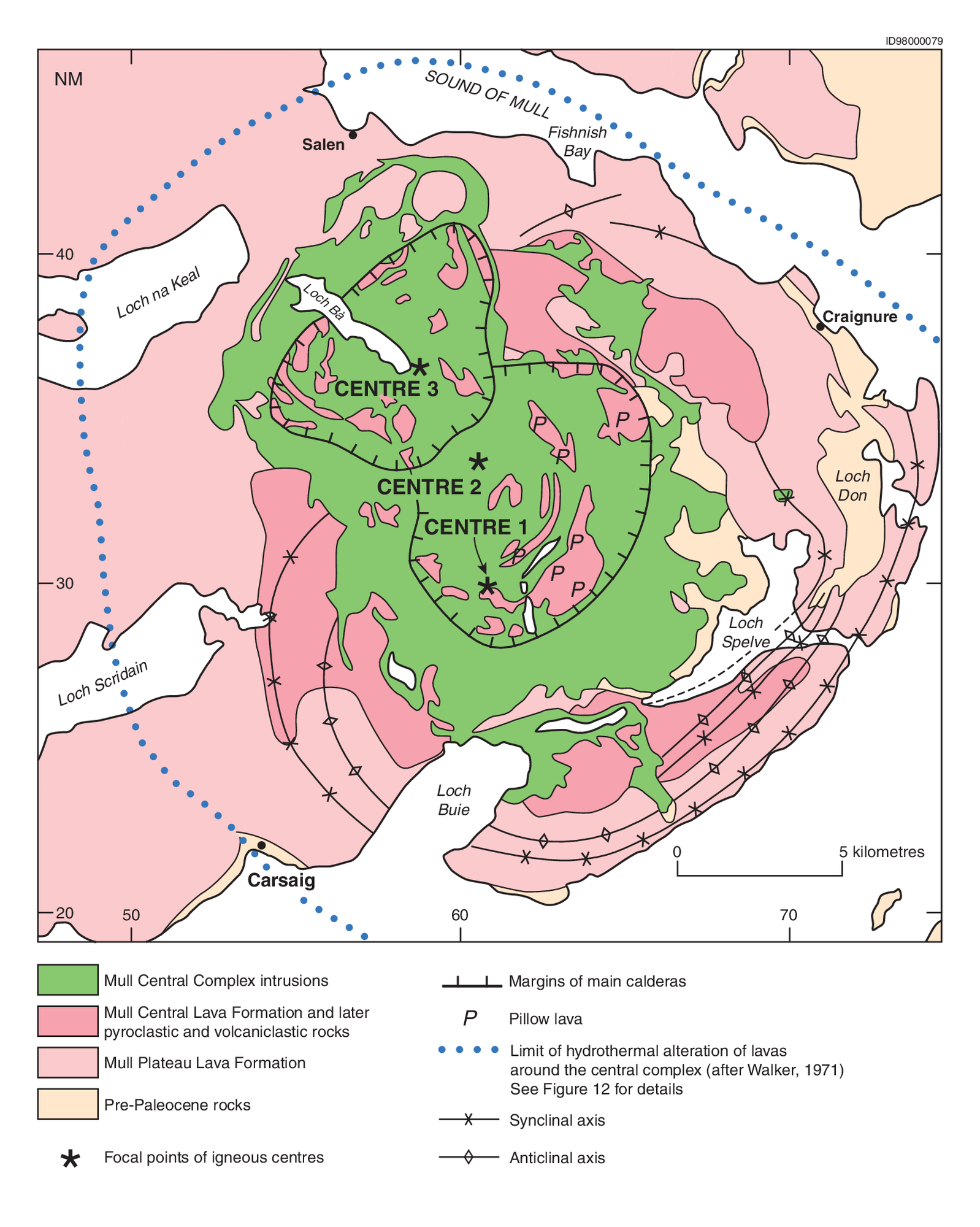
The deformation of the surrounding country rocks during emplacement, and possibly as a consequence of central uplift and gravitational collapse, has led to the development of spectacular annular folds (both anticlines and synclines), which extend outwards for distances of up to 5 km from the central complexes and produce significant upper crustal shortening (Chapter 11). The most complete example occurs around the margin of the Mull Central Complex, where folding of pre-Palaeozoic country rocks may have commenced even prior to the eruption of the Mull Lava Group, which itself predated the central complex (Walker, 1975a). Within the area of the central complex, the lavas rest on metasedimentary basement rocks of the Moine Supergroup or on Triassic sedimentary rocks. In contrast, at the margins of the updomed area, they overlie Jurassic and Cretaceous sedimentary rocks.
Central uplift of several hundreds of metres occurred during emplacement of the layered ultrabasic and basic units and the predominantly basic cone-sheet sets, for example on Skye and Mull. This uplift may have been very rapid and possibly led to very early unroofing of some of the complexes, for example on Rum. Emplacement of granites also caused central uplift, as in north Arran, where there are steep-sided domes. However, where fracture systems penetrated to the contemporaneous land surface, as on Rum, emplacement of silicic magmas was commonly accompanied by central subsidence, with caldera formation and associated volcanic eruptions. Central collapse, possibly by several hundreds of metres, would have accompanied the emplacement of ring-dykes such as at Loch Bà on Mull, at Marsco in the Western Red Hills Centre of Skye, and the mixed-magma ring-dyke of Centre 2, Ardnamurchan, but these examples do not preserve direct evidence of associated volcanicity.
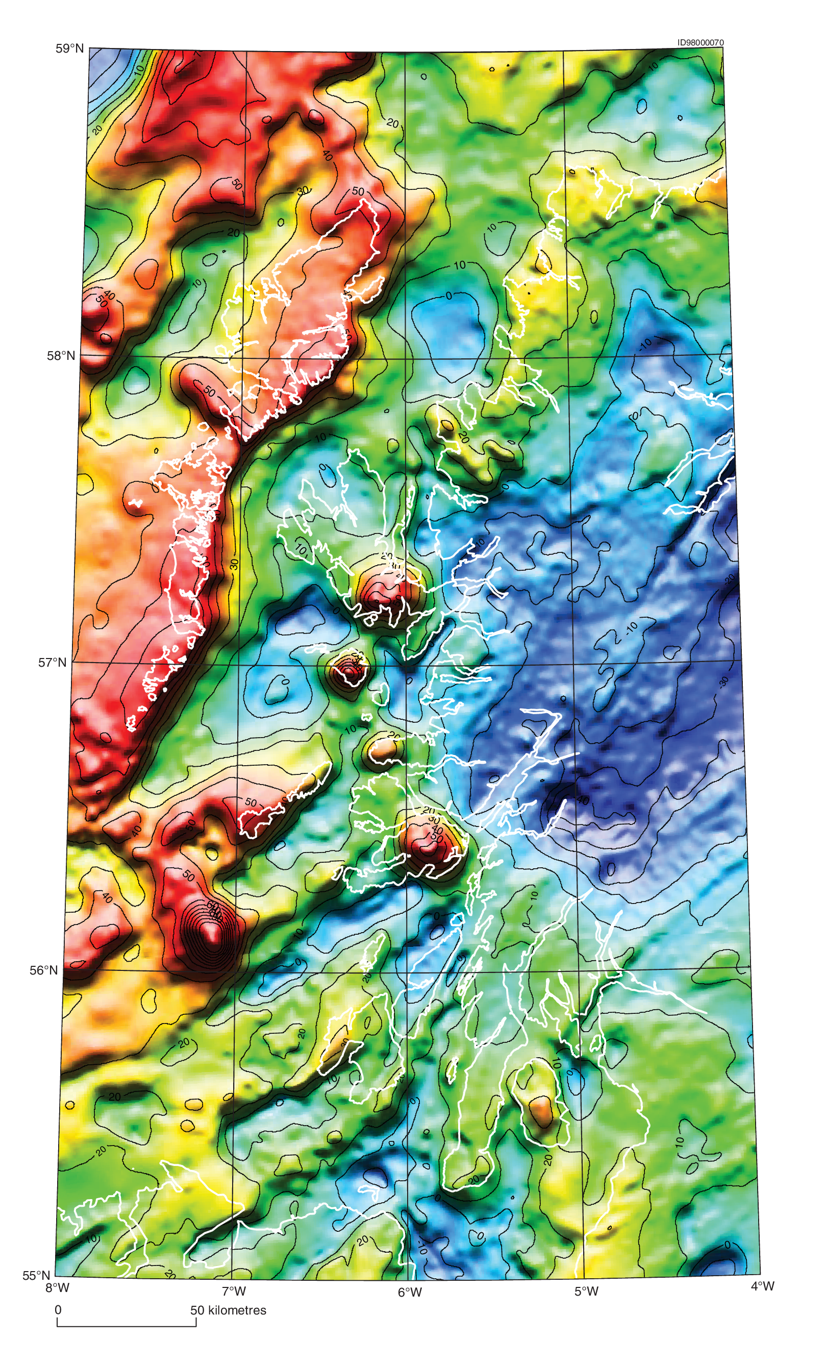
Gravity and magnetic anomalies are associated with the central complexes. All of the complexes are characterised by positive Bouguer gravity anomalies which are generally large, very localised and characterised by steep gradients (P914137). The anomalies are attributed to the presence of steep-sided bodies of dense rock, such as gabbro or peridotite, extending to depths of 15 km or more (McQuillin and Tuson, 1963; Bott and Tuson, 1973; but see also Emeleus et al., 1996b). Based upon these geophysical data, it is inferred that where granites dominate the present-day surface outcrop, they are thin and do not extend to depth. For example, on Mull, Bott and Tantrigoda (1987) estimated that granitic rocks form as little as 10 per cent by volume of the entire complex and are less than 2 km thick. Supporting evidence comes from seismic investigations carried out over the Western Red Hills Centre on Skye, where it is inferred that the granites are about 2 km thick and overlie interleaved basic and silicic sheets lying at depths of between 2100 and 2400 m (Goulty et al., 1992). The strong, comparatively localised magnetic anomalies over the complexes probably reflect the predominance of gabbroic rocks; such magnetic anomalies are due to the presence of high modal amounts of iron-titanium oxides, which are generally only sparsely present in rocks more primitive than gabbro (e.g. peridotite and troctolite).
Some 25 other igneous centres or central complexes have been identified throughout the continental shelf north and west of the Outer Hebrides from geophysical surveys (P914120). Some are exposed on the sea bed and have been sampled, but others are concealed by younger strata. Their features are summarised by Fyfe et al. (1993) and by Stoker et al. (1993).
The onshore complexes, numbered I to VIII in Figure1, are described from north to south. Complexes IX to XI, Slieve Gullion, the Mourne Mountains and Carlingford are not included in this district, but the submerged Blackstones Bank is described.