Uploads by Ajhil
Jump to navigation
Jump to search
This special page shows all uploaded files.
| Date | Name | Thumbnail | Size | Description | Versions |
|---|---|---|---|---|---|
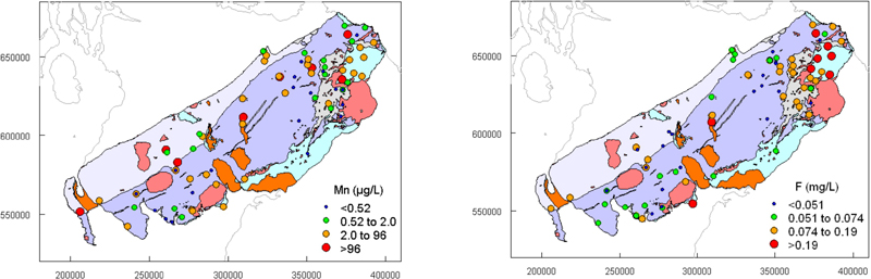
| 11:17, 24 June 2026 | Manganese concentrations in groundwater.jpg (file) |  |
25 KB | 1 | |
| 11:15, 24 June 2026 | Bedrock aquifer units1.jpg (file) |  |
58 KB | 1 | |
| 10:44, 24 June 2026 | Mn concentrations in Scotland.jpg (file) |  |
41 KB | 1 | |
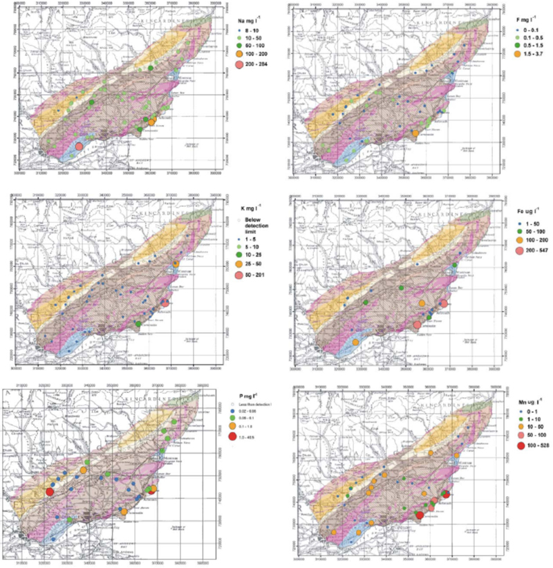
| 10:34, 24 June 2026 | Maps2.jpg (file) |  |
411 KB | 1 | |
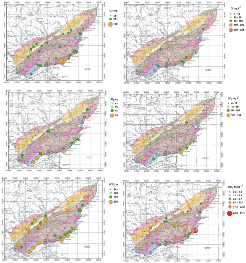
| 10:33, 24 June 2026 | Maps.jpg (file) |  |
439 KB | 1 | |
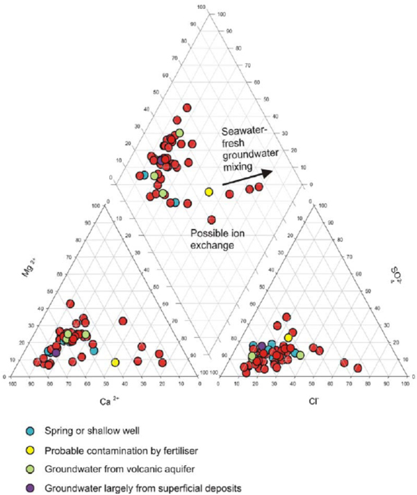
| 10:32, 24 June 2026 | Piperdiagram majorions1.jpg (file) |  |
141 KB | 1 | |
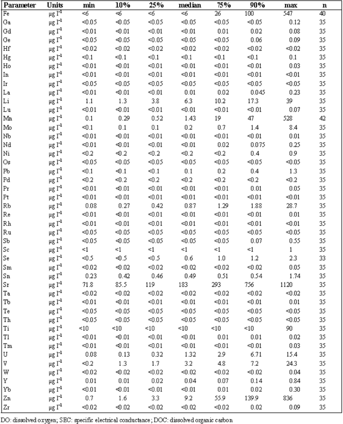
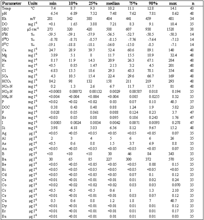
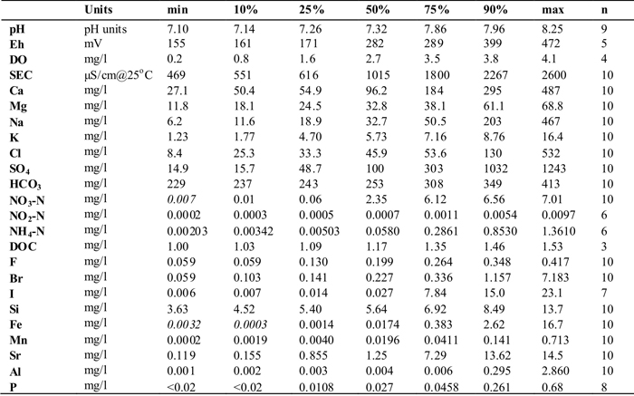
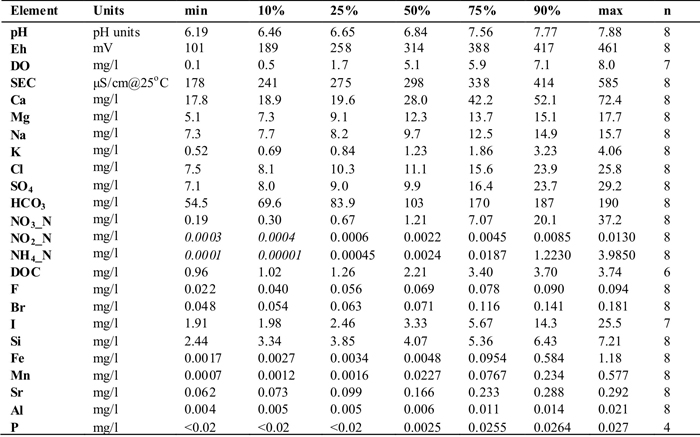
| 10:31, 24 June 2026 | Tablestats summary2.jpg (file) |  |
230 KB | 1 | |
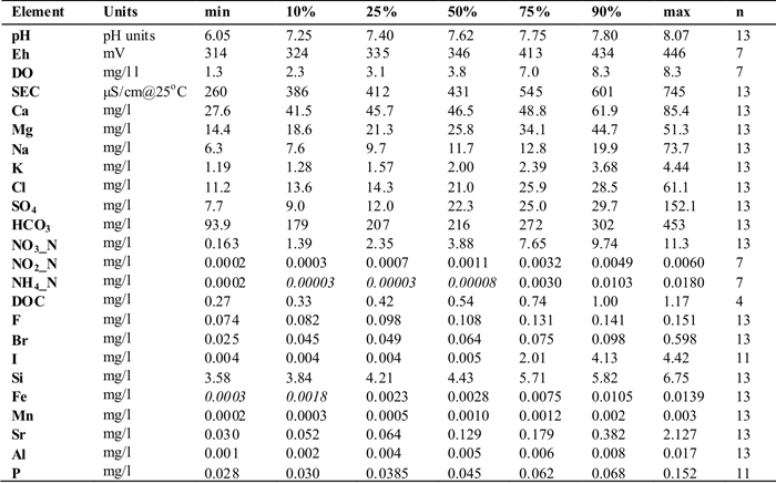
| 10:31, 24 June 2026 | Tablestats summary1.jpg (file) |  |
198 KB | 1 | |
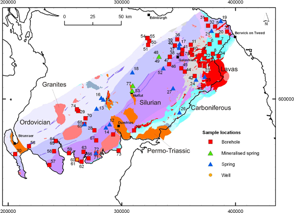
| 10:16, 24 June 2026 | Samples Strathmore.jpg (file) |  |
157 KB | 1 | |
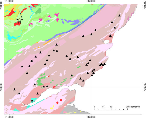
| 10:12, 24 June 2026 | SSmap5.jpg (file) |  |
133 KB | 1 | |
| 10:12, 24 June 2026 | SSmap4.jpg (file) |  |
134 KB | 1 | |
| 10:12, 24 June 2026 | SSmap3.jpg (file) |  |
138 KB | 1 | |
| 10:11, 24 June 2026 | SSmap2.jpg (file) |  |
136 KB | 1 | |
| 10:10, 24 June 2026 | SSmaps.jpg (file) |  |
139 KB | 1 | |
| 10:06, 24 June 2026 | Piper individual3.jpg (file) |  |
165 KB | 1 | |
| 10:05, 24 June 2026 | Summarytable carboniferous.jpg (file) |  |
127 KB | 1 | |
| 10:05, 24 June 2026 | Summarytable devonian.jpg (file) |  |
129 KB | 1 | |
| 10:04, 24 June 2026 | Summarytable ordovician.jpg (file) |  |
125 KB | 1 | |
| 10:04, 24 June 2026 | Summarytable silurian.jpg (file) |  |
130 KB | 1 | |
| 09:50, 24 June 2026 | Samples southernScotland1.jpg (file) |  |
149 KB | 1 | |
| 09:48, 24 June 2026 | Samples southernScotland.jpg (file) |  |
149 KB | 1 | |
| 14:22, 17 June 2026 | Bedrock aquifer units.jpg (file) |  |
58 KB | 1 | |
| 14:21, 17 June 2026 | Manganese concentrations.jpg (file) |  |
25 KB | 1 | |
| 14:21, 17 June 2026 | MnConcentrations.jpg (file) |  |
41 KB | 1 | |
| 13:37, 17 June 2026 | PH HCO3 (3).jpg (file) | .jpg) |
51 KB | 1 | |
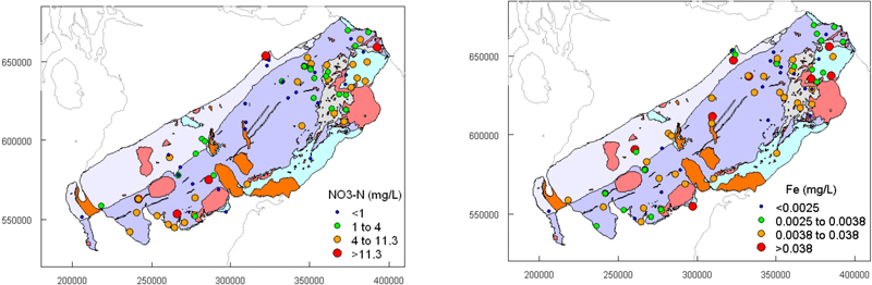
| 13:36, 17 June 2026 | TON Fe.jpg (file) |  |
53 KB | 1 | |
| 13:36, 17 June 2026 | Cl SO4 (1).jpg (file) | .jpg) |
50 KB | 1 | |
| 13:36, 17 June 2026 | Ca Mg (2).jpg (file) | .jpg) |
50 KB | 1 | |
| 13:36, 17 June 2026 | Na K (2).jpg (file) | .jpg) |
50 KB | 1 | |
| 13:35, 17 June 2026 | PH HCO3 (2).jpg (file) | .jpg) |
51 KB | 1 | |
| 13:28, 17 June 2026 | Piperplot (1).jpg (file) | .jpg) |
25 KB | 1 | |
| 13:27, 17 June 2026 | UpperOldRedSST.jpg (file) |  |
82 KB | 1 | |
| 13:27, 17 June 2026 | MiddleOldRedSST.jpg (file) |  |
72 KB | 1 | |
| 13:27, 17 June 2026 | LowerOldRedSST.jpg (file) |  |
59 KB | 1 | |
| 13:17, 17 June 2026 | Samplingpts Morayshire (1).jpg (file) | .jpg) |
156 KB | 1 | |
| 13:16, 17 June 2026 | Samplinglocationmap (1).jpg (file) | .jpg) |
31 KB | 1 | |
| 13:11, 17 June 2026 | Samplingpts Morayshire.jpg (file) |  |
148 KB | 1 | |
| 13:06, 17 June 2026 | Mn F (1).jpg (file) | .jpg) |
42 KB | 1 | |
| 13:06, 17 June 2026 | NO3-N Fe (1).jpg (file) | .jpg) |
42 KB | 1 | |
| 13:05, 17 June 2026 | Cl SO4.jpg (file) |  |
43 KB | 1 | |
| 13:05, 17 June 2026 | Ca Mg (1).jpg (file) | .jpg) |
43 KB | 1 | |
| 13:05, 17 June 2026 | Na K (1).jpg (file) | .jpg) |
42 KB | 1 | |
| 13:04, 17 June 2026 | PH HCO3 (1).jpg (file) | .jpg) |
42 KB | 1 | |
| 12:53, 17 June 2026 | Piper1.jpg (file) |  |
30 KB | 1 | |
| 12:52, 17 June 2026 | StrathclydeGroup1.jpg (file) |  |
81 KB | 1 | |
| 12:51, 17 June 2026 | InverclydeGroup.jpg (file) |  |
72 KB | 1 | |
| 12:51, 17 June 2026 | ClackmannanGroup.jpg (file) |  |
62 KB | 1 | |
| 12:51, 17 June 2026 | CoalMeasures.jpg (file) |  |
74 KB | 1 | |
| 12:29, 17 June 2026 | Samplinglocationmap.jpg (file) |  |
385 KB | 1 | |
| 12:22, 17 June 2026 | Mn F2.jpg (file) |  |
75 KB | 1 |