The area around the Old Manse at Kilchrist, Skye - an excursion
| From: Bell, B.R. and Harris, J.W. An excursion guide to the geology of the Isle of Skye : Geological Society of Glasgow, 1986. © 1986 B.R. Bell & J.W. Harris. All rights reserved. October 2022 note: A new edition of the guide is now available. |

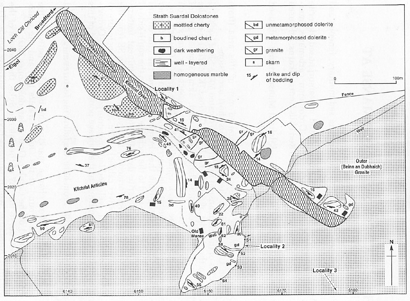
Excursion 6 The area around the Old Manse at Kilchrist (Figure 20) (modified from Nicholson 1985)
Purpose: A general excursion to examine sedimentary, igneous and metamorphic rocks.
Aspects covered: unmetamorphosed and metamorphosed dolerite dykes; folded, metamorphosed Cambro-Ordovician carbonates (marbles); the Outer Granite of the Eastern Red Hills Centre; skarns; a disused marble quarry.
Route: Cill Chriosd Churchyard–Kilchrist Manse (ruins)–disused marble quarry–(Cill Chriosd Churchyard).
Distance: 2 kilometres.
Time: 2–3 hours.
General comments: An excellent, detailed map of this area (from Nicholson 1985) provides the basis for this short excursion.
The ruins of the old manse at Kilchrist are located 500m SE of Loch Cill Chriosd in the district of Strath. Loch Cill Chriosd (Kilchrist) is on the north side of the Broadford-Elgol (A881) road, 5km (3 miles) SW of Broadford. Parking for 6 cars, 3 mini-buses or 2 coaches is available on the south side of the road, opposite the Cill Chriosd Churchyard. Coaches may turn at the marble quarry at Torrin, 4km (2.5 miles) further west along the main road from the churchyard. From the churchyard walk 500m SW along the road to the lochside where, on the south side of the road, a 30m-thick dolerite dyke (9B) forms a prominent feature. Proceed SE along the ridge formed by the dyke, noting 50m SE from the road (beneath electric power cables) a 75m-long, elongate enclosure of relatively undisturbed, well-bedded, metamorphosed Cambro-Ordovician dolostone (2D). Continue to the vantage point of the SE end of this part of the intrusion.
Locality 1 [NG 6154 2030]
From here, the following features may be noted and examined:
- A distinct vegetation change marking the boundary between the heather-covered ground of the Outer Granite (7F) and the grass-covered ground of the Cambro-Ordovician dolostones (2D)
- In the dolostone, to the SW of the dolerite dyke, the closure of the Kilchrist Anticline, which plunges ENE at a shallow angle. The deformation events associated with this structure pre-date the intrusion of the dolerite dyke. Furthermore, the marbles show an even earlier deformation episode in the form of boudinaged calcsilicate layers in the hinge of the anticline
- An apophysis of the dolerite dyke, trending ESE, terminating just before the fence. Also visible from this vantage point, on the higher ground further to the SE and within the Outer Granite, are spoil heaps associated with the formerly-worked dolostone (marble) quarries (see Locality 3, below). Proceed SE onto the continuation of the dolerite dyke and note on the SW side of the intrusion the following two features:
- 1–2mm-wide veins of buff-coloured, coarse-grained -granite, terminating in the marble
- A small anticline, plunging to the west, within the Cambro-Ordovician dolostones. Continue SE along the dolerite dyke to the granite-dolostone contact where it is cut and veined by the granite.
Locality 2 [NG 6164 2012]
Along this distinctive boundary skarns are intermittently developed (7I). Four are recognised and all are magnetite-dominated. Also present are two deformed, metamorphosed dolerite dykes which are truncated by the younger Outer Granite (7F). The skarns are located:
- (S1). SSW of a small waterfall
- (S2). Enclosed within the granite, SW of a deformed, metamorphosed dolerite dyke which contains secondary amphibole
- (S3). 2m SW of a poorly fenced-off, water-filled shaft. This skarn contains obvious malachite. Rock-debris in the vicinity of this skarn provides good samples without recourse to damaging the relatively limited outcrop
- (S4). Within a small recess below a soil bank. Also present within the marginal 10–20cm of the granite is a distinctly speckled, alkali pyroxenebearing facies. These alkali-rich pyroxenes have developed as a result of Al removal from the granitic magma during crystallisation (7F, 71)
Proceed SE across the granite for 300m to the spoil heaps of a small, disused marble quarry.
Locality 3 [NG 6184 1980]
SE of the spoil heaps is the quarry. The south face of the quarry is marked by a vertical contact of the granite and the enclosure of marble. Within the granite alkali-rich pyroxenes may be observed close to the contact. However, unlike those seen at (S4) of Locality 2, the first 4–5cm of the granite is depleted in mafic minerals, before giving way to a concentrated zone of the dark, alkali-rich pyroxenes. The marble was rich in forsterite, now hydrated to serpentine, and the rock has a distinctive yellow-green coloration. Dark aggregates of brucite, after original (metamorphic) periclase, are also common. The original dolostone was chert-bearing and on the NE side of the quarry prominent boulders containing chert nodules can be examined (particularly on weathered surfaces). During the thermal metamorphism concentric zones of secondary metamorphic minerals developed at the chert-dolostone boundaries and, in consequence, the rock has a prominent 'spheroidal' appearance. Further aspects of the metamorphism of the dolostones are presented in Section (7I) of Chapter 7.
Proceed back to the old manse at Kilchrist and thence to the BroadfordElgol (A881) road and to the Cill Chriosd Churchyard.
References
Appendix 1: Glossary of petrological names and terms
Appendix 2: Glossary of fossil names
Appendix 3: Glossary of place names and grid references
| At all times follow: The Scottish Access Codeand Code of conduct for geological field work |