West Trotternish, Skye - an excursion
| From: Bell, B.R. and Harris, J.W. An excursion guide to the geology of the Isle of Skye : Geological Society of Glasgow, 1986. © 1986 B.R. Bell & J.W. Harris. All rights reserved. October 2022 note: A new edition of the guide is now available. |


Excursion 22 West Trotternish (Figure 35a), (Figure 35b), (Figure 35c)
Purpose: To investigate the relationship between Jurassic sedimentary rocks and the Lower Tertiary sill complex of north Skye. Also, to examine the variations in composition of a banded, ultrabasic dyke.
Aspects covered: a banded, ultrabasic dyke; unlayered and layered, basic and ultrabasic sills; Middle Jurassic sedimentary rocks; rafts of sedimentary material (buchites) within a layered, basic sill.
Route:
- Kilmuir–Bornesketaig–north side of Camas Mor–Ru Bornesketaig–(Bornesketaig)
- Duntulm–Cairidh Ghlumaig–Port Duntulm (Duntulm)
Distance:
- 2 kilometres
- 2 kilometres
Time:
- 2 hours
- 4 hours
General comments: This excursion is presented assuming that the party is travelling north via Uig. Parts (i) and (ii) should be reversed if travelling via Staffin. Coastal exposures are involved and, therefore, low tide conditions are necessary. This excursion involves localities close to the road-side and the two parts can be undertaken separately if desired.
This excursion is split into two parts:
- A picrite sill intruded by a banded, ultrabasic dyke at Kilmuir
- Middle Jurassic sedimentary rocks intruded by a layered, basic sill at Duntulm
(i) A picrite sill intruded by a banded, ultrabasic dyke at Kilmuir
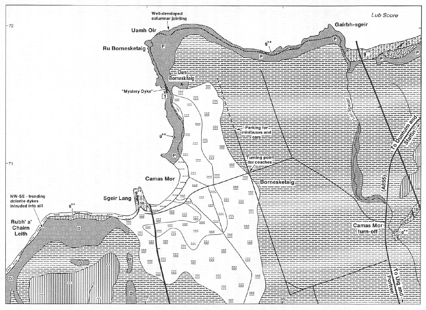
Kilmuir is located in west Trotternish, on the main (A855) coastal road, 32km (20 miles) from Portree via Uig, and 45km (28 miles) from Portree via Staffin. At Kilmuir, follow the minor road signposting Camas Mor for 1.2km (0.8 miles), past a prominent, ruined church on the SW side of the road, to a cross-roads. Coach parties should alight at this point, as this is the only convenient turning area for a coach. Car and minibus parties should proceed right (north) from the cross-roads for 350m to where parking for 4 cars or 3 minibuses is available at the end of the metalled road. From here, all parties should continue north along the unmetalled part of the road, for a further 400m, to its end. Go through the gate and proceed WSW along the wall and fence boundary, skirting the south side of Dun Bornaskitaig, to a small pebble beach.
Locality 1 [NG 3716 7154]
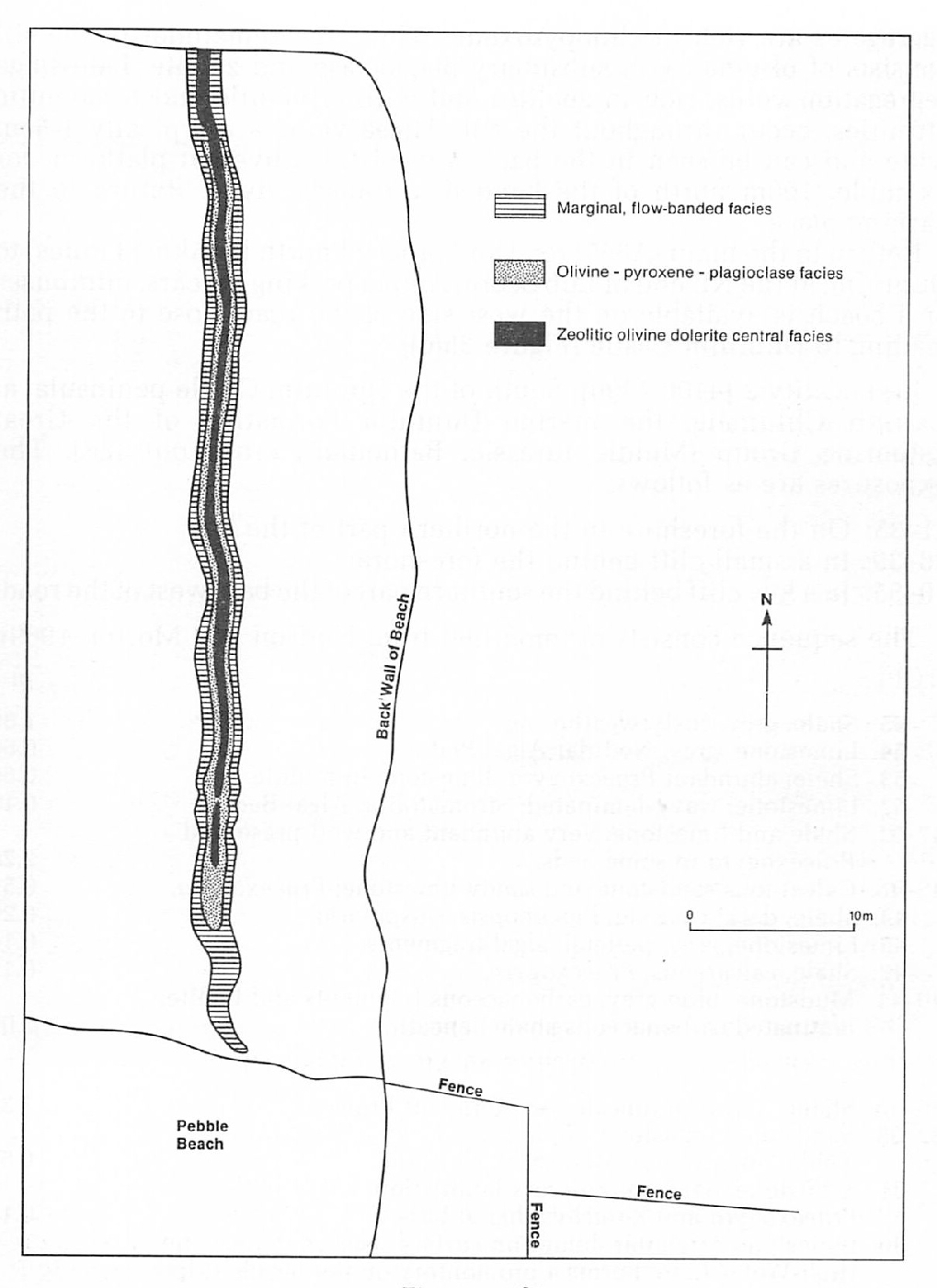
The rocks which crop out north and south of this beach form a wave-cut platform and are part of a picrite sill (9H) (Figure 35a). On the north side of the pebble beach a N-S -trending, banded, ultrabasic dyke crops out (9H). This minor intrusion was first described by Dreyer (1969) and can be followed for 55m, to where it disappears into the back wall of the beach. The rock-types within the dyke are shown in (Figure 35b). The following features should be noted:
- The margins of the dyke are composed of alternating bands of fresh dendritic olivine and augite (occasionally plagioclase)
- Plagioclase is typically interstitial to the olivine and augite and oriented perpendicular to these two minerals
- Zeolitised olivine dolerite forms the central facies of the dyke
- Fluxion (flow) banding is common close to the margins of the dyke
- Marginal, chill fades of the dyke are locally developed
The olivine dendrites (a, above) may be observed readily on fresh, as well as weathered, surfaces and appear as linear, parallel growths less than 1mm apart and over 10cm long (in places). The zeolite-rich centre of the dyke (c, above) is typically inweathered and can be traced from approximately 10–15m north of the pebble beach, to where the dyke disappears below the back wall of the beach. The banding (d, above) is particularly obvious on weathered surfaces 5m north of the pebble beach, where the dyke is distinctly non-linear. Proceed north along the wave-cut platform over the columnar-jointed picrite sill, towards Ru Bornesketaig. Within the sill-rock, occasional outweathered crystal aggregates are rich in clinopyroxene, whilst the remainder of the sill consists of olivine, with subsidiary plagioclase and zeolite. Late-stage segregation veins, rich in zeolites and with crinanitic and teschenitic affinities, occur throughout the sill. These veins are typically 1–5cm wide and can be seen in the back wall of the wave-cut platform, for example, 100m north of the banded, ultrabasic dyke. Return to the parking place.
Return to the main (A855) road and proceed north for 5km (3 miles) to Duntulm, at the NE end of Lub Score. Ample parking for cars, minibuses or a coach is available on the west side of the road close to the path leading to Duntulm Castle (Figure 35c).
(ii) Middle Jurassic sedimentary rocks intruded by a layered, basic sill at Duntulm
Locality 2 [NG 4100 7390]
South of the Duntulm Castle peninsula, at Cairidh Gh umaig, the marine Duntulm Formation of the Great Estuarine Group (Middle Jurassic, Bathonian) crops out (2F). The exposures are as follows:
| m | |
| 1–35: On the foreshore in the northern part of the bay | |
| 36–39: In a small cliff behind the foreshore | |
| 40–55: In a low cliff behind the southern part of the bay, west of the road | |
| The sequence consists of (modified from Hudson and Morton 1969): (TOP) | |
| 55. Shale, grey, rusty-weathering | 1.80 |
| 54. Limestone, grey; Nodular Algal Bed | 0.60 |
| 53. Shale, abundant Praeexogyra; limestone in middle | 0.60 |
| 52. Limestone, wavy-laminated; Stromatolitic Algal Bed | 0.15 |
| 47–51. Shale and limestone; very abundant and well-preserved Praeexogyra in some beds | 2.20 |
| 45–46. Calcareous sandstone and sandy limestone; Praeexogyra | 0.53 |
| 44. Shale, dark; Corbula, Placunopsis, Cuspidaria | 0.20 |
| 43. Limestone, grey, pelletal; algal fragments | 0.10 |
| 42. Shale, calcareous; Praeexogyra | 0.13 |
| 40–41. Mudstone, blue-grey; carbonaceous fragments and lignite; laminated carbonaceous shale beneath | 2.00 |
| (GAP IN EXPOSURE; FEW METRES AT MOST MISSING) | |
| 36–39. Shales and thin limestones; abundant Praeexogyra | 3.25 |
| 32–35. Sandstone, limestone, shale partings. Praeexogyra, Thalassinoides burrows, shark fin-spine | 0.50 |
| 31. Sandstone, dark, micro-cross-lamination. Layer with Praeexogyra and Kallirhynchia at base | 0.10 |
| 30. Limestone, irregular domes on surface, best seen near the High-Water Line. Forms a promontory on the beach at low tide | 0.20 |
| 24–29. Sandstones, partly calcareous, intensely burrowed in part, with shale partings; Praeexogyra and Kallirhynchia | 1.25 |
| 23. Siltstone, micro-cross-lamination; Praeexogyra, Kallirhynchia, Myopholas, Corbula and Modiolus | 0.15 |
| 22. Shale, smooth, dark; Myopholas, Corbula abundant; also Cuspidaria, heterodonts. | 0.60 |
| 21. Shale; Praeexogyra abundant | 0.15 |
| 20. Limestone, irregular domes on surface; Nodular Algal Bed | 0.15 |
| 10–19. Shale, calcareous sandstone and siltstone; Praeexogyra in some beds | 2.50 |
| 8–9. Shale, dark, pyritic; Placunopsis, Modiolus, Cuspidaria in upper part | 1.00 |
| POSITION OF OFF-SHOOT MINOR INTRUSION CROSSING SHORE, FROM DUNTULM CASTLE SILL | |
| 1–7. Siltstone and mudstone, Neomiodon. Exposed between offshoot dyke and main intrusion. These strata have been baked by the main sill. The contact between the sedimentary rocks and the sill is almost vertical | 4.00 |
| (BASE) |
Hudson and Morton (1969) interpret these rocks as having been deposited in a marine, though reduced salinity, environment. Hypersaline conditions developed occasionally. They suggest that the carbonaceous beds (40–41) indicate non-marine conditions, possibly representing a salt-marsh deposit.
Return to the Duntulm Castle parking area and follow the path to the castle. Before the final gate into the castle grounds, proceed SW to the wave-cut platform of the shore.
Locality 3 [NG 4098 7406]
This peninsula is composed of a layered, olivine dolerite sill (9H), within which several large rafts of Jurassic sedimentary rock (Great Estuarine Group) are inweathered. The raft of thin-bedded shale immediately NW of where the wave-cut platform narrows considerably is a buchite (6m x 3m), having suffered extreme thermal metamorphism and partial fusion. Minute crystals of the mineral mullite (a high-temperature aluminium silicate) are present within this rock. Along the contact of the sill with this raft extreme vesiculation of the intrusion has taken place. Immediately to the NW, two much larger rafts of flat-lying, light-coloured, calcareous sandstone are caught up in the sill. Before proceeding to Locality 4, note to the south the landslips (11D) and rockfalls (11E) below the crags of Creagan Iar, at Cam Mor. Walk NNW across the peninsula to the coast between Ru Meanish and Port Duntulm, to the crags west of where Duntulm Castle sits upon a vertical cliff.
Locality 4 [NG 4100 7438]
From this vantage point the layered nature of this 25m-thick sill of picrodolerite (9H) is clearly visible. At least ten flat-lying distinct dark bands, rich in clinopyroxene, can be seen in the cliff face. These bands are typically 20–30cm thick and alternate with lighter layers, 70–80cm thick, which are rich in olivine, with lesser amounts of pyroxene. If the tidal conditions permit, walk round the foot of the crags where the full extent of the layering is spectacularly developed in the cliff face and can be examined in detail.
Return to the car-park, either directly, or, by continuing east round the base of the cliff to a slipway on the NE side of the peninsula and thence to the car-park via a set of steps to the castle.
References
Appendix 1: Glossary of petrological names and terms
Appendix 2: Glossary of fossil names
Appendix 3: Glossary of place names and grid references
| At all times follow: The Scottish Access Codeand Code of conduct for geological field work |