Hydrogeology of South Sudan: Difference between revisions
m Protected "Hydrogeology of South Sudan" ([Edit=Allow only administrators] (indefinite) [Move=Allow only administrators] (indefinite)) [cascading] |
No edit summary |
||
| Line 1: | Line 1: | ||
[[Africa Groundwater Atlas Home | Africa Groundwater Atlas]] >> [[Hydrogeology by country | Hydrogeology by country]] >> Hydrogeology of South Sudan | |||
'''If you have more information on the hydrogeology of South Sudan , please get in touch.''' | |||
== | ==Compilers== | ||
'''Dr Kirsty Upton''' and '''Brighid Ó Dochartaigh''', British Geological Survey, UK | |||
==[[ | ==Geographical Setting== | ||
[[File:South Sudan_Political.png | right | frame | Map of South Sudan (For more information on the datasets used in the map see the [[Geography | geography resources section]])]] | |||
===General=== | |||
{| class = "wikitable" | |||
|- | |||
|Estimated Population in 2013* || 11,296,173 | |||
|- | |||
|Rural Population (% of total) (2013)* || 81.6% | |||
|- | |||
|Total Surface Area || 619,745 sq km | |||
|- | |||
|Agricultural Land (% of total area) (2012)* || n/a | |||
|- | |||
|Capital City || Juba | |||
|- | |||
|Region || Eastern/Northern Africa | |||
|- | |||
|Border Countries || Sudan, Ethiopia, Kenya, Uganda, the Democratic Republic of the Congo, the Central African Republic | |||
|- | |||
|Annual Freshwater Withdrawal (2013)* || 658 Million cubic metres | |||
|- | |||
|Annual Freshwater Withdrawal for Agriculture (2013)* || XXX% | |||
|- | |||
|Annual Freshwater Withdrawal for Domestic Use (2013)* || XXX% | |||
|- | |||
|Annual Freshwater Withdrawal for Industry (2013)* || XXX% | |||
|- | |||
|Rural Population with Access to Improved Water Source (2012)* || XXX% | |||
|- | |||
|Urban Population with Access to Improved Water Source (2012)* || XXX% | |||
|} | |||
<nowiki>*</nowiki> Source: World Bank | |||
===Climate=== | |||
<gallery widths="375px" heights=365px mode=nolines> | |||
File:South Sudan_ClimateZones.png |Koppen Geiger Climate Zones | |||
File:South Sudan_ClimatePrecip.png |Average Annual Precipitation | |||
File:South Sudan_ClimateTemp.png |Average Temperature | |||
</gallery> | |||
[[File:South Sudan_pre_Monthly.png| 255x124px| Average monthly precipitation for South Sudan showing minimum and maximum (light blue), 25th and 75th percentile (blue), and median (dark blue) rainfall]] [[File:South Sudan_tmp_Monthly.png| 255x124px| Average monthly temperature for South Sudan showing minimum and maximum (orange), 25th and 75th percentile (red), and median (black) temperature]] [[File:South Sudan_pre_Qts.png | 255x124px | Quarterly precipitation over the period 1950-2012]] [[File:South Sudan_pre_Mts.png|255x124px | Monthly precipitation (blue) over the period 2000-2012 compared with the long term monthly average (red)]] | |||
For further detail on the climate datasets used see the [[Climate | climate resources section]]. | |||
===Surface water=== | |||
{| | |||
|- | |||
| | |||
| [[File:South Sudan_Hydrology.png | frame | Surface Water Map of South Sudan (For more information on the datasets used in the map see the [[Surface water | surface water resources section]])]] | |||
|} | |||
===Soil=== | |||
{| | |||
|- | |||
| [[File:South Sudan_soil.png | frame | Soil Map of South Sudan (For map key and more information on the datasets used in the map see the [[Soil | soil resources section]])]] | |||
| | |||
|} | |||
===Land cover=== | |||
{| | |||
|- | |||
| | |||
| [[File:SouthSudan_LandCover.png | frame | Land Cover Map of South Sudan (For map key and more information on the datasets used in the map see the [[Land cover | land cover resources section]])]] | |||
|} | |||
==Geology== | |||
The geology map shows a simplified version of the geology at a national scale. More information is available in the report [http://www.bgs.ac.uk/africagroundwateratlas/fulldetails.cfm?id=AGLA060003 UN (1988)] (see References section, below). UPDATE TO CORRECT REPORT LINK | |||
{| | |||
|- | |||
| | |||
| [[File:South Sudan_Geology.png | frame | Simplified Geology of South Sudan (For more information on the datasets used in the map see the [[Geology | the Geology resources page]])]] | |||
|} | |||
==Hydrogeology== | ==Hydrogeology== | ||
The hydrogeology map below shows a simplified version of the type and productivity of the main aquifers at a national scale (see [[Aquifer properties| the Aquifer properties resource page]] for more details). | |||
More information on the hydrogeology of South Sudan is available in the report [http://www.bgs.ac.uk/africagroundwateratlas/fulldetails.cfm?id=AGLA060003 UN (1988)] (see References section, below). UPDATE WITH LINK TO CORRECT REPORT CHAPTER | |||
[[File:South Sudan_Hydrogeology.png]] [[File: Hydrogeology_Key.png | 500x195px]] | |||
=== Transboundary aquifers=== | |||
For further information about transboundary aquifers, please see the [[Transboundary aquifers | Transboundary aquifers resources page]]. | |||
==References== | |||
=== | References with more information on the geology and hydrogeology of South Sudan can be accessed through the [http://www.bgs.ac.uk/africagroundwateratlas/searchResults.cfm?title_search=&author_search=&category_search=&country_search=SS&placeboolean=AND&singlecountry=1 Africa Groundwater Literature Archive]. | ||
==Return to the index pages== | |||
[[Africa Groundwater Atlas Home | Africa Groundwater Atlas]] >> [[Hydrogeology by country | Hydrogeology by country]] >> Hydrogeology of South Sudan | |||
Revision as of 16:53, 22 September 2015
Africa Groundwater Atlas >> Hydrogeology by country >> Hydrogeology of South Sudan
If you have more information on the hydrogeology of South Sudan , please get in touch.
Compilers
Dr Kirsty Upton and Brighid Ó Dochartaigh, British Geological Survey, UK
Geographical Setting

General
| Estimated Population in 2013* | 11,296,173 |
| Rural Population (% of total) (2013)* | 81.6% |
| Total Surface Area | 619,745 sq km |
| Agricultural Land (% of total area) (2012)* | n/a |
| Capital City | Juba |
| Region | Eastern/Northern Africa |
| Border Countries | Sudan, Ethiopia, Kenya, Uganda, the Democratic Republic of the Congo, the Central African Republic |
| Annual Freshwater Withdrawal (2013)* | 658 Million cubic metres |
| Annual Freshwater Withdrawal for Agriculture (2013)* | XXX% |
| Annual Freshwater Withdrawal for Domestic Use (2013)* | XXX% |
| Annual Freshwater Withdrawal for Industry (2013)* | XXX% |
| Rural Population with Access to Improved Water Source (2012)* | XXX% |
| Urban Population with Access to Improved Water Source (2012)* | XXX% |
* Source: World Bank
Climate
-
 Koppen Geiger Climate Zones
 -
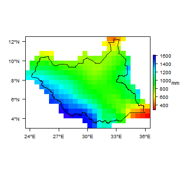 Average Annual Precipitation
 -
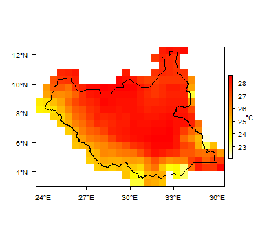 Average Temperature


For further detail on the climate datasets used see the climate resources section.
Surface water
|
|
 |
Soil
 |
Land cover
 |
Geology
The geology map shows a simplified version of the geology at a national scale. More information is available in the report UN (1988) (see References section, below). UPDATE TO CORRECT REPORT LINK
|
|
 |
Hydrogeology
The hydrogeology map below shows a simplified version of the type and productivity of the main aquifers at a national scale (see the Aquifer properties resource page for more details).
More information on the hydrogeology of South Sudan is available in the report UN (1988) (see References section, below). UPDATE WITH LINK TO CORRECT REPORT CHAPTER


Transboundary aquifers
For further information about transboundary aquifers, please see the Transboundary aquifers resources page.
References
References with more information on the geology and hydrogeology of South Sudan can be accessed through the Africa Groundwater Literature Archive.
Return to the index pages
Africa Groundwater Atlas >> Hydrogeology by country >> Hydrogeology of South Sudan