Hydrogeology of Central African Republic: Difference between revisions
No edit summary |
No edit summary |
||
| Line 1: | Line 1: | ||
[[Overview of Africa Groundwater Atlas | Africa Groundwater Atlas]] >> [[Hydrogeology by country | Hydrogeology by country]] >> Hydrogeology of the Central African Republic | [[Overview of Africa Groundwater Atlas | Africa Groundwater Atlas]] >> [[Hydrogeology by country | Hydrogeology by country]] >> Hydrogeology of the Central African Republic | ||
''' | '''The textual information on this page was taken from the publications listed in the reference section at the bottom of this page. If you have updated information on the hydrogeology of the Central African Republic, please get in touch.''' | ||
==Compilers== | ==Compilers== | ||
| Line 101: | Line 102: | ||
The geology map shows a simplified version of the geology at a national scale (see [[Geology | the Geology resources page]] for more details). | The geology map shows a simplified version of the geology at a national scale (see [[Geology | the Geology resources page]] for more details). | ||
Another geology map is available in the report by [http://pubs.usgs.gov/sir/2010/5043/pdf/sir2010-5043.pdf Chirico et al.]. 2010. | Another geology map is available in the report by [http://pubs.usgs.gov/sir/2010/5043/pdf/sir2010-5043.pdf Chirico et al.]. 2010. Much of the information on the geology below was derived from this report. | ||
[[File:Central African Republic_Geology.png | center]] | [[File:Central African Republic_Geology.png | center]] | ||
| Line 110: | Line 111: | ||
Most of the country is underlain by crystalline metamorphic Precambrian basement rocks of the African shield. | Most of the country is underlain by crystalline metamorphic Precambrian basement rocks of the African shield. | ||
Younger rocks cover only about a quarter of the country, mainly in the west and north, and smaller areas in the far south. They include Mesozoic | Younger rocks cover only about a quarter of the country, mainly in the west and north, and smaller areas in the far south. They include small outcrops of Palaeozoic sandstones; Mesozoic sandstones formations; Tertiary sandstone formations; and Quaternary lacustrine and alluvial deposits. | ||
| Line 117: | Line 118: | ||
|Key Formations||Period||Lithology | |Key Formations||Period||Lithology | ||
|- | |- | ||
!colspan="4"|Quaternary | !colspan="4"|Quaternary | ||
|- | |- | ||
|Lacustrine | |Lacustrine deposits, alluvium, laterite/ferricrete | ||
||Quaternary | ||Quaternary | ||
|| | ||Quaternary deposits are widespread in the Lake Chad basin in the north, comprising Neo-Chadian or Recent alluvium and lacustrine deposits with thick layers of recent clays (Chirico et al. 2010, United Nations 1988). Alluvium is also seen in river valleys across the country, and there are unconsolidated Quaternary deposits infilling depressions and swampy areas of the Sangha basin (United Nations 1988). | ||
Tropical chemical weathering has created extensive lateritic and ferricretic crusts across the country, which in places may be up to 40 m thick (Chirico et al. 2010). | |||
|- | |- | ||
!colspan="4"|Phanerozoic sedimentary | !colspan="4"|Phanerozoic sedimentary | ||
|- | |- | ||
|Tertiary | |Tertiary | ||
|| | ||Bambio Sandstone (in the south); Continental Terminal formations (north) | ||
||In the north are ferruginous sandstones, sands and cuirasses forming the edge of the Lake Chad basin. | ||In the north are Continental Terminal type formations in the Lake Chad basin, which form small distinct plateaus, and comprise ferruginous sandstones, sands and cuirasses forming the edge of the Lake Chad basin (Chirico et al. 2010, United Nations 1988). | ||
The Bambio Sandstone formation, comprising silicified sandstones, crops out in a small area in the southwest, overlying the Carnot Sandstone (Chirico et al. 2010, United Nations 1988). | |||
|- | |- | ||
|Cretaceous | |probably Cretaceous | ||
||Carnot and Mouka Ouadda | ||Carnot and Mouka Ouadda Sandstone formations; small outcrops in north | ||
|| | ||Mesozoic sedimentary rocks, probably mostly or all Cretaceous in age, form thick continental sequences resting in angular disconformity on the basement complex, in two outcrops that form distinct plateaus. | ||
In the west are the Carnot Sandstones, which are dominantly fluvial in origin, with some lacustrine deposits. They comprise a succession of conglomerates, sandstones and mudstones which can reach 300 to 400 m in thickness (Censier 1990, Chirico et al. 2010). | |||
In the east are the Mouka Ouddda Sandstones, also fluvial in origin, and generally less than 500 m thick. They comprise layers of sandstone and conglomerate (Chirico et al. 2010). | |||
|- | |- | ||
| | |Mambéré and Kombélé formations | ||
|| | ||Palaeozoic | ||
||The two major Paleozoic formations are the Mambéré Formation in the west of the country, and the Kombélé Formation in the east, both of glacial origin (Censier et Lang 1992, Chirico et al. 2010). The Mambéré Formation is a tillite composed of both basal and flow tills as well as reworked glacial deposits derived from sandstone, conglomeratic sandstone, and siltstone that occur in continuous beds, lenses, and isolated blocks. The Kombélé Formation is a conglomeratic-sandstone-tillite composed of glacial outwash sediments. Both the Mambéré and the Kombélé formations generally range in thickness from 30 to 50 m and are unconformably overlain by Cretaceous sandstone formations (Chirico et al. 2010). | ||The two major Paleozoic formations are the Mambéré Formation in the west of the country, and the Kombélé Formation in the east, both of glacial origin (Censier et Lang 1992, Chirico et al. 2010). The Mambéré Formation is a tillite composed of both basal and flow tills as well as reworked glacial deposits derived from sandstone, conglomeratic sandstone, and siltstone that occur in continuous beds, lenses, and isolated blocks. The Kombélé Formation is a conglomeratic-sandstone-tillite composed of glacial outwash sediments. Both the Mambéré and the Kombélé formations generally range in thickness from 30 to 50 m and are unconformably overlain by Cretaceous sandstone formations. The total extent of the Palaezoic formations in unknown, because it is overlain by more recent formations (Chirico et al. 2010). | ||
|- | |- | ||
!colspan="4"| Crystalline Basement | !colspan="4"| Crystalline Basement | ||
| Line 149: | Line 150: | ||
|Intrusive rocks | |Intrusive rocks | ||
||Proterozoic | ||Proterozoic | ||
||Discontinuous basic intrusions, including large masses of batholithic granite (e.g. the Bouar plateau and Mt Yade) and doloritic veins (e.g. upstream of Bangui and Nola region). | ||Discontinuous basic intrusions, including large masses of batholithic granite (e.g. the Bouar plateau and Mt Yade) and doloritic veins (e.g. upstream of Bangui and Nola region) (United Nations 1988). | ||
|- | |- | ||
| | | | ||
| Line 159: | Line 160: | ||
- a middle unit consisting mainly of carbonate formations with a glacial conglomerate at the base; and | - a middle unit consisting mainly of carbonate formations with a glacial conglomerate at the base; and | ||
- a lower unit represented by quartzites alternating with sericitic schists. | - a lower unit represented by quartzites alternating with sericitic schists (United Nations 1988). | ||
|- | |- | ||
|Granitic-gneissic basement | |Granitic-gneissic basement | ||
||Archean | ||Archean | ||
||A base complex subdivided into two groups: an upper group formed of quartzites and schists; and a lower group formed of gneisses, micaschists, amphibolites, granulites, migmatites and anatectic granites. | ||A base complex subdivided into two groups: an upper group formed of quartzites and schists; and a lower group formed of gneisses, micaschists, amphibolites, granulites, migmatites and anatectic granites (United Nations 1988). | ||
|} | |} | ||
Revision as of 16:24, 10 September 2015
Africa Groundwater Atlas >> Hydrogeology by country >> Hydrogeology of the Central African Republic
The textual information on this page was taken from the publications listed in the reference section at the bottom of this page. If you have updated information on the hydrogeology of the Central African Republic, please get in touch.
Compilers
Dr Kirsty Upton and Brighid Ó Dochartaigh, British Geological Survey, UK
Geographical Setting

General
The Central African Republic has a low relief formed by erosion, with occasional inselbergs forming isolated higher areas of ground. In the northeast and northwest of the country are small two mountain ranges which rise to over 1,300 m. A ridge of high ground between the two mountain ranges forms a boundary between the Lake Chad basin to the north, and the Congo basin to the south.
| Estimated Population in 2013* | 4,616,417 |
| Rural Population (% of total) (2013)* | 60.5% |
| Total Surface Area* | 622,980 sq km |
| Agricultural Land (% of total area) (2012)* | 8.2% |
| Capital City | Bangui |
| Region | Central Africa |
| Border Countries | Chad, Sudan, South Sudan, the Democratic Republic of the Congo, the Republic of the Congo, Cameroon |
| Annual Freshwater Withdrawal (2013)* | 72.5 Million cubic metres |
| Annual Freshwater Withdrawal for Agriculture (2013)* | 0.6% |
| Annual Freshwater Withdrawal for Domestic Use (2013)* | 82.9% |
| Annual Freshwater Withdrawal for Industry (2013)* | 16.6% |
| Rural Population with Access to Improved Water Source (2012)* | 54.4% |
| Urban Population with Access to Improved Water Source (2012)* | 89.6% |
* Source: World Bank
Climate
The Central African Republic has a tropical to semi-arid climate, with average annual rainfall ranging from 1,700 mm in the south to 700 mm in the north. There are two wet seasons, the main one in August-September and the smaller one in May-June.
Average temperatures range from about 23 degrees in the south to 26 degrees in the north, with a larger seasonal variation in temperatures in the north. Calculated evaporation potential ranges from 1,500 mm/year in the south to over 1,900 mm/year in the north.
-
 Koppen Geiger Climate Zones
 -
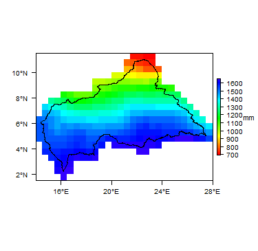 Average Annual Precipitation
 -
 Average Temperature


For further detail on the climate datasets used see the climate resources section.
Surface water
|
The north of the country is part of the Lake Chad basin, with sometimes ephemeral rivers draining to the Chari and the Logone, both of which flow into Chad and to Lake Chad. The south is part of the Congo basin, and the main rivers are the Obangui and the Sangha, and their tributaries, which are largely perennial. |
 |
Soil
|
Most soils are plinthosols, ferrasols or arenosols, with some acrisols.  |
Land cover
|
The south of the country is dominated by evergreen tropical forest. Much of the central part of the country is dominated by decidous forest and grassland. In the north, the dominant land cover is mostly shrubland. |
 |
Geology
This section provides a summary of the geology of the Central African Republic. More information is available in the report ‘Groundwater in North and West Africa’ (1988) (see References section, below).
The geology map shows a simplified version of the geology at a national scale (see the Geology resources page for more details).
Another geology map is available in the report by Chirico et al.. 2010. Much of the information on the geology below was derived from this report.

Summary
Most of the country is underlain by crystalline metamorphic Precambrian basement rocks of the African shield.
Younger rocks cover only about a quarter of the country, mainly in the west and north, and smaller areas in the far south. They include small outcrops of Palaeozoic sandstones; Mesozoic sandstones formations; Tertiary sandstone formations; and Quaternary lacustrine and alluvial deposits.
| Key Formations | Period | Lithology | |
| Quaternary | |||
|---|---|---|---|
| Lacustrine deposits, alluvium, laterite/ferricrete | Quaternary | Quaternary deposits are widespread in the Lake Chad basin in the north, comprising Neo-Chadian or Recent alluvium and lacustrine deposits with thick layers of recent clays (Chirico et al. 2010, United Nations 1988). Alluvium is also seen in river valleys across the country, and there are unconsolidated Quaternary deposits infilling depressions and swampy areas of the Sangha basin (United Nations 1988).
Tropical chemical weathering has created extensive lateritic and ferricretic crusts across the country, which in places may be up to 40 m thick (Chirico et al. 2010). | |
| Phanerozoic sedimentary | |||
| Tertiary | Bambio Sandstone (in the south); Continental Terminal formations (north) | In the north are Continental Terminal type formations in the Lake Chad basin, which form small distinct plateaus, and comprise ferruginous sandstones, sands and cuirasses forming the edge of the Lake Chad basin (Chirico et al. 2010, United Nations 1988).
The Bambio Sandstone formation, comprising silicified sandstones, crops out in a small area in the southwest, overlying the Carnot Sandstone (Chirico et al. 2010, United Nations 1988). | |
| probably Cretaceous | Carnot and Mouka Ouadda Sandstone formations; small outcrops in north | Mesozoic sedimentary rocks, probably mostly or all Cretaceous in age, form thick continental sequences resting in angular disconformity on the basement complex, in two outcrops that form distinct plateaus.
In the west are the Carnot Sandstones, which are dominantly fluvial in origin, with some lacustrine deposits. They comprise a succession of conglomerates, sandstones and mudstones which can reach 300 to 400 m in thickness (Censier 1990, Chirico et al. 2010). In the east are the Mouka Ouddda Sandstones, also fluvial in origin, and generally less than 500 m thick. They comprise layers of sandstone and conglomerate (Chirico et al. 2010). | |
| Mambéré and Kombélé formations | Palaeozoic | The two major Paleozoic formations are the Mambéré Formation in the west of the country, and the Kombélé Formation in the east, both of glacial origin (Censier et Lang 1992, Chirico et al. 2010). The Mambéré Formation is a tillite composed of both basal and flow tills as well as reworked glacial deposits derived from sandstone, conglomeratic sandstone, and siltstone that occur in continuous beds, lenses, and isolated blocks. The Kombélé Formation is a conglomeratic-sandstone-tillite composed of glacial outwash sediments. Both the Mambéré and the Kombélé formations generally range in thickness from 30 to 50 m and are unconformably overlain by Cretaceous sandstone formations. The total extent of the Palaezoic formations in unknown, because it is overlain by more recent formations (Chirico et al. 2010). | |
| Crystalline Basement | |||
| Intrusive rocks | Proterozoic | Discontinuous basic intrusions, including large masses of batholithic granite (e.g. the Bouar plateau and Mt Yade) and doloritic veins (e.g. upstream of Bangui and Nola region) (United Nations 1988). | |
| Proterozoic | Not extensively metamorphosed. These rocks overlie the base complex and are subdivided into three units:
- an upper unit with a series of schists, quartzites, limestones and sandstones; - a middle unit consisting mainly of carbonate formations with a glacial conglomerate at the base; and - a lower unit represented by quartzites alternating with sericitic schists (United Nations 1988). | ||
| Granitic-gneissic basement | Archean | A base complex subdivided into two groups: an upper group formed of quartzites and schists; and a lower group formed of gneisses, micaschists, amphibolites, granulites, migmatites and anatectic granites (United Nations 1988). | |
Hydrogeology
This section provides a summary of the hydrogeology of the main aquifers in the Central African Republic. More information is available in the report ‘Groundwater in North and West Africa’ (1988) (see References section, below).
The hydrogeology map shows a simplified version of the type and productivity of the main aquifers at a national scale (see the Aquifer properties resource page for more details).


Unconsolidated
| Named Aquifers | Period | General Description | Water quality |
Sedimentary - Intergranular Flow
| Named Aquifers | Period | General Description | Water quality |
Sedimentary - Intergranular & Fracture Flow
| Named Aquifers | Period | General Description | Water quality |
Sedimentary - Fracture Flow
| Named Aquifers | Period | General Description | Water quality |
Basement
| Named Aquifers | Period | General Description | Water quality |
Groundwater Status
Groundwater quantity
Groundwater quality
Groundwater use and management
Groundwater use
Groundwater management
Groundwater monitoring
Transboundary aquifers
For further information about transboundary aquifers, please see the Transboundary aquifers resources page
References
The following references provide more information on the geology and hydrogeology of the Central African Republic.
These, and others, can be accessed through the Africa Groundwater Literature Archive EDIT THE LINK TO CORRECT COUNTRY!!
Censier C. 1990. Characteristics of Mesozoic fluvio-lacustrine formations of the western Central African Republic (Carnot Sandstones) by means of mineralogical and exoscopic analyses of detrital material. Journal of African Earth Sciences Vol.10, Issues 1-2, pp 385-398.
Censier C et Lang J. 1992. La formation glaciaire de la Mambéré (République Centrafricaine), Reconstitution paléogéographique et implications à l’échelle du Paléozoïque africain. Geologische Rundschau, Vol.81, No. 3, pp 769-789
Chirico PG, Barthélémy F and Ngbokoto FA. 2010. Alluvial Diamond Resource Potential and Production Capacity Assessment of the Central African Republic. Prepared in cooperation with the Bureau de Recherches Géologiques et Minières and the Direction Générale des Mines under the auspices of the U.S. Department of State; Scientific Investigations Report 2010–5043.
United Nations. 1988. Groundwater in North and West Africa: Central African Republic. United Nations Department of Technical Cooperation for Development and Economic Commission for Africa. Natural Resources/Water Series No.18, ST/TCD/5.
Return to the index pages
Africa Groundwater Atlas >> Hydrogeology by country >> Hydrogeology of the Central African Republic