Hydrogeology of Angola: Difference between revisions
No edit summary |
No edit summary |
||
| Line 15: | Line 15: | ||
===General=== | ===General=== | ||
Angola is in central-southern Africa. | Angola is in central-southern Africa. The coastal lowlands are characterised by low plains and terraces. Hills and mountains rise inland from the coast into a major escarpment. Extending eastwards and southeastwards from the escarment is is a large area of high plateau (planalto). In the north is rainforest. The land elevation generally ranges from 900 to 1800 m, with the highest point at 2,620 m. | ||
{| class = "wikitable" | {| class = "wikitable" | ||
| Line 50: | Line 51: | ||
===Climate=== | ===Climate=== | ||
Most of Angola has a dry season from May to October and a rainy season from February to April, with transitional rains from November to January. The south of the country, and along parts of the coastal strip, are semi-arid. The far north sees rainfall throughout much of the year. The climate is greatly influenced by prevailing winds from the west and southwest. | |||
The average temperature on the coast is 16 °C in the winter and 21 °C in the summer, while the interior is generally hotter and dryer. | |||
<gallery widths="375px" heights=365px mode=nolines> | <gallery widths="375px" heights=365px mode=nolines> | ||
| Line 66: | Line 71: | ||
|- | |- | ||
| | | | ||
The Zambezi River and several tributaries of the Congo River have their sources in Angola. The mouth of the Congo River forms part of the northern border with the Democratic Republic of the Congo. Many rivers originate in the central uplands, but take quite different flowpaths. Some flow more or less due westerly to the Atlantic, providing water for irrigation and the potential for hydroelectric power in the dry coastal strip. Two of the largest rivers, the Cuanza (Kwanza) and the Cunene (Kunene), take a more indirect route to the Atlantic, the Cuanza flowing north and the Cunene flowing south before turning west. navigable. The Kwango and other rivers flow north from the high plateau to join the Kasai River (one of the largest tributaries of the Congo). Some rivers flow south into the Zambezi River system and from there to the Indian Ocean; others to the Okavango River (called the Cubango River in Angola) and thence to the Okavango Swamp in Botswana. | |||
Most rivers in Angola are perennial, but the tributaries of the Cubango River and several of the southern rivers flowing to the Atlantic are seasonal and are dry for much of the year. | |||
| Line 83: | Line 92: | ||
|- | |- | ||
| | | | ||
In the far south and southwest of Angola, land cover is dominated by desert or sparse savannah or grassland vegetation. This gives way northwards to shrubland and then to a mix of shrubland then to deciduous forest, which covers much of the rest of the country. | |||
| [[File:Angola_LandCover.png | frame | Land Cover Map of Angola (For map key and more information on the datasets used in the map see the [[Land cover | land cover resources section]])]] | | [[File:Angola_LandCover.png | frame | Land Cover Map of Angola (For map key and more information on the datasets used in the map see the [[Land cover | land cover resources section]])]] | ||
| Line 91: | Line 104: | ||
==Geology== | ==Geology== | ||
This section provides a summary of the geology of Angola. More information is available in the report [ | This section provides a summary of the geology of Angola. More information is available in the report[http://www.bgs.ac.uk/africagroundwateratlas/fulldetails.cfm?id=AGLA060001 ‘Groundwater in Eastern, Central and Southern Africa’] (UN 1989) (see References section, below). | ||
The geology map shows a simplified version of the geology at a national scale (see [[Geology | the Geology resources page]] for more details). | The geology map shows a simplified version of the geology at a national scale (see [[Geology | the Geology resources page]] for more details). | ||
| Line 135: | Line 148: | ||
==Hydrogeology== | ==Hydrogeology== | ||
This section provides a summary of the hydrogeology of the main aquifers in Angola. More information is available in the report [ | This section provides a summary of the hydrogeology of the main aquifers in Angola. More information is available in the report[http://www.bgs.ac.uk/africagroundwateratlas/fulldetails.cfm?id=AGLA060001 ‘Groundwater in Eastern, Central and Southern Africa’] (UN 1989) (see References section, below). | ||
The hydrogeology map shows a simplified version of the type and productivity of the main aquifers at a national scale (see [[Aquifer properties| the Aquifer properties resource page]] for more details). | The hydrogeology map shows a simplified version of the type and productivity of the main aquifers at a national scale (see [[Aquifer properties| the Aquifer properties resource page]] for more details). | ||
Revision as of 17:48, 16 September 2015
Africa Groundwater Atlas >> Hydrogeology by country >> Hydrogeology of Angola
Most of the textual information on this page was taken from the chapter on Angola in the report ‘Groundwater in Eastern, Central and Southern Africa’ (UN 1989).This information is outdated. If you have more recent information on the hydrogeology of Angola, please get in touch.
Compilers
Dr Kirsty Upton and Brighid Ó Dochartaigh, British Geological Survey, UK
Geographical Setting

General
Angola is in central-southern Africa. The coastal lowlands are characterised by low plains and terraces. Hills and mountains rise inland from the coast into a major escarpment. Extending eastwards and southeastwards from the escarment is is a large area of high plateau (planalto). In the north is rainforest. The land elevation generally ranges from 900 to 1800 m, with the highest point at 2,620 m.
| Estimated Population in 2013* | 21,471,618 |
| Rural Population (% of total) (2013)* | 57.5% |
| Total Surface Area* | 1,246,700 sq km |
| Agricultural Land (% of total area) (2012)* | 47.5% |
| Capital City | Luanda |
| Region | Central Africa |
| Border Countries | Namibia, the Democratic Republic of the Congo, Zambia |
| Annual Freshwater Withdrawal (2013)* | 708.8 Million cubic metres |
| Annual Freshwater Withdrawal for Agriculture (2013)* | 20.8% |
| Annual Freshwater Withdrawal for Domestic Use (2013)* | 45.3% |
| Annual Freshwater Withdrawal for Industry (2013)* | 33.9% |
| Rural Population with Access to Improved Water Source (2012)* | 34.3% |
| Urban Population with Access to Improved Water Source (2012)* | 67.6% |
* Source: World Bank
Climate
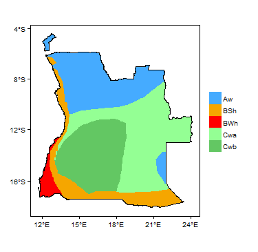
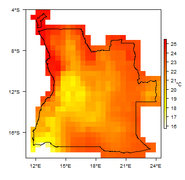
Most of Angola has a dry season from May to October and a rainy season from February to April, with transitional rains from November to January. The south of the country, and along parts of the coastal strip, are semi-arid. The far north sees rainfall throughout much of the year. The climate is greatly influenced by prevailing winds from the west and southwest.
The average temperature on the coast is 16 °C in the winter and 21 °C in the summer, while the interior is generally hotter and dryer.
-
 Koppen Geiger Climate Zones
 -
 Average Annual Precipitation
 -
 Average Temperature


For further detail on the climate datasets used see the climate resources section.
Surface water
|
The Zambezi River and several tributaries of the Congo River have their sources in Angola. The mouth of the Congo River forms part of the northern border with the Democratic Republic of the Congo. Many rivers originate in the central uplands, but take quite different flowpaths. Some flow more or less due westerly to the Atlantic, providing water for irrigation and the potential for hydroelectric power in the dry coastal strip. Two of the largest rivers, the Cuanza (Kwanza) and the Cunene (Kunene), take a more indirect route to the Atlantic, the Cuanza flowing north and the Cunene flowing south before turning west. navigable. The Kwango and other rivers flow north from the high plateau to join the Kasai River (one of the largest tributaries of the Congo). Some rivers flow south into the Zambezi River system and from there to the Indian Ocean; others to the Okavango River (called the Cubango River in Angola) and thence to the Okavango Swamp in Botswana. Most rivers in Angola are perennial, but the tributaries of the Cubango River and several of the southern rivers flowing to the Atlantic are seasonal and are dry for much of the year.
|
 |
Soil
 |
Land cover
|
In the far south and southwest of Angola, land cover is dominated by desert or sparse savannah or grassland vegetation. This gives way northwards to shrubland and then to a mix of shrubland then to deciduous forest, which covers much of the rest of the country.
|
 |
Geology
This section provides a summary of the geology of Angola. More information is available in the report‘Groundwater in Eastern, Central and Southern Africa’ (UN 1989) (see References section, below).
The geology map shows a simplified version of the geology at a national scale (see the Geology resources page for more details).

| Key Formations | Period | Lithology | |
| Geological Environment 1 | |||
|---|---|---|---|
| Name of formation1 | Time period | Description | |
| Geological Environment 2 | |||
| Geological Environment 3 | |||
Hydrogeology
This section provides a summary of the hydrogeology of the main aquifers in Angola. More information is available in the report‘Groundwater in Eastern, Central and Southern Africa’ (UN 1989) (see References section, below).
The hydrogeology map shows a simplified version of the type and productivity of the main aquifers at a national scale (see the Aquifer properties resource page for more details).


Unconsolidated
| Named Aquifers | Period | General Description | Water quality |
Sedimentary - Intergranular Flow
| Named Aquifers | Period | General Description | Water quality |
Sedimentary - Intergranular & Fracture Flow
| Named Aquifers | Period | General Description | Water quality |
Sedimentary - Fracture Flow
| Named Aquifers | Period | General Description | Water quality |
Basement
| Named Aquifers | Period | General Description | Water quality |
Groundwater Status
Groundwater quantity
Groundwater quality
Groundwater use and management
Groundwater use
Groundwater management
Groundwater monitoring
Transboundary aquifers
For further information about transboundary aquifers, please see the Transboundary aquifers resources page
References
The following references provide more information on the geology and hydrogeology of Angola.
These, and others, can be accessed through the Africa Groundwater Literature Archive
United Nations. 1989. Groundwater in Eastern, Central and Southern Africa: Angola. United Nations Department of Technical Cooperation for Development, Natural Resources/Water Series No.19, ST/TCD/6.
Return to the index pages
Africa Groundwater Atlas >> Hydrogeology by country >> Hydrogeology of Angola