Hydrogeology of Equatorial Guinea: Difference between revisions
m Protected "Hydrogeology of Equatorial Guinea" ([Edit=Allow only administrators] (indefinite) [Move=Allow only administrators] (indefinite)) [cascading] |
No edit summary |
||
| Line 1: | Line 1: | ||
[[Africa Groundwater Atlas Home | Africa Groundwater Atlas]] >> [[Hydrogeology by country | Hydrogeology by country]] >> Hydrogeology of Equatorial Guinea | |||
'''If you have more recent information on the hydrogeology of Equatorial Guinea , please get in touch.''' | |||
== | ==Compilers== | ||
'''Dr Kirsty Upton''' and '''Brighid Ó Dochartaigh''', British Geological Survey, UK | |||
==[[ | ==Geographical Setting== | ||
Equatorial Guinea consists of two parts, an island and a mainland region. The island region consists of the islands of Bioko in the Gulf of Guinea, and Annobón, a small volcanic island south of the equator. The capital Malabo is on Bioko Island. The mainland region is Río Muni, where Bata, the largest city, and Oyala, the country's planned future capital, are located. Rio Muni also includes several small offshore islands, such as Corisco, Elobey Grande, and Elobey Chico. | |||
[[File:Equatorial Guinea_Political.png | right | frame | Map of Equatorial Guinea (For more information on the datasets used in the map see the [[Geography | geography resources section]])]] | |||
===General=== | |||
{| class = "wikitable" | |||
|- | |||
|Estimated Population in 2013* || 757,014 | |||
|- | |||
|Rural Population (% of total) (2013)* || 60.4% | |||
|- | |||
|Total Surface Area* || 28,050 sq km | |||
|- | |||
|Agricultural Land (% of total area) (2012)* || 10.1% | |||
|- | |||
|Capital City || Malabo | |||
|- | |||
|Region || Western Africa | |||
|- | |||
|Border Countries || The mainland region is bordered by Cameroon and Gabon | |||
|- | |||
|Annual Freshwater Withdrawal (2013)* || 17.4 Million cubic metres | |||
|- | |||
|Annual Freshwater Withdrawal for Agriculture (2013)* || 5.7% | |||
|- | |||
|Annual Freshwater Withdrawal for Domestic Use (2013)* || 79.3% | |||
|- | |||
|Annual Freshwater Withdrawal for Industry (2013)* || 14.9% | |||
|- | |||
|Rural Population with Access to Improved Water Source (2012)* || n/a | |||
|- | |||
|Urban Population with Access to Improved Water Source (2012)* || n/a | |||
|} | |||
<nowiki>*</nowiki> Source: World Bank | |||
===Climate=== | |||
<gallery widths="375px" heights=365px mode=nolines> | |||
File:Equatorial Guinea_ClimateZones.png |Koppen Geiger Climate Zones | |||
File:Equatorial Guinea_ClimatePrecip.png |Average Annual Precipitation | |||
File:Equatorial Guinea_ClimateTemp.png |Average Temperature | |||
</gallery> | |||
[[File:Equatorial Guinea_pre_Monthly.png| 255x124px| Average monthly precipitation for Equatorial Guinea showing minimum and maximum (light blue), 25th and 75th percentile (blue), and median (dark blue) rainfall]] [[File:Equatorial Guinea_tmp_Monthly.png| 255x124px| Average monthly temperature for Equatorial Guinea showing minimum and maximum (orange), 25th and 75th percentile (red), and median (black) temperature]] [[File:Equatorial Guinea_pre_Qts.png | 255x124px | Quarterly precipitation over the period 1950-2012]] [[File:Equatorial Guinea_pre_Mts.png|255x124px | Monthly precipitation (blue) over the period 2000-2012 compared with the long term monthly average (red)]] | |||
For further detail on the climate datasets used see the [[Climate | climate resources section]]. | |||
===Surface water=== | |||
{| | |||
|- | |||
| | |||
| [[File:Equatorial Guinea_Hydrology.png | frame | Surface Water Map of Equatorial Guinea (For more information on the datasets used in the map see the [[Surface water | surface water resources section]])]] | |||
|} | |||
===Soil=== | |||
{| | |||
|- | |||
| [[File:Equatorial Guinea_soil.png | frame | Soil Map of Equatorial Guinea (For map key and more information on the datasets used in the map see the [[Soil | soil resources section]])]] | |||
| | |||
|} | |||
===Land cover=== | |||
{| | |||
|- | |||
| | |||
| [[File:Equatorial Guinea_LandCover.png | frame | Land Cover Map of Equatorial Guinea (For map key and more information on the datasets used in the map see the [[Land cover | land cover resources section]])]] | |||
|} | |||
==Geology== | |||
The geology map shows a simplified version of the geology at a national scale. More information is available in the report [http://www.bgs.ac.uk/africagroundwateratlas/fulldetails.cfm?id=AGLA060008 UN (1988)] (see References section, below). | |||
{| | |||
|- | |||
| | |||
| [[File:Equatorial Guinea_Geology.png | frame | Simplified Geology of Equatorial Guinea (For more information on the datasets used in the map see the [[Geology | the Geology resources page]])]] | |||
|} | |||
==Hydrogeology== | ==Hydrogeology== | ||
The hydrogeology map below shows a simplified version of the type and productivity of the main aquifers at a national scale (see [[Aquifer properties| the Aquifer properties resource page]] for more details). | |||
More information on the hydrogeology of Equatorial Guinea is available in the report [http://www.bgs.ac.uk/africagroundwateratlas/fulldetails.cfm?id=AGLA060008 UN (1988)] (see References section, below). | |||
[[File:Equatorial Guinea_Hydrogeology.png]] [[File: Hydrogeology_Key.png | 500x195px]] | |||
=== Transboundary aquifers=== | |||
For further information about transboundary aquifers, please see the [[Transboundary aquifers | Transboundary aquifers resources page]]. | |||
== | ==References== | ||
=== | References with more information on the geology and hydrogeology of Equatorial Guinea can be accessed through the [http://www.bgs.ac.uk/africagroundwateratlas/searchResults.cfm?title_search=&author_search=&category_search=&country_search=GQ&placeboolean=AND&singlecountry=1 Africa Groundwater Literature Archive]. | ||
United Nations. 1989. [http://www.bgs.ac.uk/africagroundwateratlas/fulldetails.cfm?id=AGLA060008 Groundwater in Eastern, Central and Southern Africa: Equatorial Guinea]. United Nations Department of Technical Cooperation for Development. | |||
==Return to the index pages== | |||
[[Africa Groundwater Atlas Home | Africa Groundwater Atlas]] >> [[Hydrogeology by country | Hydrogeology by country]] >> Hydrogeology of Equatorial Guinea | |||
<!-- PLEASE DO NOT DELETE BELOW THIS LINE --> | <!-- PLEASE DO NOT DELETE BELOW THIS LINE --> | ||
[[Category:Hydrogeology by country|e]] | [[Category:Hydrogeology by country|e]] | ||
Revision as of 15:01, 22 September 2015
Africa Groundwater Atlas >> Hydrogeology by country >> Hydrogeology of Equatorial Guinea
If you have more recent information on the hydrogeology of Equatorial Guinea , please get in touch.
Compilers
Dr Kirsty Upton and Brighid Ó Dochartaigh, British Geological Survey, UK
Geographical Setting
Equatorial Guinea consists of two parts, an island and a mainland region. The island region consists of the islands of Bioko in the Gulf of Guinea, and Annobón, a small volcanic island south of the equator. The capital Malabo is on Bioko Island. The mainland region is Río Muni, where Bata, the largest city, and Oyala, the country's planned future capital, are located. Rio Muni also includes several small offshore islands, such as Corisco, Elobey Grande, and Elobey Chico.

General
| Estimated Population in 2013* | 757,014 |
| Rural Population (% of total) (2013)* | 60.4% |
| Total Surface Area* | 28,050 sq km |
| Agricultural Land (% of total area) (2012)* | 10.1% |
| Capital City | Malabo |
| Region | Western Africa |
| Border Countries | The mainland region is bordered by Cameroon and Gabon |
| Annual Freshwater Withdrawal (2013)* | 17.4 Million cubic metres |
| Annual Freshwater Withdrawal for Agriculture (2013)* | 5.7% |
| Annual Freshwater Withdrawal for Domestic Use (2013)* | 79.3% |
| Annual Freshwater Withdrawal for Industry (2013)* | 14.9% |
| Rural Population with Access to Improved Water Source (2012)* | n/a |
| Urban Population with Access to Improved Water Source (2012)* | n/a |
* Source: World Bank
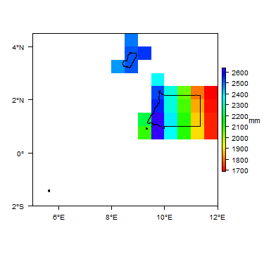
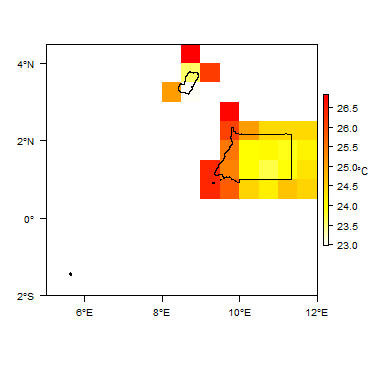
Climate
-
 Koppen Geiger Climate Zones
 -
 Average Annual Precipitation
 -
 Average Temperature


For further detail on the climate datasets used see the climate resources section.
Surface water
|
|
 |
Soil
 |
Land cover
Geology
The geology map shows a simplified version of the geology at a national scale. More information is available in the report UN (1988) (see References section, below).
|
|
 |
Hydrogeology
The hydrogeology map below shows a simplified version of the type and productivity of the main aquifers at a national scale (see the Aquifer properties resource page for more details).
More information on the hydrogeology of Equatorial Guinea is available in the report UN (1988) (see References section, below).


Transboundary aquifers
For further information about transboundary aquifers, please see the Transboundary aquifers resources page.
References
References with more information on the geology and hydrogeology of Equatorial Guinea can be accessed through the Africa Groundwater Literature Archive.
United Nations. 1989. Groundwater in Eastern, Central and Southern Africa: Equatorial Guinea. United Nations Department of Technical Cooperation for Development.
Return to the index pages
Africa Groundwater Atlas >> Hydrogeology by country >> Hydrogeology of Equatorial Guinea