Hydrogeology of Niger: Difference between revisions
No edit summary |
No edit summary |
||
| Line 119: | Line 119: | ||
|Chad Formation | |Chad Formation | ||
||Cretaceous - Quaternary | ||Cretaceous - Quaternary | ||
||The Chad Formation is of Quaternary age, and reaches many 100s of metres thick. It consists of unconsolidated fine to coarse grained sands and gravels with sandy clays. These are lake-margin, alluvial fan, deltaic and aeolian deposits, interbedded with lacustrine clay layers. Abrupt changes in clay and sand content are common, and the sediments usually occur as overlapping lenses. | ||The Chad Basin includes a great thickness of sedimentary rocks. The uppermost Chad Formation is largely of Quaternary (sometimes Tertiary) age, sometimes known as the Continental Terminal, and reaches many 100s of metres thick. It consists of unconsolidated fine to coarse grained sands and gravels with sandy clays. These are lake-margin, alluvial fan, deltaic and aeolian deposits, interbedded with lacustrine clay layers. Abrupt changes in clay and sand content are common, and the sediments usually occur as overlapping lenses. | ||
The Chad Formation is underlain by Tertiary and some Cretaceous age sedimentary rocks, from loosely cemented sandstones to shales, siltstones, mudstones, ironstones, lignites and conglomerates, and coals in some places. | The Chad Formation is underlain by Tertiary and some Cretaceous age sedimentary rocks, from loosely cemented sandstones to shales, siltstones, mudstones, ironstones, lignites and conglomerates, and coals in some places. | ||
|- | |- | ||
!colspan="4"| Iullemeden Basin - Sedimentary | !colspan="4"| Iullemeden Basin - Sedimentary | ||
| Line 131: | Line 127: | ||
| | | | ||
||Cretaceous - Tertiary | ||Cretaceous - Tertiary | ||
|| | ||The Iullemeden Basin stretches across parts of Mali, Niger, Benin and northwest Nigeria (called the Sokoto Basin in northwestern Nigeria). The sedimentary sequence includes, from oldest to youngest, sandstones and mudstones of the Continental Intercalaire; marine limestones, dolomitic limestones and sandstones of Cenomanian to Turonian age; argillaceous rocks of the Upper Cretaceous; and chalky limestones, mudstones and shales of Tertiary age. The total sedimentary sequence in the basin reaches several thousand metres thick. | ||
|- | |- | ||
!colspan="4"|Mesozoic to Palaeozoic Sedimentary | !colspan="4"|Mesozoic to Palaeozoic Sedimentary | ||
| Line 141: | Line 133: | ||
| | | | ||
||Cambrian to Cretaceous | ||Cambrian to Cretaceous | ||
||These sedimentary rocks include | ||These sedimentary rocks include Ordovician sandstones and limestones and Carbonifereous to Devonian calcareous sandstones and claystones, of fluviatile, lacustrine and marine origin. | ||
|- | |- | ||
!colspan="4"| Basement | !colspan="4"| Basement | ||
| Line 180: | Line 168: | ||
|Named Aquifers||Period||General Description||Water quality | |Named Aquifers||Period||General Description||Water quality | ||
|- | |- | ||
| | |Chad Formation / Continental Terminal | ||
|| | ||Tertiary - Quaternary | ||
|| | || | ||
|| | || | ||
| Line 222: | Line 209: | ||
==Groundwater Status== | ==Groundwater Status== | ||
==Groundwater use and management== | ==Groundwater use and management== | ||
=== Groundwater use=== | === Groundwater use=== | ||
Groundwater is a vital resource in Niger. | |||
=== Groundwater management=== | === Groundwater management=== | ||
Revision as of 15:22, 23 September 2015
Africa Groundwater Atlas >> Hydrogeology by country >> Hydrogeology of Niger
Most of the textual information on this page was taken from the chapter on Niger in the report
‘Groundwater in North and West Africa’ (UN 1988).
If you have more recent information on the hydrogeology of Niger, please get in touch.
Compilers
Dr Kirsty Upton and Brighid Ó Dochartaigh, British Geological Survey, UK
Geographical Setting

General
| Estimated Population in 2013* | 17,831,270 |
| Rural Population (% of total) (2013)* | 81.8% |
| Total Surface Area* | 1,266,700 sq km |
| Agricultural Land (% of total area) (2012)* | 35.4% |
| Capital City | Niamey |
| Region | Western Africa |
| Border Countries | Nigeria, Benin, Burkina Faso, Mali, Algeria, Libya, Chad. |
| Annual Freshwater Withdrawal (2013)* | 983.6 Million cubic metres |
| Annual Freshwater Withdrawal for Agriculture (2013)* | 66.7% |
| Annual Freshwater Withdrawal for Domestic Use (2013)* | 30.0% |
| Annual Freshwater Withdrawal for Industry (2013)* | 3.3% |
| Rural Population with Access to Improved Water Source (2012)* | 42.1% |
| Urban Population with Access to Improved Water Source (2012)* | 98.7% |
* Source: World Bank
Climate
-
 Koppen Geiger Climate Zones
 -
 Average Annual Precipitation
 -
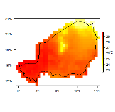 Average Temperature


For further detail on the climate datasets used see the climate resources section.
Surface water
|
|
 |
Soil
 |
Land cover
 |
Geology
This section provides a summary of the geology of Niger. More information is available in the report UN (1988) (see References section, below).
The geology map shows a simplified version of the geology at a national scale.
|
|
 |
| Key Formations | Period | Lithology | |
| Unconsolidated Sedimentary | |||
|---|---|---|---|
| Largely alluvium and aeolian deposits | Quaternary | Outcrops of Quaternary deposits occur across the country, including alluvium in river valleys, and areas of aeolian sand dunes in the more arid areas. | |
| Chad Basin - Sedimentary | |||
| Chad Formation | Cretaceous - Quaternary | The Chad Basin includes a great thickness of sedimentary rocks. The uppermost Chad Formation is largely of Quaternary (sometimes Tertiary) age, sometimes known as the Continental Terminal, and reaches many 100s of metres thick. It consists of unconsolidated fine to coarse grained sands and gravels with sandy clays. These are lake-margin, alluvial fan, deltaic and aeolian deposits, interbedded with lacustrine clay layers. Abrupt changes in clay and sand content are common, and the sediments usually occur as overlapping lenses.
The Chad Formation is underlain by Tertiary and some Cretaceous age sedimentary rocks, from loosely cemented sandstones to shales, siltstones, mudstones, ironstones, lignites and conglomerates, and coals in some places. | |
| Iullemeden Basin - Sedimentary | |||
| Cretaceous - Tertiary | The Iullemeden Basin stretches across parts of Mali, Niger, Benin and northwest Nigeria (called the Sokoto Basin in northwestern Nigeria). The sedimentary sequence includes, from oldest to youngest, sandstones and mudstones of the Continental Intercalaire; marine limestones, dolomitic limestones and sandstones of Cenomanian to Turonian age; argillaceous rocks of the Upper Cretaceous; and chalky limestones, mudstones and shales of Tertiary age. The total sedimentary sequence in the basin reaches several thousand metres thick. | ||
| Mesozoic to Palaeozoic Sedimentary | |||
| Cambrian to Cretaceous | These sedimentary rocks include Ordovician sandstones and limestones and Carbonifereous to Devonian calcareous sandstones and claystones, of fluviatile, lacustrine and marine origin. | ||
| Basement | |||
| Precambrian | Plutonic grantitic and gneissose and undifferentiated crystalline metamorphic rocks. | ||
Hydrogeology
This section provides a summary of the hydrogeology of the main aquifers in Niger. More information is available in the report UN (1988) (see References section, below).
The hydrogeology map shows a simplified version of the type and productivity of the main aquifers at a national scale (see the Aquifer properties resource page for more details).


Unconsolidated
| Named Aquifers | Period | General Description | Water quality |
Sedimentary - Intergranular Flow
| Named Aquifers | Period | General Description | Water quality |
| Chad Formation / Continental Terminal | Tertiary - Quaternary |
Sedimentary - Intergranular & Fracture Flow
| Named Aquifers | Period | General Description | Water quality |
Sedimentary - Fracture Flow
| Named Aquifers | Period | General Description | Water quality |
Basement
| Named Aquifers | Period | General Description | Water quality |
Groundwater Status
Groundwater use and management
Groundwater use
Groundwater is a vital resource in Niger.
Groundwater management
Groundwater monitoring
Transboundary aquifers
For further information about transboundary aquifers, please see the Transboundary aquifers resources page.
References
References with more information on the geology and hydrogeology of Niger can be accessed through the Africa Groundwater Literature Archive.
United Nations. 1988. Groundwater in North and West Africa: Niger. United Nations Department of Technical Cooperation for Development and Economic Commission for Africa.
Return to the index pages
Africa Groundwater Atlas >> Hydrogeology by country >> Hydrogeology of Niger