Hydrogeology of Sierra Leone: Difference between revisions
No edit summary |
|||
| Line 1: | Line 1: | ||
[[Overview of Africa Groundwater Atlas | Africa Groundwater Atlas]] >> [[Hydrogeology by country | Hydrogeology by country]] >> Hydrogeology of Sierra Leone | [[Overview of Africa Groundwater Atlas | Africa Groundwater Atlas]] >> [[Hydrogeology by country | Hydrogeology by country]] >> Hydrogeology of Sierra Leone | ||
'''This page has limited information, and needs to be updated. If you have more information on the hydrogeology of | '''This page has limited information, and needs to be updated. If you have more information on the hydrogeology of Sierra Leone, please get in touch!''' | ||
| Line 89: | Line 89: | ||
The geology map shows a simplified version of the geology at a national scale. More information is available in the report [http://www.bgs.ac.uk/africagroundwateratlas/fulldetails.cfm?id=AGLA060003 UN (1988)] (see References section, below). | The geology map shows a simplified version of the geology at a national scale. More information is available in the report [http://www.bgs.ac.uk/africagroundwateratlas/fulldetails.cfm?id=AGLA060003 UN (1988)] (see References section, below). | ||
Summary | |||
Most of Sierra Leone is underlain by Precambrian cratonic rocks of the African Shield. These are often capped by a weathered zone of unconsolidated material, where the Precambrian basement rocks have been weathered in-situ to sand, gravel and clay. They are also often capped by a layer of laterite or ferricrete. | |||
A major belt of Precambrian to Cambrian age metasedimentary rocks, with some (meta)volcanic rocks, occurs in the western part of the country, obducted over and infolded into the older cratonic rocks. It contains metaconglomerates and quartzites, various schists, metacherts and banded iron formations (BIF) (Camus and Cukor 2012). | |||
There are outcrops of intrusive igneous rocks across the country, which are generally of granitic composition, associated with Precambrian orogenic events (Camus and Cukor 2012). | |||
Across the country, in river valleys there are often unconsolidated alluvial deposits laid down by rivers. Along the coastal belt are extensive outcrops of coastal, alluvial and other Quaternary unconsolidated deposits, including beach sands. | |||
[[File:Sierra Leone_Geology.png | center ]] | [[File:Sierra Leone_Geology.png | center ]] | ||
| Line 116: | Line 125: | ||
The following report provides more information on the geology and hydrogeology of Sierra Leone. It, and others, can be accessed through the [http://www.bgs.ac.uk/africagroundwateratlas/searchResults.cfm?title_search=&author_search=&category_search=&country_search=SL&placeboolean=AND&singlecountry=1 Africa Groundwater Literature Archive] | The following report provides more information on the geology and hydrogeology of Sierra Leone. It, and others, can be accessed through the [http://www.bgs.ac.uk/africagroundwateratlas/searchResults.cfm?title_search=&author_search=&category_search=&country_search=SL&placeboolean=AND&singlecountry=1 Africa Groundwater Literature Archive] | ||
Camus Y and Cukor D. 2012. [http://www.poloresources.com/PDF/Nimini_Resource_Update_NI43-101.pdf NI 43-101 Technical Report on the Resource Update Nimini Gold Project, Kono Region, Sierra Leone]. SGS Canada Inc., submitted to Polo Resources Ltd. | |||
Flinch JF, Huedo JL, Verzi H, Gonzalez H, Gerster R, Mansaray AK, Painuly LP, Rodriguez-Blanco L, Herra A, Brisson I and Gerard J. 2009. [http://www.searchanddiscovery.com/pdfz/documents/2009/10224flinch/ndx_flinch.pdf.html The Sierra Leone-Liberia Emerging Deepwater Province]. Adapted from oral presentation at AAPG Annual Convention, Denver, Colorado, June 7-10, 2009. | |||
United Nations. 1988. [http://www.bgs.ac.uk/africagroundwateratlas/fulldetails.cfm?id=AGLA060048 Groundwater in North and West Africa: Sierra Leone]. United Nations Department of Technical Cooperation for Development and Economic Commission for Africa. Department of Technical Cooperation for Development and Economic Commission for Africa, Natural Resources/Water Series No. 18. | United Nations. 1988. [http://www.bgs.ac.uk/africagroundwateratlas/fulldetails.cfm?id=AGLA060048 Groundwater in North and West Africa: Sierra Leone]. United Nations Department of Technical Cooperation for Development and Economic Commission for Africa. Department of Technical Cooperation for Development and Economic Commission for Africa, Natural Resources/Water Series No. 18. | ||
Revision as of 15:54, 13 October 2015
Africa Groundwater Atlas >> Hydrogeology by country >> Hydrogeology of Sierra Leone
This page has limited information, and needs to be updated. If you have more information on the hydrogeology of Sierra Leone, please get in touch!
Compilers
Dr Kirsty Upton and Brighid Ó Dochartaigh, British Geological Survey, UK
Geographical Setting

General
| Estimated Population in 2013* | 6,092,075 |
| Rural Population (% of total) (2013)* | 60.8% |
| Total Surface Area* | 72,180 sq km |
| Agricultural Land (% of total area) (2012)* | 56.8% |
| Capital City | Freetown |
| Region | Western Africa |
| Border Countries | Guinea, Liberia |
| Annual Freshwater Withdrawal (2013)* | 212.2 Million cubic metres |
| Annual Freshwater Withdrawal for Agriculture (2013)* | 21.5% |
| Annual Freshwater Withdrawal for Domestic Use (2013)* | 52.3% |
| Annual Freshwater Withdrawal for Industry (2013)* | 26.2% |
| Rural Population with Access to Improved Water Source (2012)* | 42.4% |
| Urban Population with Access to Improved Water Source (2012)* | 87.1% |
* Source: World Bank
Climate
-
 Koppen Geiger Climate Zones
 -
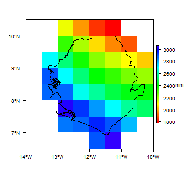 Average Annual Precipitation
 -
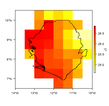 Average Temperature


For further detail on the climate datasets used see the climate resources section.
Surface water
|
|
 |
Soil
 |
Land cover
 |
Geology
The geology map shows a simplified version of the geology at a national scale. More information is available in the report UN (1988) (see References section, below).
Summary
Most of Sierra Leone is underlain by Precambrian cratonic rocks of the African Shield. These are often capped by a weathered zone of unconsolidated material, where the Precambrian basement rocks have been weathered in-situ to sand, gravel and clay. They are also often capped by a layer of laterite or ferricrete.
A major belt of Precambrian to Cambrian age metasedimentary rocks, with some (meta)volcanic rocks, occurs in the western part of the country, obducted over and infolded into the older cratonic rocks. It contains metaconglomerates and quartzites, various schists, metacherts and banded iron formations (BIF) (Camus and Cukor 2012).
There are outcrops of intrusive igneous rocks across the country, which are generally of granitic composition, associated with Precambrian orogenic events (Camus and Cukor 2012).
Across the country, in river valleys there are often unconsolidated alluvial deposits laid down by rivers. Along the coastal belt are extensive outcrops of coastal, alluvial and other Quaternary unconsolidated deposits, including beach sands.

Hydrogeology
The hydrogeology map below shows a simplified version of the type and productivity of the main aquifers at a national scale (see the Hydrogeology Map resource page for more details).
More information on the hydrogeology of Sierra Leone is available in the report United Nations (1988) (see References section, below).


Groundwater management
Information on groundwater sources (water points) is collected in certain districts, but there is no central national database. Borehole logs with geological information are not readily available.
Transboundary aquifers
For further information about transboundary aquifers, please see the Transboundary aquifers resources page
References
The following report provides more information on the geology and hydrogeology of Sierra Leone. It, and others, can be accessed through the Africa Groundwater Literature Archive
Camus Y and Cukor D. 2012. NI 43-101 Technical Report on the Resource Update Nimini Gold Project, Kono Region, Sierra Leone. SGS Canada Inc., submitted to Polo Resources Ltd.
Flinch JF, Huedo JL, Verzi H, Gonzalez H, Gerster R, Mansaray AK, Painuly LP, Rodriguez-Blanco L, Herra A, Brisson I and Gerard J. 2009. The Sierra Leone-Liberia Emerging Deepwater Province. Adapted from oral presentation at AAPG Annual Convention, Denver, Colorado, June 7-10, 2009.
United Nations. 1988. Groundwater in North and West Africa: Sierra Leone. United Nations Department of Technical Cooperation for Development and Economic Commission for Africa. Department of Technical Cooperation for Development and Economic Commission for Africa, Natural Resources/Water Series No. 18.
Return to the index pages
Africa Groundwater Atlas >> Hydrogeology by country >> Hydrogeology of Sierra Leone