Hydrogeology of Niger: Difference between revisions
No edit summary |
No edit summary |
||
| Line 19: | Line 19: | ||
==Geographical Setting== | ==Geographical Setting== | ||
[[File:Niger_Political.png | right | frame | Niger | [[File:Niger_Political.png | right | frame | Niger. Map developed from USGS GTOPOPO30; GADM global administrative areas; and UN Revision of World Urbanization Prospects. For more information on the map development and datasets see the [[Geography | geography resource page]].]] | ||
===General=== | ===General=== | ||
| Line 59: | Line 59: | ||
The northern part of Niger has an arid Saharan climate; the southern part has a semi-arid Sudano=Sahelian climate. Rainfall is irregular, but generally there is a dry season from October to May, and a wetter season from June to September. | The northern part of Niger has an arid Saharan climate; the southern part has a semi-arid Sudano=Sahelian climate. Rainfall is irregular, but generally there is a dry season from October to May, and a wetter season from June to September. | ||
These maps and graphs were developed from the CRU TS 3.21 dataset produced by the Climatic Research Unit at the University of East Anglia, UK. For more information see the [[Climate | climate resource page]]. | |||
<gallery widths="375px" heights=365px mode=nolines> | <gallery widths="375px" heights=365px mode=nolines> | ||
| Line 72: | Line 69: | ||
[[File:Niger_pre_Monthly.png| 255x124px| Average monthly precipitation for Niger showing minimum and maximum (light blue), 25th and 75th percentile (blue), and median (dark blue) rainfall]] [[File:Niger_tmp_Monthly.png| 255x124px| Average monthly temperature for Niger showing minimum and maximum (orange), 25th and 75th percentile (red), and median (black) temperature]] [[File:Niger_pre_Qts.png | 255x124px | Quarterly precipitation over the period 1950-2012]] [[File:Niger_pre_Mts.png|255x124px | Monthly precipitation (blue) over the period 2000-2012 compared with the long term monthly average (red)]] | [[File:Niger_pre_Monthly.png| 255x124px| Average monthly precipitation for Niger showing minimum and maximum (light blue), 25th and 75th percentile (blue), and median (dark blue) rainfall]] [[File:Niger_tmp_Monthly.png| 255x124px| Average monthly temperature for Niger showing minimum and maximum (orange), 25th and 75th percentile (red), and median (black) temperature]] [[File:Niger_pre_Qts.png | 255x124px | Quarterly precipitation over the period 1950-2012]] [[File:Niger_pre_Mts.png|255x124px | Monthly precipitation (blue) over the period 2000-2012 compared with the long term monthly average (red)]] | ||
===Surface water=== | ===Surface water=== | ||
| Line 81: | Line 78: | ||
| [[File:Niger_Hydrology.png | frame | Major surface water features of Niger | | [[File:Niger_Hydrology.png | frame | Major surface water features of Niger. Map developed from World Wildlife Fund HydroSHEDS; Digital Chart of the World drainage; and FAO Inland Water Bodies. For more information on the map development and datasets see the [[Surface water | surface water resource page]].]] | ||
|} | |} | ||
| Line 87: | Line 84: | ||
{| | {| | ||
|- | |- | ||
| [[File:Niger_soil.png | frame | Soil Map of Niger | | [[File:Niger_soil.png | frame | Soil Map of Niger, from the European Commission Joint Research Centre: European Soil Portal. For more information on the map see the [[Soil | soil resource page]].]] | ||
| | | | ||
| Line 97: | Line 94: | ||
| | | | ||
| [[File:Niger_LandCover.png | frame | Land Cover Map of Niger | | [[File:Niger_LandCover.png | frame | Land Cover Map of Niger, from the European Space Agency GlobCover 2.3, 2009. For more information on the map see the [[Land cover | land cover resource page]].]] | ||
|} | |} | ||
| Line 106: | Line 103: | ||
This section provides a summary of the geology of Niger. | This section provides a summary of the geology of Niger. | ||
The geology map shows a simplified | The geology map shows a simplified overview of the geology at a national scale. For more information on the datasets used in the map see the [[Geology | the Geology resource page]]. | ||
[[File:Niger_Geology2.png | center | thumb| 500px | Geology of Niger at 1:5 million scale. Developed from USGS map (Persits et al. 2002). For more information on the map development and datasets see the [[Geology | geology resource page]].]] | |||
[[File:Niger_Geology2.png | center | | |||
{| class = "wikitable" | {| class = "wikitable" | ||
| Line 155: | Line 149: | ||
This section provides a summary of the hydrogeology of the main aquifers in Niger. More information is available in the report [http://www.bgs.ac.uk/africagroundwateratlas/fulldetails.cfm?id=AGLA060045 UN (1988)] (see References section, below). | This section provides a summary of the hydrogeology of the main aquifers in Niger. More information is available in the report [http://www.bgs.ac.uk/africagroundwateratlas/fulldetails.cfm?id=AGLA060045 UN (1988)] (see References section, below). | ||
The hydrogeology map shows a simplified | The hydrogeology map shows a simplified overview of the type and productivity of the main aquifers at a national scale (see the [[Hydrogeology Map | Hydrogeology map resource page]] for more details). | ||
[[File:Niger_Hydrogeology2.png | center | thumb| 500px | Hydrogeology of Niger at 1:5 million scale. For more information on how the map was developed see the [[Hydrogeology Map | Hydrogeology map]] resource page]]. | |||
====Unconsolidated==== | ====Unconsolidated==== | ||
Revision as of 15:49, 25 April 2016
Africa Groundwater Atlas >> Hydrogeology by country >> Hydrogeology of Niger
The textual information on this page was taken from various sources, listed in the References section, below. If you have more information on the hydrogeology of Niger, please get in touch!
Compilers
Dr Kirsty Upton and Brighid Ó Dochartaigh, British Geological Survey, UK
Please cite this page as: Upton & Ó Dochartaigh, 2016.
Bibliographic reference: Upton, K. & Ó Dochartaigh, B.É. 2016. Africa Groundwater Atlas: Hydrogeology of Niger. British Geological Survey. Accessed [date you accessed the information]. http://earthwise.bgs.ac.uk/index.php/Hydrogeology_of_Niger
Terms and conditions
The Africa Groundwater Atlas is hosted by the British Geological Survey (BGS) and includes information from third party sources. Your use of information provided by this website is at your own risk. If reproducing diagrams that include third party information, please cite both the Africa Groundwater Atlas and the third party sources. Please see the Terms and Conditions for more information.
Geographical Setting

General
| Estimated Population in 2013* | 17,831,270 |
| Rural Population (% of total) (2013)* | 81.8% |
| Total Surface Area* | 1,266,700 sq km |
| Agricultural Land (% of total area) (2012)* | 35.4% |
| Capital City | Niamey |
| Region | Western Africa |
| Border Countries | Nigeria, Benin, Burkina Faso, Mali, Algeria, Libya, Chad. |
| Annual Freshwater Withdrawal (2013)* | 983.6 Million cubic metres |
| Annual Freshwater Withdrawal for Agriculture (2013)* | 66.7% |
| Annual Freshwater Withdrawal for Domestic Use (2013)* | 30.0% |
| Annual Freshwater Withdrawal for Industry (2013)* | 3.3% |
| Rural Population with Access to Improved Water Source (2012)* | 42.1% |
| Urban Population with Access to Improved Water Source (2012)* | 98.7% |
* Source: World Bank
Climate
The northern part of Niger has an arid Saharan climate; the southern part has a semi-arid Sudano=Sahelian climate. Rainfall is irregular, but generally there is a dry season from October to May, and a wetter season from June to September.
These maps and graphs were developed from the CRU TS 3.21 dataset produced by the Climatic Research Unit at the University of East Anglia, UK. For more information see the climate resource page.
-
 Koppen Geiger Climate Zones
 -
 Average Annual Precipitation
 -
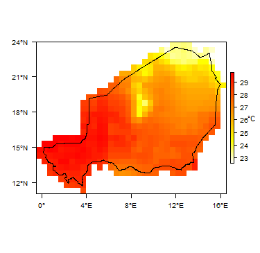 Average Temperature


Surface water
|
|
 |
Soil
 |
Land cover
 |
Geology
This section provides a summary of the geology of Niger.
The geology map shows a simplified overview of the geology at a national scale. For more information on the datasets used in the map see the the Geology resource page.

| Key Formations | Period | Lithology | |
| Unconsolidated Sedimentary | |||
|---|---|---|---|
| Largely alluvium and aeolian deposits | Quaternary | Outcrops of Quaternary deposits occur across the country, including alluvium in river valleys, and areas of aeolian sand dunes in the more arid areas. | |
| Chad Basin - Sedimentary | |||
| Chad Formation, Continental Terminal | Cretaceous - Quaternary | The Chad Basin includes a great thickness of sedimentary rocks. The uppermost Chad Formation is largely of Quaternary age, and can reach many 100s of metres thick. It consists of unconsolidated fine to coarse grained sands and gravels with sandy clays. These are lake-margin, alluvial fan, deltaic and aeolian deposits, interbedded with lacustrine clay layers. Abrupt changes in clay and sand content are common, and the sediments usually occur as overlapping lenses.
The Chad Formation is underlain by the largely Tertiary Continental Terminal formation, which consists of alternating, usually loosely consolidated, sandstones, siltstones, shales and mudstones. | |
| Iullemeden (or Niger) Basin - Sedimentary | |||
| Continental Intercalaire, Hamadian Continental, unconsolidated sediments | Cretaceous - Quaternary | The Iullemeden Basin stretches across parts of Mali, Niger, Benin and northwest Nigeria (called the Sokoto Basin in northwestern Nigeria). The sedimentary sequence includes, from oldest to youngest, sandstones and mudstones of the Continental Intercalaire; coarse grained sandstones of Middle and Upper Cretaceous age; marine and lagoonal limestones, dolomitic limestones and sandstones of Cenomanian to Turonian age; argillaceous siltstones and clays of the Upper Cretaceous; and chalky limestones, mudstones and shales of Tertiary age. Much of the basin is topped with unconsolidated Quaternary sediments, including aeolian sands and alluvial deposits.
The total sedimentary sequence in the basin reaches several thousand metres thick. | |
| Mesozoic to Palaeozoic Sedimentary | |||
| Cambrian to Cretaceous | These sedimentary rocks include Ordovician sandstones and limestones; Devonian argillaceous sandstones; Carboniferous calcareous sandstones; and sandstones and siltstones of Triassic and Jurassic age | ||
| Basement | |||
| Precambrian | Plutonic grantitic and gneissose and undifferentiated crystalline metamorphic rocks. | ||
Hydrogeology
This section provides a summary of the hydrogeology of the main aquifers in Niger. More information is available in the report UN (1988) (see References section, below).
The hydrogeology map shows a simplified overview of the type and productivity of the main aquifers at a national scale (see the Hydrogeology map resource page for more details).

.
Unconsolidated
| Named Aquifers | Period | General Description | Water quality |
| Alluvium, aeolian deposits | Quaternary | Where thick enough and dominated by sand and/or gravel, can be highly permeable with high storage potential. Alluvial deposits in valleys typically have shallow water tables and can form productive local aquifers. Aeolian deposits on plateaus can be dry. |
Sedimentary - Intergranular Flow
| Named Aquifers | Period | General Description | Water quality |
| Chad Basin (Chad Formation) | Quaternary | Overall, dominated by loosely consolidated sands with significant permeability, forming a highly productive aquifer. Some areas dominated by low permeability clays. Where clays are interbedded with sandstones, it forms a multilayered aquifer, sometimes artesian.
Surface layers recharged by direct rainfall infiltration; deeper layers have more restricted recharge. |
Sedimentary - Intergranular & Fracture Flow
| Named Aquifers | Period | General Description | Water quality |
| Chad Basin (Continental Terminal, Cretaceous-Tertiary undifferentiated) | Tertiary | Overall, dominated by sandstones with significant permeability, but some areas dominated by low permeability siltstones and clays. Where clays are interbedded with sandstones, it forms a multilayered aquifer, sometimes artesian.
Surface layers recharged by direct rainfall infiltration; deeper layers have more restricted recharge. |
|
| Iullemeden (Niger) Basin (Continental Intercalaire, Hamadian Continental, Cretaceous-Tertiary undifferentiated) | Cretaceous | Sandstones, often coarse grained, and clays, limestones and silts. Unconfined in its eastern part, becoming confined towards the west below younger clays, with artesian conditions found especially in deep valleys. The Tegama sandstones form a particularly productive aquifer unit, about 500 m thick, but buried beneath about 500 m of younger cover. Low direct recharge to unconfined areas because of low rainfall. | |
| Palaeozoic-Mesozoic sedimentary | Ordovician - Jurassic | Shallower, younger sandstones tend to show more intergranular flow; older, deeper sandstones and limestones tend to be dominated by fracture flow. Aquifers can be very deep - e.g. an Ordovician aquifer at more than 800 m deep.
Shallower aquifers typically form unconfined aquifer, with recharge from direct rainfall infiltration and from infilration of ephemeral river flow. Deeper aquifers are often confined, and artesian - e.g., the Carboniferous Farazekat sandstone aquifer has artesian flows of between 3 and 30 m³/hour. Deeper aquifers have relatively low recharge. |
Groundwater in deeper aquifers can be highly mineralised. |
Basement
| Named Aquifers | Period | General Description | Water quality |
| Basement | Precambrian | Discontinuous, low productivity aquifers controlled by the thickness and nature of weathering (regolith) and the presence of deeper fractures. Where weathered products are dominated by argillaceous material, yields are particularly low. |
Groundwater Status
Niger has vast quantities of stored groundwater in deep sedimentary aquifers, much of which is likely to be 'fossil' water that is not actively recharged, because of low rainfall. Shallower aquifers, particularly alluvial aquifers in valleys and local weathered (regolith) aquifers in basement, have much smaller amounts of groundwater storage and depend heavily on seasonal rainfall.
Some groundwater is highly mineralised, related to high evaporation (in shallow aquifers) and/or to age and dissolution of aquifer minerals; however, this is not recognised as a widespread problem (UNICEF 2010). Borehole databases indicate that fresh groundwater occurs across the southern region; there is not enough information for other areas to assess the situation (UNICEF 2010). There are also known local problems of bacterial and nitrate contamination, related to human and animal waste disposal (UNICEF 2010).
Groundwater use and management
Groundwater use
Groundwater is a vital resource in Niger, used for rural water supplies across the country, and for urban water supplies in some areas, such as Niamey.
Groundwater management and monitoring
A recent German Development Cooperation project, the Integrated Water Resources Management Programme is providing advice to the Niger Basin Authority on groundwater protection. Project work has included the collection and assessment of groundwater data and maps in the Niger basin in order to develop a groundwater database, and to form the basis for future development of a basin hydrogeological map and groundwater modelling. The project also initiated groundwater level monitoring using existing boreholes, using collected data to create groundwater level contour maps for aquifers around Niamay (Menge 2013, Vassolo et al. 2015).
Information on water boreholes and hand dug wells is stored in at least two databases for the central region and the whole country, although there is little information for the north and east of the country. Of a total of more than 24,000 wells and boreholes identified by the Ministry of Water, a UNICEF study (2010) identified some 11,000 for which some information was available. Many of these, but not all, had information on borehole rest (static) water level, but none had geological log or water quality information.
Transboundary aquifers
The Niger Basin Authority (NBA) was established in 1980, with nine member states, and is based in Niamey. It has been engaged in transboundary surface water management for many years, but has not engaged extensively in groundwater management. A recent German Development Cooperation project, the Integrated Water Resources Management Programme is providing advice to the Niger Basin Authority on groundwater protection (see Groundwater management section, above).
For further information about transboundary aquifers, please see the Transboundary aquifers resources page.
References
The following references provide more information on the geology and hydrogeology of Niger. Most of these, and others, can also be accessed through the Africa Groundwater Literature Archive.
Menge S. 2013. Campagne de mesure des eaux souterraines dans la région de Niamey, Niger, 4ème trimestre 2012. Rapport de projet "Appui à l’ABN pour la Gestion des Eaux Souterraines (AGES)", elaboré par Autorité du Bassin du Fleuve Niger (ABN), Niamey et Institut Fédéral des Géosciences et des Ressources Naturelles de l’Allemagne (BGR), Hannover, 31 pp, Niamey.
UNICEF. 2010. Etude de faisabilité des forages manuels: identifiaction des zones potentiellement favorables. Republique du Niger Ministere de l'Eau, de l'Environnement et de la Lutte Contre Le Desertification.
United Nations. 1988. Groundwater in North and West Africa: Niger. United Nations Department of Technical Cooperation for Development and Economic Commission for Africa.
Vassolo S, Schuler P, Guero A, Rabé S, Mounkaila M and Menge S. 2015. Caractérisation des eaux souterraines de la région de Niamey, Niger.Hannover: 50 pp, Hannover.
Return to the index pages
Africa Groundwater Atlas >> Hydrogeology by country >> Hydrogeology of Niger