Hydrogeology of Central African Republic
Africa Groundwater Atlas >> Hydrogeology by country >> Hydrogeology of the Central African Republic
Most of the textual information on this page was taken from the chapter on the Central African Republic in the report‘Groundwater in North and West Africa’ (UN 1988). This information is outdated. If you have more recent information on the hydrogeology of the Central African Republic, please get in touch.
Compilers
Dr Kirsty Upton and Brighid Ó Dochartaigh, British Geological Survey, UK
Geographical Setting

General
The Central African Republic has a low relief formed by erosion, with occasional inselbergs forming isolated higher areas of ground. In the northeast and northwest of the country are small two mountain ranges which rise to over 1,300 m. A ridge of high ground between the two mountain ranges forms a boundary between the Lake Chad basin to the north, and the Congo basin to the south.
| Estimated Population in 2013* | 4,616,417 |
| Rural Population (% of total) (2013)* | 60.5% |
| Total Surface Area* | 622,980 sq km |
| Agricultural Land (% of total area) (2012)* | 8.2% |
| Capital City | Bangui |
| Region | Central Africa |
| Border Countries | Chad, Sudan, South Sudan, the Democratic Republic of the Congo, the Republic of the Congo, Cameroon |
| Annual Freshwater Withdrawal (2013)* | 72.5 Million cubic metres |
| Annual Freshwater Withdrawal for Agriculture (2013)* | 0.6% |
| Annual Freshwater Withdrawal for Domestic Use (2013)* | 82.9% |
| Annual Freshwater Withdrawal for Industry (2013)* | 16.6% |
| Rural Population with Access to Improved Water Source (2012)* | 54.4% |
| Urban Population with Access to Improved Water Source (2012)* | 89.6% |
* Source: World Bank
Climate
The Central African Republic has a tropical to semi-arid climate, with average annual rainfall ranging from 1,700 mm in the south to 700 mm in the north. There are two wet seasons, the main one in August-September and the smaller one in May-June.
Average temperatures range from about 23 degrees in the south to 26 degrees in the north, with a larger seasonal variation in temperatures in the north. Calculated evaporation potential ranges from 1,500 mm/year in the south to over 1,900 mm/year in the north.
-
 Koppen Geiger Climate Zones
 -
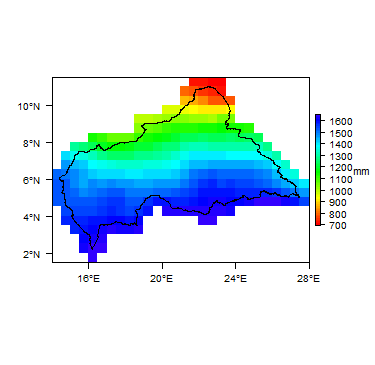 Average Annual Precipitation
 -
 Average Temperature


For further detail on the climate datasets used see the climate resources section.
Surface water
|
The north of the country is part of the Lake Chad basin, with sometimes ephemeral rivers draining to the Chari and the Logone, both of which flow into Chad and to Lake Chad. The south is part of the Congo basin, and the main rivers are the Obangui and the Sangha, and their tributaries, which are largely perennial. |
 |
Soil
|
Most soils are plinthosols, ferrasols or arenosols, with some acrisols.  |
Land cover
|
The south of the country is dominated by evergreen tropical forest. Much of the central part of the country is dominated by decidous forest and grassland. In the north, the dominant land cover is mostly shrubland. |
 |
Geology
This section provides a summary of the geology of the Central African Republic. More information is available in the report ‘Groundwater in North and West Africa’ (1988) (see References section, below).
The geology map shows a simplified version of the geology at a national scale (see the Geology resources page for more details).

Summary
Most of the country is underlain by crystalline metamorphic Precambrian basement rocks of the African shield.
Younger rocks cover only about a quarter of the country, mainly in the west and north, and smaller areas in the far south. They include Mesozoic sandstone formations; Tertiary sandstone formations; and Quaternary lacustrine and alluvial deposits.
| Key Formations | Period | Lithology | |
| Quaternary unconsolidated | |||
|---|---|---|---|
| Lacustrine and alluvial deposits | Quaternary | Neo-Chadian (part of the Lake Chad basin series) formations of lacustrine origin with thick layers of recent clays. Alluvium in river valleys. Deposits in the depressions and swampy areas of the Sangha basin. | |
| Mesozoic-Cenozoic sedimentary | |||
| Tertiary | Banbio sandstone | In the north are ferruginous sandstones, sands and cuirasses forming the edge of the Lake Chad basin.
In the south are silicified sandstones, sands and loess of the Congo basin, including the Banbio sandstone. | |
| Mesozoic | Carnot and Mouka Ouadda sandstones | Thick continental sedimentary sandstones sequences resting in angular disconformity on the basement complex. | |
| Crystalline Basement | |||
| Intrusive rocks | Precambrian | Discontinuous eruptive formations, including large masses of batholithic granite (e.g. the Bouar plateau and Mt Yade) and doloritic veins (e.g. upstream of Bangui and Nola region). | |
| Upper Precambrian | Not extensively metamorphosed. These rocks overlie the base complex and are subdivided into three units:
- an upper unit with a series of schists, quartzites, limestones and sandstones; - a middle unit consisting mainly of carbonate formations with a glacial conglomerate at the base; and - a lower unit represented by quartzites alternating with sericitic schists. | ||
| Metamorphic rocks | Lower Precambrian | A base complex subdivided into two groups: an upper group formed of quartzites and schists; and a lower group formed of gneisses, micaschists, amphibolites, granulites, migmatites and anatectic granites. | |
Hydrogeology
This section provides a summary of the hydrogeology of the main aquifers in the Central African Republic. More information is available in the report ‘Groundwater in North and West Africa’ (1988) (see References section, below).
The hydrogeology map shows a simplified version of the type and productivity of the main aquifers at a national scale (see the Aquifer properties resource page for more details).


Unconsolidated
| Named Aquifers | Period | General Description | Water quality |
Sedimentary - Intergranular Flow
| Named Aquifers | Period | General Description | Water quality |
Sedimentary - Intergranular & Fracture Flow
| Named Aquifers | Period | General Description | Water quality |
Sedimentary - Fracture Flow
| Named Aquifers | Period | General Description | Water quality |
Basement
| Named Aquifers | Period | General Description | Water quality |
Groundwater Status
Groundwater quantity
Groundwater quality
Groundwater use and management
Groundwater use
Groundwater management
Groundwater monitoring
Transboundary aquifers
For further information about transboundary aquifers, please see the Transboundary aquifers resources page
References
The following references provide more information on the geology and hydrogeology of the Central African Republic.
These, and others, can be accessed through the Africa Groundwater Literature Archive EDIT THE LINK TO CORRECT COUNTRY!!
United Nations. 1988. Groundwater in North and West Africa: Central African Republic. United Nations Department of Technical Cooperation for Development and Economic Commission for Africa. Natural Resources/Water Series No.18, ST/TCD/5.
Return to the index pages
Africa Groundwater Atlas >> Hydrogeology by country >> Hydrogeology of the Central African Republic