Hydrogeology of Botswana
Africa Groundwater Atlas >> Hydrogeology by country >> Hydrogeology of Botswana
The textual information on this page was taken from a number of different sources, which are listed in the References section, below. If you have more information on the hydrogeology of Botswana, please get in touch.
Authors
Dr Kirsty Upton and Brighid Ó Dochartaigh, British Geological Survey, UK
Geographical Setting

General
Botswana is a land-locked country. It is predominantly flat, forming a gently rolling plateau with an average elevation of 1,100 m. Up to 70 percent of the country - most of the centre, west and south - is covered by the Kalahari Desert. In the northwest is the Okavango Delta.
| Estimated Population in 2013* | 2,011,100 |
| Rural Population (% of total) (2013)* | 43.1% |
| Total Surface Area* | 566,730 sq km |
| Agricultural Land (% of total area) (2012)* | 45.7% |
| Capital City | Gabarone |
| Region | Southern Africa |
| Border Countries | South Africa, Namibia, Zimbabwe, Zambia |
| Annual Freshwater Withdrawal (2013)* | 194 Million cubic metres |
| Annual Freshwater Withdrawal for Agriculture (2013)* | 41.2% |
| Annual Freshwater Withdrawal for Domestic Use (2013)* | 40.1% |
| Annual Freshwater Withdrawal for Industry (2013)* | 18.0% |
| Rural Population with Access to Improved Water Source (2012)* | 92.8% |
| Urban Population with Access to Improved Water Source (2012)* | 99.3% |
* Source: World Bank
Climate
Botswana’s climate is mostly semi-arid. Rainfall is low - less than 250 mm/year over most of the country, and less than 100 mm/year in the Kalahari - and is unevenly distributed and highly variable from year to year. Drought is a recurrent phenomenon. The east and north of the country receive the highest rainfall, but very few areas receive more than 600 mm/year.
Potential evaporation is around 2,000 mm/year (United Nations 1989).
-
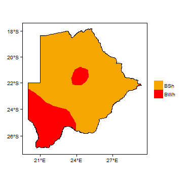 Koppen Geiger Climate Zones
 -
 Average Annual Precipitation
 -
 Average Temperature


For further detail on the climate datasets used see the climate resources section.
Surface water
|
Many rivers in Botswana are ephemeral, flowing only during wet seasons. The major perennial river systems in the north of the country are the Chobe river, which is a tributary of the Zambezi river, and flows north into Zambia; and the Okavango river, which drains into the Okavango Delta. The east of Botswana lies in the Limpopo river basin, and a number of tributaries in Botswana flow into the Limpopo river. The Notwane river in the south provides water to the capital city through the Gabarone Dam. The Molopo river forms the border with South Africa to the south. There are a number of dams in the country.
|
 |
Soil
|
Much of the country is covered with arenosols typical of arid, desert areas. Only in the east is there widespread development of other soil types.
 |
Land cover
| Up to 70 percent of the country is covered by the Kalahari Desert, with grassland and savannah vegetation that is often sparse. The east of the country has more forest cover. The northwest of Botwana lies in the Okavango Delta, with extensive wetlands.
|
 |
Geology
This section provides a summary of the geology of Botswana. More information is available in the Africa Groundwater Literature Archive.
The geology maps below show a simplified version of the geology at a national scale (see the Geology resources page for more details).


Summary
Much of Botswana is covered by unconsolidated sediments of Tertiary to Quaternary age, related to the Kalahari Desert, and known as the Kalahari system.
The pre-Kalahari geology of the country includes sedimentary rocks - largely sandstones - of Karoo type, sometimes capped by volcanic rocks; and large areas of Precambrian rocks. The Precambrian rocks are divided into sedimentary basins, which are also sometimes capped with volcanic rocks; dolomites; and basement type crystalline rocks.
Botswana is rich in mineral resources, including coal, diamonds, and metals such as nickel and copper.
| Key Formations | Period | Lithology | |
| Kalahari | |||
|---|---|---|---|
| Kalahari | Tertiary to Quaternary | Aeolian and alluvial sands and gravels up to 40 m thick. | |
| Karoo system | |||
| Karoo | The Karoo system includes the Stormberg Group, Ecca Group and Dwyka Group.
| ||
| Precambrian | |||
| Metasedimentary basins | |||
| Dolomites | |||
Hydrogeology
This section provides a summary of the hydrogeology of the main aquifers in Botswana. More information is available in the Africa Groundwater Literature Archive.
The hydrogeology map shows a simplified version of the type and productivity of the main aquifers at a national scale (see the Aquifer properties resource page for more details).

Unconsolidated
| Named Aquifers | Period | General Description | Water quality |
| Kalahari system | Tertiary - Quaternary | Aeolian and alluvial sands and gravels. |
Sedimentary - Intergranular Flow
| Named Aquifers | Period | General Description | Water quality |
Sedimentary - Intergranular & Fracture Flow
| Named Aquifers | Period | General Description | Water quality |
| Karoo system | The Karoo system forms a stratified aquifer, in which permeable layers (dominantly sandstone) are separated by layers with low permeability. A large proportion of groundwater storage and flow is via fractures in the aquifer layers. Semi-vertical fault zones and fractures form some connection between aquifer layers. The highest potential aquifers within the Karoo system are fractured sandstones with high transmissivity and storage capacity, particularly the Ecca and Cave sandstones. |
Sedimentary - Fracture Flow (including karstic)
| Named Aquifers | Period | General Description | Water quality |
| Dolomites | Precambrian | These rocks form karstic aquifers. | |
| Volcanic rocks | |||
| Metasedimentary rocks | Precambrian | Quartzites can have moderately high yields |
Basement
| Named Aquifers | Period | General Description | Water quality |
| Precambrian | Weathered basins...
Low storage capacity and generally small yields; occasional large yields |
Groundwater Status
There have been a number of estimates of the volume of Botswana’s groundwater resources. One puts the total groundwater resource at around 100 billion m³, with an average annual recharge of 1,600 million m³/year (Department of Surveys and Mapping, Government of Botswana, 2001); another gives a much lower estimated sustainable yield of 96 million m³/year. These different figures illustrate that further groundwater exploration work is needed to estimate the sustainable amount of groundwater in the country (Department of Water Affairs, Ministry of Minerals, Energy & Water Resources, 2013)
Only a small part of the estimated available groundwater resources can be economically abstracted, due to high abstractions costs, poor water quality and remoteness of productive aquifers in relation to water demand (Department of Water Affairs, Ministry of Minerals, Energy & Water Resources, 2013).
Groundwater use and management
Groundwater use
Groundwater is abstracted mostly for use in rural water supply, mines, power plants and irrigation, through well fields and individual boreholes.
Groundwater management
Groundwater monitoring
Transboundary aquifers
For further information about transboundary aquifers, please see the Transboundary aquifers resources page
References
The following references provide more information on the geology and hydrogeology of Botswana.
Many of these, and others, can be accessed through the Africa Groundwater Literature Archive
Useful web resources
Department of Surveys and Mapping, Government of Botswana. The Botswana National Atlas
Published literature
Department of Water Affairs, Ministry of Minerals, Energy & Water Resources. 2013. Botswana Integrated Water Resources Management & Water Efficiency Plan, Volume 1: Main Report. (L. Dikobe, Ed), Gabarone, Botswana: Government of Botswana.
United Nations. 1989. Groundwater in Eastern, Central and Southern Africa: Botswana. United Nations Department of Technical Cooperation for Development. Natural Resources / Water Series No. 19, ST/TCD/6
Return to the index pages
Africa Groundwater Atlas >> Hydrogeology by country >> Hydrogeology of Botswana