Hydrogeology of Senegal
Africa Groundwater Atlas >> Hydrogeology by country >> Hydrogeology of Senegal
Authors
Dr Diakher Hélène Madioune, Cheikh Anta Diop University, Senegal
Ibrahima Mall, Cheikh Anta Diop University, Senegal
Moctar Diaw, Cheikh Anta Diop University, Senegal
Professor Serigne Faye, Cheikh Anta Diop University, Senegal
Emily Crane, Kirsty Upton, Brighid Ó Dochartaigh, British Geological Survey, UK
Please cite this page as: Madioune, Mall, Diaw, Faye, Crane, Upton & Ó Dochartaigh, 2016.
Bibliographic reference: Madione, D.H., Mall, I., Faye, S., Crane, E., Upton, K. & Ó Dochartaigh, B.É. 2016. Africa Groundwater Atlas: Hydrogeology of Senegal. British Geological Survey. Accessed [date you accessed the information]. http://earthwise.bgs.ac.uk/index.php/Hydrogeology_of_Senegal
Terms and conditions
The Africa Groundwater Atlas is hosted by the British Geological Survey (BGS) and includes information from third party sources. Your use of information provided by this website is at your own risk. If reproducing diagrams that include third party information, please cite both the Africa Groundwater Atlas and the third party sources. Please see the Terms and Conditions for more information.
Geographical Setting

General
| Estimated Population in 2013* | 14133280 |
| Rural Population (% of total)* | 56.92% |
| Total Surface Area* | 192530 sq km |
| Agricultural Land (% of total area)* | 46.82% |
| Capital City | Dakar |
| Region | Western Africa |
| Border Countries | Gambia, Guinea-Bissau, Guinea, Mali, Mauritania |
| Annual Freshwater Withdrawal (2013)* | 2.611 Million cubic metres |
| Annual Freshwater Withdrawal for Agriculture* | 92.98% |
| Annual Freshwater Withdrawal for Domestic Use* | 4.412% |
| Annual Freshwater Withdrawal for Industry* | 2.611% |
| Rural Population with Access to Improved Water Source* | 60.3% |
| Urban Population with Access to Improved Water Source* | 92.5% |
* Source: World Bank
Climate
These maps and graphs were developed from the CRU TS 3.21 dataset produced by the Climatic Research Unit at the University of East Anglia, UK. For more information see the climate resource page.
-
 Koppen Geiger Climate Zones
 -
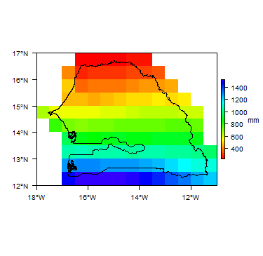 Average Annual Precipitation
 -
 Average Temperature


Temporal variations in temperature and rainfall. Rainfall time-series and graphs of monthly average rainfall and temperature for each individual climate zone can be found on the Senegal Climate Page.


Surface water
The following institutions have responsibilities for surface water in Senegal:
|
 |
Soil
 |
Land cover
 GeologyThis section provides a summary of the geology of Senegal. More detail can be found in the references listed at the bottom of this page. Many of these references can be accessed through the Africa Groundwater Literature Archive. The geology map on this page shows a simplified overview of the geology at a national scale (see the Geology resource page for more details). 
HydrogeologyThis section provides a summary of the hydrogeology of the main aquifers in Senegal. More information is available in the references listed at the bottom of this page. Many of these references can be accessed through the Africa Groundwater Literature Archive. The hydrogeology map on this page shows a simplified overview of the type and productivity of the main aquifers at a national scale (see the Hydrogeology map resource page for more details).  Superficial: Unconsolidated
Cretaceous - Tertiary Sedimentary - Intergranular and Fracture Flow
Key references for information on these aquifers: Faye S, Faye SC, Ndoye S and Faye A. 2003. Hydrogeochemistry of the Saloum (Senegal) superficial coastal aquifer. Env Geo 44 (2):127–136 Diaw M, Faye S, Stichler W and Maloszewski P. 2012. Isotopic and geochemical characteristics of groundwater in the Senegal River delta aquifer: implication of recharge and flow regime. Environ Earth Sci DOI: 10.1007/s12665-010-0710-4. Diaw M. 2008. Approches hydrochimique et isotopique de la relation eau de surface/nappe et du mode de recharge de la nappe alluviale dans l’estuaire et la basse vallée du fleuve Sénégal: Identification des zones inondées par Télédétection et par traçage isotopique; Thèse, Univ. C. A. Diop de Dakar. Dakar, Sénégal, pp. 210. Re V Cissé, Faye S, Faye A, Faye S, Gaye CB, Sacchi E and Zuppi GM. 2010. Water quality decline in coastal aquifers under anthropic pressure: the case of a suburban area of Dakar (Senegal). Environmental Monitoring Assessment. DOI 10.1007/s10661-010-1359-s. Sall M and Vanclooster M. 2009. Assessing the well water pollution problem by nitrates in the small scale farming systems of the Niayes region (Senegal). Agricultural Water Management, 96: 1360–1368. Gueye-Girardet A. 2010. Evaluation des pratiques d’irrigation, de fertilisation et d’application de pesticides dans l’agriculture périurbaine de Dakar, Sénégal. Thèse de Doctorat, Université de Lausanne, 276p. Tandia AA, Diop ES and Gaye CB. 1999. Nitrate groundwater pollution in suburban areas: example of groundwater from Yeumbeul, Senegal. Journal of African Earth Sciences, 29(4): 809-822.
Basement: Hercynian-Panafrican and Birimian
Key references for information on these aquifers: COWI. 2000. Etude Hydrogéologique de la Nappe Profonde du Maastrichtien. Service de Gestion et de Planification des Ressources en Eau (SGPRE) Diouf S. 1999. Hydrogéologie en zone de socle cristallin et cristallophyllien du Sénégal Oriental. Application de la méthode électrique 1D et 2D à la localisation et à la caractérisation des aquifères du batholite de Saraya et ses environs. Thèse de doctorat de 3e cycle. Université Cheikh Anta Diop de Dakar, 86 p. + annexes. Mall I. 2009. Contribution à l’étude hydrogéochimique en zone de socle: cas du Sénégal Oriental. Mémoire de DEA de l’Université Cheikh Anta Diop, 81p. Wuilleumier A, Théveniaut H, Mall I et Ndiaye PM. 2010. Notice explicative de la carte hydrogéologique à 1/500 000 du Sénégal oriental, Ministère des Mines, de l’Industrie, de l’Agro-Industrie et des PME, Direction des Mines et de la Géologie, Dakar. Groundwater StatusGroundwater QuantitySenegal has significant groundwater resources but the distribution of availability and demand do not match. This means that some groundwater systems are over exploited, leading to groundwater depletion: this has been observed in the Palaeocene and Maastrichtian in the Diass aquifer system. Groundwater QualitySaline intrusion The shallow river delta aquifer and the Saloum superficial aquifer in Senegal have been affected by seawater intrusion as far as, respectively, 200 km and 100 km inland, with wells adjacent to the rivers reporting salt concentrations as high as 10 g/L in the Senegal delta (Diaw et al. 2012) and 3 g/L in Saloum (Faye et al. 2003). The whole coastline (1,700 km) of Senegal and the deep Maastrichtian aquifer have been also highly affected by seawater intrusion. In the western part, the deep Maastrichtian aquifer is characterized by the presence of salt water depth or true "brine" with concentrations above 100 g/l. The interface limit of fresh and salt waters is very variable, which makes it difficult to estimate the volume and water flow direction. Soil and shallow groundwater salinity Large-scale irrigation in alluvial valleys (Senegal, Saloum and Casamance) may also act to gradually increase the salinity levels in soil water, surface water systems and/or aquifers. This is because the crops transpire almost pure water, which means that applied irrigation leaves a residue of dissolved substances. The effects are most pronounced under arid conditions but also with the use various anthropogenic pollutants (fertilizers, domestic, industrial and agricultural effluents etc). In addition, the using brackish water or treated waste waters for irrigation in Niayes area (north coastline) may promote salinization of the underlying groundwater system in particularly around of large cities like Dakar. It is assumed that the groundwater salinization because of irrigation is restricted to the first meters to tens of meters below the groundwater table in sands dunes (Niayes area). Groundwater salinization effects of these processes will be rather localised. Agricultural and industrial contaminants In Senegal, agricultural and industrial activities affect the quality of surface water and groundwater that undergo also strong alteration due to chemical pollution from industrials effluents and used products in agriculture including pesticides and fertilizers. This depends on several factors: soil characteristics, irrigation, crops performed, regulation deficiencies, illiteracy of farm operators and funding facility of chemical inputs. These are sensitive problems in areas such as Senegal River Delta, Dakar, Mbour and Fatick etc. The studies carried out in the Senegal delta showed that the river and distributaries channels are affected by mineral pollution from private irrigation discharges in the alluvial plain of Djeuss, pumping stations discharges of Ndong and Gaela on the Gorom channel and high mineralized drainage water discharge of sugar company in Guiers Lake (Diaw 2008). The presence of dangerous herbicides or insecticide residues were detected in the analysis carried at several locations in Guiers Lake and in the alluvial aquifer. Other anthropogenic contaminants In addition to these phenomena mentioned above, other factors may cause water quality degradation, especially in alluvial and coastal unconfined aquifers that are most vulnerable. These shallow groundwaters have been contaminated by anthropogenic pollution in Dakar city and suburbs, most likely a consequence of high population growth, uncontrolled land use and poor hygiene and lack sanitation of the people. Pollution is shown by the presence of nitrates and organic micro-pollutants and bacteriological contamination. Groundwater pollution by nitrates in Dakar region, is important particularly at Mbeubeuss discharge in the Pikine-Thiaroye area, but also occurs in outcropping groundwaters in the Dakar slums (Dalifor, Medina-Gounass). The nitrogen concentrations are increasing in shallow groundwater (sometime to over 400 mg/L) and several studies have been carried out to characterize the problem of nitrate pollution in groundwater in the Dakar Region (Cisse Faye 2013, Diédhiou et al. 2011; Re et al. 2010; Sall & Vanclooster 2009; Gueye-Girardet 2010; Tandia et al. 1999). Groundwater Dependent EcosystemsSenegal has areas known as 'niayes' ,which are depressions between dunes which have a very shallow groundwater level. These are common in the Niayes region of northwest Senegal. These areas are prone to groundwater depletion. Mangrove forests occur in the Saloum and Casamance estuaries. Groundwater use and managementGroundwater useAbout 60% of Dakar's drinking water is supplied from groundwater, obtained from the Cretaceous-Tertiary Intermediate and Deeper aquifers. Groundwater is also used elsewhere for drinking water, industry and agriculture, abstracted largely from basement aquifers. Abstraction from the Intermediate and Deeper aquifer systems is from boreholes with electric pumps, while hand pumps are more common in the basement areas. Groundwater managementGroundwater and surface water management in Senegal, including water policy, are the responsibility of the Direction de la Gestion et de la Planification des Ressources en Eau (DGPRE). Permits are required for drilling and water abstraction. Currently, there is no legislative protection for groundwater in vulnerable areas, and water disposal is not controlled. Data show that in 2008 there were at least 7000 recorded groundwater sources in Senegal, both boreholes and large diameter (hand dug) wells, with geological log information for about 1400 of the boreholes. Groundwater monitoringGroundwater levels Groundwater levels are monitored twice a year: before and after the rainy season. This work is funded through the Ministry of Hydraulics and Sanitation. Groundwater quality Groundwater quality is measured twice per year, before and after the rainy season, funded by the Ministry of Hydraulics and Sanitation. This work is sometimes extended by NGOs, researchers or others who want to better understand water quality. These data are collected and stored by the Direction de la Gestion et de la Planification des Ressources en Eau (DGPRE) and the Société Nationale des Eaux du Sénégal (SONES). Transboundary aquifersThe Deeper aquifer system of the Maastrichtian is a transboundary aquifer, which is shared by Senegal, Gambia, Mauritania and Guinea-Bissau but there is no specific management issue. For links to further information about transboundary aquifers, please see the Transboundary aquifers resources page ReferencesMany of the references below, and others relating to the hydrogeology of Senegal, can be seen in the African Groundwater Literature Archive. Key Geology ReferencesRoger J, Noël BJ, Barusseau JP, Serrano O, Nehlig P and Duvail C. 2009. Notice explicative de la carte géologique du Sénégal à 1/500 000, feuilles nord-ouest, nord-est et sud-ouest. Ministère des Mines, de l’Industrie et des PME, Direction des Mines et de la Géologie, Dakar, 61 pages. Roger J, Duvail C, Barusseau JP, Noël BJ, Nehlig P and Serrano O. 2009. Carte géologique du Sénégal à 1/500 000, feuilles nord-ouest, nord-est et sud-ouest. Ministère des Mines, de l’Industrie et des PME, Direction des Mines et de la Géologie, Dakar, 3 coupures. Théveniaut H, Ndiaye PM, Buscail F, Couëffé R, Delor C, Fullgraf T and Goujou J-C. 2010. Notice explicative de la carte géologique du Sénégal oriental à 1/500 000. Ministère des Mines, de l’Industrie, de l’Agro-Industrie et des PME, Direction des Mines et de la Géologie, Dakar Key Hydrogeology ReferencesCowi-Polyconsult. 1998-2002. Etude hydrogéologique de la nappe profonde du Maastrichtien,Sénégal. Rapps. Cowi-Polyconsult, Rép. Sénég., Min. Hydrau. Roger J, Banton O, Barusseau JP, Castaigne P, Comte J-C, Duvail C, Nehlig P, Noël BJ, Serrano O and Travi Y. 2009. Notice explicative de la cartographie multi-couches à 1/50 000 et 1/20 000 de la zone d’activité du Cap-Vert. Ministère des Mines, de l’Industrie et des PME, Direction des Mines et de la Géologie, Dakar, 245 pages. Wuilleumier A, Théveniaut H, Mall I et Ndiaye PM. 2010. Notice explicative de la carte hydrogéologique à 1/500 000 du Sénégal oriental, Ministère des Mines, de l’Industrie, de l’Agro-Industrie et des PME, Direction des Mines et de la Géologie, Dakar.
Return to the index pagesAfrica Groundwater Atlas >> Hydrogeology by country >> Hydrogeology of Senegal |
||||||||||||||||||||||||||||||||||||||||||||||||||||||||||||||||||||||||||||||||||||||||||||||||||||||||||||||||||||||||||||||