Hydrogeology of Libya
Africa Groundwater Atlas >> Hydrogeology by country >> Hydrogeology of Libya
This page has limited information and needs to be updated. If you have more information on the hydrogeology of Libya, please get in touch!
Compilers
Dr Kirsty Upton and Brighid Ó Dochartaigh, British Geological Survey, UK
Please cite this page as: Upton & Ó Dochartaigh, 2016.
Bibliographic reference: Upton, K. & Ó Dochartaigh, B.É. 2016. Africa Groundwater Atlas: Hydrogeology of Libya. British Geological Survey. Accessed [date you accessed the information]. http://earthwise.bgs.ac.uk/index.php/Hydrogeology_of_Libya
Terms and conditions
The Africa Groundwater Atlas is hosted by the British Geological Survey (BGS) and includes information from third party sources. Your use of information provided by this website is at your own risk. If reproducing diagrams that include third party information, please cite both the Africa Groundwater Atlas and the third party sources. Please see the Terms of use for more information.
Geographical Setting

General
| Capital city | Tripoli |
| Region | Northern Africa |
| Border countries | Egypt, Sudan, Chad, Niger, Algeria, Tunisia |
| Total surface area* | 2,000,000 km2 ( 200,000,000 ha) |
| Total population (2015)* | 6,278,000 |
| Rural population (2015)* | 1,316,000 (21%) |
| Urban population (2015)* | 4,962,000 (79%) |
| UN Human Development Index (HDI) [highest = 1] (2014)* | 0.7245 |
* Source: FAO Aquastat
Climate
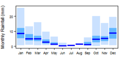
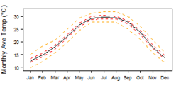
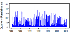
More information on average rainfall and temperature for each of the climate zones in Libya can be seen at the Libya climate page.
These maps and graphs were developed from the CRU TS 3.21 dataset produced by the Climatic Research Unit at the University of East Anglia, UK. For more information see the climate resource page.
Surface water
|
There are no permanent rivers in Libya, only ephemeral rivers or wadis. There are several natural desert lakes, which support unique ecosystems and provide a water supply to desert nomads and migrating animals (Abufayed et al. 2015). The main lakes are the Ubari lakes in the Ubari Sand Sea in the south, including the Gaberoun, Mandara and Mafo akes–, the protected Ouau en Namu lakes and the 23rd of July or Benghazi lake, which is more properly a lagoon. The Qattara Depression in the north-west of Libya lies under the sea level and is covered with temporary lakes, salt pans and salt marshes. Other large salt pans include Sabkhat al Hayshah close to the coast near the gulf of Sidra, and Sabkhat Shunayn and Ghuzayyil in the north-east. |
 |
Soil
 |
Land cover
 |
Water statistics
| 2000 | 2001 | 2012 | 2014 | 2015 | |
| Rural population with access to safe drinking water (%) | 68.3 | ||||
| Urban population with access to safe drinking water (%) | 72.1 | ||||
| Population affected by water related disease (per 1000 inhabitants) | No data | No data | No data | No data | No data |
| Total internal renewable water resources (cubic metres/inhabitant/year) | 111.5 | ||||
| Total exploitable water resources (Million cubic metres/year) | 635 | ||||
| Freshwater withdrawal as % of total renewable water resources | 822.9 | ||||
| Renewable groundwater resources (Million cubic metres/year) | 600 | ||||
| Groundwater produced internally (Million cubic metres/year) | 600 | ||||
| Fresh groundwater withdrawal (primary and secondary) (Million cubic metres/year) | 5.55 | ||||
| Groundwater: entering the country (total) (Million cubic metres/year) | 0 | ||||
| Groundwater: leaving the country to other countries (total) (Million cubic metres/year) | 700 | ||||
| Industrial water withdrawal (all water sources) (Million cubic metres/year) | 280 | ||||
| Municipal water withdrawal (all water sources) (Million cubic metres/year) | 700 | ||||
| Agricultural water withdrawal (all water sources) (Million cubic metres/year) | 4,850 | ||||
| Irrigation water withdrawal (all water sources) (Million cubic metres/year) | No data | No data | No data | No data | No data |
| Irrigation water requirement (all water sources) (Million cubic metres/year) | 1.833 | ||||
| Area of permanent crops (ha) | 300,000 | ||||
| Cultivated land (arable and permanent crops) (ha) | 2,050,000 | ||||
| Total area of country cultivated (%) | 1.165 | ||||
| Area equipped for irrigation by groundwater (ha) | 464,000 | ||||
| Area equipped for irrigation by mixed surface water and groundwater (ha) | No data | No data | No data | No data | No data |
These statistics are sourced from FAO Aquastat. More information on the derivation and interpretation of these statistics can be seen on the FAO Aquastat website.
Further water and related statistics can be accessed at the Aquastat Main Database.
1 More information on irrigation water use and requirement statistics
Geology
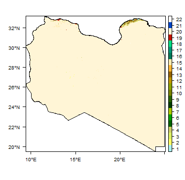
The geology map on this page shows a simplified version of the geology at a national scale (see the Geology resource page for more details).
|
|
 |
Hydrogeology
The hydrogeology map below, at 1:5 million scale, shows the type and productivity of the main aquifers at a national scale (see the Hydrogeology map resource page for more details).
More information on the hydrogeology of Libya is available in the report United Nations (1988) (see References section, below).
Transboundary aquifers
For further information about transboundary aquifers, please see the Transboundary aquifers resources page.
References
References with more information on the geology and hydrogeology of Libya can be accessed through the Africa Groundwater Literature Archive.
Abdudayem A and Scott AHS. 2014. Water infrastructure in Libya and the water situation in agriculture in the Jefara region of Libya. African Journal of Economic and Sustainable Development, 3 (1).
Abufayed A, Madi L and Radi M. 2015. Libya State of the Water Reporting, Monitoring and Evaluation Operational Framework and Guidelines. Report for CEDARE.
Sattar AMA and Gawad SA. 2014. North Africa Regional Water Sector M&E Rapid Assessment Report. Report for CEDARE.
United Nations. 1988. Groundwater in North and West Africa: Libya. United Nations Department of Technical Cooperation for Development and Economic Commission for Africa.
Return to the index pages
Africa Groundwater Atlas >> Hydrogeology by country >> Hydrogeology of Libya


