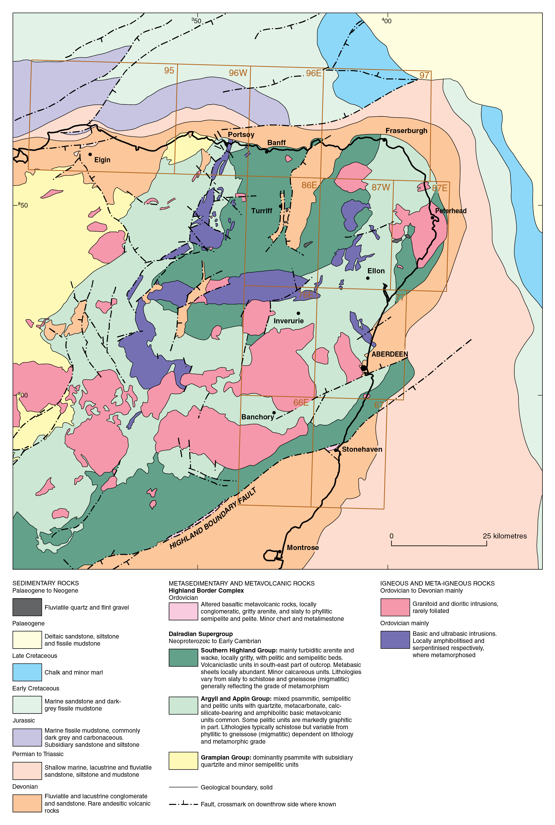
Banffshire Coast Drift Group, Quaternary lithostratigraphy, Cainozoic of north-east Scotland
| Merritt, J W, Auton, C A, Connell, E R, Hall, A M, and Peacock, J D. 2003. Cainozoic geology and landscape evolution of north-east Scotland. Memoir of the British Geological Survey, sheets 66E, 67, 76E, 77, 86E, 87W, 87E, 95, 96W, 96E and 97 (Scotland).
Contributors: J F Aitken, D F Ball, D Gould, J D Hansom, R Holmes, R M W Musson and M A Paul. |
Banffshire Coast Drift Group
This group of deposits contains clasts derived from the Moray Firth basin in addition to more locally occurring rock types. They occur from Inverness eastwards towards Peterhead (P915251). The diamictons, silts and clays are typically dark grey, calcareous and contain ice-worn Quaternary shell fragments in addition to abundant reworked Early Jurassic to Early Cretaceous microfossils. Permo–Triassic and Lower Jurassic to Upper Cretaceous strata crop out within the Moray Firth basin (BGS, 1977) and both clasts and large glacial rafts of these rock types are common in the tills of this group. Locally, both the colour and composition of the tills stongly reflect the lithology of the underlying bedrock. The sands and gravels generally contain similar suites of clasts within the tills, and shell fragments are common.
Till

The most distinctive tills of the Banffshire Coast Drift Group are bluish grey in colour, clayey and contain erratics and rafts of Mesozoic rocks and Quaternary sea floor sediments derived from the Moray Firth basin, together with reworked fossils and shell fragments. They have a discontinuous distribution at the surface and some older units occur at depth interbedded with deposits of the other groups (P915251; P915347). Though it has long been concluded that most of these bluish grey diamictons were deposited by ice moving landwards from the Moray Firth basin (Jamieson 1906; Read, 1923; Bremner, 1928, 1934), direct evidence for such ice movement, such as striations or clast fabric measurements, are rare. Furthermore, there has been little consensus concerning when, and how many times, ice moved onshore to produce these distinctive deposits.
Whitehills Glacigenic Formation

Blue-grey diamictons occur widely, but not extensively near, or at, the surface between Elgin, Peterhead and Ellon. Most of them probably belong to one laterally discontinuous, allostratigraphical unit, the Whitehills Glacigenic Formation (Peacock and Merritt, 1997, 2000). The formation is generally capped by brown, red or grey till containing clasts derived from the west or west-northwest (Jamieson, 1906; Read, 1923; Peacock et al., 1968; Aitken et al., 1979; Hall et al., 1995a) and is almost certainly of Late Devensian age (Peacock and Merritt, 1997, 2000). It is named after the village lying 4 km to the west of the type section in the Boyne Limestone Quarry (NJ 612 658) on Sheet 96W Portsoy (P915372; Boyne Bay, Gardenstown and King Edward).


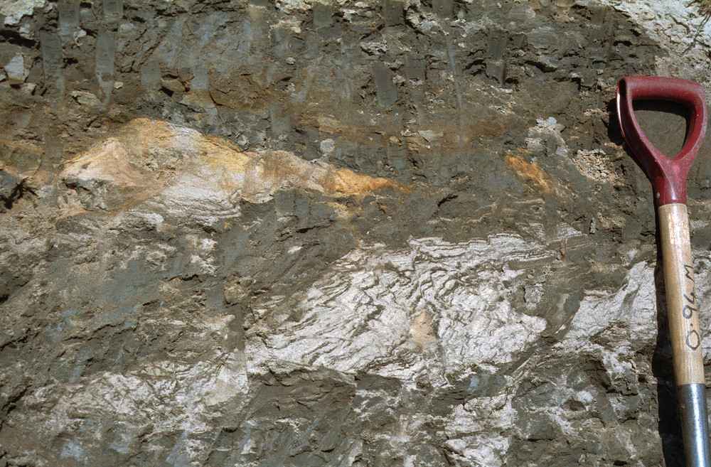
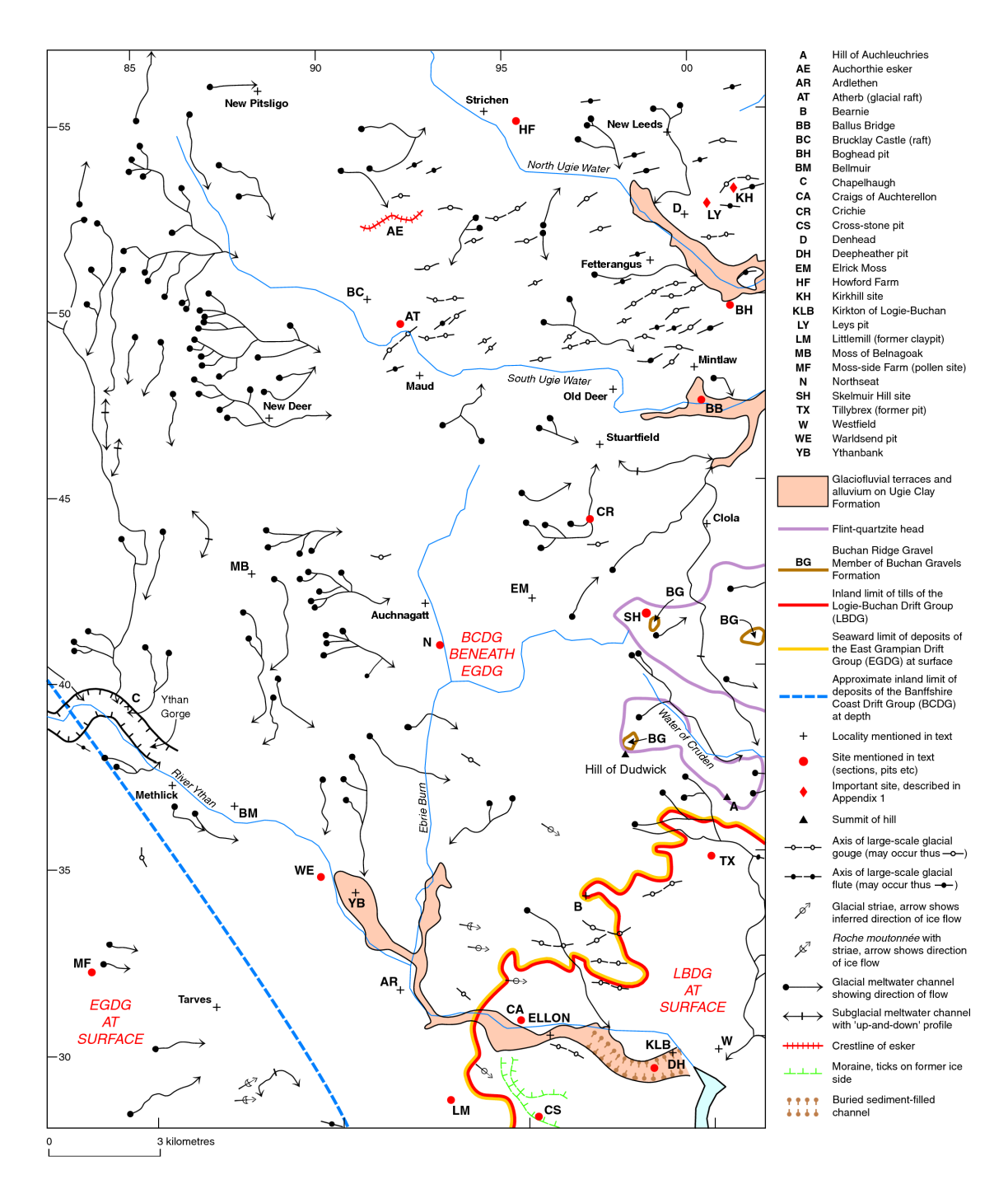
The Whitehills Glacigenic Formation is notable for its inclusion of a relatively large proportion of glacial rafts of Mesozoic strata and Quaternary sediments derived from the Moray Firth basin (P104124). The rafts include mudstones, friable sandstones, clays, silts, sands and gravels. Jurassic material predominates in the west, whereas some Lower Cretaceous rocks and fossils are also present in the east. Some rafts crop out at the surface and are large enough to be mapped out individually on Sheet 96W and Sheet 96E, such as the one at Whitehills itself (P915373), which has been largely removed for making bricks and tiles. A ‘blue oolite clay’ with striated stones, probably a till including rafts of clay, was formerly worked at Lumbs (NK 028 578) (Milne, 1892a), on Sheet 97 (P915374), and further occurrences of locally shelly ‘blue clay’ have been reported to the south and west of Fraserburgh (Jamieson 1906). Large Jurassic erratics were formerly exposed at Atherb and Brucklay Castle, to the south-west of Strichen (P915376; Jamieson, 1906) and around Plaidy and Turriff (P915375; Read, 1923). Dark grey to black till, locally shelly, has been recorded at depth at several localities in the catchment of the River Ugie (McMillan and Aitken, 1981). There are few exposures, but at the time of writing several rafts could be seen in a quarry at Ardglassie (NK 012 617), 5 km south-south-east of Fraserburgh, and others were exposed at the Oldmill site (P104119).


Several other units of blue-grey till that have been recognised in the district may correlate with the White-hills Glacigenic Formation (P915347). For example, in the valley of the Red Burn, south of Fochabers, Hall et al. (1995a) reported a dark till (Altonside Till) with Mesozoic erratics and a fabric indicating derivation from the northwest (P915371; Teindland). They correlated the Altonside Till with other dark tills recorded by Aitken et al. (1979) in the lower Spey valley. At the King Edward site (P915375), south-west of Gardenstown, stones in an unnamed unit of dark till retain striations suggesting ice movement from the west or north-west (Jamieson, 1906). Although that unit of till is apparently absent at the Howe of Byth site to the east (P915374), the Howe of Byth Gravel Formation there contains some Mesozoic erratics and might have been laid down contemporaneously with the Whitehills Glacigenic Formation. The East Leys Till that occurs between Fraserburgh and Peterhead is another correlative, although it is not overlain by younger tills (Kirkhill). It is typically decalcified to a depth of about 4 m and includes red granite, probably from the Peterhead area, and local Inzie Head Gneiss, in addition to chalk and flint. The dark grey silty clay matrix of the till contains dinoflagellate cysts of Late Jurassic to Early Cretaceous age (Hall and Jarvis, 1993a). The East Leys Till is generally thought to have been laid down during the Devensian because it lies stratigraphically above the Fernieslack Palaeosol Bed (formerly Kirkhill Upper Buried Soil, which is likely to be Ipswichian in age or older (Duller et al., 1995). The Pitlurg Till, which occurs between Ellon, Cruden Bay and the Buchan Ridge (Ellon) also includes materials that were apparently carried westwards from the North Sea basin in addition to Jurassic erratics and fossils derived from the Moray Firth (see below).
Tills overlying the Whitehills Glaciogenic Formation
At the type section of the Whitehills Glacigenic Formation in the upper part of the Boyne Limestone Quarry the shelly till and rafts are generally overlain by a unit of brown stony till containing clasts derived mainly from the west. This unit, named as the Old Hythe Till Formation (Peacock and Merritt, 2000) is correlated with the Crovie Till Formation (Peacock and Merritt, 1997) occurring at Gardenstown to the east. At both localities the contact of the brown till with deposits of the underlying Whitehills Glacigenic Formation is gradational. Furthermore, at both localities the brown tills are judged to have been laid down by ice flowing towards the east following a change of direction from the south to south-easterly movement that brought about the emplacement of the Whitehills Glacigenic Formation and its included rafts. It is apparent that the Crovie Till Formation and Old Hythe Till Formation are likely to have been laid down during the same event, but by East Grampian ice and ice from the central Grampians respectively (P915251; P915347).


A similar sequence occurs at the Oldmill site (P104119), on Sheet 87E Peterhead, where an un-named unit of brown till is tentatively correlated with the Hythie Till Formation at Kirkhill. The brown till has erratics derived from farther west and a weak ‘west to east’ fabric (Merritt and Connell, 2000). It rests on dark grey till containing rafts of Jurassic shale, Quaternary marine clay and sand (P915347). At Kirkhill, dark clay with Mesozoic erratics (Corse Diamicton) also locally underlies brown till with clasts derived from the west and southwest, the Hythie Till (formerly Kirkhill Upper Till). The former quarry at Kirkhill is situated within a drumlinoid ridge trending west–east suggesting that ice last flowed from the west. Other ice-moulded features in the area are similarly orientated (P915376). The history of events in Buchan thus appears to match that elucidated at the Boyne Limestone Quarry and Gardenstown, with ice first flowing across the area from the north-west, transporting rafts from the Moray Firth, before changing towards an easterly direction.
Essie Till Formation
Calcareous blue-grey tills occur at the surface between Rosehearty and Peterhead on Sheet 97 and Sheet 87E. Most glacial striae, ice moulded features and erratics (P915374; P915377) indicate that the last movement of ice was towards the east-south-east or south-east across the area. There is also evidence of a minor re-advance of ice from the north and east that affects a narrow coastal zone between Cairnbulg Point and St Combs (Peacock, 1997). The tills are commonly mottled grey and brown at the top and contain a variety of materials eroded from the bed of the Moray Firth. They cannot easily be distinguished lithologically from those of the Whitehills Glacigenic Formation described above, but they do not appear to have been affected by any subsequent ice movement from the west as at Boyne Bay, Gardenstown, Kirkhill and Oldmill. In the absence of overlying tills derived from inland, it is uncertain whether these coastal blue-grey tills, assigned here to the Essie Till Formation, are strictly equivalent to those of the Whitehills Glacigenic Formation (or the East Leys Till); they probably relate to a later event.


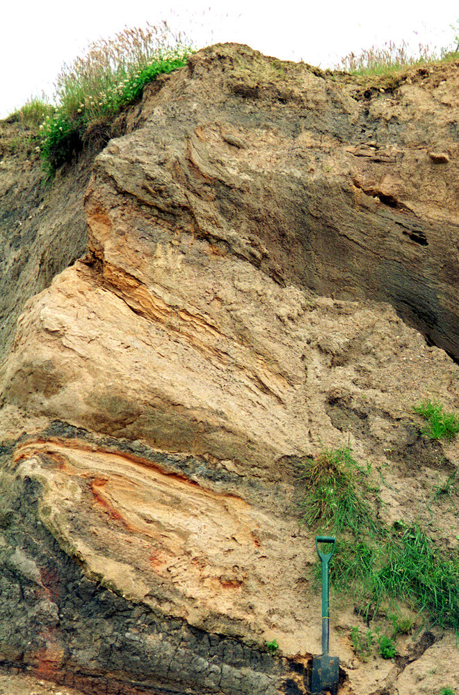
The type locality of the Essie Till Formation is around South Essie farm, near St Fergus P915377 where several pipeline trench exposures revealed more than 2.5 m of dark grey, calcareous silty clayey diamicton with shell fragments and erratics of pink granite, quartz and metasedimentary rock (M. Munro in British Geological Survey Records). The unit generally overlies a reddish brown, calcareous silty clayey diamicton that probably correlates with the Hatton Till of the Logie-Buchan Drift Group. The Essie Till Formation was also exposed in a BGS Registered trial pit NK05NW6 (NK 0280 5778) dug in the vicinity of the former Lumbs claypit (P915374) where a ‘blue oolite clay’ with striated stones was formerly worked (Milne, 1892a). The pit exposed over 3.8 m of stiff, dark grey clay and pebbly clay diamicton with lenses of reddish brown diamicton, small masses of red clay and very sparse fragments of shell and chalk. The dark diamicton contained sparse pebbles and cobbles of marl and red sandstone whereas the red diamicton contained granules of red sandstone and mudstone. The red materials and black mudstones and chalk are derived from outcrops of Permo–Triassic and Cretaceous strata lying within the Moray Firth basin to the north (P915249). The trial pit was dug into an isolated, drumlinoid hill trending northwest to south-east. Both the glacial streamlining of the feature and the composition of the till indicate ice flow towards the south-east.

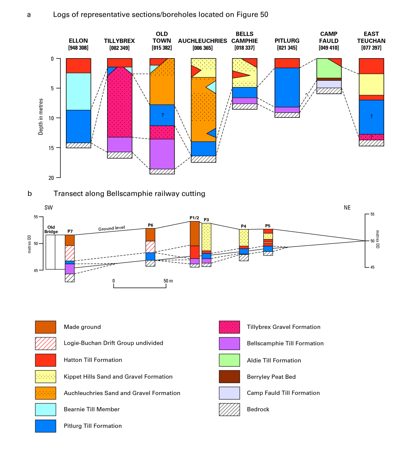
Several boreholes in an area of some 15 km2 to the north of the River Ugie, on Sheets 97 and 87E, proved dark shelly diamictons that are probably equivalent to the Essie Till Formation (McMillan and Aitken, 1981). For example, Borehole NK05SE9 drilled at Kinloch Farm (NK 0989 5093), 4 km north-west of Peterhead, proved 5.4 m of stiff, dark bluish grey pebbly clay diamicton with clasts of pink granite, quartz and schistose metasedimentary rock. As in the pipeline trenches, the underlying unit (3.2 m thick) is similar in lithology, but is dark reddish brown in colour and contains sparse boulders of granite. It rests on 9.8 m of crudely laminated, red, reddish brown and yellowish brown, micaceous silt of probable glaciolacustrine origin and equivalent to the Ugie Clay Formation of the Logie-Buchan Drift Group. Both diamictons are probably deformation tills and result from an advance of coastal ice across glaciolacustrine deposits (P915289a). The latter were laid down in lakes ponded against coastal ice after ice from inland had retreated westwards.
The clasts of pink granite in the Essie Till Formation are probably derived from a small outcrop of coarse-grained pink granite to the north-west of Crimond (P915374) described by Wilson (1882). Commercial records indicate that pink granite also underlies part of the gas terminal at St Fergus.
Arnhash Till Member
There are several localities along the northern coast of the district where glaciofluvial deposits have been disturbed by, or locally overridden by a late-stage re-advance of the Moray Firth ice stream (Peacock and Merritt, 2000). The readvancing ice locally laid down a thin deposit of reddish brown to bluish grey gravelly diamicton, for example on the sands and gravels at Arnhash (now Pitnacalder) gravel pit (NJ 872 628), south of New Aberdour (P915374). This unit is named here as the Arnhash Till Member of the Essie Till Formation. Other sites include the former Gallows Hill pit (NJ 512 665) near Cullen (Bremner, 1928), on Sheet 96W, Troup Head on Sheet 96E (Peacock, 1971) and Broomhead pit (NJ 983 640) southsouth-west of Fraserburgh on Sheet 97. At Pitnacalder and Broomhead, deltaic deposits of the Blackhills Sand and Gravel Formation have been pushed by ice nudging inland from the north-west and north-north-east respectively (Peacock and Merritt, 2000e, fig. 26).
Older blue-grey tills
At Camp Fauld, on the Moss of Cruden, excavations revealed greenish grey diamicton (Aldie Till) stratigraphically overlying a dark grey diamicton (Camp Fauld Till). The Aldie Till contains clasts of flint, quartzite, fresh red granite, red sandstone, mica-schist and weathered basic rocks (Hall and Jarvis, 1994; BGS records) whereas the Camp Fauld Till contains quartzite, flint, red granite and Lower Cretaceous sandstone; the last-named rock was probably derived from the nearby Moreseat outcrop (compare with Hall and Connell, 1982; Hall and Jarvis, 1994), rather than from offshore. Elsewhere on the Moss, black clay with clasts of granite and quartzite was seen near Moreseat (NK 053 403), where it underlies rafts of Lower Cretaceous sandstone and clay (Jamieson et al., 1897). Dinoflagellates of possible Late Jurassic to Cretaceous age have been recovered from black clayey till, probably also Camp Fauld Till, at a locality about 500 m west of Moreseat (Harland in Hall and Connell, 1982).
Whittington et al. (1993) concluded that both the Aldie and Camp Fauld tills were deposited by ice moving from west to east or north-west to south-east. The sequence therefore seems at first sight to be similar to that occurring at Kirkhill, Oldmill, Gardenstown and the Boyne Limestone Quarry. However, an Early Devensian or latest Eemian age for units of peat overlying the Camp Fauld Till at Camp Fauld (Whittington et al., 1993; Whittington, 1994; Duller et al., 1995) indicates that the till was laid down in a pre-Devensian glaciation predating the deposition of the Whitehills Glaciogenic Formation (P915347). The possibility of two ‘dark coloured boulder clays’ in the Ellon district was first suggested by Bremner (1928, p.163).

Further complications occur to the south of the Buchan Ridge where three and locally four till units are separated by deposits of sand and gravel (Merritt, 1981; Hall and Jarvis, 1995). From Ellon north-eastwards towards the Buchan Ridge, dark grey till (the ‘indigo’ till of Jamieson, 1906 and/or the Pitlurg Till of Hall and Jarvis, 1995) underlies red diamictons of the Logie-Buchan Drift Group. At Ellon, the red deposits rest on grey till of western provenance whereas at Bearnie, they rest on a till of westerly derivation that incorporates material derived from the Pitlurg Till (Bellscamphie; P915319). The igneous and metamorphic clasts in both the Pitlurg Till and ‘indigo’ tills are likely to have been derived from the gneisses, gabbros and norites that crop out to the north-west of Ellon. The ammonite in dark indigo clay recorded by Jamieson (1906) at Ellon, and dinoflagellate cysts found in the Pitlurg Till by Hall and Jarvis (1995), indicate derivation ultimately from the Moray Firth, as rocks of this age are exposed only on the sea floor in an narrow outcrop extending westwards from Fraserburgh (Gatliff et al., 1994). A weak north–south fabric has been detected in the Pitlurg Till by Hall and Jarvis (1995), but direct transport from the north-west through to the north-east is difficult to accept because the dark grey tills contain few, if any, erratics of flint and white quartzite from the Buchan Ridge. An amino-acid ratio derived from a shell fragment in the Pitlurg Till (Bellscamphie) suggests that it is the equivalent of the Whitehills Glacigenic Formation rather than the older Camp Fauld Till. However, most ratios obtained indicated older ages.
Similar diamictons to the ‘indigo’ till have been reported at South Anderson Drive in Aberdeen (Bremner, 1934, 1943; Hart, 1941) close to the Bridge of Dee (NJ 927 036). Bremner reported that ‘dark shelly boulder clay’, named here as the Anderson Drive Diamicton Formation, was overlain by a ‘grey boulder clay’ with characteristic erratics derived from Belhelvie and Barra Hill to the north-west (Nigg Bay). The latter till is probably equivalent to the Den Burn Member of the Banchory Till Formation of the East Grampian Drift Group (P915347).
Several other units of grey diamicton containing Mesozoic erratics that have been recorded in the district are probably significantly older than the Whitehills Glacigenic Formation. For example, the lowest stratigraphical unit recognised by Hall et al. (1995a) in the vicinity of the Teindland site is a reddish brown till that includes a few erratics of Mesozoic siltstone and sandstone. The presence of these erratics derived from the Moray Firth basin suggests that this diamicton, named as the Red Burn Till, should be included in the Banffshire Coast Drift Group despite its colour. The age of the till is not known, but it is likely to predate the Teindland Buried Soil Bed, for which an Ipswichian age is likely (Hall et al., 1995; P915347).
Origin of the blue-grey tills
The Essie Till Formation rests on red diamictons of the Logie-Buchan Drift Group in the vicinity of Peterhead. It occurs at the surface and is most probably Late Devensian in age. Most other blue-grey tills, with their erratics and rafts of Mesozoic rocks, are buried beneath thin brown tills of inland derivation and are conveniently regarded as part of a single lithostratigraphical unit, the Whitehills Glacigenic Formation. As the brown tills generally overlie the blue-grey ones with little evidence of a break, both were probably laid down during a single glacial episode, during which the direction of ice movement across Buchan changed from south-east to east. This episode either occurred in the Middle Devensian or, more likely, the early part of the Late Devensian. On entering the North Sea basin to the east of Fraser-burgh, part of the Moray Firth ice stream may have been deflected westwards again onto the coast south of Peter-head, probably by Scandinavian ice lying offshore.
It appears also that ice moved onshore from the Moray Firth during at least one major glaciation before the Ipswichian to lay down the Camp Fauld Till near the crest of the Buchan Ridge and the Red Burn Till at Teindland (P915347). The bluish grey Benholm Clay Formation at the Burn of Benholm site was possibly laid down by Moray Firth ice deflected onshore to the south of Inverbervie, but its distinctive palynoflora suggests derivation from the south.
Sands and gravels
Typically, these glaciofluvial deposits include shell fragments and clasts of sedimentary rocks derived from the Moray Firth basin in addition to locally occurring rocks. They occur mainly at the surface and are considered to be of Late Devensian age, although older deposits are known at depth locally (P915347). The surficial deposits lie between Elgin and Fraserburgh and extend inland for no more than about 10 km. They are assigned here to the Blackhills Sand and Gravel Formation (Peacock and Merritt, 1997). Two distinct suites of deposits can be distinguished on the basis of landform: moundy ‘ice-contact deposits’ and terraced ‘sheet deposits’. The two may be regarded as informal members of the formation.
Other units include the Auchmedden Gravel of Hall et al. (1995b), which forms the upper part of the outwash fan being exploited at the Howe of Byth gravel pit. It probably correlates with the Blackhills Sand and Gravel Formation and overlies the Byth Till, also probably of Late Devensian age. The latter rests on a lower unit of gravel, the Byth Gravel, which is of Mid-Devensian age or older (Hall et al., 1995b; P915347). A unit of the Kirkhill sequence is assigned tentatively to the group, the Kirkhill Church Sand Formation (formerly Kirkhill Upper Sands). This unit is probably Late Devensian in age.
Glaciolacustrine deposits
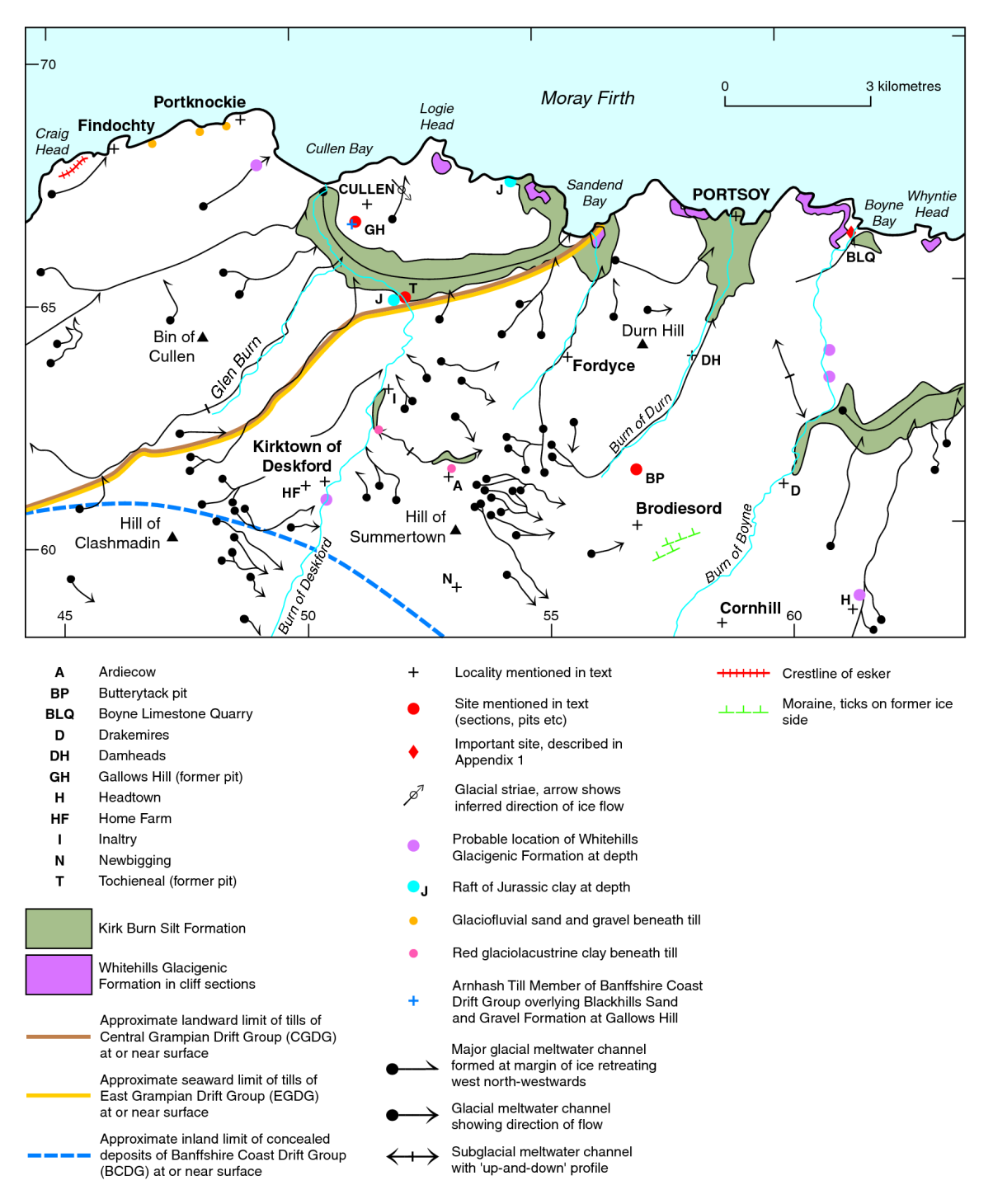
Spreads of clays, silts, sands and gravels extend along the coastal hinterland between Portknockie and New Aberdour on Sheets 96W, 96E and 97. They were first described in detail by Read (1923), who named them the ‘Coastal Deposits’. He also included dark grey shelly tills and clays in the unit, but these lithologies are now known to belong to a separate, underlying formation composed mainly of till (Peacock, 1971), since named as the White-hills Glacigenic Formation (Peacock and Merritt, 1997). The main bodies of sand and gravel within the ‘Coastal Deposits’ are now included in the Blackhills Sand and Gravel Formation. The remaining glaciolacustrine silts and clays are defined as the Kirk Burn Silt Formation, the type section of which occurs at Castle Hill, Gardenstown (Peacock and Merritt, 1997; P915373).

The main outcrops of the Kirk Burn Silt Formation lie between Portknockie and Portsoy, at Macduff, between Gardenstown and Pennan, and to the north of New Aberdour (P915372; P915373; P915374). For the most part the deposits form flat or gently undulating ground within 5 km or so of the coast (Peacock, 1971). The sediments consist mainly of ochreous to dark olive brown, laminated to thin-bedded silts and clays up to about 10 m in thickness. Bands of ferruginous nodules occur locally. Pebbles are not common, but where they do occur, they include clasts of white decalcified Cretaceous limestone. The sediments show signs of settlement and minor movement, including slumping, but there is no evidence that they have been affected by a significant postdepositional glacial advance from inland as deduced by Read (1923), or that they are widely covered by solifluction deposits as described by Synge (1956). They have been deformed apparently by ice moving from the sea at Troup Head (Peacock and Merritt, 2000; P915373).
The deposits of the Kirk Burn Silt Formation were laid down during deglaciation of the Main Late Devensian ice sheet. East Grampian ice had retreated inland but an active ice stream remained in the Moray Firth, forming a barrier a short distance to the north of the present coastline and causing lakes to form against the high ground to the south (P915289). It seems that lakes first formed to the north of New Aberdour, draining eastwards along the coast. A larger lake then formed between Gardenstown and Pennan, draining via the Afforsk Spillway into the valley of the Deveron via the valley of the Idoch Water. Much larger lakes formed subsequently between Portknockie and Macduff.
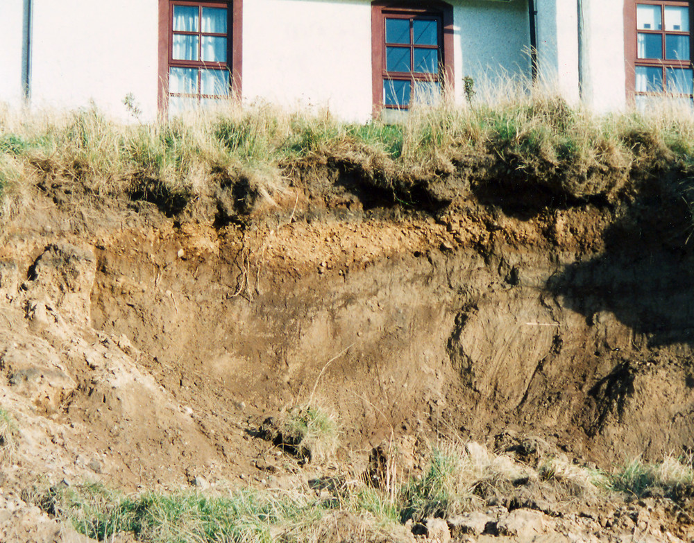
The deposits of the Kirk Burn Silt Formation are prone to landslipping (P104100)).
Glaciomarine deposits
Glaciomarine deposits of the Banffshire Coast Drift Group were laid down during the overall retreat of the Moray Firth ice stream at two distinct localities within the district. The older of the two deposits, the St Fergus Silts Formation, crops out around the Loch of Strathbeg on Sheet 96 and in the vicinity of the St Fergus gas terminal on Sheet 87E. The younger deposit, the Spynie Clay Formation, is associated with Late-glacial raised beaches in the Elgin area.
St Fergus Silt Formation
At the type locality, the St Fergus Silt Formation underlies alluvium of a former freshwater loch that lies behind the belt of coastal sand dunes forming St Fergus Links (NK 124 434), to the north of Peterhead (P915377). The type section is taken to be BGS Borehole NK15SW1 (NK 1030 5344), in which some 16 m of laminated silty clay and clayey silt with sand laminae and shell fragments were recorded, resting on till (McMillan and Aitken, 1981; Peacock, 1999). The deposits vary from dark grey to dark greyish brown, and are both unbedded and laminated, calcareous and contain dispersed clasts up to cobble size that are probably dropstones. The lithology and fauna suggests that the St Fergus Silt Formation is glaciomarine (Hall and Jarvis, 1989; Peacock, 1999), and two adjusted radiocarbon dates of about 14.9 BP and 14.3 BP (Hall and Jarvis, 1989) on marine bivalves (Hiatella arctica) indicate that it was laid down in a period prior to the Windermere Interstadial. The general surface level of the St Fergus Silt Formation and of an associated raised beach imply a marine transgression to at least 12 m OD.
Spynie Clay Formation

Late-glacial raised marine beds composed mainly of silty clay, are associated with raised beaches between Elgin and Lossiemouth on Sheet 95 Elgin. These beds, named the Spynie Clay Formation by Peacock (1999), underlie low-lying ground around Loch Spynie (NJ 237 667) and Lossiemouth Airfield (P915371). The maximum recorded thickness is 12.5 m (Peacock et al., 1968). North of the Spynie basin the formation attains a minimum level of 10 m above OD, and possibly reaches over 20 m OD. On the south side of the basin the mapped level is only a little above OD, probably because the sea was excluded by stagnant ice from this area when sedimentation had begun elsewhere.
The type locality of the Spynie Clay Formation is the former Spynie Claypit (NJ 232 672) (Peacock, 1999), where up to 6 m of sand is underlain by thin beds of shell debris and peat, resting on some 9.5 m of ‘blue’, yellowish red and black clay with scattered boulders, locally interbedded with sand and diamicton (Buchan, 1935; Eyles et al., 1946). Fossils, chiefly the brittle star Ophiocten sericium (formerly Ophiolepis gracilis) (P258468), numerous ‘Leda pygmaea’ (probably Yoldiella lenticula) and rare Portlandia arctica, have been found between 5 and 6.5 m below the surface of the clay (Buchan, 1935). All are decomposed. The regular lamination, the presence of well-dispersed, probably ice-rafted boulders, and the apparent absence of bioturbation support the view that much of the sediment was deposited rapidly in a glaciomarine environment. The low-diversity, high-arctic fauna is similar to that in the Errol Clay Formation of eastern Scotland, which has yielded radiocarbon ages between 12.8 and 14.3 ka BP (Peacock and Browne, 1998; Peacock, 1999).